Ground Control Point Data from the Outer Banks, North Carolina, post-Hurricane Dorian, September 2019

Metadata also available as - [Outline] - [Parseable text] - [XML]

Frequently anticipated questions:


What does this data set describe?

Title:
Ground Control Point Data from the Outer Banks, North Carolina, post-Hurricane Dorian, September 2019
Abstract:
The U.S. Geological Survey (USGS) Remote Sensing Coastal Change (RSCC) project surveyed 34 features visible from the air to be used as ground control points (GCP) on the Outer Banks, North Carolina, on September 24 and 25, 2019, after the passing of Hurricane Dorian (U.S. landfall on September 6, 2019). Global Positioning System (GPS) data were collected in support of aerial imagery surveys documenting the storm impacts and subsequent recovery along the coast and will be used as control and check points in Structure-from-Motion (SfM) photogrammetry processing to produce topographic maps. This dataset consists of horizontal and vertical positions of permanent GCPs, measured using Real-Time Kinematic (RTK) Global Navigation Satellite System (GNSS) equipment. The data are provided in comma-separated values (.csv) delimited text format, in both geographic and projected (Universal Transverse Mercator Zone 18N) coordinates, and vertical measurements are provided as both ellipsoid and orthometric heights. All horizontal coordinates and ellipsoid heights are referenced to the North American Datum of 1983 (NAD83(2011)), and orthometric heights are referenced to the North American Vertical Datum of 1988 (NAVD88), GEOID12B. Additional information as well as photographs for each GCP (120 photos were collected, in total) are also included.
Supplemental_Information:
These data were collected by the USGS Coastal and Marine Hazards and Resources Program under the USGS field activity number (FAN) 2019-365-FA, and the associated field activity web page contains additional information regarding the field activity: https://cmgds.marine.usgs.gov/fan_info.php?fan=2019-365-FA.
  1. How might this data set be cited?
    Brown, Jenna A., Sherwood, Christopher R., Martini, Marinna, Kranenburg, Christine J., and Over, Jin-Si R., 20210408, Ground Control Point Data from the Outer Banks, North Carolina, post-Hurricane Dorian, September 2019: U.S. Geological Survey Data Release doi:10.5066/P9DVZC23, St. Petersburg Coastal and Marine Science Center, St. Petersburg, FL.

    Online Links:

  2. What geographic area does the data set cover?
    West_Bounding_Coordinate: -75.70839064
    East_Bounding_Coordinate: -75.46428182
    North_Bounding_Coordinate: 35.76713430
    South_Bounding_Coordinate: 35.20596290
  3. What does it look like?
    https://coastal.er.usgs.gov/data-release/doi-P9DVZC23/data/2019_0924-0925_OuterBanksNC_GCP_AreaMap.jpg (JPEG)
    Regional map showing the GCP locations along the Outer Banks, North Carolina, measured on September 24-25, 2019.
  4. Does the data set describe conditions during a particular time period?
    Calendar_Date: 24-Sep-2019
    Currentness_Reference:
    ground condition
  5. What is the general form of this data set?
    Geospatial_Data_Presentation_Form: tabular and raster digital data
  6. How does the data set represent geographic features?
    1. How are geographic features stored in the data set?
      This is a Point data set. It contains the following vector data types (SDTS terminology):
      • Point (34)
    2. What coordinate system is used to represent geographic features?
      Grid_Coordinate_System_Name: Universal Transverse Mercator
      Universal_Transverse_Mercator:
      UTM_Zone_Number: 18
      Transverse_Mercator:
      Scale_Factor_at_Central_Meridian: 0.999600
      Longitude_of_Central_Meridian: -75.000000
      Latitude_of_Projection_Origin: 0.000000
      False_Easting: 500000.000000
      False_Northing: 0.000000
      Planar coordinates are encoded using coordinate pair
      Abscissae (x-coordinates) are specified to the nearest 0.001
      Ordinates (y-coordinates) are specified to the nearest 0.001
      Planar coordinates are specified in meters
      The horizontal datum used is North American Datum of 1983 (2011).
      The ellipsoid used is GRS 1980.
      The semi-major axis of the ellipsoid used is 6378137.0.
      The flattening of the ellipsoid used is 1/298.257223563.
      Vertical_Coordinate_System_Definition:
      Altitude_System_Definition:
      Altitude_Datum_Name: North American Vertical Datum of 1988
      Altitude_Resolution: 0.001
      Altitude_Distance_Units: meters
      Altitude_Encoding_Method:
      Explicit elevation coordinate included with horizontal coordinates
  7. How does the data set describe geographic features?
    2019_0924-0925_OuterBanksNC_GCPs.csv
    Comma-delimited text file containing position, elevation, and other information related to GCPs surveyed along the Outer Banks, North Carolina, after Hurricane Dorian in September 2019. (Source: U.S. Geological Survey)
    GCP Identifier
    Identifier associated with each individual GCP, numbered consecutively from north to south. (Source: U.S. Geological Survey) GCP Identifiers range between GCP01 and GCP34.
    Raw GPS Point
    GPS point measurement number in the raw GPS data file associated with each individual GCP, numbered consecutively in time. (Source: U.S. Geological Survey)
    Range of values
    Minimum:5
    Maximum:77
    Units:N/A
    Local Date
    Local date of data collection in MM/DD/YYYY format. (Source: U.S. Geological Survey)
    Range of values
    Minimum:09/24/2019
    Maximum:09/25/2019
    Units:N/A
    GMT Time
    Greenwich Mean Time (GMT) time of start of GCP occupation in HH:MM:SS format. (Source: U.S. Geological Survey)
    Range of values
    Minimum:13:33:42
    Maximum:22:06:39
    Units:N/A
    Local Time
    Local time (Eastern Daylight Time) of start of GCP occupation in HH:MM:SS format. (Source: U.S. Geological Survey)
    Range of values
    Minimum:09:33:42
    Maximum:18:06:39
    Units:N/A
    Easting (NAD83, UTM 18N)
    NAD83(2011) UTM x-axis coordinate (Zone 18N) (Source: U.S. Geological Survey)
    Range of values
    Minimum:435965.801
    Maximum:457740.388
    Units:Meters
    Northing (NAD83, UTM 18N)
    NAD83(2011) UTM y-axis coordinate (Zone 18N) (Source: U.S. Geological Survey)
    Range of values
    Minimum:3896110.603
    Maximum:3958221.519
    Units:Meters
    Orthometric Height (NAVD88, m)
    NAVD88 (GEOID12B) orthometric height (Source: U.S. Geological Survey)
    Range of values
    Minimum:0.805
    Maximum:4.71
    Units:Meters
    Longitude (NAD83)
    NAD83(2011) Longitude (Source: U.S. Geological Survey)
    Range of values
    Minimum:-75.703493
    Maximum:-75.466411
    Units:Decimal Degrees
    Latitude (NAD83)
    NAD83(2011) Latitude (Source: U.S. Geological Survey)
    Range of values
    Minimum:35.205963
    Maximum:35.766894
    Units:Decimal Degrees
    Ellipsoid Height (NAD83, m)
    NAD83(2011) ellipsoid height (Source: U.S. Geological Survey)
    Range of values
    Minimum:-38.017
    Maximum:-34.165
    Units:Meters
    STDEV Horizontal (m)
    Horizontal (x,y) standard deviation of the individual GCP, in meters, reported by GPS during data collection. (Source: U.S. Geological Survey)
    Range of values
    Minimum:0.007
    Maximum:0.012
    Units:Meters
    STDEV Vertical (m)
    Vertical (z) standard deviation of the individual GCP, in meters, reported by GPS during data collection. (Source: U.S. Geological Survey)
    Range of values
    Minimum:0.011
    Maximum:0.017
    Units:Meters
    Number of Photos
    Total number of reference photos of each GCP. Photos are named GCP**_P#######, where ** represents the GCP ID and P####### represents the original photo name/number. A total of 120 photos were collected. (Source: U.S. Geological Survey)
    Range of values
    Minimum:2
    Maximum:6
    Units:N/A
    Notes
    Notes describing the features and location of each GCP. (Source: U.S. Geological Survey) N/A

Who produced the data set?

  1. Who are the originators of the data set? (may include formal authors, digital compilers, and editors)
    • Jenna A. Brown
    • Christopher R. Sherwood
    • Marinna Martini
    • Christine J. Kranenburg
    • Jin-Si R. Over
  2. Who also contributed to the data set?
    Data collection was funded by the U.S. Geological Survey.
  3. To whom should users address questions about the data?
    Jenna A. Brown
    U.S. Geological Survey, MD-DE-DC Water Science Center
    1289 McD Dr.
    Dover, DE
    USA

    302-213-5071 (voice)
    jennabrown@usgs.gov

Why was the data set created?

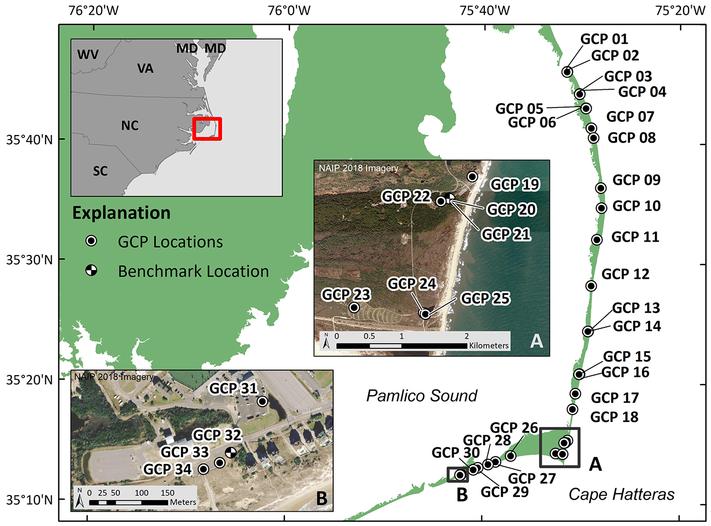
The purpose of this dataset is to provide geospatial GCP data in support of aerial imagery surveys along the coast of the Outer Banks, North Carolina; these data can be used as control and check points in SfM processing to create and validate orthomosaic images, point clouds, and digital elevation models (DEMs).

How was the data set created?

  1. From what previous works were the data drawn?
  2. How were the data generated, processed, and modified?
    Date: 25-Sep-2019 (process 1 of 3)
    PLANNING & DATA ACQUISITION Optimal survey locations were pre-planned using available aerial imagery, with the following criteria for selecting a GCP: easily identified in aerial images, permanent and stationary feature, surrounded by open sky, and with limited relief from the surrounding surface. Additionally, some opportunistic points were chosen in the field.
    The GPS data were collected with a single Spectra Precision SP80 GNSS receiver, mounted on a 2-meter survey pole attached to a tripod, connected to the GNSS Continuously Operating Reference Stations (CORS) network, NCBX site in Buxton, North Carolina. At each GCP location, RTK corrections were sampled at 1-second intervals for 60 seconds and the average position (latitude/longitude/ellipsoid height) was recorded in the World Geodetic System of 1984 (WGS84) datum; the GNSS antenna height was accounted for during data collection and export. Multiple RTK average positions were collected for most GCPs to ensure data accuracy and consistency. Additionally, reference photos of each GCP were taken during the survey to aid in identifying the GCPs in aerial imagery. These GCP surveying procedures were based on work by Sherwood and others (2018). Person who carried out this activity:
    Christopher R. Sherwood
    U.S. Geological Survey, Woods Hole Coastal and Marine Science Center
    Research Oceanographer
    384 Woods Hole Rd
    Woods Hole, MA
    USA

    508-457-2269 (voice)
    csherwood@usgs.gov
    Date: 25-Oct-2019 (process 2 of 3)
    DATA POST-PROCESSING & QUALITY CONTROL The data were post-processed using VDatum (version 3.8) to convert from WGS84 to the NAD83(2011) geodetic datum, and the geographic coordinates were transformed to projected coordinates (UTM Zone 18N) and orthometric height referenced to NAVD88 using GEOID12B (NOS, 2012).
    The data were condensed by evaluating the multiple RTK average position measurements per GCP; the horizontal standard deviation of all GPS points was within the stated horizontal accuracy for the survey, therefore, the point with the greatest vertical accuracy was selected for publication. Additionally, the data were quality-controlled and unusable points were removed from the dataset: points collected for equipment testing, points with less than 60 seconds occupation, points without an open sky view. Person who carried out this activity:
    Christine J. Kranenburg
    U.S. Geological Survey, St. Petersburg Coastal and Marine Science Center
    Cartographer
    600 4th Street South
    St. Petersburg, FL
    USA

    727-502-8000 (voice)
    ckranenburg@usgs.gov
    Date: 08-Dec-2020 (process 3 of 3)
    DATA PUBLICATION The data were prepared for publication by saving the horizontal and vertical position data for each GCP in a single file (2019_0924-0925_OuterBanksNC_GCPs.csv). Notes describing the measured GCP feature, as well as the approximate location along the coast, were also given for each GCP to aid in identifying the GCPs in aerial imagery.
    Reference photos for each GCP were saved in separate directories, to also aid in identifying the GCPs in aerial imagery. Metadata was written to all photo headers using a script and batch processing to execute ExifTool (https://exiftool.org/) and populate fields with information for each GCP from the .csv file. To extract the information from the image headers using ExifTool, the following command can be used (tested with ExifTool version 11.88):
    exiftool -csv -f -filename -GPSDateStamp -GPSTimeStamp -GPSLongitude -GPSLatitude -n -Artist -Credit -comment -keywords -Caption -Copyright -CopyrightNotice -Caption-Abstract -ImageDescription directoryname/*.jpg > out.csv
    The -csv flag writes the information out in a comma-delimited format. The -n option formats the latitude and longitude as signed decimal degrees. Person who carried out this activity:
    Jenna A. Brown
    U.S. Geological Survey, MD-DE-DC Water Science Center
    Research Oceanographer
    1289 McD Dr.
    Dover, DE
    USA

    302-213-5071 (voice)
    jennabrown@usgs.gov
  3. What similar or related data should the user be aware of?
    Sherwood, C.R., Warrick, J.A., Hill, A.D., Ritchie, A.C., Andrews, B.D., and Plant, N.P., 20180712, Rapid, Remote Assessment of Hurricane Matthew Impacts Using Four-Dimensional Structure-from-Motion Photogrammetry: Journal of Coastal Research doi.org/10.2112/JCOASTRES-D-18-00016.1, Coastal Education and Research Foundation, Coconut Creek, Florida.

    Online Links:

    Service, National Ocean, 20120601, VDATUM MANUAL FOR DEVELOPMENT AND SUPPORT OF NOAA’S VERTICAL DATUM TRANSFORMATION TOOL, VDATUM.

    Online Links:


How reliable are the data; what problems remain in the data set?

  1. How well have the observations been checked?
    The accuracy of the GPS data was determined based on the measurement of two established benchmarks in the area; see the “Notes” attribute in the data file to identify the GCPs corresponding to benchmarks.
  2. How accurate are the geographic locations?
    The horizontal accuracy of the GPS data is on the order of 0.034 meters (m), determined as the maximum difference between the reported horizontal position for two established benchmarks in the area and the corresponding RTK measurement.
  3. How accurate are the heights or depths?
    The vertical accuracy of the data is on the order of 0.047 m, determined as the maximum difference between the reported vertical position for two established benchmarks in the area and the corresponding RTK measurement.
  4. Where are the gaps in the data? What is missing?
    This dataset is considered complete for the information presented, as described in the abstract. Users are advised to read the entire metadata record carefully for additional details.
  5. How consistent are the relationships among the observations, including topology?
    This dataset is derived from a single field survey using identical equipment, set-ups, and staff; therefore, the dataset is internally consistent.

How can someone get a copy of the data set?

Are there legal restrictions on access or use of the data?
Access_Constraints: None
Use_Constraints:
USGS-authored or produced data and information are in the public domain from the U.S. Government and are freely redistributable with proper metadata and source attribution. Please recognize and acknowledge the U.S. Geological Survey as the originator of the dataset and in products derived from these data.
  1. Who distributes the data set? (Distributor 1 of 1)
    U.S. Geological Survey, St. Petersburg Coastal and Marine Science Center
    Attn: SPCMSC Data Management Group
    600 4th Street South
    St. Petersburg, FL
    USA

    727-502-8125 (voice)
    gs-g-spcmsc_data_inquiries@usgs.gov
  2. What's the catalog number I need to order this data set? The GCP locations, elevations, and other notable information are available in .csv format, and associated reference photos of each GCP are available in .jpg format.
  3. What legal disclaimers am I supposed to read?
    This publication was prepared by an agency of the United States Government. Although these data were processed successfully on a computer system at the U.S. Geological Survey, no warranty expressed or implied is made regarding the display or utility of the data on any other system, nor shall the act of distribution imply any such warranty. The U.S. Geological Survey shall not be held liable for improper or incorrect use of the data described and (or) contained herein. Reference herein to any specific commercial product, process, or service by trade name, trademark, manufacturer, or otherwise does not constitute or imply its endorsement, recommendation, or favoring by the United States Government or any agency thereof.
  4. How can I download or order the data?

Who wrote the metadata?

Dates:
Last modified: 07-Apr-2021
Metadata author:
Jenna A. Brown
U.S. Geological Survey, MD-DE-DC Water Science Center
1289 McD Dr.
Dover, DE
USA

302-213-5071 (voice)
jennabrown@usgs.gov
Metadata standard:
Content Standard for Digital Geospatial Metadata (FGDC-STD-001-1998)

This page is <https://cmgds.marine.usgs.gov/catalog/spcmsc/2019_0924-0925_OuterBanksNC_GCPs_metadata.faq.html>
Generated by mp version 2.9.50 on Tue Sep 21 18:18:31 2021