Citation:
Citation_Information:
Originator: Karen L.M. Morgan
Originator: M. Dennis Krohn
Originator: Russell Peterson
Originator: Phillip R. Thompson
Originator: Janice Subino
Publication_Date: 2015
Title:
Post-Hurricane Ivan coastal oblique aerial photographs collected from Crawfordville, Florida, to Petit Bois Island, Mississippi, September 17, 2004
Geospatial_Data_Presentation_Form: Multimedia
Series_Information:
Series_Name: U.S. Geological Survey Data Series
Issue_Identification: Data Series 945
Publication_Information:
Publication_Place: St. Petersburg, Fla.
Publisher: U.S. Geological Survey
Online_Linkage: http://pubs.usgs.gov/ds/0945
Description:
Abstract:
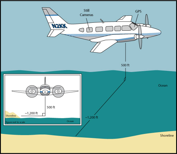
The U.S. Geological Survey (USGS) conducts baseline and storm response photography missions to document and understand the changes in vulnerability of the Nation's coasts to extreme storms. On September 17, 2004, the USGS conducted an oblique aerial photographic survey from Crawfordville, Florida, to Petit Bois Island, Mississippi, aboard a Piper Navajo Chieftain aircraft at an altitude of 500 feet (ft) and approximately 1,000 ft offshore (Figure 2,
http://pubs.usgs.gov/ds/0945/html/ds945_fig2.html). This mission was flown to collect data for assessing incremental changes since the last survey, flown July 2001 (
https://cmgds.marine.usgs.gov/fan_info.php?fan=04ACH03), and can be used for assessing future coastal change. The photographs provided here are Joint Photographic Experts Group (JPEG) images. The photograph locations are an estimate of the position of the aircraft and do not indicate the location of the feature in the images (see Navigation Data page,
http://pubs.usgs.gov/ds/0945/html/ds945_nav.html). These photographs document the configuration of the barrier islands and other coastal features at the time of the survey. ExifTool (
http://www.sno.phy.queensu.ca/~phil/exiftool/) is a free software program for reading, writing, and manipulating image, audio, and video metadata. ExifTool was used to add the following to the header of each photo: time of collection, Global Positioning System (GPS) latitude, GPS longitude, keywords, credit, artist (photographer), caption, copyright, and contact information. Photographs can be opened directly with any JPEG-compatible image viewer by clicking on a thumbnail on the contact sheet. All image times are recorded in UTC. Table 1 (
http://pubs.usgs.gov/ds/0945/html/ds945_table.html) provides detailed information about the assigned location, name, date, and time the photograph was taken along with a link to the photograph. In addition to the photographs, a Google Earth Keyhole Markup Language (KML) file is provided and can be used to view the images by clicking on the marker and then clicking on either the thumbnail or the link above the thumbnail. The KML files were created using the photographic navigation files. Note: A KML number was assigned to each photograph to aid navigation of the Google Earth file. These numbers correspond to the site labels in Google Earth.
To provide access to digital photographs taken as part of the September 17, 2004, post-Hurricane Ivan oblique aerial survey collected along the coast, from Crawfordville, Florida, to Petit Bois Island, Mississippi, and to provide access to attribute data that document the time and location of where each photograph was taken.
Supplemental_Information:
Time_Period_of_Content:
Time_Period_Information:
Range_of_Dates/Times:
Beginning_Date: 20040917
Ending_Date: 20040917
Currentness_Reference: ground condition
Status:
Progress: Complete
Maintenance_and_Update_Frequency: as needed
Spatial_Domain:
Bounding_Coordinates:
West_Bounding_Coordinate: -89.06616667
East_Bounding_Coordinate: -82.606625
North_Bounding_Coordinate: 30.42316667
South_Bounding_Coordinate: 27.76293889
Keywords:
Theme:
Theme_Keyword_Thesaurus: USGS Metadata Identifier
Theme_Keyword: USGS:d5e40db4-b637-4b3e-a533-7c1da827e86e
Theme:
Theme_Keyword_Thesaurus: General
Theme_Keyword: U.S. Geological Survey
Theme_Keyword: National Assessment Project
Theme_Keyword: photographs
Theme_Keyword: coastline
Theme_Keyword: beach erosion
Theme_Keyword: Coastal Aerial Photography
Theme_Keyword: Hurricane Ivan
Theme:
Theme_Keyword_Thesaurus: ISO 19115 Topic Category
Theme_Keyword: environment
Theme_Keyword: imageryBaseMapsEarthCover
Theme_Keyword: structure
Place:
Place_Keyword_Thesaurus: Geographic Names Information Service (GNIS)
Place_Keyword: Florida
Place_Keyword: Alabama
Place_Keyword: Mississippi
Place_Keyword: Mississippi Barrier Islands
Place_Keyword: Alabama Barrier Islands
Place_Keyword: Florida Barrier Islands
Place_Keyword: Dauphin Island
Place_Keyword: Petit Bois Island
Temporal:
Temporal_Keyword_Thesaurus: General
Temporal_Keyword: 2004
Access_Constraints: None
Use_Constraints:
The U.S. Geological Survey requests to be acknowledged as originator of the data in future products or derivative research.
Point_of_Contact:
Contact_Information:
Contact_Person_Primary:
Contact_Person: K. Morgan
Contact_Organization: USGS
Contact_Position: Geologist
Contact_Address:
Address_Type: Physical and Mailing
Address: 600 4th Street South
City: St. Petersburg
State_or_Province: FL
Postal_Code: 33701
Country: USA
Contact_Voice_Telephone: (727) 502-8037
Contact_Electronic_Mail_Address: kmorgan@usgs.gov
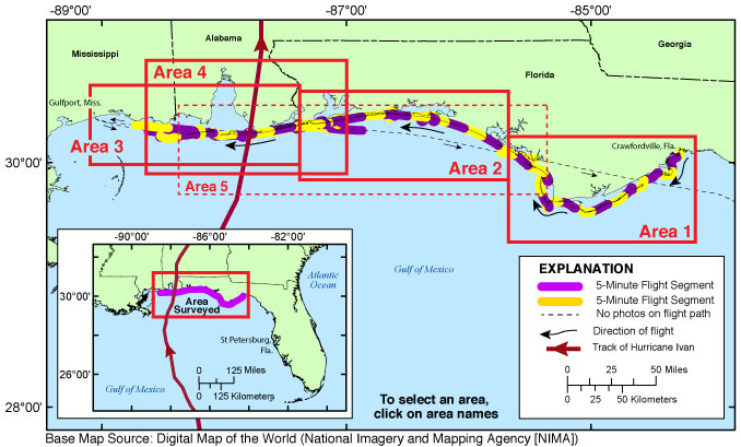
Browse_Graphic:
Browse_Graphic_File_Name: http://pubs.usgs.gov/ds/0945/maps/index.jpg
Browse_Graphic_File_Description:
Index map of all survey areas covered during USGS field activity 04ACH03. Red line shows the storm track (provided by Unisys Weather and The Weather Underground).
Browse_Graphic_File_Type: JPEG
Browse_Graphic:
Browse_Graphic_File_Name: http://pubs.usgs.gov/ds/0945/html/images/fig2.jpg
Browse_Graphic_File_Description:
Graphic for Acquisition Geometry (Figure 2) for USGS field activity 04ACH03. Graphic shows basic flight distance from the shore and elevation during the survey for the aircraft used.
Browse_Graphic_File_Type: JPEG
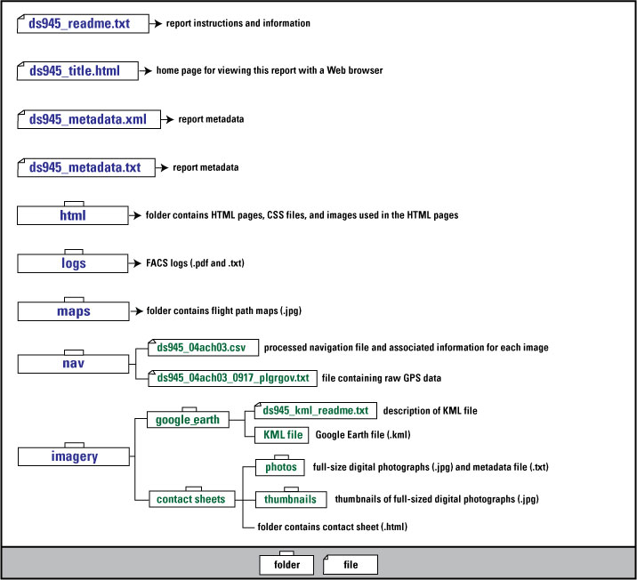
Browse_Graphic:
Browse_Graphic_File_Name: http://pubs.usgs.gov/ds/0945/html/images/contents.jpg
Browse_Graphic_File_Description:
Graphic used on Contents page of USGS field activity 04ACH03 oblique aerial photographs Data Deries. Graphic shows the directory structure of the publication.
Browse_Graphic_File_Type: JPEG
Browse_Graphic:
Browse_Graphic_File_Name: http://pubs.usgs.gov/ds/0945/maps/04ach03_1.jpg
Browse_Graphic_File_Description:
Map showing the extent of Area 1 for the post-Hurricane Ivan coastal oblique aerial photographs from Crawfordville, Florida, to Panama City, Florida. The flight path, divided into 5-minute segments, is represented by the alternating purple and yellow lines. Pages containing thumbnail images of photographs, referred to as contact sheets, were created based on these segments.
Browse_Graphic_File_Type: JPEG
Browse_Graphic:
Browse_Graphic_File_Name: http://pubs.usgs.gov/ds/0945/maps/04ach03_2.jpg
Browse_Graphic_File_Description:
Map showing the extent of Area 2 for the post-Hurricane Ivan coastal oblique aerial photographs from Laguna Beach, Florida to Pensacola Beach, Florida. The flight path, divided into 5-minute segments, is represented by the alternating purple and yellow lines. Pages containing thumbnail images of photographs, referred to as contact sheets, were created based on these segments.
Browse_Graphic_File_Type: JPEG
Browse_Graphic:
Browse_Graphic_File_Name: http://pubs.usgs.gov/ds/0945/maps/04ach03_3.jpg
Browse_Graphic_File_Description:
Map showing the extent of Area 3 for the post-Hurricane Ivan coastal oblique aerial photographs from Fort McRee, Florida, to Gulfport, Mississippi. The flight path, divided into 5-minute segments, is represented by the alternating purple and yellow lines. Pages containing thumbnail images of photographs, referred to as contact sheets, were created based on these segments. The red line shows the storm track (provided by the Unisys Weather and The Weather Underground).
Browse_Graphic_File_Type: JPEG
Browse_Graphic:
Browse_Graphic_File_Name: http://pubs.usgs.gov/ds/0945/maps/04ach03_4.jpg
Browse_Graphic_File_Description:
Map showing the extent of Area 4 for the post-Hurricane Ivan coastal oblique aerial photographs from Fort McRee, Florida, to Petit Bois Island, Alabama. The flight path, divided into 5-minute segments, is represented by the alternating purple and yellow lines. Pages containing thumbnail images of photographs, referred to as contact sheets, were created based on these segments. The red line shows the storm track (provided by the Unisys Weather and The Weather Underground).
Browse_Graphic_File_Type: JPEG
Browse_Graphic:
Browse_Graphic_File_Name: http://pubs.usgs.gov/ds/0945/maps/04ach03_5.jpg
Browse_Graphic_File_Description:
Map showing the extent of Area 5 for the post-Hurricane Ivan coastal oblique aerial photographs from Dauphin Island, Alabama, to Perdido Key, Florida, and continuing on to Panama City, Florida. The flight path, divided into 5-minute segments, is represented by the alternating purple and yellow lines. Pages containing thumbnail images of photographs, referred to as contact sheets, were created based on these segments. The red line shows the storm track (provided by Unisys Weather and The Weather Underground).
Browse_Graphic_File_Type: JPEG
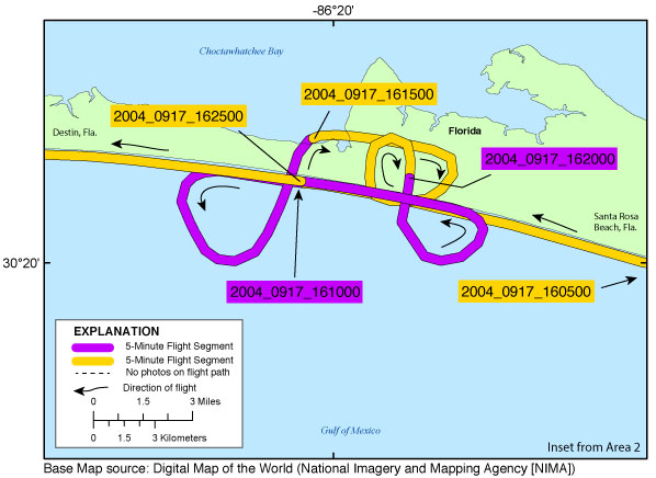
Browse_Graphic:
Browse_Graphic_File_Name: http://pubs.usgs.gov/ds/0945/maps/inset04_miramarbch.jpg
Browse_Graphic_File_Description:
Inset map showing the extent of inset04_miramarbch.jpg for the post-Hurricane Ivan coastal oblique aerial photographs from Santa Rosa Beach to Destin, Florida. The flight path, divided up into 5-minute segments, is represented by the alternating purple and yellow lines. Pages containing thumbnail images of photographs, referred to as contact sheets, were created based on these segments.
Browse_Graphic_File_Type: JPEG
Browse_Graphic:
Browse_Graphic_File_Name: http://pubs.usgs.gov/ds/0945/maps/inset05_ftwaltonbch.jpg
Browse_Graphic_File_Description:
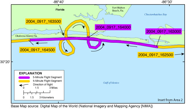
Inset map showing the extent of inset05_ftwaltonbch.jpg for the post-Hurricane Ivan coastal oblique aerial photographs on Okaloosa Island at Fort Walton Beach, Florida. The flight path, divided up into 5-minute segments, is represented by the alternating purple and yellow lines. Pages containing thumbnail images of photographs, referred to as contact sheets, were created based on these segments.
Browse_Graphic_File_Type: JPEG
Browse_Graphic:
Browse_Graphic_File_Name: http://pubs.usgs.gov/ds/0945/maps/inset06_pensacolabch.jpg
Browse_Graphic_File_Description:
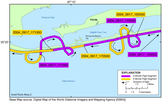
Inset map showing the extent of inset06_pensacolabch.jpg for the post-Hurricane Ivan coastal oblique aerial photographs at Pensacola Beach, Florida. The flight path, divided up into 5-minute segments, is represented by the alternating purple and yellow lines. Pages containing thumbnail images of photographs, referred to as contact sheets, were created based on these segments.
Browse_Graphic_File_Type: JPEG
Browse_Graphic:
Browse_Graphic_File_Name: http://pubs.usgs.gov/ds/0945/maps/inset07_perdidokey.jpg
Browse_Graphic_File_Description:
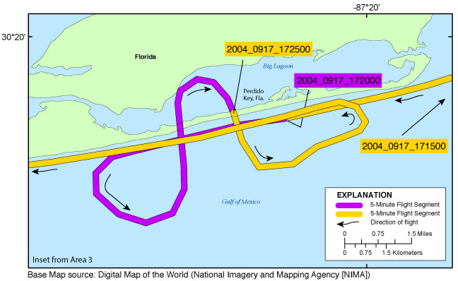
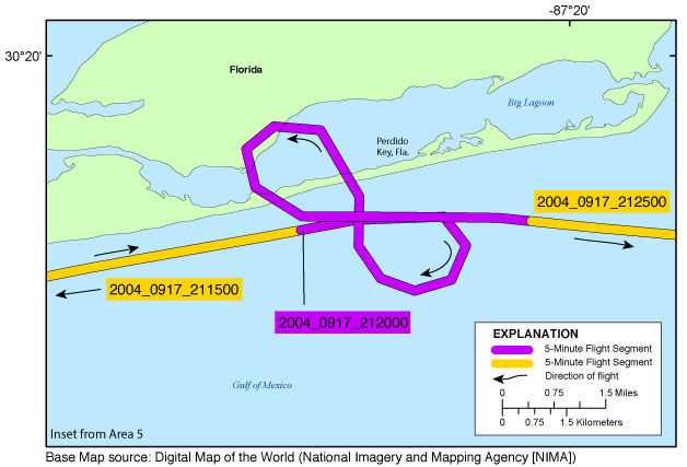
Inset map showing the extent of inset07_perdidokey.jpg for the post-Hurricane Ivan coastal oblique aerial photographs at the east end of Perdido Key, Florida. The flight path, divided up into 5-minute segments, is represented by the alternating purple and yellow lines. Pages containing thumbnail images of photographs, referred to as contact sheets, were created based on these segments.
Browse_Graphic_File_Type: JPEG
Browse_Graphic:
Browse_Graphic_File_Name: http://pubs.usgs.gov/ds/0945/maps/inset08_dauphin.jpg
Browse_Graphic_File_Description:
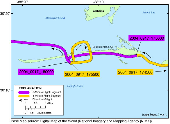
Inset map showing the extent of inset08_dauphin.jpg for the post-Hurricane Ivan coastal oblique aerial photographs Dauphin Island. The flight path, divided up into 5-minute segments, is represented by the alternating purple and yellow lines. Pages containing thumbnail images of photographs, referred to as contact sheets, were created based on these segments.
Browse_Graphic_File_Type: JPEG
Browse_Graphic:
Browse_Graphic_File_Name: http://pubs.usgs.gov/ds/0945/maps/inset09_gulfshr.jpg
Browse_Graphic_File_Description:
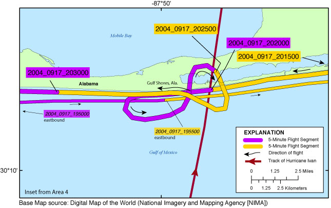
Inset map showing the extent of inset09_gulfshr.jpg for the post-Hurricane Ivan coastal oblique aerial photographs at Gulf Shores, Alabama. The flight path, divided up into 5-minute segments, is represented by the alternating purple and yellow lines. Pages containing thumbnail images of photographs, referred to as contact sheets, were created based on these segments. Red line shows the storm track (provided by Unisys Weather and The Weather Underground).
Browse_Graphic_File_Type: JPEG
Browse_Graphic:
Browse_Graphic_File_Name: http://pubs.usgs.gov/ds/0945/maps/inset10_perdidokey.jpg
Browse_Graphic_File_Description:
Inset map showing the extent of inset10_perdidokey.jpg for the post-Hurricane Ivan coastal oblique aerial photographs at the east end of Perdido Key, Florida. The flight path, divided up into 5-minute segments, is represented by the alternating purple and yellow lines. Pages containing thumbnail images of photographs, referred to as contact sheets, were created based on these segments.
Browse_Graphic_File_Type: JPEG
Data_Set_Credit:
Funding and (or) support for this study was provided by the USGS Coastal and Marine Geology Program (CMGP). The authors wish to thank the pilot, Mark Frame, for his assistance in data collection. This report benefited from the comments and reviews of Bryan McCloskey and Justin Birchler of Cherokee Nation Technology Solutions contracted to U.S. Geological Survey St. Petersburg Coastal and Marine Science Center (SPCMSC), St. Petersburg, Florida.