EAARL Coastal Topography-Northern Gulf of Mexico

Metadata also available as - [Questions & Answers] - [Parseable text] - [XML]

Metadata:

Identification_Information:
Citation:
Citation_Information:
Originator: U.S. Geological Survey
Publication_Date: 20081027
Publication_Time: 0900
Title: EAARL Coastal Topography-Northern Gulf of Mexico
Edition: first
Geospatial_Data_Presentation_Form: remote-sensing image
Series_Information:
Series_Name: Data Series
Issue_Identification: 384
Publication_Information:
Publication_Place: FISC Saint Petersburg
Publisher: U. S. Geological Survey
Online_Linkage: http://pubs.usgs.gov/ds/384/
Description:
Abstract:
ASCII xyz point cloud data were produced from remotely-sensed, geographically-referenced elevation measurements in cooperation with the U.S. Geological Survey (USGS) and National Air and Space Administration (NASA). Elevation measurements were collected over the area using the NASA Experimental Advanced Airborne Research Lidar (EAARL), a pulsed laser ranging system mounted onboard an aircraft to measure ground elevation, vegetation canopy, and coastal topography. The system uses high-frequency laser beams directed at the earth's surface through an opening in the bottom of the aircraft's fuselage. The laser system records the time difference between emission of the laser beam and the reception of the reflected laser signal in the aircraft. The plane travels over the target area at approximately 50 meters per second at an elevation of approximately 300 meters. The EAARL, developed by NASA at Wallops Flight Facility in Virginia, measures ground elevation with a vertical resolution of 15 centimeters. A sampling rate of 3 kHz or higher results in an extremely dense spatial elevation data set. Over 100 kilometers of coastline can be easily surveyed within a 3 to 4 hour mission time period. When subsequent elevation maps for an area are analyzed, they provide a useful tool to make management decisions regarding land development.
For more information on Lidar science and the Experimental Advanced Airborne Research Lidar (EAARL) system and surveys, see http://ngom.usgs.gov/dsp/overview/index.php and http://ngom.usgs.gov/dsp/tech/eaarl/index.php .
Purpose:
The ASCII elevation data can be used to create raster Digital Elevation Models (DEMs). The purpose of this project is to produce highly detailed and accurate digital elevation maps of the post Hurricane Ivan data for use as a management tool and to make this data available to natural resource managers and research scientists.
Supplemental_Information:
Raw lidar data is not in a format that is generally usable by resource managers and scientists. Converting dense Lidar elevation data into a readily usable format without loss of essential information requires specialized processing. The U. S. Geological Survey's Coastal and Marine Geology (CMG) Program has developed custom software to convert raw lidar data into a GIS compatible map product to be provided to GIS specialists, managers, and scientists. The primary tool used in the conversion process is Advanced Lidar Processing System (ALPS), a multi-tiered processing system developed by a USGS/NASA collaborative project. Specialized processing algorithms are used to convert raw waveform Lidar data acquired by the EAARL to georeferenced spot (x,y,z) returns for "first surface" and "bare earth" topography. These data are then converted to the North American Datum of 1983 and the North American Vertical Datum of 1988 (using the Geoid 03 model). The files are in the Quarter Quad tiling format and the exact tile location is contained in the filename at n88_########_mf_be where ####### is the Quarter Quad tile ID.The development of custom software for creating these data products has been supported by the USGS CMG Program's 'Decision Support for Coastal Parks, Sanctuaries, and Preserves' project. Processed data products are used by the USGS CMG Program's 'National Assessments of Coastal Change Hazards Project' to quantify the vulnerability of shorelines to coastal change hazards such as severe storms, sea-level rise, and shoreline erosion and retreat.
Time_Period_of_Content:
Time_Period_Information:
Single_Date/Time:
Calendar_Date: 20040919
Currentness_Reference: ground condition
Status:
Progress: Complete
Maintenance_and_Update_Frequency: As needed
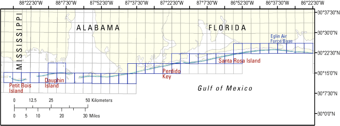
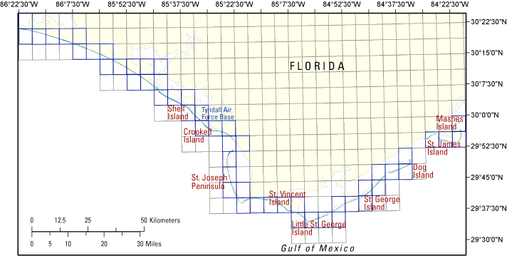
Spatial_Domain:
Bounding_Coordinates:
West_Bounding_Coordinate: -88.875
East_Bounding_Coordinate: -84.5
North_Bounding_Coordinate: 30.625
South_Bounding_Coordinate: 29.375
Keywords:
Theme:
Theme_Keyword_Thesaurus: USGS Metadata Identifier
Theme_Keyword: USGS:28ad40f2-b08d-4c0f-982b-5e016e448134
Theme:
Theme_Keyword_Thesaurus: ISO Topic Keywords 19115
Theme_Keyword: elevation
Theme:
Theme_Keyword_Thesaurus: http://remotesensing.usgs.gov
Theme_Keyword: Lidar
Theme_Keyword: Experimental Advanced Airborne Research Lidar
Theme_Keyword: EAARL
Theme_Keyword: Digital Elevation Model
Theme_Keyword: elevation change
Theme_Keyword: laser altimetry
Theme_Keyword: derived surface
Theme_Keyword: resource management
Theme_Keyword: ALPS
Theme_Keyword: Advanced Lidar Processing System
Theme_Keyword: Hurricanes
Theme_Keyword: Ivan
Theme:
Theme_Keyword_Thesaurus: Data Categories for Marine Planning
Theme_Keyword: distributions
Theme_Keyword: bathymetry and elevation
Theme:
Theme_Keyword_Thesaurus: Marine Realms Information Bank (MRIB) Keywords
Theme_Keyword: altimetry
Theme_Keyword: topographic mapping
Theme:
Theme_Keyword_Thesaurus: USGS Thesaurus
Theme_Keyword: LIDAR
Theme_Keyword: topography
Theme_Keyword: digital elevation models
Place:
Place_Keyword_Thesaurus: http://nationalmap.gov
Place_Keyword: Florida
Place_Keyword: Mississippi
Place_Keyword: Alabama
Stratum:
Stratum_Keyword_Thesaurus: http://lidar.cr.usgs.gov/
Stratum_Keyword: Bare earth
Temporal:
Temporal_Keyword_Thesaurus: http://www.esri.com/news/arcuser/1104/temporal.html
Temporal_Keyword: 2004
Access_Constraints: None
Use_Constraints:
The U.S. Geological Survey and National Aeronautics and Space Administration request to be acknowledged as originators of the data in future products or derivative research.
Point_of_Contact:
Contact_Information:
Contact_Organization_Primary:
Contact_Organization: Jacobs Technology, contracted to USGS
Contact_Person: Amar Nayegandhi or John Brock at USGS
Contact_Position: Computer Scientist
Contact_Address:
Address_Type: mailing and physical address
Address: 600 4th Street South
City: Saint Petersburg
State_or_Province: FL
Postal_Code: 33701
Country: USA
Contact_Voice_Telephone: 727-803-8747
Contact_Electronic_Mail_Address: anayegandhi@usgs.gov
Contact_Electronic_Mail_Address: jbrock@usgs.gov
Hours_of_Service: M-F 8:30-5:00 EST
Browse_Graphic:
Browse_Graphic_File_Name: http://pubs.usgs.gov/ds/384/html/images/GUIS_west_txt.gif
Browse_Graphic_File_Description: EAARL Coastal Topography-Northern Gulf of Mexico - West
Browse_Graphic_File_Type: GIF
Browse_Graphic:
Browse_Graphic_File_Name: http://pubs.usgs.gov/ds/384/html/images/NGOM_FL_east.gif
Browse_Graphic_File_Description: EAARL Coastal Topography-Northern Gulf of Mexico - East
Browse_Graphic_File_Type: GIF
Data_Set_Credit:
The U. S. Geological Survey is providing these data "as is", and the U. S. Geological Survey disclaims any and all warranties, whether expressed or implied, including (without limitation) any implied warranties of merchantability or fitness for a particular purpose. In no event will the U. S. Geological Survey be liable to you or to any third party for any direct, indirect, incidental, consequential, special, or exemplary damages or lost profits resulting from any use or misuse of these data. Acknowledgement of the U.S. Geological Survey, Florida Integrated Science Center as a data source would be appreciated in products developed from these data, and such acknowledgement as is standad for citation and legal practices for data source is expected by users of this data. Sharing new data layers developed directly from these data would also be appreciated by the U. S. Geological Survey staff. Users should be aware that comparisons with other data sets for the same area from other time periods may be inaccurate due to inconsistencies resulting from changes in photo interpretation, mapping conventions, and digital processes over time. These data are not legal documents and are not to be used as such.
Security_Information:
Security_Classification_System: unclassified
Security_Classification: Unclassified
Security_Handling_Description: unclassified
Native_Data_Set_Environment:
Microsoft Windows XP Version 5.1 (Build 2600) Service Pack 2; ESRI ArcMap 9.2.2.1350
Cross_Reference:
Citation_Information:
Originator: Nayegandhi, A., Brock, J.C., Wright, C.W
Publication_Date: 2008
Title:
Small footprint, waveform-resolving lidar estimation of submerged and subcanopy topography in coastal environments
Series_Information:
Series_Name: International Journal of Remote Sensing
Issue_Identification: 30(4), pp. 861-878
Cross_Reference:
Citation_Information:
Originator:
Brock, J.C., C.W. Wright, A.H. Sallenger, W.B. Krabill, and R.N. Swift
Publication_Date: 2002
Title:
Basis and methods of NASA Airborne Topographic Mapper lidar surveys for coastal studies
Edition: 18(1), pp. 1-13
Series_Information:
Series_Name: Journal of Coastal Research
Issue_Identification: 18(1), pp. 1-13
Cross_Reference:
Citation_Information:
Originator: Sallenger, A.H., C.W. Wright, and J. Lillycrop
Publication_Date: 2005
Title:
Coastal impacts of the 2004 hurricanes measured with airborne lidar; initial results
Edition: 73(2&3), pp. 10-14
Series_Information:
Series_Name: Shore and Beach
Issue_Identification: 73(2&3), pp. 10-14
Data_Quality_Information:
Attribute_Accuracy:
Attribute_Accuracy_Report:
The expected accuracy of the measured variables are as follows: attitude within 0.07 degree, 3 cm nominal laser ranging accuracy, and vertical elevation accuracy of +/-15 cm for the topographic surface. Quality checks are built into the data-processing software.
Logical_Consistency_Report:
The files are in the Quarter Quad tiling format and the exact tile location is contained in the filename at n88_########_mf_be where ####### is the Quarter Quad tile ID.See QQ_naming_convention.doc in the 'extras' directory.
Completeness_Report:
Several regions of the dataset are labeled as "No Data", which corresponds to a cell value of -32767 m in the GeoTIFF file. These "No Data" areas are a result of the survey not covering a particular region, optical water depth of greater than 1.5 Secchi disc depths, or the manual removal of lidar processing artifacts.
Positional_Accuracy:
Horizontal_Positional_Accuracy:
Horizontal_Positional_Accuracy_Report:
Raw elevation measurements have been determined to be within 1 meter horizontal accuracy.
Vertical_Positional_Accuracy:
Vertical_Positional_Accuracy_Report:
Elevations of the DEM are vertically consistent with the point elevation data, +/-15 cm.
Lineage:
Process_Step:
Process_Description:
The data are collected using a Cessna 310 aircraft. The NASA Experimental Advanced Airborne Research Lidar (EAARL) laser scanner collects the data using a green (532nm) raster scanning laser, while a digital camera acquires a visual record of the flight. The data are stored on hard drives and archived at the U. S. Geological Survey, FISC St. Petersburg office and the NASA office at Wallops Flight Facility. The navigational data are processed at Wallops Flight Facility. The navigational and raw data are then downloaded into the Advanced Lidar Processing System (ALPS). Data are converted from units of time to x,y,z points for elevation. The derived surface data can then be converted into raster data (geotiffs).
Process_Date: 20071201
Process_Contact:
Contact_Information:
Contact_Organization_Primary:
Contact_Organization: Jacobs Technology, U. S. Geological Survey, FISC St. Petersburg
Contact_Person: Amar Nayegandhi
Contact_Position: Computer Scientist
Contact_Address:
Address_Type: mailing and physical address
Address: 600 4th Street South
City: Saint Petersburg
State_or_Province: FL
Postal_Code: 33703
Country: USA
Contact_Voice_Telephone: 727-803-8747
Contact_Electronic_Mail_Address: anayegandhi@usgs.gov
Hours_of_Service: M-F, 8:00-5:00 EST
Process_Step:
Process_Description: Metadata imported into ArcCatalog from XML file.
Process_Date: 20080310
Process_Contact:
Contact_Information:
Contact_Organization_Primary:
Contact_Organization: U. S. Geological Survey
Contact_Person: Metadata Specialist
Contact_Position: Metadata Specialist
Contact_Address:
Address_Type: mailing and physical address
Address: 600 4th Street South
City: Saint Petersburg
State_or_Province: FL
Postal_Code: 33701
Country: USA
Contact_Voice_Telephone: 727-803-8747
Process_Step:
Process_Description:
Keywords section of metadata optimized for discovery in USGS Coastal and Marine Geology Data Catalog.
Process_Date: 20170124
Process_Contact:
Contact_Information:
Contact_Organization_Primary:
Contact_Organization: U.S. Geological Survey
Contact_Person: Alan O. Allwardt
Contact_Position: Contractor -- Information Specialist
Contact_Address:
Address_Type: mailing and physical address
Address: 2885 Mission Street
City: Santa Cruz
State_or_Province: CA
Postal_Code: 95060
Contact_Voice_Telephone: 831-460-7551
Contact_Facsimile_Telephone: 831-427-4748
Contact_Electronic_Mail_Address: aallwardt@usgs.gov
Process_Step:
Process_Description:
Added keywords section with USGS persistent identifier as theme keyword.
Process_Date: 20201013
Process_Contact:
Contact_Information:
Contact_Organization_Primary:
Contact_Organization: U.S. Geological Survey
Contact_Person: VeeAnn A. Cross
Contact_Position: Marine Geologist
Contact_Address:
Address_Type: Mailing and Physical
Address: 384 Woods Hole Road
City: Woods Hole
State_or_Province: MA
Postal_Code: 02543-1598
Contact_Voice_Telephone: 508-548-8700 x2251
Contact_Facsimile_Telephone: 508-457-2310
Contact_Electronic_Mail_Address: vatnipp@usgs.gov
Spatial_Data_Organization_Information:
Direct_Spatial_Reference_Method: Raster
Raster_Object_Information:
Raster_Object_Type: Pixel
Row_Count: 106
Column_Count: 173
Vertical_Count: 1
Spatial_Reference_Information:
Horizontal_Coordinate_System_Definition:
Planar:
Grid_Coordinate_System:
Grid_Coordinate_System_Name: Universal Transverse Mercator
Universal_Transverse_Mercator:
UTM_Zone_Number: 16
Transverse_Mercator:
Scale_Factor_at_Central_Meridian: 0.999600
Longitude_of_Central_Meridian: -87.000000
Latitude_of_Projection_Origin: 0.000000
False_Easting: 500000.000000
False_Northing: 0.000000
Planar_Coordinate_Information:
Planar_Coordinate_Encoding_Method: row and column
Coordinate_Representation:
Abscissa_Resolution: 2.000000
Ordinate_Resolution: 2.000000
Planar_Distance_Units: meters
Geodetic_Model:
Horizontal_Datum_Name: North American Datum of 1983
Ellipsoid_Name: Geodetic Reference System 80
Semi-major_Axis: 6378137.000000
Denominator_of_Flattening_Ratio: 298.257222
Vertical_Coordinate_System_Definition:
Altitude_System_Definition:
Altitude_Datum_Name: North American Vertical Datum of 1988
Altitude_Resolution: 0.15 m
Altitude_Distance_Units: meters
Altitude_Encoding_Method:
Explicit elevation coordinate included with horizontal coordinates
Entity_and_Attribute_Information:
Overview_Description:
Entity_and_Attribute_Overview:
This Digital Elevation Model is a GeoTIFF. It is raster data consisting of cells. Each cell has an elevation value associated with it.
Entity_and_Attribute_Detail_Citation:
The variables measured by EAARL are: distance between aircraft and GPS satellites (m), attitude information (roll, pitch, heading in degrees), scan angle (degrees), second of the epoch (sec), and 1ns time-resolved return intensity waveform (digital counts). Z value is referenced to orthometric elevations derived from National Geodetic Survey Geoid Model, Geoid03.
Distribution_Information:
Distributor:
Contact_Information:
Contact_Organization_Primary:
Contact_Organization: U. S. Geological Survey
Contact_Person: Project Manager
Contact_Position: Project Manager
Contact_Address:
Address_Type: mailing address
Address: 600 4th Street South
City: Saint Petersburg
State_or_Province: FL
Postal_Code: 33701
Country: USA
Contact_Voice_Telephone: 727 803-8747
Hours_of_Service: M-F 8:30-5:00 EST
Resource_Description: DS_384
Distribution_Liability:
The U. S. Geological Survey shall not be held liable for improper or incorrect use of the data described and/or contained herein. These data and related graphics are not legal documents and are not intended to be used as such. The information contained in these data is dynamic and may change over time. The data are not better than the original sources from which they were derived. It is the responsibility of the data user to use the data appropriately and consistent within the limitations of geospatial data in general and these data in particular. The related graphics are intended to aid the data user in acquiring relevant data; it is not appropriate to use the related graphics as data. The U. S. Geological Survey gives no warranty, expressed or implied, as to the accuracy, reliability, or completeness of these data. It is strongly recommended that these data are directly acquired from a U. S. Geological Survey server and not indirectly through other sources which may have changed the data in some way. Although these data have been processed successfully on a computer system at the U. S. Geological Survey, no warranty expressed or implied is made regarding the utility of the data on another system or for general or scientific purposes, nor shall the act of distribution constitute any such warranty. This disclaimer applies both to individual use of the data and aggregate use with other data.
Standard_Order_Process:
Digital_Form:
Digital_Transfer_Information:
Format_Name: TIFF
Format_Version_Number: 2
Format_Specification: GeoTIFF
Digital_Transfer_Option:
Online_Option:
Computer_Contact_Information:
Network_Address:
Access_Instructions: Data can be downloaded via the World Wide Web (WWW)
Offline_Option:
Offline_Media: DVD
Recording_Format: DVD
Fees: vary
Ordering_Instructions: contact USGS
Turnaround: vary
Custom_Order_Process: Call USGS for Details
Available_Time_Period:
Time_Period_Information:
Single_Date/Time:
Calendar_Date: 20040919
Metadata_Reference_Information:
Metadata_Date: 20211109
Metadata_Contact:
Contact_Information:
Contact_Organization_Primary:
Contact_Organization:
United States Geological Survey, St. Petersburg Coastal and Marine Science Center
Contact_Person: SPCMSC Data Management Group
Contact_Address:
Address_Type: mailing and physical address
Address: 600 4th Street South
City: St. Petersburg
State_or_Province: Florida
Postal_Code: 33701
Country: US
Contact_Voice_Telephone: 727-502-8000
Contact_Electronic_Mail_Address: gs-g-spcmsc_data_inquiries@usgs.gov
Metadata_Standard_Name: Content Standard for Digital Geospatial Metadata
Metadata_Standard_Version: FGDC-STD-001-1998

This page is <https://cmgds.marine.usgs.gov/catalog/spcmsc/ds-384metadata.html>
Generated by mp version 2.9.50 on Tue Nov 9 16:47:42 2021