EAARL Coastal Topography - Northern Gulf of Mexico, 2007: First surface

Metadata also available as - [Outline] - [Parseable text] - [XML]

Frequently anticipated questions:


What does this data set describe?

Title:
EAARL Coastal Topography - Northern Gulf of Mexico, 2007: First surface
Abstract:
A first surface elevation map (also known as a Digital Elevation Model, or DEM) of the northern Gulf of Mexico barrier islands and Naval Live Oaks was produced from remotely sensed, geographically referenced elevation measurements cooperatively by the U.S. Geological Survey (USGS), the National Park Service (NPS), and the National Aeronautics and Space Administration (NASA). Elevation measurements were collected over the area using the NASA Experimental Advanced Airborne Research Lidar (EAARL), a pulsed-laser ranging system mounted onboard an aircraft to measure ground elevation, vegetation canopy, and coastal topography. The system uses high-frequency laser beams directed at the Earth's surface through an opening in the bottom of the aircraft's fuselage. The laser system records the time difference between emission of the laser beam and the reception of the reflected laser signal in the aircraft. The plane travels over the target area at approximately 50 meters per second at an elevation of approximately 300 meters. The EAARL, developed by NASA at Wallops Flight Facility in Virginia, measures ground elevation with a vertical resolution of 15 centimeters. A sampling rate of 3 kilohertz or higher results in an extremely dense spatial elevation dataset. Over 100 kilometers of coastline can be surveyed easily within a 3- to 4-hour mission. When subsequent elevation maps for an area are analyzed, they provide managers with a useful tool to make management decisions regarding land development.
For more information on Lidar science and the Experimental Advanced Airborne Research Lidar (EAARL) system and surveys, see http://ngom.usgs.gov/dsp/overview/index.php and http://ngom.usgs.gov/dsp/tech/eaarl/index.php .
Supplemental_Information:
Unprocessed Lidar data are not in a format that is generally usable by resource managers and scientists. Converting dense Lidar elevation data into a readily usable format without loss of essential information requires specialized processing. The U.S. Geological Survey's Coastal and Marine Geology (CMG) Program has developed custom software to convert unprocessed Lidar data into a GIS-compatible map product to be provided to GIS specialists, managers, and scientists. The primary tool used in the conversion process is Advanced Lidar Processing System (ALPS), a multi-tiered processing system developed by a USGS-NASA collaborative project. Specialized processing algorithms are used to convert unprocessed waveform Lidar data acquired by the EAARL to georeferenced spot (x,y,z) returns for "first surface" topography. These data are then converted to the North American Datum of 1983 and the North American Vertical Datum of 1988 (using the GEOID 03 model). The files are in the Quarter-Quad tiling format and are named after the U.S. Geological Survey Alpha Quarter-Quad naming convention ('QQ_naming_convention.doc'). The development of custom software for creating these data products has been supported by the U.S. Geological Survey CMG Program's Decision Support for Coastal Parks, Sanctuaries, and Preserves project. Processed data products are used by the U.S. Geological Survey CMG Program's National Assessments of Coastal Change Hazards project to quantify the vulnerability of shorelines to coastal change hazards such as severe storms, sea-level rise, and shoreline erosion and retreat.
  1. How might this data set be cited?
    U.S. Geological Survey, 2008, EAARL Coastal Topography - Northern Gulf of Mexico, 2007: First surface: Data Series 399, U.S. Geological Survey, Saint Petersburg, FL.

    Online Links:

  2. What geographic area does the data set cover?
    West_Bounding_Coordinate: -89.25
    East_Bounding_Coordinate: -87
    North_Bounding_Coordinate: 30.6
    South_Bounding_Coordinate: 29.75
  3. What does it look like?
    http://pubs.usgs.gov/ds/399/html/images/NGOM_GUIS07_east3.jpg (JPG)
    EAARL Coastal Topography–Northern Gulf of Mexico, 2007: First Surface - East
    http://pubs.usgs.gov/ds/399/html/images/NGOM_GUIS07_west.jpg (JPG)
    EAARL Coastal Topography–Northern Gulf of Mexico, 2007: First Surface - West
  4. Does the data set describe conditions during a particular time period?
    Beginning_Date: 27-Jun-2007
    Ending_Date: 30-Jun-2007
    Currentness_Reference:
    ground condition
  5. What is the general form of this data set?
    Geospatial_Data_Presentation_Form: remote-sensing image
  6. How does the data set represent geographic features?
    1. How are geographic features stored in the data set?
      This is a Point data set.
    2. What coordinate system is used to represent geographic features?
      Grid_Coordinate_System_Name: Universal Transverse Mercator
      Universal_Transverse_Mercator:
      UTM_Zone_Number: 16
      Transverse_Mercator:
      Scale_Factor_at_Central_Meridian: 0.999600
      Longitude_of_Central_Meridian: -87.000000
      Latitude_of_Projection_Origin: 0.000000
      False_Easting: 500000.000000
      False_Northing: 0.000000
      Planar coordinates are encoded using row and column
      Abscissae (x-coordinates) are specified to the nearest 2.000000
      Ordinates (y-coordinates) are specified to the nearest 2.000000
      Planar coordinates are specified in meters
      The horizontal datum used is North American Datum of 1983.
      The ellipsoid used is Geodetic Reference System 80.
      The semi-major axis of the ellipsoid used is 6378137.000000.
      The flattening of the ellipsoid used is 1/298.257222.
      Vertical_Coordinate_System_Definition:
      Altitude_System_Definition:
      Altitude_Datum_Name: North American Vertical Datum of 1988
      Altitude_Resolution: 0.15 m
      Altitude_Distance_Units: meters
      Altitude_Encoding_Method:
      Explicit elevation coordinate included with horizontal coordinates
  7. How does the data set describe geographic features?
    Entity_and_Attribute_Overview:
    Each pixel of the encoded GeoTIFF has an explicit elevation value associated with it. The GeoTIFF grid is encoded with a 1-meter resolution.
    Entity_and_Attribute_Detail_Citation:
    The variables measured by EAARL are: distance between aircraft and GPS satellites (m), attitude information (roll, pitch, heading in degrees), scan angle (degrees), second of the epoch (sec), and 1-ns time-resolved return intensity waveform (digital counts). Z value is referenced to orthometric elevations derived from National Geodetic Survey Geoid Model, GEOID03.

Who produced the data set?

  1. Who are the originators of the data set? (may include formal authors, digital compilers, and editors)
    • U.S. Geological Survey
  2. Who also contributed to the data set?
    Acknowledgement of the U.S. Geological Survey, Florida Integrated Science Center, as a data source would be appreciated in products developed from these data, and such acknowledgement as is standard for citation and legal practices for data source is expected by users of this data. Sharing new data layers developed directly from these data would also be appreciated by the U.S. Geological Survey staff. Users should be aware that comparisons with other datasets for the same area from other time periods may be inaccurate due to inconsistencies resulting from changes in photointerpretation, mapping conventions, and digital processes over time. These data are not legal documents and are not to be used as such.
  3. To whom should users address questions about the data?
    Jacobs Technology, contracted to USGS
    Attn: Amar Nayegandhi or John Brock at USGS
    Computer Scientist
    600 4th Street South
    Saint Petersburg, FL
    USA

    727-803-8747 (x3026) (voice)
    anayegandhi@usgs.gov
    Hours_of_Service: M-F 8:30-5:00 EST

Why was the data set created?

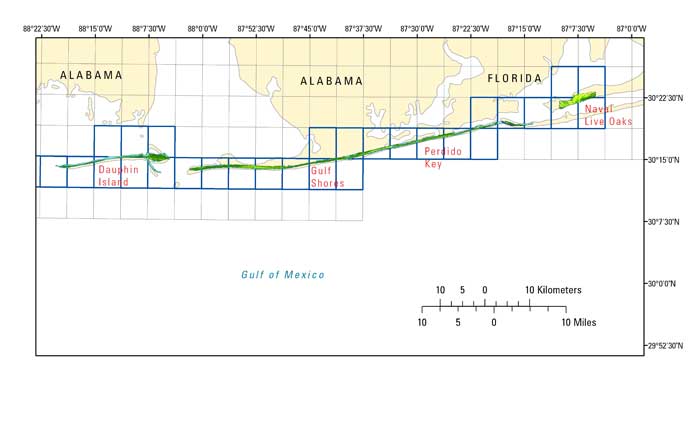
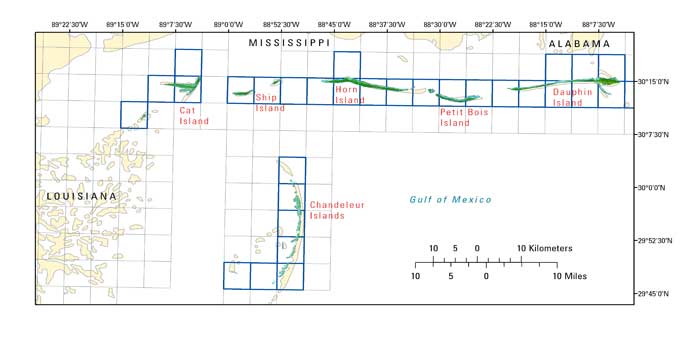
The purpose of this project was to produce a highly detailed and accurate first surface digital elevation map of the northern Gulf of Mexico barrier islands for use as a management tool and to make these data available to natural resource managers and research scientists.

How was the data set created?

  1. From what previous works were the data drawn?
    none (source 1 of 1)
    U.S. Geological Survey, 2008, EAARL Coastal Topography - Northern Gulf of Mexico, 2007: First surface: Data Series 399, U.S. Geological Survey, St. Petersburg.

    Type_of_Source_Media: Point elevation measurements collected by the EAARL sensor.
    Source_Contribution: unknown
  2. How were the data generated, processed, and modified?
    Date: 05-Aug-2008 (process 1 of 3)
    The data are collected using a Cessna 310 aircraft. The NASA Experimental Advanced Airborne Research Lidar (EAARL) laser scanner collects the data using a green (532 nm) raster scanning laser, while a digital camera acquires a visual record of the flight. The data are stored on hard drives and archived at the U.S. Geological Surveym office in St. Petersburg and the NASA office at Wallops Flight Facility. The navigational data are processed at Wallops Flight Facility. The navigational and unprocessed data are then downloaded into the Advanced Lidar Processing System (ALPS). Data are converted from units of time to x,y,z points for elevation. The derived surface data can then be converted into raster data (geoTIFFS). Person who carried out this activity:
    Jacobs Technology, U.S. Geological Survey, FISC, St. Petersburg
    Attn: Amar Nayegandhi
    Computer Scientist
    600 4th Street South
    Saint Petersburg, FL
    USA

    727-803-8747 (x3026) (voice)
    anayegandhi@usgs.gov
    Hours_of_Service: M-F, 8:00-5:00 EST
    Date: 24-Jan-2017 (process 2 of 3)
    Keywords section of metadata optimized for discovery in USGS Coastal and Marine Geology Data Catalog. Person who carried out this activity:
    U.S. Geological Survey
    Attn: Alan O. Allwardt
    Contractor -- Information Specialist
    2885 Mission Street
    Santa Cruz, CA

    831-460-7551 (voice)
    831-427-4748 (FAX)
    aallwardt@usgs.gov
    Date: 13-Oct-2020 (process 3 of 3)
    Added keywords section with USGS persistent identifier as theme keyword. Person who carried out this activity:
    U.S. Geological Survey
    Attn: VeeAnn A. Cross
    Marine Geologist
    384 Woods Hole Road
    Woods Hole, MA

    508-548-8700 x2251 (voice)
    508-457-2310 (FAX)
    vatnipp@usgs.gov
  3. What similar or related data should the user be aware of?
    Nayegandhi, A., Brock, J.C., Wright, C.W, 2009, Small footprint, waveform-resolving lidar estimation of submerged and sub-canopy topography in coastal environments: International Journal of Remote Sensing 30(4), p. 861-878, Taylor and Francis, London.

    Brock, J.C., Wright, C.W., Sallenger, A.H., Krabill, W.B., and Swift, R.N., 2002, Basis and methods of NASA Airborne Topographic Mapper lidar surveys for coastal studies: Journal of Coastal Research 18(1), p. 1-13, Coastal Research and Education Foundation, Inc., Florida.

    Sallenger, A.H., Wright, C.W., and Lillycrop, J., 2005, Coastal impacts of the 2004 hurricanes measured with airborne Lidar; initial results: Shore and Beach 73(2-3), p. 10-14.


How reliable are the data; what problems remain in the data set?

  1. How well have the observations been checked?
    The expected accuracy of the measured variables are as follows: attitude within 0.07 degree, 3 cm nominal laser ranging accuracy, and vertical elevation accuracy of +/-15 cm for the topographic surface. Quality checks are built into the data-processing software.
  2. How accurate are the geographic locations?
    Unprocessed elevation measurements have been determined to be within 1 meter horizontal accuracy.
  3. How accurate are the heights or depths?
    Elevations of the DEM are vertically consistent with the point elevation data, +/-15 cm.
  4. Where are the gaps in the data? What is missing?
    Several regions of the dataset are labeled as "No Data", which corresponds to a cell value of -32767 m in the GeoTIFF file. These "No Data" areas are a result of the survey not covering a particular region, optical water depth of greater than 1.5 Secchi disc depths, or the manual removal of lidar processing artifacts.
  5. How consistent are the relationships among the observations, including topology?
    Each file contains data located in USGS 24K Quarter-Quadrangle tile and are named after the USGS Alpha Quarter-Quad naming convention. AAOOOaoq, where AA is the positive whole number component of the latitude. OOO is the positive whole number component of the longitude (zero-padded to a width of 3); a is an alpha character a-h designating the quad in the degree of latitude; where a is closest to 0 minutes and h is closest to the next full degree. Each represents 1/8 of a degree; o is a numeral 1-8 designating the quad in the degree of longitude, where 1 is closest to 0 minutes and 8 is closest to the next full degree. Each represents 1/8 of a degree; q is an alpha character a-d designating which quarter in the quad, where a is SE, b is NE, c is NW, and d is SW. Each Quarter-Quad is 1/16 of a degree in latitude and 1/16 of a degree in longitude.

How can someone get a copy of the data set?

Are there legal restrictions on access or use of the data?
Access_Constraints: None
Use_Constraints:
The U.S. Geological Survey, National Park Service, and National Aeronautics and Space Administration request to be acknowledged as originators of this data in future products or derivative research.
  1. Who distributes the data set? (Distributor 1 of 1)
    U.S. Geological Survey
    Attn: Project Manager
    Project Manager
    600 4th Street South
    Saint Petersburg, FL
    USA

    727 803-8747 (voice)
    Hours_of_Service: M-F 8:30-5:00 EST
  2. What's the catalog number I need to order this data set? DS 399
  3. What legal disclaimers am I supposed to read?
    This DVD publication was prepared by an agency of the United States Government. Although these data have been processed successfully on a computer system at the U.S. Geological Survey, no warranty expressed or implied is made regarding the display or utility of the data on any other system, nor shall the act of distribution imply any such warranty. The U.S. Geological Survey shall not be held liable for improper or incorrect use of the data described and (or) contained herein. Reference herin to any specific commercial product, process, or service by trade name, trademark, manufacturer, or otherwise does not constitute or imply its endorsement, recommendation, or favoring by the United States Government or any agency thereof.
  4. How can I download or order the data?
    • Availability in digital form:
      Data format: TIFF (version 1.1) LAS
      Network links: http://pubs.usgs.gov/ds/399/data_files/fs/
      Media you can order: DVD (format DVD)
    • Cost to order the data: vary

    • Special instructions:
      Contact U.S. Geological Survey
    • How long will it take to get the data?
      vary
  5. Is there some other way to get the data?
    Contact U.S. Geological Survey for details

Who wrote the metadata?

Dates:
Last modified: 09-Nov-2021
Metadata author:
United States Geological Survey, St. Petersburg Coastal and Marine Science Center
Attn: SPCMSC Data Management Group
600 4th Street South
St. Petersburg, Florida
US

727-502-8000 (voice)
gs-g-spcmsc_data_inquiries@usgs.gov
Metadata standard:
Content Standard for Digital Geospatial Metadata (FGDC-STD-001-1998)

This page is <https://cmgds.marine.usgs.gov/catalog/spcmsc/ds-399metadata.faq.html>
Generated by mp version 2.9.50 on Tue Nov 9 16:47:42 2021