EAARL Coastal Topography--Assateague Island National Seashore, 2008: First Surface

Metadata also available as - [Outline] - [Parseable text] - [XML]

Frequently anticipated questions:


What does this data set describe?

Title:
EAARL Coastal Topography--Assateague Island National Seashore, 2008: First Surface
Abstract:
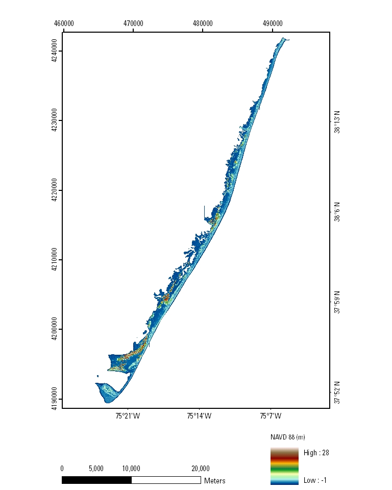
A first-surface elevation map (also known as a Digital Elevation Model, or DEM) of the Assateague Island National Seashore in Virginia and Maryland was produced from remotely sensed, geographically referenced elevation measurements cooperatively by the U.S. Geological Survey (USGS), the National Park Service (NPS), and the National Aeronautics and Space Administration (NASA). Elevation measurements were collected over the area using the NASA Experimental Advanced Airborne Research Lidar (EAARL), a pulsed laser ranging system mounted onboard an aircraft to measure ground elevation, vegetation canopy, and coastal topography. The system uses high frequency laser beams directed at the Earth's surface through an opening in the bottom of the aircraft's fuselage. The laser system records the time difference between emission of the laser beam and the reception of the reflected laser signal in the aircraft. The plane travels over the target area at approximately 50 meters per second at an elevation of approximately 300 meters. The EAARL, developed by NASA at Wallops Flight Facility in Virginia, measures ground elevation with a vertical resolution of +/-15 centimeters. A sampling rate of 3 kilohertz or higher results in an extremely dense spatial elevation dataset. Over 100 kilometers of coastline can be surveyed easily within a 3- to 4-hour mission. When subsequent elevation maps for an area are analyzed, they provide a useful tool to make management decisions regarding land development.
For more information on Lidar science and the Experimental Advanced Airborne Research Lidar (EAARL) system and surveys, see http://ngom.usgs.gov/dsp/overview/index.php and http://ngom.usgs.gov/dsp/tech/eaarl/index.php .
Supplemental_Information:
Raw lidar data are not in a format that is generally usable by resource managers and scientists for scientific analysis. Converting dense lidar elevation data into a readily usable format without loss of essential information requires specialized processing. The U.S. Geological Survey's Coastal and Marine Geology Program (CMGP) has developed custom software to convert raw lidar data into a GIS-compatible map product to be provided to GIS specialists, managers, and scientists. The primary tool used in the conversion process is Airborne Lidar Processing System (ALPS), a multi-tiered processing system developed by a USGS-NASA collaborative project. Specialized processing algorithms are used to convert raw waveform lidar data acquired by the EAARL to georeferenced spot (x,y,z) returns for "first surface" and "bare earth" topography. The zero crossing of the second derivative (i.e., detection of local maxima) is used to detect "first surface" topography, while the trailing edge algorithm (i.e., the algorithm searches for the location prior to the last return where direction changes along the trailing edge) is used to detect the range to the last return or "bare earth". Statistical filtering, known as the Random Consensus Filter (RCF), is used to remove false bottom returns and other outliers from the EAARL topography data. The filter uses a grid of non-overlapping square cells (buffer) of user-defined size overlaid onto the original point cloud. The user also defines the vertical tolerance (vertical width) based on the topographic complexity and point sampling density of the data. The maximum allowable elevation range within a cell is established by this vertical tolerance. An iterative process searches for the maximum concentration of points within the vertical tolerance, and removes those points outside of the tolerance (Nayegandhi and others, 2009). These data are then converted to the North American Datum of 1983 and the North American Vertical Datum of 1988 (using the GEOID03 model). Each file contains data located in a 2-kilometer by 2-kilometer tile, where the upper-left bound can be assessed quickly through the filename. The first 3 numbers in the filename represent the left-most UTM easting coordinate (e###000) in meters, the next 4 numbers represent the top-most UTM northing coordinate (n####000) in meters, and the last 2 numbers (##) represent the UTM zone in which the tile is located (for example, fs_e123_n4567_18).The development of custom software for creating these data products has been supported by the U.S. Geoloigcal Survey CMG Program's Decision Support for Coastal Parks, Sanctuaries, and Preserves Project. Processed data products are used by the U.S. Geoloigcal Survey CMG Program's National Assessments of Coastal Change Hazards Project to quantify the vulnerability of shorelines to coastal change hazards such as severe storms, sea-level rise, and shoreline erosion and retreat.
  1. How might this data set be cited?
    U.S. Geological Survey, 2009, EAARL Coastal Topography--Assateague Island National Seashore, 2008: First Surface: U.S. Geological Survey Data Series 446, U.S. Geological Survey, St. Petersburg, FL.

    Online Links:

  2. What geographic area does the data set cover?
    West_Bounding_Coordinate: -75.466667
    East_Bounding_Coordinate: -75
    North_Bounding_Coordinate: 38.33333
    South_Bounding_Coordinate: 37.75
  3. What does it look like?
    http://pubs.usgs.gov/ds/446/html/images/ASIS_fs_2mRes_mosaic.jpg (JPG)
    EAARL Coastal Topography–Assateague Island National Seashore, 2008: First Surface Mosaic: 2-meter Resolution
  4. Does the data set describe conditions during a particular time period?
    Calendar_Date: 24-Mar-2008
    Currentness_Reference:
    ground condition
  5. What is the general form of this data set?
    Geospatial_Data_Presentation_Form: remote-sensing image
  6. How does the data set represent geographic features?
    1. How are geographic features stored in the data set?
      Indirect_Spatial_Reference: Tiling Index
      This is a Raster data set. It contains the following raster data types:
      • Dimensions 2001 x 2001 x 1, type Pixel
    2. What coordinate system is used to represent geographic features?
      Grid_Coordinate_System_Name: Universal Transverse Mercator
      Universal_Transverse_Mercator:
      UTM_Zone_Number: 18
      Transverse_Mercator:
      Scale_Factor_at_Central_Meridian: 0.999600
      Longitude_of_Central_Meridian: -75.000000
      Latitude_of_Projection_Origin: 0
      False_Easting: 500000.000000
      False_Northing: 0
      Planar coordinates are encoded using row and column
      Abscissae (x-coordinates) are specified to the nearest 1.000000
      Ordinates (y-coordinates) are specified to the nearest 1.000000
      Planar coordinates are specified in meters
      The horizontal datum used is North American Datum of 1983.
      The ellipsoid used is Geodetic Reference System 80.
      The semi-major axis of the ellipsoid used is 6378137.000000.
      The flattening of the ellipsoid used is 1/298.257222.
      Vertical_Coordinate_System_Definition:
      Altitude_System_Definition:
      Altitude_Datum_Name: North American Vertical Datum of 1988
      Altitude_Resolution: 0.15 meters
      Altitude_Distance_Units: meters
      Altitude_Encoding_Method:
      Explicit elevation coordinate included with horizontal coordinates
  7. How does the data set describe geographic features?
    Entity_and_Attribute_Overview:
    Each pixel of the encoded GeoTIFF has an explicit elevation value associated with it. The GeoTIFF grid is encoded with a 1 meter resolution. The input parameters for the random consensus filter (RCF) were: grid cell size (buffer) = 6 meters x 6 meters; vertical tolerance (vertical width) = 1500 centimeters.
    Entity_and_Attribute_Detail_Citation:
    The variables measured by EAARL are distance between aircraft and GPS satellites (meters), attitude information (roll, pitch, heading in degrees), scan angle (degrees), second of the epoch (seconds), and 1-nanosecond time-resolved return intensity waveform (digital counts). Z value is referenced to orthometric elevations derived from National Geodetic Survey Geoid Model, GEOID03.

Who produced the data set?

  1. Who are the originators of the data set? (may include formal authors, digital compilers, and editors)
    • U.S. Geological Survey
  2. Who also contributed to the data set?
    Acknowledgment of the U.S. Geological Survey, Florida Integrated Science Center, as a data source would be appreciated in products developed from these data, and such acknowledgment as is standard for citation and legal practices for data source is expected. Sharing of new data layers developed directly from these data would also be appreciated by the U.S. Geological Survey staff. Users should be aware that comparisons with other datasets for the same area from other time periods may be inaccurate due to inconsistencies resulting from changes in photointerpretation, mapping conventions, and digital processes over time. These data are not legal documents and are not to be used as such.
  3. To whom should users address questions about the data?
    Amar Nayegandhi
    Jacobs Technology, U.S. Geological Survey, FISC, St. Petersburg, FL
    Computer Scientist
    600 4th Street South
    St. Petersburg, FL
    USA

    727 803-8747 (x3026) (voice)
    727-803-2031 (FAX)
    anayegandhi@usgs.gov
    Hours_of_Service: M-F, 8:00-5:00 EST

Why was the data set created?

The purpose of this project was to produce a highly detailed and accurate first-surface elevation map of the Assateague Island National Seashore in Virginia and Maryland for use as a management tool and to make these data available to natural-resource managers and research scientists.

How was the data set created?

  1. From what previous works were the data drawn?
  2. How were the data generated, processed, and modified?
    Date: 15-Sep-2008 (process 1 of 4)
    The data are collected using a Cessna 310 aircraft. The NASA Experimental Advanced Airborne Research Lidar (EAARL) laser scanner collects the data using a green (532-nanometers) raster scanning laser, while a digital camera acquires a visual record of the flight. The data are stored on hard drives and archived at the U.S. Geological Survey office in St. Petersburg, Florida and the NASA office at Wallops Flight Facility in Virginia. The navigational data are processed at Wallops Flight Facility. The navigational and raw data are then downloaded into the Airborne Lidar Processing System (ALPS). Data are converted from units of time to x,y,z points for elevation. The derived surface data can then be converted into raster data (GeoTIFFs). Person who carried out this activity:
    Amar Nayegandhi
    Jacobs Technology, U.S. Geological Survey, FISC, St. Petersburg, FL
    Computer Scientist
    600 4th Street South
    St. Petersburg, FL
    USA

    727-803-8747 (x3026) (voice)
    anayegandhi@usgs.gov
    Hours_of_Service: M-F, 8:00-5:00 EST
    Date: 15-Sep-2008 (process 2 of 4)
    Metadata imported into ArcCatalog from XML file. Person who carried out this activity:
    Xan Yates
    Jacobs Technology, U.S. Geological Survey, FISC, St. Petersburg, FL
    GIS/Image Analyst/Metadata Specialist
    600 4th Street South
    St. Petersburg, FL
    USA

    727-803-8747 (x3086) (voice)
    Hours_of_Service: M-F, 8:00-5:00 EST
    Date: 24-Jan-2017 (process 3 of 4)
    Keywords section of metadata optimized for discovery in USGS Coastal and Marine Geology Data Catalog. Person who carried out this activity:
    U.S. Geological Survey
    Attn: Alan O. Allwardt
    Contractor -- Information Specialist
    2885 Mission Street
    Santa Cruz, CA

    831-460-7551 (voice)
    831-427-4748 (FAX)
    aallwardt@usgs.gov
    Date: 13-Oct-2020 (process 4 of 4)
    Added keywords section with USGS persistent identifier as theme keyword. Person who carried out this activity:
    U.S. Geological Survey
    Attn: VeeAnn A. Cross
    Marine Geologist
    384 Woods Hole Road
    Woods Hole, MA

    508-548-8700 x2251 (voice)
    508-457-2310 (FAX)
    vatnipp@usgs.gov
  3. What similar or related data should the user be aware of?
    Nayeganshi, A., Brock, J.C., and Wright, C.W., 2009, Small footprint, waveform-resolving lidar estimation of submerged and subcanopy topography in coastal environments: International Journal of Remote Sensing 30(4), p. 861-878.


How reliable are the data; what problems remain in the data set?

  1. How well have the observations been checked?
    The expected accuracy of the measured variables is as follows: attitude within 0.07 degree, 3 centimeters nominal ranging accuracy, and vertical elevation accuracy of +/-15 centimeters for the topographic surface. Quality checks are built into the data-processing software.
  2. How accurate are the geographic locations?
    Raw elevation measurements have been determined to be within 1 meter in horizontal accuracy.
  3. How accurate are the heights or depths?
    Elevations are vertically consistent with the point elevation data, +/-15 centimeters.
  4. Where are the gaps in the data? What is missing?
    Several regions of the dataset are labeled as "No Data", which corresponds to a cell value of -32767 meters in the GeoTIFF file. These "No Data" areas are a result of the survey not covering a particular region, optical water depth of greater than 1.5 Secchi disc depths, or the manual removal of lidar processing artifacts. This metadata file is for example only and does not provide bounding coordinates for that reason.
  5. How consistent are the relationships among the observations, including topology?
    Each file contains data located in a 2-kilometer by 2-kilometer tile where the upper-left bound can be assessed quickly through the filename. The first 3 numbers in the filename represent the left-most UTM easting coordinate (e###000) in meters, the next 4 numbers represent the top-most UTM northing coordinate (n####000) in meters, and the last 2 numbers (##) represent the UTM zone in which the tile is located (for example, fs_e123_n4567_18).

How can someone get a copy of the data set?

Are there legal restrictions on access or use of the data?
Access_Constraints: None
Use_Constraints:
The U.S. Geological Survey, National Park Service, and National Aeronautics and Space Administration request to be acknowledged as originators of this data in future products or derivative research.
  1. Who distributes the data set? (Distributor 1 of 1)
    U.S. Geological Survey
    Attn: Amar Nayegandhi
    Project Manager
    600 4th Street South
    St. Petersburg, FL
    USA

    727-803-8747 (x3026) (voice)
    Hours_of_Service: M-F, 8:00-5:00 EST
  2. What's the catalog number I need to order this data set? DS 446
  3. What legal disclaimers am I supposed to read?
    This DVD publication was prepared by an agency of the United States Government. Although these data have been processed successfully on a computer system at the U.S. Geological Survey, no warranty expressed or implied is made regarding the display or utility of the data on any other system, nor shall the act of distribution imply any such warranty. The U.S. Geological Survey shall not be held liable for improper or incorrect use of the data described and (or) contained herein. Reference herein to any specific commercial product, process, or service by trade name, trademark, manufacturer, or otherwise does not constitute or imply its endorsement, recommendation, or favoring by the United States Government or any agency thereof.
  4. How can I download or order the data?
    • Availability in digital form:
      Data format: GeoTIFF (version 2) GeoTIFF
      Network links: http://pubs.usgs.gov/ds/446/data_files/fs/
      Media you can order: DVD (format DVD)
    • Cost to order the data: Vary

    • Special instructions:
      Contact U.S. Geological Survey.
    • How long will it take to get the data?
      Vary
  5. Is there some other way to get the data?
    Contact U.S. Geological Survey for details.

Who wrote the metadata?

Dates:
Last modified: 09-Nov-2021
Metadata author:
United States Geological Survey, St. Petersburg Coastal and Marine Science Center
Attn: SPCMSC Data Management Group
600 4th Street South
St. Petersburg, Florida
US

727-502-8000 (voice)
gs-g-spcmsc_data_inquiries@usgs.gov
Metadata standard:
Content Standard for Digital Geospatial Metadata (FGDC-STD-001-1998)

This page is <https://cmgds.marine.usgs.gov/catalog/spcmsc/ds-446metadata.faq.html>
Generated by mp version 2.9.50 on Tue Nov 9 16:47:42 2021