Citation:
Citation_Information:
Originator: U.S. Geological Survey
Publication_Date: 2010
Title:
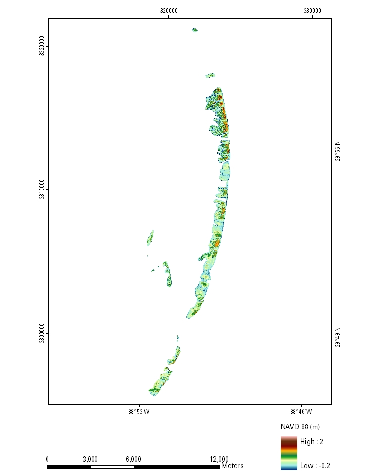
EAARL Coastal Topography--Chandeleur Islands, Louisiana, 2010: Bare Earth
Edition: first
Geospatial_Data_Presentation_Form: remote-sensing image
Series_Information:
Series_Name: U.S. Geological Survey Data Series
Issue_Identification: 511
Publication_Information:
Publication_Place: St. Petersburg, FL
Publisher: U.S. Geological Survey
Online_Linkage: http://pubs.usgs.gov/ds/511/
Description:
Abstract:
A bare-earth digital elevation map (also known as a Digital Elevation Model, or DEM) of a portion of the Chandeleur Islands, Louisiana, was produced from remotely sensed, geographically referenced elevation measurements cooperatively by the U.S. Geological Survey (USGS) and the National Aeronautics and Space Administration (NASA). Elevation measurements were collected over the area using the NASA Experimental Advanced Airborne Research Lidar (EAARL), a pulsed laser ranging system mounted onboard an aircraft to measure ground elevation, vegetation canopy, and coastal topography. The system uses high-frequency laser beams directed at the Earth's surface through an opening in the bottom of the aircraft's fuselage. The laser system records the time difference between emission of the laser beam and the reception of the reflected laser signal in the aircraft. The plane travels over the target area at approximately 50 meters per second at an elevation of approximately 300 meters. The EAARL, developed by NASA at Wallops Flight Facility in Virginia, measures ground elevation with a vertical resolution of +/-15 centimeters. A sampling rate of 3 kilohertz or higher results in an extremely dense spatial elevation dataset. Over 100 kilometers of coastline can be surveyed easily within a 3- to 4-hour mission. When subsequent elevation maps for an area are analyzed, they provide a useful tool to make management decisions regarding land development.
For more information on Lidar science and the Experimental Advanced Airborne Research Lidar (EAARL) system and surveys, see
http://ngom.usgs.gov/dsp/overview/index.php and
http://ngom.usgs.gov/dsp/tech/eaarl/index.php .
The purpose of this project was to produce highly detailed and accurate bare-earth digital elevation maps of a portion of the Chandeleur Islands, Louisiana, for use as a management tool and to make these data available to natural-resource managers and research scientists.
Supplemental_Information:
Raw lidar data are not in a format that is generally usable by resource managers and scientists for scientific analysis. Converting dense lidar elevation data into a readily usable format without loss of essential information requires specialized processing. The U.S. Geological Survey's Coastal and Marine Geology Program (CMGP) has developed custom software to convert raw lidar data into a GIS-compatible map product to be provided to GIS specialists, managers, and scientists. The primary tool used in the conversion process is Airborne Lidar Processing System (ALPS), a multi-tiered processing system developed by a USGS-NASA collaborative project. Specialized processing algorithms are used to convert raw waveform lidar data acquired by the EAARL to georeferenced spot (x,y,z) returns for "first surface" and "bare earth" topography. The zero crossing of the second derivative (that is, detection of local maxima) is used to detect "first surface" topography, while the trailing edge algorithm (that is, the algorithm searches for the location prior to the last return where direction changes along the trailing edge) is used to detect the range to the last return or "bare earth." Statistical filtering, known as the Random Consensus Filter (RCF), is used to remove false bottom returns and other outliers from the EAARL topography data. The filter uses a grid of non-overlapping square cells (buffer) of user-defined size overlaid onto the original point cloud. The user also defines the vertical tolerance (vertical width) based on the topographic complexity and point-sampling density of the data. The maximum allowable elevation range within a cell is established by this vertical tolerance. An iterative process searches for the maximum concentration of points within the vertical tolerance and removes those points outside of the tolerance (Nayegandhi and others, 2009). These data are then converted to the North American Datum of 1983 and the North American Vertical Datum of 1988 (using the GEOID09 model). Each file contains data located in a 2-kilometer by 2-kilometer tile, where the upper-left bound can be assessed quickly through the filename. The first 3 numbers in the filename represent the left-most UTM easting coordinate (e###000) in meters, the next 4 numbers represent the top-most UTM northing coordinate (n####000) in meters, and the last 2 numbers (##) represent the UTM zone in which the tile is located (for example, be_e123_n4567_16).The development of custom software for creating these data products has been supported by the U.S. Geological Survey CMG Program's Decision Support for Coastal Parks, Sanctuaries, and Preserves project. Processed data products are used by the U.S. Geological Survey CMG Program's National Assessments of Coastal Change Hazards project to quantify the vulnerability of shorelines to coastal change hazards such as severe storms, sea-level rise, and shoreline erosion and retreat.
Time_Period_of_Content:
Time_Period_Information:
Single_Date/Time:
Calendar_Date: 20100303
Currentness_Reference: ground condition
Status:
Progress: Complete
Maintenance_and_Update_Frequency: None planned
Spatial_Domain:
Bounding_Coordinates:
West_Bounding_Coordinate: -88.03706
East_Bounding_Coordinate: -88.79968
North_Bounding_Coordinate: 30.02491
South_Bounding_Coordinate: 29.76405
Keywords:
Theme:
Theme_Keyword_Thesaurus: USGS Metadata Identifier
Theme_Keyword: USGS:09b38fc6-ec08-4ee1-8435-acbdff6a0284
Theme:
Theme_Keyword_Thesaurus: ISO 19115 Topic Category
Theme_Keyword: elevation
Theme:
Theme_Keyword_Thesaurus: none
Theme_Keyword: Airborne Lidar Processing System
Theme_Keyword: ALPS
Theme_Keyword: Digital Elevation Model
Theme_Keyword: DEM
Theme_Keyword: EAARL
Theme_Keyword: Experimental Advanced Airborne Research Lidar
Theme_Keyword: laser altimetry
Theme_Keyword: lidar
Theme_Keyword: remote sensing
Theme_Keyword: topography
Theme:
Theme_Keyword_Thesaurus: Data Categories for Marine Planning
Theme_Keyword: distributions
Theme_Keyword: bathymetry and elevation
Theme:
Theme_Keyword_Thesaurus: Marine Realms Information Bank (MRIB) Keywords
Theme_Keyword: altimetry
Theme_Keyword: topographic mapping
Theme:
Theme_Keyword_Thesaurus: USGS Thesaurus
Theme_Keyword: LIDAR
Theme_Keyword: topography
Theme_Keyword: digital elevation models
Place:
Place_Keyword_Thesaurus: http://nationalmap.gov/
Place_Keyword: Chandeleur Islands
Place_Keyword: Northern Gulf of Mexico
Place_Keyword: Louisiana
Stratum:
Temporal:
Access_Constraints: None
Use_Constraints:
The U.S. Geological Survey and National Aeronautics and Space Administration request to be acknowledged as originators of these data in future products or derivative research.
Point_of_Contact:
Contact_Information:
Contact_Person_Primary:
Contact_Person: Amar Nayegandhi
Contact_Organization:
Jacobs Technology, U.S. Geological Survey, St. Petersburg Coastal and Marine Science Center, St. Petersburg, FL
Contact_Position: Computer Scientist
Contact_Address:
Address_Type: mailing and physical address
Address: 600 4th Street South
City: St. Petersburg
State_or_Province: FL
Postal_Code: 33701
Country: USA
Contact_Voice_Telephone: 727 803-8747 (x3026)
Contact_Facsimile_Telephone: 727 803-2031
Contact_Electronic_Mail_Address: [email protected]
Hours_of_Service: M-F, 9:00-5:00 EST
Browse_Graphic:
Data_Set_Credit:
Acknowledgment of the U.S. Geological Survey, St. Petersburg Coastal and Marine Science Center, as a data source would be appreciated in products developed from these data, and such acknowledgment as is standard for citation and legal practices for data source is expected. Sharing of new data layers developed directly from these data would also be appreciated by the U.S. Geological Survey staff. Users should be aware that comparisons with other datasets for the same area from other time periods may be inaccurate due to inconsistencies resulting from changes in photointerpretation, mapping conventions, and digital processes over time. These data are not legal documents and are not to be used as such.
Security_Information:
Security_Classification_System: Unclassified
Security_Classification: Unclassified
Security_Handling_Description: None
Native_Data_Set_Environment:
Microsoft Windows XP Version 5.1 (Build 2600) Service Pack 2; ESRI ArcCatalog 9.2.2.1350
Cross_Reference:
Citation_Information:
Originator: Nayegandhi, A., Brock, J.C., and Wright, C.W.
Publication_Date: 2009
Title:
Small footprint, waveform-resolving lidar estimation of submerged and subcanopy topography in coastal environments
Series_Information:
Series_Name: International Journal of Remote Sensing
Issue_Identification: 30(4), p. 861-878