Citation:
Citation_Information:
Originator: Arnell S. Forde
Originator: Shawn V. Dadisman
Originator: Jennifer L. Miselis
Originator: James G. Flocks
Originator: Dana S. Wiese
Publication_Date: 2013
Title:
Archive of Digital Chirp Subbottom Profile Data Collected During USGS Cruise 11BIM01 Offshore of the Chandeleur Islands, Louisiana, June 2011
Geospatial_Data_Presentation_Form: Archive for Subbottom Profile Data
Series_Information:
Series_Name: U.S. Geological Survey Data Series
Issue_Identification: 772
Publication_Information:
Publication_Place: St. Petersburg, FL
Publisher: U.S. Geological Survey
Online_Linkage: http://pubs.usgs.gov/ds/772/
Online_Linkage: http://cmgds.marine.usgs.gov/data/11BIM01/
Online_Linkage: http://pubs.usgs.gov/ds/772/software/arc/
Description:
Abstract:
In June of 2011, the U.S. Geological Survey conducted a geophysical survey offshore of the Chandeleur Islands, LA to investigate the geologic controls on barrier island framework. This report serves as an archive of unprocessed digital chirp subbottom data, trackline maps, navigation files, GIS information, and formal FGDC metadata. Gained digital images of the seismic profiles are also provided. The archived trace data are in standard Society of Exploration Geophysicists (SEG) SEG Y revision 0 format (Barry and others, 1975) and may be downloaded and processed with commercial or public domain software such as Seismic Unix (SU). Example SU processing scripts and USGS software for viewing the SEG Y files (Zihlman, 1992) are also provided.
These data are also available for viewing using GeoMapApp (
http://www.geomapapp.org/) and Virtual Ocean (
http://www.virtualocean.org/) multi-platform open source software. In addition, the SEG Y files can also be downloaded from the USGS Coastal and Marine Geoscience Data System (
http://cmgds.marine.usgs.gov)
To archive all digital chirp subbottom profile data and associated files collected during cruise 11BIM01.
Supplemental_Information:
The USGS Saint Petersburg Coastal and Marine Science Center (SPCMSC) - St. Petersburg, FL, assigns a unique identifier to each cruise or field activity. For example, 11BIM01 tells us the data were collected in 2011 during the first field activity for that project in that calendar year. Refer to
http://walrus.wr.usgs.gov/infobank/programs/html/definition/activity.html for a detailed description of the method used to assign the cruise ID. The naming convention used for each subbottom line is as follows: yye##a, where 'yy' are the last two digits of the year in which the data were collected, 'e' is a 1-letter abbreviation for the equipment type (for example, c for 424 chirp), '##' is a 2-digit number representing a specific track, and 'a' is a letter representing the section of a line if recording was prematurely terminated or rerun for quality or acquisition problems.All Chirp systems use a signal of continuously varying frequency; the system used during this survey produces high-resolution, shallow-penetration (typically less than 50-ms) profile images of sub-seafloor stratrigraphy. The towfish contains a transducer that transmits and receives acoustic energy and is typically towed 1 - 2 m below the sea surface. As transmitted acoustic energy intersects density boundaries, such as the seafloor or sub-surface sediment layers, some energy is reflected back toward the transducer, received, and recorded by a PC-based seismic acquisition system. This process is repeated at regular time intervals (for example, 0.125 s) and returned energy is recorded for a specific duration (for example, 50 ms). In this way, a two-dimensional (2-D) vertical image of the shallow geologic structure beneath the towfish is produced.The seismic source utilized during 11BIM01 consisted of an EdgeTech SB-424 towfish running DISCOVER v. 3.51 acquisition software and towed about 2 m behind the GPS antenna. The data were acquired using a frequency sweep that varied between 4 - 24 kHz; 4 - 20 kHz and 4 - 16 kHz, a 43 kHz sample frequency, and approximately 75 ms record length. Based on survey speeds of 3.5 knots, the shot spacing was about 0.450 m.The binary portion of the unprocessed seismic data are stored in SEG Y rev. 0 (Barry and others, 1975), IBM float format, which is a standard digital format that can be read and manipulated by most seismic processing software packages; the first 3,200 bytes of the file header are in ASCII format instead of EBCDIC format. The SEG Y formatted trace files have a .sgy extension. The SEG Y files may be downloaded and processed with commercial or public domain software such as Seismic Unix (SU) (Cohen and Stockwell, 2010). Also provided are example SU scripts that allow the user to strip off navigation fixes from the SEG Y headers, along with a fix for every 1,000 shots, and produce a printable, gained GIF image of each profile. The printable profiles provided here are GIF images that were gained using SU software. Refer to the Software page for links to example SU processing scripts and USGS software for viewing the SEG Y files (Zihlman, 1992).
Time_Period_of_Content:
Time_Period_Information:
Range_of_Dates/Times:
Beginning_Date: 20110603
Ending_Date: 20110613
Currentness_Reference: Data collection interval
Status:
Progress: Complete
Maintenance_and_Update_Frequency: None planned
Spatial_Domain:
Bounding_Coordinates:
West_Bounding_Coordinate: -88.920242
East_Bounding_Coordinate: -88.788672
North_Bounding_Coordinate: 30.101264
South_Bounding_Coordinate: 29.871811
Keywords:
Theme:
Theme_Keyword_Thesaurus: USGS Metadata Identifier
Theme_Keyword: USGS:83ab2ec2-1f09-4180-aa32-94cbc84cf0b0
Theme:
Theme_Keyword_Thesaurus: ISO 19115 Topic Category
Theme_Keyword: geoscientificinformation
Theme_Keyword: oceans
Theme:
Theme_Keyword_Thesaurus: General
Theme_Keyword: Geology
Theme_Keyword: Coastal information
Theme_Keyword: Marine
Theme_Keyword: Subbottom profile
Theme_Keyword: Seismic reflection
Theme_Keyword: Chirp
Theme_Keyword: Society of Exploration Geophysicists
Theme_Keyword: SEG Y
Theme_Keyword: Barrier Island Mapping
Theme_Keyword: 11BIM01
Theme:
Theme_Keyword_Thesaurus: Data Categories for Marine Planning
Theme_Keyword: distributions
Theme_Keyword: substrate
Theme:
Theme_Keyword_Thesaurus: Marine Realms Information Bank (MRIB) Keywords
Theme_Keyword: seismic reflection
Theme_Keyword: marine geophysics
Theme:
Theme_Keyword_Thesaurus: USGS Thesaurus
Theme_Keyword: seismic reflection methods
Theme_Keyword: sub-bottom profiling
Theme_Keyword: marine geophysics
Place:
Place_Keyword_Thesaurus: Geographic Names Information System (GNIS) Content
Place_Keyword: United States of America
Place_Keyword: Louisiana
Place_Keyword: Gulf of Mexico
Place_Keyword: Chandeleur Islands
Access_Constraints: None. These data are held in the public domain.
Use_Constraints:
The U.S. Geological Survey requests to be acknowledged as originator of the data in future products or derivative research.
Point_of_Contact:
Contact_Information:
Contact_Person_Primary:
Contact_Person: Arnell S. Forde
Contact_Organization: U.S. Geological Survey
Contact_Position: Geologist
Contact_Address:
Address_Type: mailing and physical
Address: 600 4th Street South
City: Saint Petersburg
State_or_Province: FL
Postal_Code: 33701
Country: USA
Contact_Voice_Telephone: (727) 803-8747 ext. 3111
Contact_Electronic_Mail_Address: [email protected]
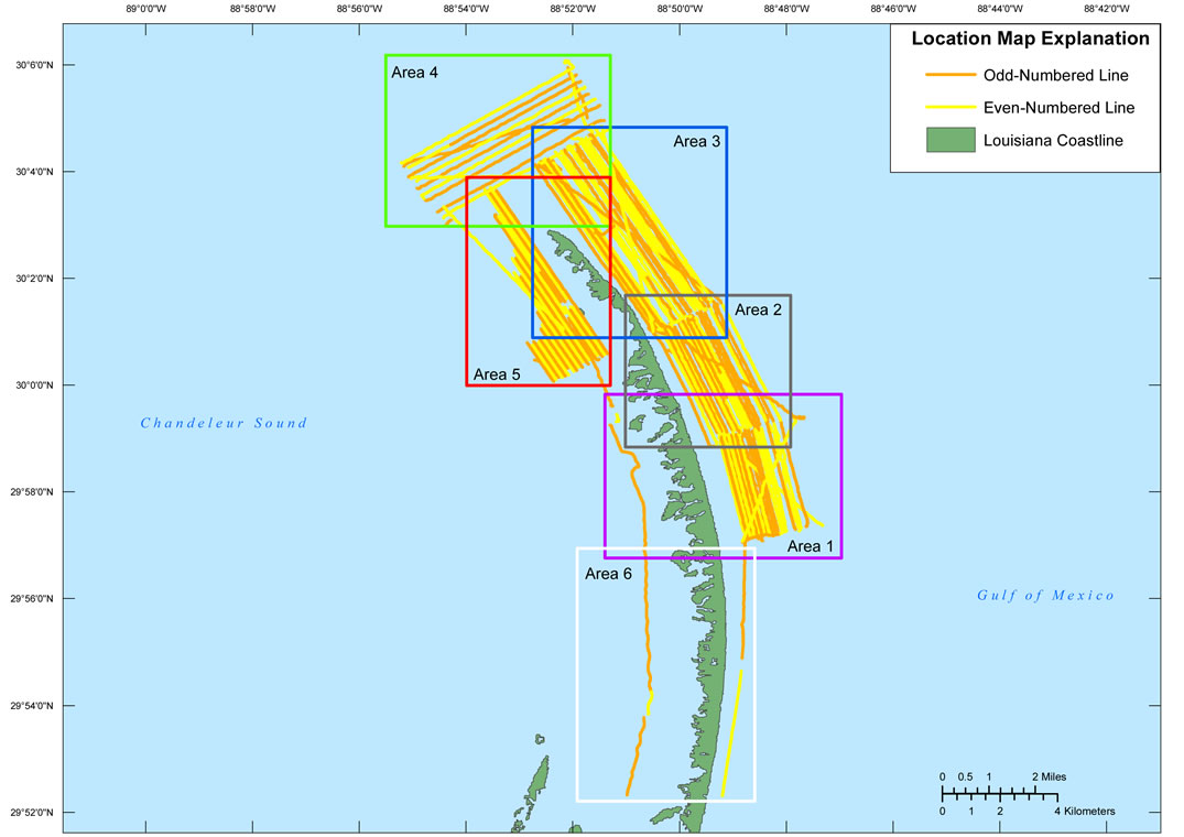
Browse_Graphic:
Browse_Graphic_File_Name: http://pubs.usgs.gov/ds/772/maps/11bim01_location.jpg
Browse_Graphic_File_Description:
Location map (fig. 1) of all digital chirp subbottom data collected during USGS Field Activity 11BIM01. This map was created at a scale of 1:157,950.
Browse_Graphic_File_Type: JPEG
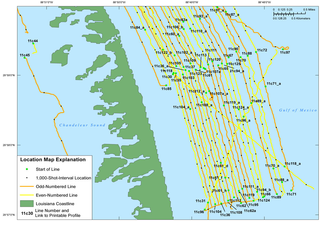
Browse_Graphic:
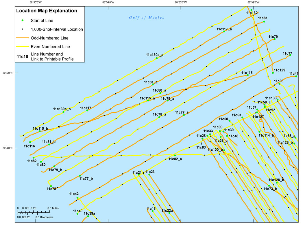
Browse_Graphic_File_Name: http://pubs.usgs.gov/ds/772/maps/11bim01_area1.jpg
Browse_Graphic_File_Description:
Detailed trackline map (fig.3) of digital chirp subbottom data collected during USGS Field Activity 11BIM01. This map was created at a scale of 1:27,950.
Browse_Graphic_File_Type: JPEG
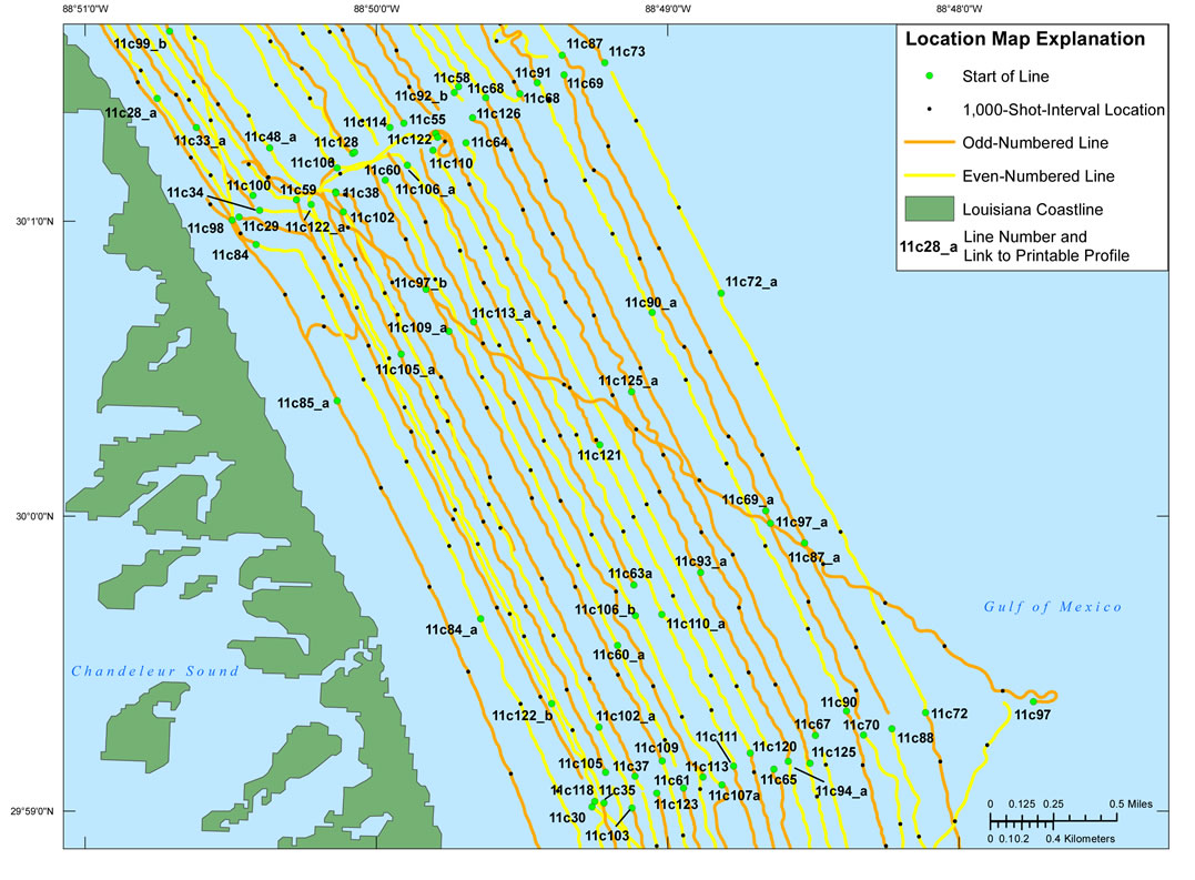
Browse_Graphic:
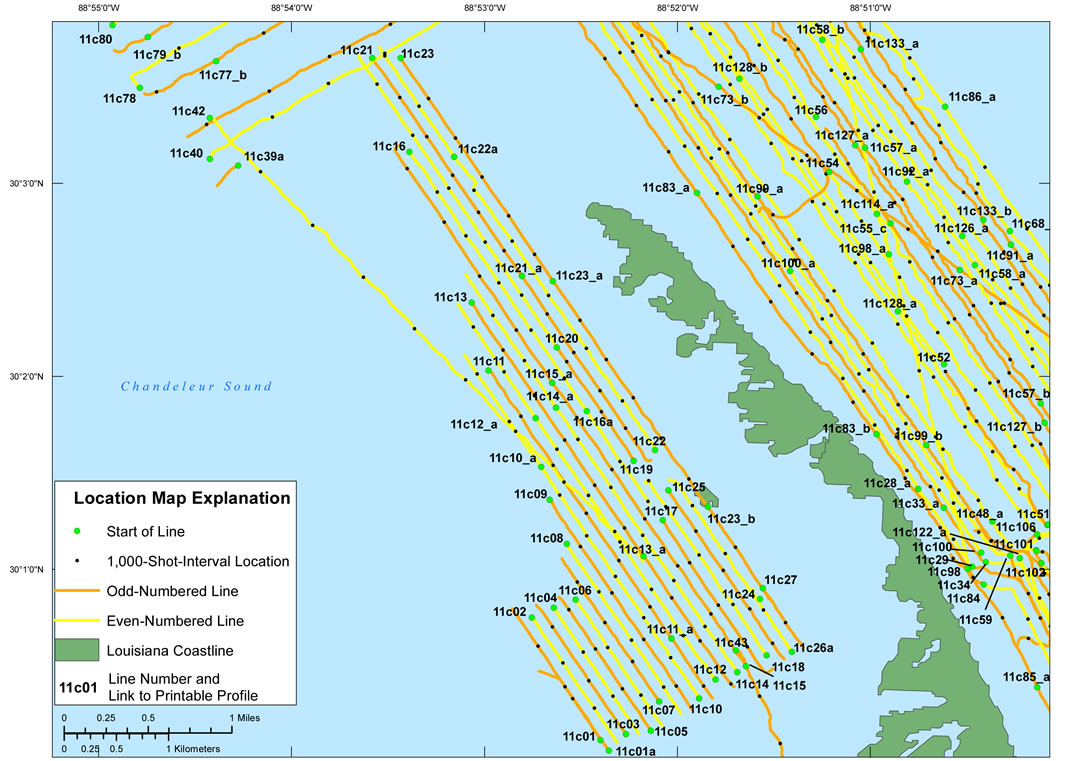
Browse_Graphic_File_Name: http://pubs.usgs.gov/ds/772/maps/11bim01_area2.jpg
Browse_Graphic_File_Description:
Detailed trackline map (fig.4) of digital chirp subbottom data collected during USGS Field Activity 11BIM01. This map was created at a scale of 1:24,000.
Browse_Graphic_File_Type: JPEG
Browse_Graphic:
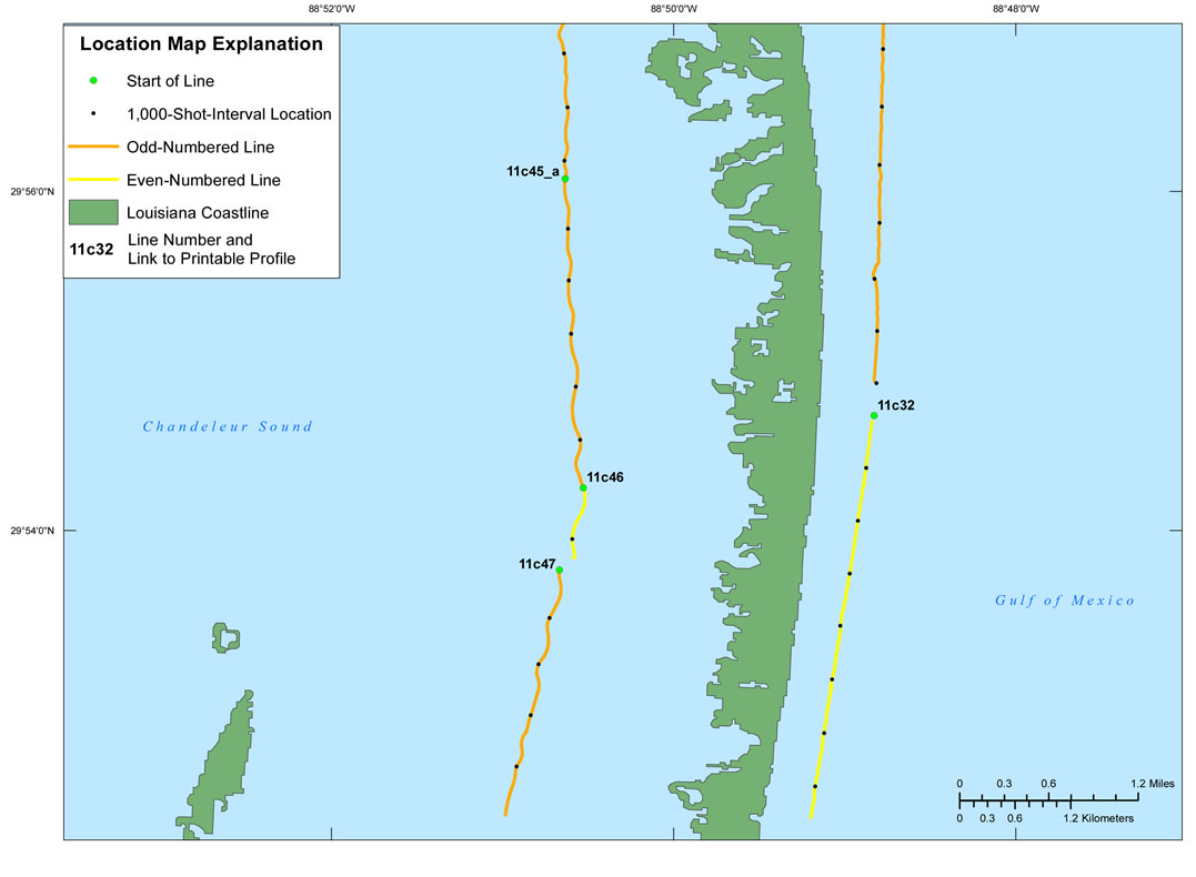
Browse_Graphic_File_Name: http://pubs.usgs.gov/ds/772/maps/11bim01_area3.jpg
Browse_Graphic_File_Description:
Detailed trackline map (fig.5) of digital chirp subbottom data collected during USGS Field Activity 11BIM01. This map was created at a scale of 1:30,000.
Browse_Graphic_File_Type: JPEG
Browse_Graphic:
Browse_Graphic_File_Name: http://pubs.usgs.gov/ds/772/maps/11bim01_area4.jpg
Browse_Graphic_File_Description:
Detailed trackline map (fig.6) of digital chirp subbottom data collected during USGS Field Activity 11BIM01. This map was created at a scale of 1:30,000.
Browse_Graphic_File_Type: JPEG
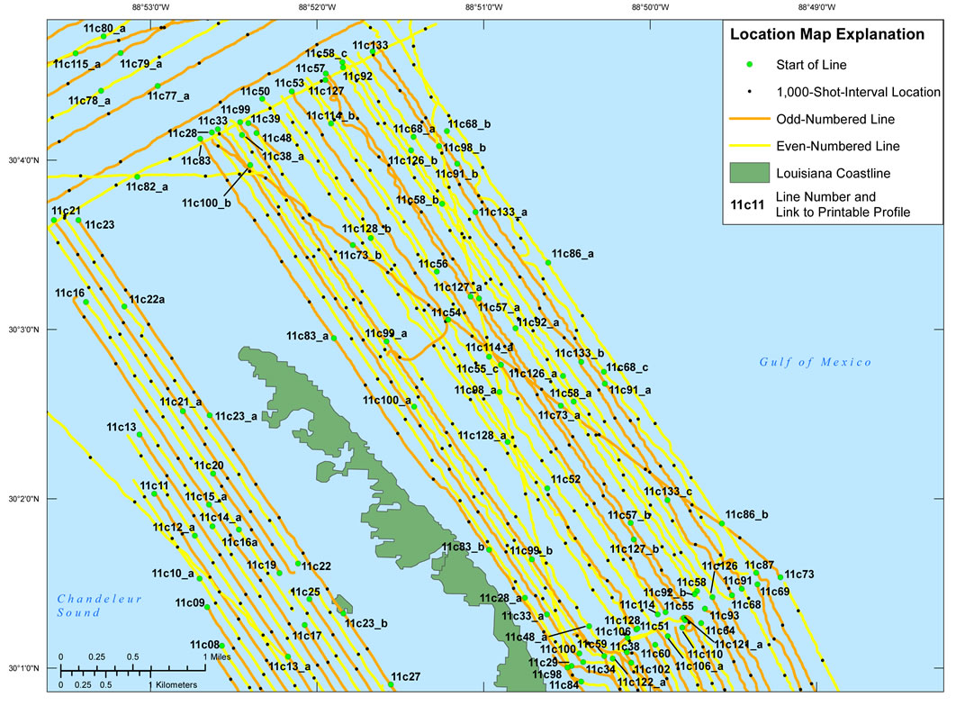
Browse_Graphic:
Browse_Graphic_File_Name: http://pubs.usgs.gov/ds/772/maps/11bim01_area5.jpg
Browse_Graphic_File_Description:
Detailed trackline map (fig.7) of digital chirp subbottom data collected during USGS Field Activity 11BIM01. This map was created at a scale of 1:29,500.
Browse_Graphic_File_Type: JPEG
Browse_Graphic:
Browse_Graphic_File_Name: http://pubs.usgs.gov/ds/772/maps/11bim01_area6.jpg
Browse_Graphic_File_Description:
Detailed trackline map (fig.8) of digital chirp subbottom data collected during USGS Field Activity 11BIM01. This map was created at a scale of 1:79,500.
Browse_Graphic_File_Type: JPEG
Browse_Graphic:
Data_Set_Credit:
Funding and (or) support for this study was provided by the USGS Coastal and Marine Geology Program. We thank R/V Survey Cat captain Nancy DeWitt (SPCMSC) for her assistance in data collection and Will Pfeiffer and Noreen Buster for their assistance with swath data processing. This document was improved by the reviews Paul Knorr and Kyle Kelso of the USGS - St. Petersburg, FL.Disc Image Credit: Schmaltz, Jeff, MODIS Rapid Response Team at the NASA Goddard Space Flight Center, 2004, UnitedStates.A2004106.1855.500m.jpg. Also available on-line at
http://eoimages.gsfc.nasa.gov/ve/6886/UnitedStates.A2004106.1855.500m.jpg
Citation_Information:
Originator: Cohen, J.K., and Stockwell, J.W., Jr., CWP/SU
Publication_Date: 2010
Title:
Seismic Unix Release 41: A free package for seismic research and processing, Center for Wave Phenomena, Colorado School of Mines
Online_Linkage: http://www.cwp.mines.edu/cwpcodes/index.html
Cross_Reference:
Citation_Information:
Originator: Zihlman, F.N., USGS
Publication_Date: 1992
Title:
DUMPSEGY V1.0: A program to examine the contents of SEG Y disk-image seismic data
Series_Information:
Series_Name: U.S. Geological Survey Open-File Report
Issue_Identification: 92-590
Other_Citation_Details: 28 pages
Online_Linkage: http://pubs.er.usgs.gov/usgspubs/ofr/ofr92590
Cross_Reference:
Citation_Information:
Originator: Barry, K.M., Cavers, D.A., and Kneale, C.W.
Publication_Date: 1975
Title: Recommended standards for digital tape formats
Series_Information:
Series_Name: Geophysics
Issue_Identification: v. 40, no. 2
Other_Citation_Details: pages 344-352
Online_Linkage: http://www.seg.org/publications/tech-stand/