Post-Hurricane Katrina coastal oblique aerial photographs collected from Panama City, Florida, to Lakeshore, Mississippi, and the Chandeleur Islands, Louisiana, August 31, 2005

Metadata also available as - [Questions & Answers] - [Parseable text] - [XML]

Metadata:

Identification_Information:
Citation:
Citation_Information:
Originator: Karen L.M. Morgan
Originator: Nancy Dewitt
Publication_Date: 2017
Title:
Post-Hurricane Katrina coastal oblique aerial photographs collected from Panama City, Florida, to Lakeshore, Mississippi, and the Chandeleur Islands, Louisiana, August 31, 2005
Geospatial_Data_Presentation_Form:
Multimedia presentation of JPEG images and point data in ASCII and CSV files
Series_Information:
Series_Name: U.S. Geological Survey Data Series
Issue_Identification: Data Series 1033
Publication_Information:
Publication_Place: St. Petersburg, Fla.
Publisher: U.S. Geological Survey
Other_Citation_Details: None
Online_Linkage: https://doi.org/10.3133/ds1033
Description:
Abstract:
The U.S. Geological Survey (USGS), as part of the National Assessment of Coastal Change Hazards project, conducts baseline and storm-response photography missions to document and understand the changes in vulnerability of the Nation's coasts to extreme storms. On August 31, 2005, the USGS conducted an oblique aerial photographic survey from Panama City, Florida, to Lakeshore, Mississippi, and the Chandeleur Islands, Louisiana, aboard a Piper Navajo Chieftain aircraft at an altitude of 500 feet (ft) and approximately 1,000 ft offshore (figure 2, http://pubs.usgs.gov/ds/1033/html/ds1033_fig2.html). This mission was conducted to collect data for assessing incremental changes in the beach and nearshore area since the last survey, flown in July 2001 (http://cmgds.marine.usgs.gov/fan_info.php?fan=01ACH02) (unpublished), and the data can be used to assess future coastal change. The photographs provided are Joint Photographic Experts Group (JPEG) images. The photograph locations are an estimate of the position of the aircraft and do not indicate the location of the feature in the images (See the Navigation Data page, http://pubs.usgs.gov/ds/1033/html/ds1033_nav.html). These photographs document the configuration of the barrier islands and other coastal features at the time of the survey. ExifTool was used to add the following to the header of each photo: time of collection, Global Positioning System (GPS) latitude, GPS longitude, keywords, credit, artist (photographer), caption, copyright, and contact information. Photographs can be opened directly with any JPEG-compatible image viewer by clicking on a thumbnail on the contact sheet. All image times are recorded in Coordinated Universal Time (UTC). Table 1 (http://pubs.usgs.gov/ds/1033/html/ds1033_table.html) provides detailed information about the assigned location, name, date, and time the photograph was taken along with links to the photograph. In addition to the photographs, a Google Earth Keyhole Markup Language (KML) file is provided and can be used to view the images by clicking on the marker and then clicking on either the thumbnail or the link above the thumbnail. The KML files were created using the photographic navigation files. Note: A KML number was assigned to each photograph to aid navigation of the Google Earth file. These numbers correspond to the site labels in Google Earth.
Purpose:
To provide access to digital photographs taken as part of the August 31, 2005, Post-Hurricane Katrina oblique aerial survey collected along the coast, from Panama City, Florida, to Lakeshore, Mississippi, and the Chandeleur Islands, Louisiana, and to provide access to attribute data that documents the time and location of where each photograph was taken.
Supplemental_Information:
For a summary of field activity 05CCH02 please see http://cmgds.marine.usgs.gov/fan_info.php?fan=05CCH02. Bounding coordinates for the oblique aerial survey are derived from the overall flight path found in the raw GPS data. Ancillary files included in this publication are ds1033_05CCH02.csv, ds1033_05CCH02_0831_plgrgov.txt, and ds1033_05CCH02.kml, in addition to the digitized oblique aerial image files.
Time_Period_of_Content:
Time_Period_Information:
Range_of_Dates/Times:
Beginning_Date: 20050831
Beginning_Time: 135218
Ending_Date: 20050831
Ending_Time: 222428
Currentness_Reference: ground condition
Status:
Progress: Complete
Maintenance_and_Update_Frequency: as needed
Spatial_Domain:
Bounding_Coordinates:
West_Bounding_Coordinate: -89.44400
East_Bounding_Coordinate: -84.87700
North_Bounding_Coordinate: 30.68301
South_Bounding_Coordinate: 29.77257
Keywords:
Theme:
Theme_Keyword_Thesaurus: USGS Metadata Identifier
Theme_Keyword: USGS:7aeb338f-bf8d-4c67-a87d-71feaaaaf9a6
Theme:
Theme_Keyword_Thesaurus: General
Theme_Keyword: U.S. Geological Survey
Theme_Keyword: National Assessment for Coastal Change Hazards
Theme_Keyword: photographs
Theme_Keyword: coastline
Theme_Keyword: beach erosion
Theme_Keyword: Coastal Oblique Aerial Photography
Theme_Keyword: Post-Hurricane Katrina
Theme_Keyword: Katrina
Theme_Keyword: Post-Storm
Theme:
Theme_Keyword_Thesaurus: ISO 19115 Topic Category
Theme_Keyword: environment
Theme_Keyword: imageryBaseMapsEarthCover
Theme_Keyword: structure
Place:
Place_Keyword_Thesaurus: Geographic Names Information Service (GNIS)
Place_Keyword: Chandeleur Islands
Place_Keyword: Louisiana
Place_Keyword: Florida
Place_Keyword: Alabama
Place_Keyword: Mississippi
Place_Keyword: Mississippi Barrier Islands
Place_Keyword: Mississippi Mainland
Place_Keyword: Alabama Barrier Islands
Place_Keyword: Florida Barrier Islands
Place_Keyword: Dauphin Island
Place_Keyword: Petit Bois Island
Place_Keyword: Horn Island
Place_Keyword: Ship Island
Place_Keyword: Cat Island
Place_Keyword: Northern Gulf of Mexico
Temporal:
Temporal_Keyword_Thesaurus: General
Temporal_Keyword: 2005
Access_Constraints: None
Use_Constraints:
The U.S. Geological Survey requests to be acknowledged as the originator of the data in future products or derivative research.
Point_of_Contact:
Contact_Information:
Contact_Person_Primary:
Contact_Person: K. Morgan
Contact_Organization: USGS
Contact_Position: Geologist
Contact_Address:
Address_Type: Physical and Mailing
Address: 600 4th Street South
City: St. Petersburg
State_or_Province: FL
Postal_Code: 33701
Country: USA
Contact_Voice_Telephone: (727) 502-8037
Contact_Electronic_Mail_Address: kmorgan@usgs.gov
Browse_Graphic:
Browse_Graphic_File_Name: http://pubs.usgs.gov/ds/1033/downloads/maps/index.jpg
Browse_Graphic_File_Description:
Index map of survey area flight path during USGS field activity 05CCH02. Red line shows the storm track (provided by Unisys Weather).
Browse_Graphic_File_Type: JPG
Browse_Graphic:
Browse_Graphic_File_Name: http://pubs.usgs.gov/ds/1033/html/html_images/fig2.jpg
Browse_Graphic_File_Description:
Graphic of acquisition geometry (Figure 2) for USGS field activity 05CCH02. Graphic shows basic flight distance from the shore and elevation during the survey for the aircraft used.
Browse_Graphic_File_Type: JPG
Browse_Graphic:
Browse_Graphic_File_Name: http://pubs.usgs.gov/ds/1033/downloads/maps/05CCH02_1.jpg
Browse_Graphic_File_Description:
Map showing the extent of Area 1 for the Post-Hurricane Katrina coastal oblique aerial photographs from Panama City, Florida, to Pensacola Beach, Florida. The flight path, divided into 5-minute segments, is represented by the alternating purple and yellow lines. Pages containing thumbnail images of photographs, referred to as contact sheets, were created based on these segments.
Browse_Graphic_File_Type: JPG
Browse_Graphic:
Browse_Graphic_File_Name: http://pubs.usgs.gov/ds/1033/downloads/maps/05CCH02_2.jpg
Browse_Graphic_File_Description:
Map showing the extent of Area 2 for the Post-Hurricane Katrina coastal oblique aerial photographs from Pensacola Beach, Florida, to Ship Island, Mississippi. The flight path, divided into 5-minute segments, is represented by the alternating purple and yellow lines. Pages containing thumbnail images of photographs, referred to as contact sheets, were created based on these segments.
Browse_Graphic_File_Type: JPG
Browse_Graphic:
Browse_Graphic_File_Name: http://pubs.usgs.gov/ds/1033/downloads/maps/05CCH02_3.jpg
Browse_Graphic_File_Description:
Map showing the extent of Area 3 for the Post-Hurricane Katrina coastal oblique aerial photographs from Cat Island, Mississippi, to the Chandeleur Islands, Louisiana. The flight path, divided into 5-minute segments, is represented by the alternating purple and yellow lines. Pages containing thumbnail images of photographs, referred to as contact sheets, were created based on these segments.
Browse_Graphic_File_Type: JPG
Browse_Graphic:
Browse_Graphic_File_Name: http://pubs.usgs.gov/ds/1033/downloads/maps/05CCH02_4.jpg
Browse_Graphic_File_Description:
Map showing the extent of Area 4 for the Post-Hurricane Katrina coastal oblique aerial photographs from Coden, Alabama, to Lakeshore, Mississippi. The flight path, divided into 5-minute segments, is represented by the alternating purple and yellow lines. Pages containing thumbnail images of photographs, referred to as contact sheets, were created based on these segments.
Browse_Graphic_File_Type: JPG
Browse_Graphic:
Browse_Graphic_File_Name: http://pubs.usgs.gov/ds/1033/downloads/maps/inset04_navarre.jpg
Browse_Graphic_File_Description:
Inset map showing the extent of inset04_navarre.jpg for the Post-Hurricane Katrina coastal oblique aerial photographs the Navarre Beach Marine Park, Navarre, Florida, to the Gulf Islands National Seashore, Florida. The flight path, divided up into 5-minute segments, is represented by the alternating purple and yellow lines. Pages containing thumbnail images of photographs, referred to as contact sheets, were created based on these segments.
Browse_Graphic_File_Type: JPG
Browse_Graphic:
Browse_Graphic_File_Name: http://pubs.usgs.gov/ds/1033/downloads/maps/inset05_dauphin.jpg
Browse_Graphic_File_Description:
Inset map showing the extent of inset05_dauphin.jpg for the Post-Hurricane Katrina coastal oblique aerial photographs Dauphin Island, Alabama. The flight path, divided up into 5-minute segments, is represented by the alternating purple and yellow lines. Pages containing thumbnail images of photographs, referred to as contact sheets, were created based on these segments.
Browse_Graphic_File_Type: JPG
Data_Set_Credit:
Funding and (or) support for this study was provided by the USGS Coastal and Marine Geology Program (CMGP). The authors wish to thank pilot, Paul Plenarski, for his assistance in data collection. This report benefited from the comments and reviews of Kara Doran and Julie Bernier with the USGS St. Petersburg Coastal and Marine Science Center (SPCMSC), St. Petersburg, Fla.
Data_Quality_Information:
Attribute_Accuracy:
Attribute_Accuracy_Report:
An attempt was made to set the cameras to UTC time on the GPS receivers at the beginning of each flight. The clock of the Compix Titler unit was also set to UTC at the same time. Human error during transcription of geographic position and time from the video is possible; however, no obvious errors were observed. Latitude, longitude, and time were linearly interpolated from known navigation (collected once every 30 seconds) and time stamps (collected once every minute). NOTE: Latitude and longitude positions in this report refer to the position of the aircraft, not the position of the landmarks photographed. Refer to the Process Steps below for more detail.
Logical_Consistency_Report:
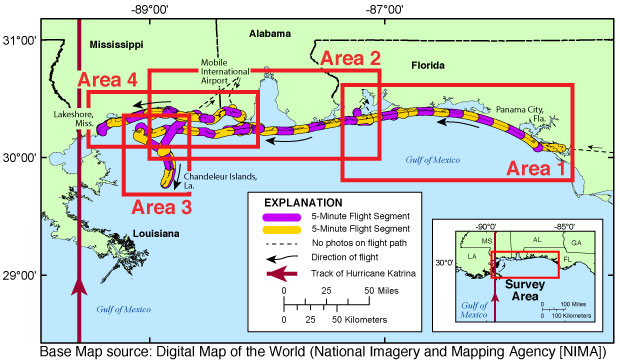
Data presented here include the digitally scanned analog and digitally collected photographs in JPEG format with the Exchangeable Image File (EXIF) header embedded with the individual photograph's location along the flight path of the Post-Hurricane Katrina coastal oblique aerial photographic survey of the coast, from Panama City, Florida, to Lakeshore, Mississippi, and the Chandeleur Islands, Louisiana. This mission was flown on August 31, 2005, aboard a Piper Navajo Chieftain, tail number N2KK. Crew members of the USGS in St. Petersburg, Fla., included Karen L. M. Morgan, M. Dennis Krohn, Phillip Thompson, and Nancy Dewitt, and pilot Paul Plenarski of Bay Air Charters, Inc. Still photography was collected along the coast during this survey. GPS Data Collection: Instrument: Trimble Centurion and Rockwell Collins Precision Lightweight Global Positioning System Receiver (PLGR), Data Collection Interval: 30 Seconds, Data File Format: Text, Number of files created: 1, Trimble data: recorded on video tape, PLGR data: text file, Computer/Software Used: none. The GPS units were used to record navigation fixes of the aircraft, not the position of the features imaged. Video collected during this flight is not included in this report. For a summary of field activity 05CCH02 please see http://cmgds.marine.usgs.gov/fan_info.php?fan=05CCH02.
Completeness_Report: no known issues
Positional_Accuracy:
Horizontal_Positional_Accuracy:
Horizontal_Positional_Accuracy_Report:
An attempt was made to maintain the same relative distance between the aircraft and the beach in order to keep a constant field of view.
Quantitative_Horizontal_Positional_Accuracy_Assessment:
Horizontal_Positional_Accuracy_Value: 100 feet
Horizontal_Positional_Accuracy_Explanation:
Based on manufacturer specifications when available. The GPS receiver used to provide navigation to the video titler unit was a Trimble Centurion, which is accurate to within 100 feet. Independent of all other equipment, a Rockwell Collins Precision Lightweight Global Positioning System Receiver unit, also accurate to within about 100 feet, recorded navigation fixes. An attempt was made to maintain the same relative distance between the aircraft and the beach in order to keep a constant field of view. The GPS receiver used to provide navigation to the video titler unit was a Trimble Centurion, which is accurate to within 100 feet.
Lineage:
Process_Step:
Process_Description:
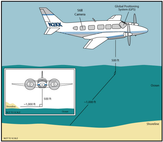
Image Acquisition: Photographs were taken with two Nikon F3 cameras, each with a fixed 50-millimeter lens and a Skylight filter. One camera shot the odd-numbered film rolls, and the other camera shot the even-numbered rolls. Both cameras were equipped with a Nikon MF-14 data back. Rolls were numbered by hand in the air. Film used was Kodak Ektachrome E100G. Commonly used shutter speeds were 1/250 seconds or 1/125 seconds. A constant shutter speed was attempted but may have veried if there was a noticeable change in light levels. The f-stop was changed to compensate for changes in light levels. The Nikon MF-14 data back added day of the month, hour, and minute (UTC) to the lower right-hand corner of the photo. All photographs were taken from the second-to-last rear starboard window of the airplane. Independent of all other equipment, a Rockwell Collins PLGR GPS recorded navigation fixes, at a 30-second interval, acquired from a National Marine Electronics Association (NMEA) string during the flight. A Compix Titler unit provided video subtitles that include latitude, longitude, and time (Hour:Minute:Second). Navigation was provided to the video by a Trimble Centurion GPS receiver, and time was provided by the titler unit's internal clock, which had been synchronized with UTC time. This camera's images are denoted by "r###s##" in the filename. The images are labeled with the following filename format: yyyy_mmdd_r###s##.jpg, where yyyy denotes the year, mmdd denotes the month and day, r### is the roll number, and s## is the slide number of the image. For example, image 2005_0831_r001s03.jpg was taken August 31, 2005, the first roll of the flight, the third slide. Photographs were also taken using a Nikon D1X camera. Image size is approximately 6 megapixels. Photographer: Karen L.M. Morgan. This camera's images are denoted by a "d" in the filename. The images are labeled with the following filename format: yyyy_mmdd_hhmmss.jpg, where yyyy denotes the year, mmdd denotes the month and day, and hhmmss hour, minutes, and second of the image. For example, image 2005_0831_164000d.jpg was taken August 31, 2005, at 16:40:00 UTC. The video and still photography were shot out of the rear starboard windows of the airplane.
Process_Date: 20050831
Process_Contact:
Contact_Information:
Contact_Person_Primary:
Contact_Person: K. Morgan
Contact_Organization: USGS
Contact_Position: Geologist
Contact_Address:
Address_Type: Physical and Mailing
Address: 600 4th Street South
City: St. Petersburg
State_or_Province: FL
Postal_Code: 33701
Country: USA
Contact_Voice_Telephone: (727) 502-8037
Contact_Electronic_Mail_Address: kmorgan@usgs.gov
Process_Step:
Process_Description:
E6 Ektachrome slide processing by Zebra Color Photo Lab in St. Petersburg, Fla. Date, film, and roll number printed on slide mount.
Process_Date: 20050901
Process_Contact:
Contact_Information:
Contact_Person_Primary:
Contact_Person: K. Morgan
Contact_Organization: USGS
Contact_Position: Geologist
Contact_Address:
Address_Type: Physical and Mailing
Address: 600 4th Street South
City: St. Petersburg
State_or_Province: FL
Postal_Code: 33701
Country: USA
Contact_Voice_Telephone: (727) 502-8037
Contact_Electronic_Mail_Address: kmorgan@usgs.gov
Process_Step:
Process_Description:
Slide Scanning and Processing: Slides were scanned using a Nikon Super CoolScan 5000 scanner and Nikon Scan 4 software. The slides were scanned using Digital Image Correction and Enhancement (ICE) technology at a resolution of 3000 dots per inch (DPI) and files were saved as 18.6-megabyte TIFF images. The TIFF images were then converted to JPEG images at a resolution of 3,000 DPI using Adobe Photoshop CS6. ICE technology automatically removes artifacts, such as dust and scratches from scanned images. Only JPEG images are included in this report. The photograph names provide information about the photograph's year, date, roll number, and slide number. For example, slide 2005_0831_r030s01 was taken August 31, 2005, and is the first slide for roll 30. Slide names (year_monthday_roll number_slide number) and time (hour, minute) were manually entered into a Microsoft Excel 2011 spreadsheet. A Nikon MF-14 data back marked the time each photograph was acquired on the lower right corner of the image in day, hour, and minute format. It is assumed, for the purposes of location, that the photographs were taken at a constant rate during any given minute of flight. To assign a time value in seconds to each photograph, the number of photographs taken during each minute was evenly distributed across those 60 seconds. For example: if 15 photographs were taken during minute 19:00, we assume that a picture was taken every 4 seconds. The photographs were then assigned the time values 19:00, 19:04, 19:08, and so on. It should be noted that the positions assigned to each photograph are an estimate of the aircraft position, not the location of the landmark photographed.
Process_Date: 20070915
Process_Contact:
Contact_Information:
Contact_Person_Primary:
Contact_Person: K. Morgan
Contact_Organization: USGS
Contact_Position: Geologist
Contact_Address:
Address_Type: Physical and Mailing
Address: 600 4th Street South
City: St. Petersburg
State_or_Province: FL
Postal_Code: 33701
Country: USA
Contact_Voice_Telephone: (727) 502-8037
Contact_Electronic_Mail_Address: kmorgan@usgs.gov
Process_Step:
Process_Description:
Navigation Files from GPS: Navigation files were extracted as comma-delimited American Standard Code for Information Interchange (ASCII) text files. The Rockwell Collins PLGR recorded the following: waypoint_name, projection, latitude (degrees, minute, seconds), longitude (degrees, minute, seconds), altitude, datum, heading, and elevation relative to mean sea level for the entire flight every 30 seconds; however, no time was recorded. Latitude and longitude from the Rockwell Collins PLGR navigation files were converted from degrees, minutes, and seconds to decimal degrees using a custom Perl script written by K. Morgan.
Process_Date: 20130515
Process_Contact:
Contact_Information:
Contact_Person_Primary:
Contact_Person: K. Morgan
Contact_Organization: USGS
Contact_Position: Geologist
Contact_Address:
Address_Type: Physical and Mailing
Address: 600 4th Street South
City: St. Petersburg
State_or_Province: FL
Postal_Code: 33701
Country: USA
Contact_Voice_Telephone: (727) 502-8037
Contact_Electronic_Mail_Address: kmorgan@usgs.gov
Process_Step:
Process_Description:
Video Acquisition: The video was shot out of the rear starboard window of the airplane using a Sony DCR-VX1000 Handycam operated by Phillip Thompson. The camera recorded the video on Mini Digital Video (DV) tapes and sent the video signal to a Panasonic AG-5700 to record on Super Video Home System (SVHS) tape. The SVHS video was digitally captured using MAC iMovie and divided into 5-minute segments consistent with the 5-minute HTML pages, each spanning a 5-minute sections of the flight. Mini DV tapes were digitally captured using a Pioneer Elite Reference DVD Recorder DVR-7000 and saved to DVD.
Process_Date: 20051015
Process_Contact:
Contact_Information:
Contact_Person_Primary:
Contact_Person: K. Morgan
Contact_Organization: USGS
Contact_Position: Geologist
Contact_Address:
Address_Type: Physical and Mailing
Address: 600 4th Street South
City: St. Petersburg
State_or_Province: FL
Postal_Code: 33701
Country: USA
Contact_Voice_Telephone: 727-502-8037
Contact_Electronic_Mail_Address: kmorgan@usgs.gov
Process_Step:
Process_Description:
Navigation File Interpolation from Video: Latitude, longitude (degree, decimal minutes) and time were manually extracted from the video every 1-5 minutes. Using a custom Perl script written by K. Morgan, latitude and longitude were converted to decimal degrees. Then the time was interpolated between these fixes to produce a 1-second time value record (hour:minute:second) for the entire survey and saved as the comma-separated value file.
Process_Date: 20051015
Process_Contact:
Contact_Information:
Contact_Person_Primary:
Contact_Person: K. Morgan
Contact_Organization: USGS
Contact_Position: Geologist
Contact_Address:
Address_Type: Physical and Mailing
Address: 600 4th Street South
City: St. Petersburg
State_or_Province: FL
Postal_Code: 33701
Country: USA
Contact_Voice_Telephone: (727) 502-8037
Contact_Electronic_Mail_Address: kmorgan@usgs.gov
Process_Step:
Process_Description:
Digital Videos: Mini Digital Video (DV) tapes were converted to Digital Versatile Disc (DVD) using a Pioneer Elite Reference DVD Recorder DVR-7000. The videos are not included in this report.
Process_Date: 20051015
Process_Contact:
Contact_Information:
Contact_Person_Primary:
Contact_Person: K. Morgan
Contact_Organization: USGS
Contact_Position: Geologist
Contact_Address:
Address_Type: Physical and Mailing
Address: 600 4th Street South
City: St. Petersburg
State_or_Province: FL
Postal_Code: 33701
Country: USA
Contact_Voice_Telephone: (727) 502-8037
Contact_Electronic_Mail_Address: kmorgan@usgs.gov
Process_Step:
Process_Description:
Processed Navigation: The values from the 1-second time value record for the entire flight were merged with the time estimates for each image to produce a latitude, longitude and time record for each slide. The processed navigation file was saved as a comma-separated value (csv) file, ds1033_05CCH02.csv, using Microsoft Excel 2011.
Process_Date: 20070915
Process_Contact:
Contact_Information:
Contact_Person_Primary:
Contact_Person: K. Morgan
Contact_Organization: USGS
Contact_Position: Geologist
Contact_Address:
Address_Type: Physical and Mailing
Address: 600 4th Street South
City: St. Petersburg
State_or_Province: FL
Postal_Code: 33701
Country: USA
Contact_Voice_Telephone: (727) 502-8037
Contact_Electronic_Mail_Address: kmorgan@usgs.gov
Process_Step:
Process_Description:
Geospatial Processing: The spreadsheets containing navigation data were edited using Microsoft Excel 2011 and saved as comma-separated value (CSV) files to make them compatible with ArcGIS software. The latitude and longitude data from the CSV navigation file, called XSTORMS.h20050831_photographs, were used to produce ESRI shapefiles using ArcGIS 10.1. These shapefiles were used to produce the JPEG maps included in this report. The shapefiles are not included in this report.
Process_Date: 20130515
Process_Contact:
Contact_Information:
Contact_Person_Primary:
Contact_Person: K. Morgan
Contact_Organization: USGS
Contact_Position: Geologist
Contact_Address:
Address_Type: Physical and Mailing
Address: 600 4th Street South
City: St. Petersburg
State_or_Province: FL
Postal_Code: 33701
Country: USA
Contact_Voice_Telephone: (727) 502-8037
Contact_Electronic_Mail_Address: kmorgan@usgs.gov
Process_Step:
Process_Description:
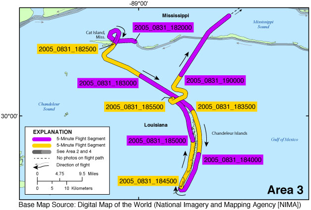
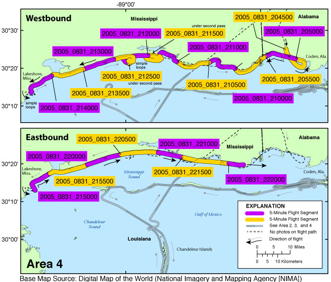
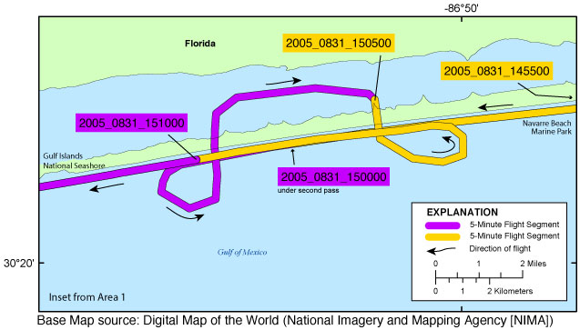
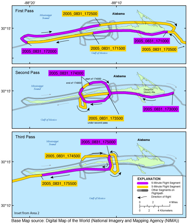
Survey map creation: The survey maps provided in this archive were created with Environmental Systems Research Institute (ESRI) ArcGIS 10.1 software and saved as Adobe Illustrator (.ai) files. Survey maps were edited using Adobe Illustrator CS6 and exported in JPEG format.
Process_Date: 20160624
Process_Contact:
Contact_Information:
Contact_Person_Primary:
Contact_Person: K. Morgan
Contact_Organization: USGS
Contact_Position: Geologist
Contact_Address:
Address_Type: Physical and Mailing
Address: 600 4th Street South
City: St. Petersburg
State_or_Province: FL
Postal_Code: 33701
Country: USA
Contact_Voice_Telephone: (727) 502-8037
Contact_Electronic_Mail_Address: kmorgan@usgs.gov
Process_Step:
Process_Description:
Google Earth file creation: The KML files were created using the photographic navigation file ds1033_05CCH02.csv. The storm track (in KML format) was provided by Unisys Weather. The USGS is the originator of all other layers. To aid navigation through the Keyhole Markup Language (KML) file, each image was assigned a sequential KML number. Table 1 of this report shows the KML number given to each image, the corresponding image name, and associated attributes. Each point on the Google Earth file contains the KML number, storm name, latitude, longitude, image name, geographic area, date, time, a thumbnail of the full-size photograph, and links to the full-size photographs and contact sheets.
Process_Date: 20160624
Process_Contact:
Contact_Information:
Contact_Person_Primary:
Contact_Person: K. Morgan
Contact_Organization: USGS
Contact_Position: Geologist
Contact_Address:
Address_Type: Physical and Mailing
Address: 600 4th Street South
City: St. Petersburg
State_or_Province: FL
Postal_Code: 33701
Country: USA
Contact_Voice_Telephone: (727) 502-8037
Contact_Electronic_Mail_Address: kmorgan@usgs.gov
Process_Step:
Process_Description:
EXIF headers: Exchangeable Image File (EXIF) and International Press Telecommunications Council (IPTC) headers were populated from the command prompt using ExifTool (http://www.sno.phy.queensu.ca/~phil/exiftool, 2012) ExifTool was executed from a directory containing all photographs to be edited and a CSV file with information for each of the photographs. The metadata values for photo creation including time, GPS latitude, GPS longitude, keywords, credit, artist (photographer), caption, copyright, and contact were added to each photograph's EXIF header using a Perl script called met_add.pl.
Process_Date: 20130515
Process_Contact:
Contact_Information:
Contact_Person_Primary:
Contact_Person: K. Morgan
Contact_Organization: USGS
Contact_Position: Geologist
Contact_Address:
Address_Type: Physical and Mailing
Address: 600 4th Street South
City: St. Petersburg
State_or_Province: FL
Postal_Code: 33701
Country: USA
Contact_Voice_Telephone: (727) 502-8037
Contact_Electronic_Mail_Address: kmorgan@usgs.gov
Process_Step:
Process_Description:
FACS Logs: In addition to the process steps described above, the following steps were taken to produce this Data Series Report: digital Field Activity Collection System (FACS) logs were created at the beginning of each flight and saved as PDF and TXT files. In addition, an HTML-based format was used to present the various parts of this archive.
Process_Date: 20160624
Process_Contact:
Contact_Information:
Contact_Person_Primary:
Contact_Person: K. Morgan
Contact_Organization: USGS
Contact_Position: Geologist
Contact_Address:
Address_Type: Physical and Mailing
Address: 600 4th Street South
City: St. Petersburg
State_or_Province: FL
Postal_Code: 33701
Country: USA
Contact_Voice_Telephone: (727) 502-8037
Contact_Electronic_Mail_Address: kmorgan@usgs.gov
Process_Step:
Process_Description:
Added keywords section with USGS persistent identifier as theme keyword.
Process_Date: 20201013
Process_Contact:
Contact_Information:
Contact_Organization_Primary:
Contact_Organization: U.S. Geological Survey
Contact_Person: VeeAnn A. Cross
Contact_Position: Marine Geologist
Contact_Address:
Address_Type: Mailing and Physical
Address: 384 Woods Hole Road
City: Woods Hole
State_or_Province: MA
Postal_Code: 02543-1598
Contact_Voice_Telephone: 508-548-8700 x2251
Contact_Facsimile_Telephone: 508-457-2310
Contact_Electronic_Mail_Address: vatnipp@usgs.gov
Spatial_Data_Organization_Information:
Indirect_Spatial_Reference: none
Spatial_Reference_Information:
Horizontal_Coordinate_System_Definition:
Geographic:
Latitude_Resolution: 0.000001
Longitude_Resolution: 0.000001
Geographic_Coordinate_Units: Decimal degrees
Geodetic_Model:
Horizontal_Datum_Name: North American 1983
Ellipsoid_Name: Geodetic Reference System 80
Semi-major_Axis: 6378137.000000
Denominator_of_Flattening_Ratio: 298.257222
Entity_and_Attribute_Information:
Overview_Description:
Entity_and_Attribute_Overview:
KML file: The Google Earth project is available as a Keyhole Markup Language (KML) file. The Post-Hurricane Katrina storm track KML was provided by Unisys Weather (http://weather.unisys.com/hurricane/index.php). The KML includes photo numbers, photo locations, and the storm track. Entity_and_Attribute_Overview: Unisys Weather, Hurricane Post-Hurricane Katrina storm track, available at http://weather.unisys.com/hurricane/index.php.
Entity_and_Attribute_Overview:
Graphic Image Files: All maps are JPEG images. The index map (fig. 1, http://pubs.usgs.gov/ds/1033/index.html#figure1) shows the Post-Hurricane Katrina coastal oblique aerial photographs collected from Panama City, Florida, to Lakeshore, Mississippi, and the Chandeleur Islands, Louisiana, on August 31, 2005. The index map also shows four areas, which link to more detailed maps and indicate how the full-size photographs are divided into each area.
Entity_and_Attribute_Overview:
Navigation files: The navigation files are ds1033_05CCH02.csv and ds1033_05CCH02_0831_plgrgov.txt (located in the nav folder). The processed files (*.csv) and the raw navigation files (*.txt) are comma-delimited and tab-delimited ASCII text files, respectively.
Entity_and_Attribute_Overview: KML file: The KML file is ds1033_05CCH02.kml.
Entity_and_Attribute_Detail_Citation: none
Distribution_Information:
Distributor:
Contact_Information:
Contact_Person_Primary:
Contact_Person: K. Morgan
Contact_Organization: USGS
Contact_Position: Geologist
Contact_Address:
Address_Type: Physical and Mailing
Address: 600 4th Street South
City: St. Petersburg
State_or_Province: FL
Postal_Code: 33701
Country: USA
Contact_Voice_Telephone: (727) 502-8037
Contact_Electronic_Mail_Address: kmorgan@usgs.gov
Resource_Description: U.S. Geological Survey Data Series 1033
Distribution_Liability:
This publication was prepared by an agency of the United States Government. Although these data were processed successfully on a computer system at the U.S. Geological Survey, no warranty expressed or implied is made regarding the display or utility of the data on any other system, nor shall the act of distribution imply any such warranty. The U.S. Geological Survey shall not be held liable for improper or incorrect use of the data described and (or) contained herein. Reference herein to any specific commercial product, process, or service by trade name, trademark, manufacturer, or otherwise does not constitute or imply its endorsement, recommendation, or favoring by the United States Government or any agency thereof.
Standard_Order_Process:
Digital_Form:
Digital_Transfer_Information:
Format_Name: CSV, JPEG, TXT, KML
Format_Information_Content:
CSV: Comma separate values files representing table information collected during the flight. JPEG: Images can be opened directly with any JPEG-compatible image viewer. The survey's full-size photographs are divided into four areas. ds1033_05CCH02.kml has 3738 photographs. TXT: Text files representing the navigation files, FACS log, metadata and read-me files collected during and after the survey. KML: The KML provided may be viewed with Google Earth (http://www.google.com/earth/download/ge/agree.html).
Digital_Transfer_Option:
Online_Option:
Computer_Contact_Information:
Network_Address:
Network_Resource_Name: https://doi.org/10.3133/ds1033
Access_Instructions: Available Online
Fees: Prices vary. None.
Ordering_Instructions: Available online.
Metadata_Reference_Information:
Metadata_Date: 20201013
Metadata_Contact:
Contact_Information:
Contact_Person_Primary:
Contact_Person: K. Morgan
Contact_Organization: USGS
Contact_Position: Geologist
Contact_Address:
Address_Type: Physical and Mailing
Address: 600 4th Street South
City: St. Petersburg
State_or_Province: FL
Postal_Code: 33701
Country: USA
Contact_Voice_Telephone: (727) 502-8037
Contact_Electronic_Mail_Address: kmorgan@usgs.gov
Metadata_Standard_Name:
Federal Geographic Data Committee Content (FGDC) Standards for Digital Geospatial Metadata
Metadata_Standard_Version: FGDC-STD-001-1998

This page is <https://cmgds.marine.usgs.gov/catalog/spcmsc/ds1033_metadata.html>
Generated by mp version 2.9.50 on Tue Sep 21 18:18:54 2021