Baseline coastal oblique aerial photographs collected from Navarre Beach, Florida, to Breton Island, Louisiana, September 1, 2014

Metadata also available as - [Questions & Answers] - [Parseable text] - [XML]

Metadata:

Identification_Information:
Citation:
Citation_Information:
Originator: Karen L.M. Morgan
Publication_Date: 2015
Title:
Baseline coastal oblique aerial photographs collected from Navarre Beach, Florida, to Breton Island, Louisiana, September 1, 2014
Geospatial_Data_Presentation_Form: Multimedia presentation
Series_Information:
Series_Name: U.S. Geological Survey Data Series
Issue_Identification: Data Series 952
Publication_Information:
Publication_Place: St. Petersburg, Fla.
Publisher: U.S. Geological Survey
Online_Linkage: http://pubs.usgs.gov/ds/0952 (in press)
Description:
Abstract:
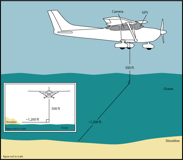
The U.S. Geological Survey (USGS) conducts baseline and storm response photography missions to document and understand the changes in vulnerability of the Nation's coasts to extreme storms. On September 1, 2014, the USGS conducted an oblique aerial photographic survey from Navarre Beach, Florida, to Breton Island, Louisiana, aboard a Maule MT57 aircraft at an altitude of 500 feet (ft) and approximately 1,200 ft offshore (Figure 2, http://pubs.usgs.gov/ds/0952/html/ds952_fig2.html). This survey was flown to collect data for assessing incremental changes since the last survey, flown July 2013, and can be used for assessing future coastal change. The photographs provided here are Joint Photographic Experts Group (JPEG) images. The photograph locations are an estimate of the position of the and aircraft do not indicate the location of the feature in the images (see the Navigation Data page for additional details, http://pubs.usgs.gov/ds/0952/html/ds952_nav.html). These photographs document the configuration of the barrier islands and other coastal features at the time of the survey. CSV: Comma separate values files representing table information collected during the flight. JPEG: Images can be opened directly with any JPEG-compatible image viewer. The survey's full-size photographs are divided into ?two ?areas. KML: ds952_2014-?326-FA.kml has? 1,111 photographs. TXT: Text files representing the navigation files, FACS log, metadata and readme files collected during and after the survey. KML: The KMLs provided may be viewed with Google Earth (http://www.google.com/earth/download/ge/agree.html). ExifTool (http://www.sno.phy.queensu.ca/~phil/exiftool/) is a free software program for reading, writing, and manipulating image, audio, and video metadata. ExifTool was used to add the following to the header of each photo: time of collection, Global Positioning System (GPS) latitude, GPS longitude, keywords, credit, artist (photographer), caption, copyright, and contact information. Photographs can be opened directly with any JPEG-compatible image viewer by clicking on a thumbnail on the contact sheet. All image times are recorded in Coordinated Universal Time (UTC). Table 1 (http://pubs.usgs.gov/ds/0952/html/ds952_table.html) provides detailed information about the assigned location, name, date, and time the photograph was taken along with links to the photograph. In addition to the photographs, a Google Earth Keyhole Markup Language (KML) file is provided and can be used to view the images by clicking on the marker and then clicking on either the thumbnail or the link above the thumbnail. The KML files were created using the photographic navigation files. Note: A KML number was assigned to each photograph to aid navigation of the Google Earth file. These numbers correspond to the site labels in Google Earth.
Purpose:
To provide access to digital photographs taken as part of the September 1, 2014, baseline oblique aerial survey collected along the coast, from Navarre Beach, Florida, to Breton Island, Louisiana, and to provide access to attribute data that document the time and location of where each photograph was taken.
Supplemental_Information:
For a summary of field activity 2014-326-FA please see https://cmgds.marine.usgs.gov/fan_info.php?fan=2771. Ancillary files included in this release are ds952_2014-326-FA.csv, ds952_2014-326-FA_0901_garmin196.txt, and ds952_2014-326-FA.kml, in addition to the digitized oblique aerial image files.
Time_Period_of_Content:
Time_Period_Information:
Range_of_Dates/Times:
Beginning_Date: 20140901
Ending_Date: 20140901
Currentness_Reference: ground condition
Status:
Progress: Complete
Maintenance_and_Update_Frequency: as needed
Spatial_Domain:
Bounding_Coordinates:
West_Bounding_Coordinate: -89.190333
East_Bounding_Coordinate: -86.862800
North_Bounding_Coordinate: 30.434033
South_Bounding_Coordinate: 29.467783
Keywords:
Theme:
Theme_Keyword_Thesaurus: USGS Metadata Identifier
Theme_Keyword: USGS:63a01fe3-d001-4307-938f-d8571065f0ca
Theme:
Theme_Keyword_Thesaurus: General
Theme_Keyword: U.S. Geological Survey
Theme_Keyword: National Assessment Project
Theme_Keyword: photographs
Theme_Keyword: coastline
Theme_Keyword: barrier islands
Theme_Keyword: Barrier Island Evolution Research
Theme_Keyword: Coastal Aerial Photography
Theme:
Theme_Keyword_Thesaurus: ISO 19115 Topic Category
Theme_Keyword: environment
Theme_Keyword: imageryBaseMapsEarthCover
Theme_Keyword: structure
Place:
Place_Keyword_Thesaurus: Geographic Names Information Service (GNIS)
Place_Keyword: Navarre Beach
Place_Keyword: Florida
Place_Keyword: Alabama
Place_Keyword: Mississippi
Place_Keyword: Louisiana
Place_Keyword: Chandeleur Islands
Place_Keyword: Breton Island
Place_Keyword: Grand Gosier Island
Place_Keyword: Curlew Island
Place_Keyword: Dauphin Island
Place_Keyword: Petit Bois Island
Place_Keyword: Horn Island
Place_Keyword: Ship Island
Place_Keyword: Cat Island
Temporal:
Temporal_Keyword_Thesaurus: General
Temporal_Keyword: 2014
Access_Constraints: None
Use_Constraints:
The U.S. Geological Survey requests to be acknowledged as originator of the data in future products or derivative research.
Point_of_Contact:
Contact_Information:
Contact_Person_Primary:
Contact_Person: K. Morgan
Contact_Organization: USGS
Contact_Position: Geologist
Contact_Address:
Address_Type: Physical and Mailing
Address: 600 4th Street South
City: St. Petersburg
State_or_Province: FL
Postal_Code: 33701
Country: USA
Contact_Voice_Telephone: (727) 502-8037
Contact_Electronic_Mail_Address: kmorgan@usgs.gov
Browse_Graphic:
Browse_Graphic_File_Name: http://pubs.usgs.gov/ds/0952/maps/index.jpg
Browse_Graphic_File_Description:
Index map of all survey areas covered during USGS field activity 2014-326-FA.
Browse_Graphic_File_Type: JPEG
Browse_Graphic:
Browse_Graphic_File_Name: http://pubs.usgs.gov/ds/0952/html/images/fig2.jpg
Browse_Graphic_File_Description:
Graphic for Acquisition Geometry (Figure 2) for USGS field activity 2014-326-FA. Graphic shows basic flight distance from the shore and elevation during the survey for the aircraft used.
Browse_Graphic_File_Type: JPEG
Browse_Graphic:
Browse_Graphic_File_Name: http://pubs.usgs.gov/ds/0952/html/images/contents.jpg
Browse_Graphic_File_Description:
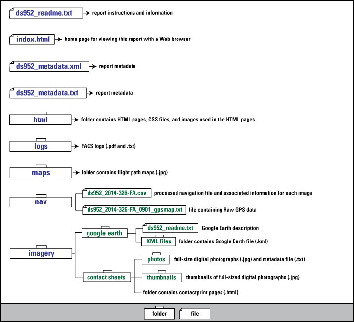
Graphic used on Contents page of USGS field activity 2014-326-FA oblique aerial photographs Data Series. Graphic shows the directory structure of the publication.
Browse_Graphic_File_Type: JPEG
Browse_Graphic:
Browse_Graphic_File_Name: http://pubs.usgs.gov/ds/0952/maps/2014-326-FA_1.jpg
Browse_Graphic_File_Description:
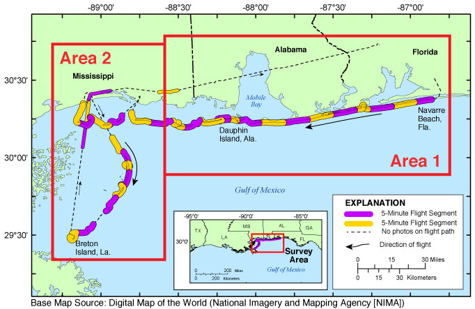
Map showing the extent of Area 1 for the baseline coastal oblique aerial photographs from Navarre Beach, Florida, to Petit Bois Island, Mississippi. The flight path, divided into 5-minute segments, is represented by the alternating purple and yellow lines. Pages containing thumbnail images of photographs, referred to as contact sheets, were created based on these segments.
Browse_Graphic_File_Type: JPEG
Browse_Graphic:
Browse_Graphic_File_Name: http://pubs.usgs.gov/ds/0952/maps/2014-326-FA_2.jpg
Browse_Graphic_File_Description:
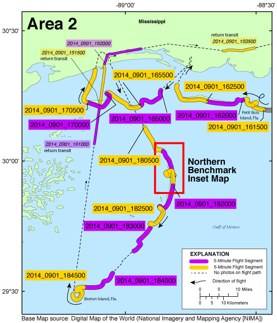
Map showing the extent of Area 2 for the baseline coastal oblique aerial photographs from Petit Bois Island, Mississippi, to Breton Island, Louisiana. The flight path, divided into 5-minute segments, is represented by the alternating purple and yellow lines. Pages containing thumbnail images of photographs, referred to as contact sheets, were created based on these segments.
Browse_Graphic_File_Type: JPEG
Browse_Graphic:
Browse_Graphic_File_Name: http://pubs.usgs.gov/ds/0952/maps/inset4_dauphin.jpg
Browse_Graphic_File_Description:
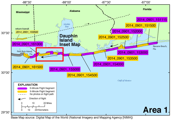
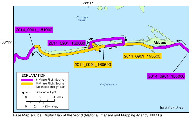
Inset map showing the extent of the Dauphin Island inset map for the baseline coastal oblique aerial photographs of Dauphin Island, Alabama. The flight path, divided up into 5-minute segments, is represented by the alternating purple and yellow lines. Pages containing thumbnail images of photographs, referred to as contact sheets, were created based on these segments.
Browse_Graphic_File_Type: JPEG
Browse_Graphic:
Browse_Graphic_File_Name: http://pubs.usgs.gov/ds/0952/maps/inset5_northbenchmark.jpg
Browse_Graphic_File_Description:
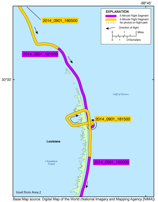
Inset map showing the extent of the Northern Benchmark inset map for the baseline coastal oblique aerial photographs taken in the area of the Northern Benchmark of the Chandeleur Islands. The flight path, divided up into 5-minute segments, is represented by the alternating purple and yellow lines. Pages containing thumbnail images of photographs, referred to as contact sheets, were created based on these segments.
Browse_Graphic_File_Type: JPEG
Data_Set_Credit:
Funding and (or) support for this study was provided by the USGS Coastal and Marine Geology Program (CMGP). The author wishes to thank pilot, Ian McIntyre, and photographer, Amy Hartsfield of Amy & Company, Inc., for their assistance in data collection.
Data_Quality_Information:
Attribute_Accuracy:
Attribute_Accuracy_Report:
Best attempts were made to set the camera to UTC time on the GPS receivers at the beginning of each flight. Latitude, longitude, and time were collected at an interval of approximately once every 5 seconds. NOTE: Latitude and longitude positions in this report refer to the position of the aircraft, not the position of the landmarks photographed. Refer to the Process Steps below for more detail.
Completeness_Report: No known issues
Positional_Accuracy:
Horizontal_Positional_Accuracy:
Horizontal_Positional_Accuracy_Report:
Best attempts were made to maintain the same relative distance between the aircraft and the beach in order to keep a constant field of view.
Quantitative_Horizontal_Positional_Accuracy_Assessment:
Horizontal_Positional_Accuracy_Value: 2 meters
Horizontal_Positional_Accuracy_Explanation:
Based on manufacturer specifications where available. The GPS receiver used to provide navigation is accurate to within 2 meters.
Logical_Consistency_Report:
Data presented here include the digitally collected photographs in JPEG format with EXIF headers embedded with the individual photograph's location along the flight path of a baseline coastal oblique aerial photographic survey of the coast, from Navarre Beach, Florida, to Breton Island, Louisiana. This mission was flown on September 1, 2014, aboard a Maule MT57, tail number N5500K. Crew members, contracted by the USGS in St. Petersburg, Fla., include Amy Hartsfield (photography contractor) and pilot, Ian McIntyre, of Amy & Company, Inc. Still photography was collected along the coast during this survey. GPS Data Collection - Instrument: Garmin GPSMAP 196. Data Collection Interval: 1 second. Data File Format: Text. Number of files created: 1. Computer/Software: none. Computer: none The GPS unit was used to record navigation fixes of the aircraft, not the position of the features imaged. No photographs were taken during the following 5-minute segment due to transiting between locations: ds952_2014_0901_183500.html. For a summary of field activity 2014-326-FA please see https://cmgds.marine.usgs.gov/fan_info.php?fan=2014-326-FA.
Lineage:
Process_Step:
Process_Description:
Photographs were taken using a Canon EOS 5D Mark III. Images were written to internal camera cards. Image size is approximately 22 megapixels.
Process_Date: 20140910
Process_Contact:
Contact_Information:
Contact_Person_Primary:
Contact_Person: K. Morgan
Contact_Organization: USGS
Contact_Position: Geologist
Contact_Address:
Address_Type: Physical and Mailing
Address: 600 4th Street South
City: St. Petersburg
State_or_Province: FL
Postal_Code: 33701
Country: USA
Contact_Voice_Telephone: (727) 502-8037
Contact_Electronic_Mail_Address: kmorgan@usgs.gov
Process_Step:
Process_Description:
Navigation files were extracted as comma-delimited American Standard Code for Information Interchange (ASCII) text files from the Garmin GPSMAP 196. The GPS recorded latitude, longitude, date and time.
Process_Date: 20140910
Process_Contact:
Contact_Information:
Contact_Person_Primary:
Contact_Person: K. Morgan
Contact_Organization: USGS
Contact_Position: Geologist
Contact_Address:
Address_Type: Physical and Mailing
Address: 600 4th Street South
City: St. Petersburg
State_or_Province: FL
Postal_Code: 33701
Country: USA
Contact_Voice_Telephone: (727) 502-8037
Contact_Electronic_Mail_Address: kmorgan@usgs.gov
Process_Step:
Process_Description:
Images were saved to internal camera cards. Image size is approximately 22 megapixels. Images in JPG format were saved using the filename format yyyy_mmdd_hhmmssd.jpg (where the "d" signifies digital acquisition using a Canon EOS 5D Mark III). The names provide information about the photograph's year, month, day, hour, minute, and second. For example, image 2014_0901_133636d.jpg was taken September 1, 2014, at 13:36:36 UTC. Best effort was made to set the Canon EOS 5D Mark III's internal clock to within 1 second of UTC at the beginning of the flight.
Process_Date: 20140910
Process_Contact:
Contact_Information:
Contact_Person_Primary:
Contact_Person: K. Morgan
Contact_Organization: USGS
Contact_Position: Geologist
Contact_Address:
Address_Type: Physical and Mailing
Address: 600 4th Street South
City: St. Petersburg
State_or_Province: FL
Postal_Code: 33701
Country: USA
Contact_Voice_Telephone: (727) 502-8037
Contact_Electronic_Mail_Address: kmorgan@usgs.gov
Process_Step:
Process_Description:
Navigation processing: Using a custom Perl script written by K. Morgan, USGS, GPS data and image files were used to generate a comma-separated value (CSV) file containing latitude, longitude, and time records for each image. This processed navigation file was saved as a CSV file, ds952_2014-326-FA.csv, using Microsoft Excel 2011.
Process_Date: 20140910
Process_Contact:
Contact_Information:
Contact_Person_Primary:
Contact_Person: K. Morgan
Contact_Organization: USGS
Contact_Position: Geologist
Contact_Address:
Address_Type: Physical and Mailing
Address: 600 4th Street South
City: St. Petersburg
State_or_Province: FL
Postal_Code: 33701
Country: USA
Contact_Voice_Telephone: (727) 502-8037
Contact_Electronic_Mail_Address: kmorgan@usgs.gov
Process_Step:
Process_Description:
The digital images were organized into 5-minute (time) segments. These 5-minute segments were used to create HTML pages, called contact sheets. A contact sheet was created for every 5-minute segment of the survey. The contact sheets contain thumbnails of each of the photographs. Each thumbnail links to the corresponding full-size area map or photograph.
Process_Date: 20140910
Process_Contact:
Contact_Information:
Contact_Person_Primary:
Contact_Person: K. Morgan
Contact_Organization: USGS
Contact_Position: Geologist
Contact_Address:
Address_Type: Physical and Mailing
Address: 600 4th Street South
City: St. Petersburg
State_or_Province: FL
Postal_Code: 33701
Country: USA
Contact_Voice_Telephone: (727) 502-8037
Contact_Electronic_Mail_Address: kmorgan@usgs.gov
Process_Step:
Process_Description:
Geospatial Processing: The processed navigation file was edited using Microsoft Excel 2011 and saved as comma-separated value (CSV) files to make them compatible with ArcGIS software. The latitude/longitude data from the CSV navigation file were used to produce an Environmental Systems Research Institute (Esri) shapefiles using ArcGIS 10.1. These shapefile were used to produce the JPEG maps included in this report. These shapefiles are not included in this report.
Process_Date: 20140910
Process_Contact:
Contact_Information:
Contact_Person_Primary:
Contact_Person: K. Morgan
Contact_Organization: USGS
Contact_Position: Geologist
Contact_Address:
Address_Type: Physical and Mailing
Address: 600 4th Street South
City: St. Petersburg
State_or_Province: FL
Postal_Code: 33701
Country: USA
Contact_Voice_Telephone: (727) 502-8037
Contact_Electronic_Mail_Address: kmorgan@usgs.gov
Process_Step:
Process_Description:
Survey map creation: The survey maps provided in this archive were created with Esri ArcGIS 10.1 software and saved as Adobe Illustrator (*.ai) files. Survey maps were edited using Adobe Illustrator CS6 and exported in JPEG format.
Process_Date: 20141015
Process_Contact:
Contact_Information:
Contact_Person_Primary:
Contact_Person: K. Morgan
Contact_Organization: USGS
Contact_Position: Geologist
Contact_Address:
Address_Type: Physical and Mailing
Address: 600 4th Street South
City: St. Petersburg
State_or_Province: FL
Postal_Code: 33701
Country: USA
Contact_Voice_Telephone: (727) 502-8037
Contact_Electronic_Mail_Address: kmorgan@usgs.gov
Process_Step:
Process_Description:
Google Earth file creation: The KML files were created using the photographic navigation file ds952_2014-326-FA.csv. To aid navigation through the KML file, each image was assigned a sequential KML number. Table 1 (http://pubs.usgs.gov/ds/0952/html/ds952_table.html) of this report shows the KML number given to each image, the corresponding image name, and associated attributes. Each point on the Google Earth file contains the KML number, storm name, latitude, longitude, image name, geographic area, date, time, a thumbnail of the full-size photograph, and links to the full-size photographs and contact sheets.
Process_Date: 20141015
Process_Contact:
Contact_Information:
Contact_Person_Primary:
Contact_Person: K. Morgan
Contact_Organization: USGS
Contact_Position: Geologist
Contact_Address:
Address_Type: Physical and Mailing
Address: 600 4th Street South
City: St. Petersburg
State_or_Province: FL
Postal_Code: 33701
Country: USA
Contact_Voice_Telephone: (727) 502-8037
Contact_Electronic_Mail_Address: kmorgan@usgs.gov
Process_Step:
Process_Description:
EXIF headers: Exchangeable Image File (EXIF) and International Press Telecommunications Council (IPTC) headers were populated from the command prompt using ExifTool (http://www.sno.phy.queensu.ca/~phil/exiftool, 2012) as part of the post-flight processing using a Perl script written by Karen Morgan, USGS - St. Petersburg, Fla. ExifTool added the following data to the EXIFHeader: time of collection, GPS latitude, GPS longitude, keywords, credit, artist (photographer), caption, copyright, and contact information.
Process_Date: 20140910
Process_Contact:
Contact_Information:
Contact_Person_Primary:
Contact_Person: K. Morgan
Contact_Organization: USGS
Contact_Position: Geologist
Contact_Address:
Address_Type: Physical and Mailing
Address: 600 4th Street South
City: St. Petersburg
State_or_Province: FL
Postal_Code: 33701
Country: USA
Contact_Voice_Telephone: (727) 502-8037
Contact_Electronic_Mail_Address: kmorgan@usgs.gov
Process_Step:
Process_Description:
In addition to the process steps described above, the following steps were taken to produce this Data Series: Digital Field Activity Collection System (FACS) logs were created at the beginning of each flight and saved as PDF and TXT files. In addition, an HTML-based format was used to present the various parts of this archive.
Process_Date: 20141015
Process_Contact:
Contact_Information:
Contact_Person_Primary:
Contact_Person: K. Morgan
Contact_Organization: USGS
Contact_Position: Geologist
Contact_Address:
Address_Type: Physical and Mailing
Address: 600 4th Street South
City: St. Petersburg
State_or_Province: FL
Postal_Code: 33701
Country: USA
Contact_Voice_Telephone: (727) 502-8037
Contact_Electronic_Mail_Address: kmorgan@usgs.gov
Process_Step:
Process_Description:
Added keywords section with USGS persistent identifier as theme keyword.
Process_Date: 20201013
Process_Contact:
Contact_Information:
Contact_Organization_Primary:
Contact_Organization: U.S. Geological Survey
Contact_Person: VeeAnn A. Cross
Contact_Position: Marine Geologist
Contact_Address:
Address_Type: Mailing and Physical
Address: 384 Woods Hole Road
City: Woods Hole
State_or_Province: MA
Postal_Code: 02543-1598
Contact_Voice_Telephone: 508-548-8700 x2251
Contact_Facsimile_Telephone: 508-457-2310
Contact_Electronic_Mail_Address: vatnipp@usgs.gov
Spatial_Data_Organization_Information:
Indirect_Spatial_Reference: none
Spatial_Reference_Information:
Horizontal_Coordinate_System_Definition:
Geographic:
Latitude_Resolution: 0.000001
Longitude_Resolution: 0.000001
Geographic_Coordinate_Units: Decimal degrees
Geodetic_Model:
Horizontal_Datum_Name: D North American 1983
Ellipsoid_Name: Geodetic Reference System 80
Semi-major_Axis: 6378137.000000
Denominator_of_Flattening_Ratio: 298.257222
Entity_and_Attribute_Information:
Overview_Description:
Entity_and_Attribute_Overview:
Graphic Image Files: The index map is a JPEG image. The index map shows the baseline coastal oblique aerial photographs collected from Navarre Beach, Florida, to Breton Island, Louisiana, September 1, 2014. The index map also shows the delineation of two area boxes, which link to more detailed maps and indicate how the full-size photographs have been divided into area(s) The survey area maps are JPEG images. The survey maps contain links to the 5-minute segment contact sheet pages.
Entity_and_Attribute_Overview:
Navigation file(s): The processed files are ds952_2014-326-FA.csv (comma delimited) and ds952_2014-326-FA_0901_garmin196.txt (tab delimited) are located in the nav folder, http://pubs.usgs.gov/ds/0952/nav).
Entity_and_Attribute_Overview:
KML file(s): The KML files are ds952_2014-326-FA.kml and ds952_2014-326-FA_local.kml.
Entity_and_Attribute_Detail_Citation:
Subino, J.A., Morgan, K.L.M., Krohn, M.D., Miller, G.K., Dadisman, S.V., and Forde, A.S., 2012, Archive of post-Hurricane Charley coastal oblique aerial photographs collected during U.S. Geological Survey field activity 04CCH01 from Marco Island to Fort DeSoto, Florida, August 15, 2004: U.S. Geological Survey Data Series 651, 2 DVDs, at http://pubs.usgs.gov/ds/651/.
Distribution_Information:
Distributor:
Contact_Information:
Contact_Person_Primary:
Contact_Person: K. Morgan
Contact_Organization: USGS
Contact_Position: Geologist
Contact_Address:
Address_Type: Physical and Mailing
Address: 600 4th Street South
City: St. Petersburg
State_or_Province: FL
Postal_Code: 33701
Country: USA
Contact_Voice_Telephone: (727) 502-8037
Contact_Electronic_Mail_Address: kmorgan@usgs.gov
Resource_Description: U.S. Geological Survey Data Series 952
Distribution_Liability:
This publication was prepared by an agency of the United States Government. Although these data have been processed successfully on a computer system at the U.S. Geological Survey, no warranty expressed or implied is made regarding the display or utility of the data on any other system, nor shall the act of distribution imply any such warranty. The U.S. Geological Survey shall not be held liable for improper or incorrect use of the data described and (or) contained herein. Reference herein to any specific commercial product, process, or service by trade name, trademark, manufacturer, or otherwise does not constitute or imply its endorsement, recommendation, or favoring by the United States Government or any agency thereof.
Standard_Order_Process:
Digital_Form:
Digital_Transfer_Information:
Format_Name: CSV, JPEG, TXT, KML
Format_Information_Content:
CSV: Comma-separated value files representing table information collected during the flight. JPEG: Images can be opened directly with any JPEG-compatible image viewer. The survey's full-size photographs are divided into areas. ucfan.kml has 1,111 photographs. TXT: Text files representing the navigation files, FACS log, metadata and readme files collected during and after the survey. KML: The KMLs provided may be viewed with Google Earth (http://www.google.com/earth/download/ge/agree.html).
Digital_Transfer_Option:
Online_Option:
Computer_Contact_Information:
Network_Address:
Network_Resource_Name: http://pubs.usgs.gov/ds/0952
Access_Instructions: Available Online
Fees: Prices vary. None.
Ordering_Instructions:
Publications are available from USGS Information Services, Box 25286, Federal Center, Denver, Col., 80225-0046 (telephone: 1-888-ASK-USGS, e-mail: infoservices@usgs.gov).
Metadata_Reference_Information:
Metadata_Date: 20210224
Metadata_Contact:
Contact_Information:
Contact_Person_Primary:
Contact_Person: K. Morgan
Contact_Organization: USGS
Contact_Position: Geologist
Contact_Address:
Address_Type: Physical and Mailing
Address: 600 4th Street South
City: St. Petersburg
State_or_Province: FL
Postal_Code: 33701
Country: USA
Contact_Voice_Telephone: (727) 502-8037
Contact_Electronic_Mail_Address: kmorgan@usgs.gov
Metadata_Standard_Name: FGDC Content Standards for Digital Geospatial Metadata
Metadata_Standard_Version: FGDC-STD-001-1998

This page is <https://cmgds.marine.usgs.gov/catalog/spcmsc/ds952_metadata.html>
Generated by mp version 2.9.50 on Tue Sep 21 18:18:54 2021