Citation:
Citation_Information:
Originator: Karen L.M. Morgan
Publication_Date: 2015
Title:
Baseline coastal oblique aerial photographs collected from Key Largo, Florida, to the Florida/Georgia border, September 5-6, 2014
Geospatial_Data_Presentation_Form: Multimedia presentation
Series_Information:
Series_Name: U.S. Geological Survey Data Series
Issue_Identification: Data Series 953
Publication_Information:
Publication_Place: St. Petersburg, Fla.
Publisher: U.S. Geological Survey
Online_Linkage: http://pubs.usgs.gov/ds/0953
Description:
Abstract:
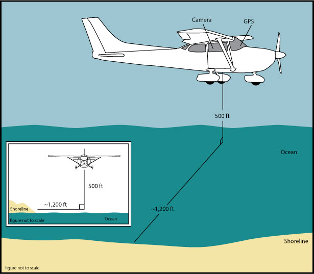
The U.S. Geological Survey (USGS) conducts baseline and storm response photography missions to document and understand the changes in vulnerability of the Nation's coasts to extreme storms. On September 5-6, 2014, the USGS conducted an oblique aerial photographic survey from Key Largo, Florida, to the Florida/Georgia border aboard a Cessna 182 aircraft at an altitude of 500 feet (ft) and approximately 1,200 ft offshore (Figure 2,
http://pubs.usgs.gov/ds/0953/html/ds953_fig2.html). This mission was flown to collect data for assessing incremental changes since the last survey, flown October 1998, and can be used for assessing future coastal change. The photographs provided here are Joint Photographic Experts Group (JPEG) images. The photograph locations are an estimate of the position of the aircraft and do not indicate the location of the feature in the images (see the Navigation Data page, for additional details:
http://pubs.usgs.gov/ds/0953/html/ds953_nav.html). These photographs document the configuration of the barrier islands and other coastal features at the time of the survey. ExifTool (
http://www.sno.phy.queensu.ca/~phil/exiftool/) is a free software program for reading, writing, and manipulating image, audio, and video metadata. ExifTool (
http://www.sno.phy.queensu.ca/~phil/exiftool/) is a free software program for reading, writing, and manipulating image, audio, and video metadata. ExifTool was used to add the following to the header of each photo: time of collection, Global Positioning System (GPS) latitude, GPS longitude, keywords, credit, artist (photographer), caption, copyright, and contact information. Photographs can be opened directly with any JPEG-compatible image viewer by clicking on a thumbnail on the contact sheet. All image times are recorded in Coordinated Universal Time (UTC). Table 1 (
http://pubs.usgs.gov/ds/0953/html/ds953_table.html) provides detailed information about the assigned location, name, date, and time the photograph was taken along with links to the photograph. In addition to the photographs, a Google Earth Keyhole Markup Language (KML) file is provided and can be used to view the images by clicking on the marker and then clicking on either the thumbnail or the link above the thumbnail. The KML files were created using the photographic navigation files. Note: A KML number was assigned to each photograph to aid navigation of the Google Earth file. These numbers correspond to the site labels in Google Earth.
To provide access to digital photographs taken as part of the September 5-6, 2014, baseline oblique aerial survey collected along the coast, from Key Largo, Florida, to the Florida/Georgia border, and to provide access to attribute data that document the time and location of where each photograph was taken.
Supplemental_Information:
Time_Period_of_Content:
Time_Period_Information:
Range_of_Dates/Times:
Beginning_Date: 20140905
Ending_Date: 20140906
Currentness_Reference: ground condition
Status:
Progress: Complete
Maintenance_and_Update_Frequency: as needed
Spatial_Domain:
Bounding_Coordinates:
West_Bounding_Coordinate: -81.4513010
East_Bounding_Coordinate: -80.0190130
North_Bounding_Coordinate: 31.0981900
South_Bounding_Coordinate: 24.9641310
Keywords:
Theme:
Theme_Keyword_Thesaurus: USGS Metadata Identifier
Theme_Keyword: USGS:a1bf45db-ac9e-40eb-8878-c4dc26ad5b57
Theme:
Theme_Keyword_Thesaurus: General
Theme_Keyword: U.S. Geological Survey
Theme_Keyword: National Assessment Project
Theme_Keyword: photographs
Theme_Keyword: coastline
Theme_Keyword: beach erosion
Theme_Keyword: Coastal Aerial Photography
Theme_Keyword: Baseline Survey
Theme:
Theme_Keyword_Thesaurus: ISO 19115 Topic Category
Theme_Keyword: environment
Theme_Keyword: imageryBaseMapsEarthCover
Theme_Keyword: structure
Place:
Place_Keyword_Thesaurus: Geographic Names Information Service (GNIS)
Place_Keyword: Florida
Place_Keyword: Key Largo
Place_Keyword: Plantation
Place_Keyword: Miami
Place_Keyword: West Palm Beach
Place_Keyword: Melbourne
Place_Keyword: Kennedy Space Center
Place_Keyword: Daytona Beach
Place_Keyword: Jacksonville
Place_Keyword: Amelia Island
Temporal:
Temporal_Keyword_Thesaurus: General
Temporal_Keyword: 2014
Access_Constraints: None
Use_Constraints:
The U.S. Geological Survey requests to be acknowledged as originator of the data in future products or derivative research.
Point_of_Contact:
Contact_Information:
Contact_Person_Primary:
Contact_Person: K. Morgan
Contact_Organization: USGS
Contact_Position: Geologist
Contact_Address:
Address_Type: Physical and Mailing
Address: 600 4th Street South
City: St. Petersburg
State_or_Province: FL
Postal_Code: 33701
Country: USA
Contact_Voice_Telephone: (727) 502-8037
Contact_Electronic_Mail_Address: [email protected]
Browse_Graphic:
Browse_Graphic_File_Name: http://pubs.usgs.gov/ds/0953/maps/index.jpg
Browse_Graphic_File_Description:
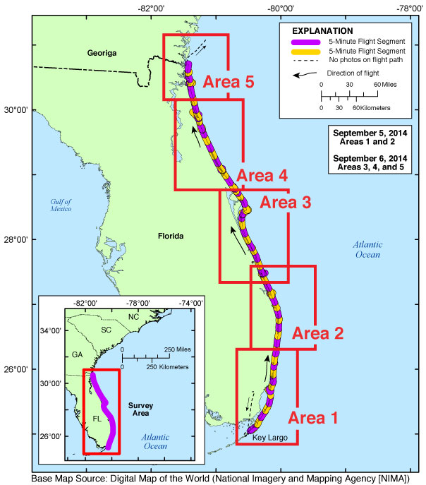
Map showing the baseline coastal oblique survey flight path from Key Largo, Florida, to the Florida/Georgia border, September 5-6, 2014..
Browse_Graphic_File_Type: JPEG
Browse_Graphic:
Browse_Graphic_File_Name: http://pubs.usgs.gov/ds/0953/html/images/fig2.jpg
Browse_Graphic_File_Description:
Graphic for Acquisition Geometry (Figure 2) for USGS field activity 2014-327-FA. Graphic shows basic flight distance from the shore and elevation during the survey for the aircraft used.
Browse_Graphic_File_Type: JPEG
Browse_Graphic:
Browse_Graphic_File_Name: http://pubs.usgs.gov/ds/0953/html/images/contents.jpg
Browse_Graphic_File_Description:
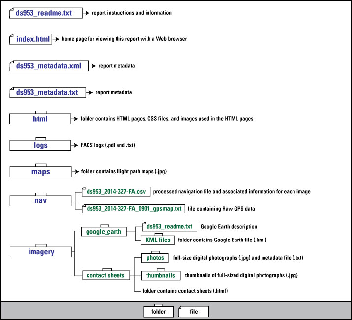
Graphic used on Contents page of USGS field activity 2014-327-FA oblique aerial photographs data series. Graphic shows the directory structure of the publication.
Browse_Graphic_File_Type: JPEG
Browse_Graphic:
Browse_Graphic_File_Name: http://pubs.usgs.gov/ds/0953/maps/2014-327-FA_1.jpg
Browse_Graphic_File_Description:
Area 1 - Key Largo to Hillsboro Beach, Florida. Map showing the baseline coastal oblique aerial survey flight path divided into 5-minute (time) segments. The flight path is represented by the alternating purple and yellow lines. Pages containing thumbnail images of photographs, referred to as contact sheets, were created based on these segments.
Browse_Graphic_File_Type: JPEG
Browse_Graphic:
Browse_Graphic_File_Name: http://pubs.usgs.gov/ds/0953/maps/2014-327-FA_2.jpg
Browse_Graphic_File_Description:
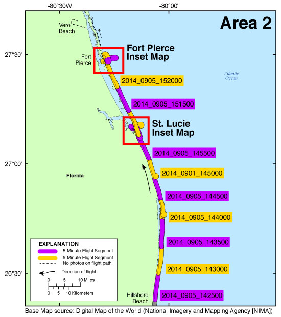
Area 2 - Hillsboro Beach to Fort Pierce, Florida. Map showing the baseline coastal oblique aerial survey flight path divided into 5-minute (time) segments. The flight path is represented by the alternating purple and yellow lines. Pages containing thumbnail images of photographs, referred to as contact sheets, were created based on these segments.
Browse_Graphic_File_Type: JPEG
Browse_Graphic:
Browse_Graphic_File_Name: http://pubs.usgs.gov/ds/0953/maps/2014-327-FA_3.jpg
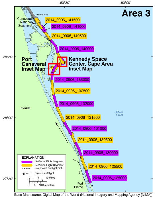
Browse_Graphic_File_Description:
Area 3 - Fort Pierce to the Canaveral National Seashore, Florida. Map showing the baseline coastal oblique aerial survey flight path divided into 5-minute (time) segments. The flight path is represented by the alternating purple and yellow lines. Pages containing thumbnail images of photographs, referred to as contact sheets, were created based on these segments.
Browse_Graphic_File_Type: JPEG
Browse_Graphic:
Browse_Graphic_File_Name: http://pubs.usgs.gov/ds/0953/maps/2014-327-FA_4.jpg
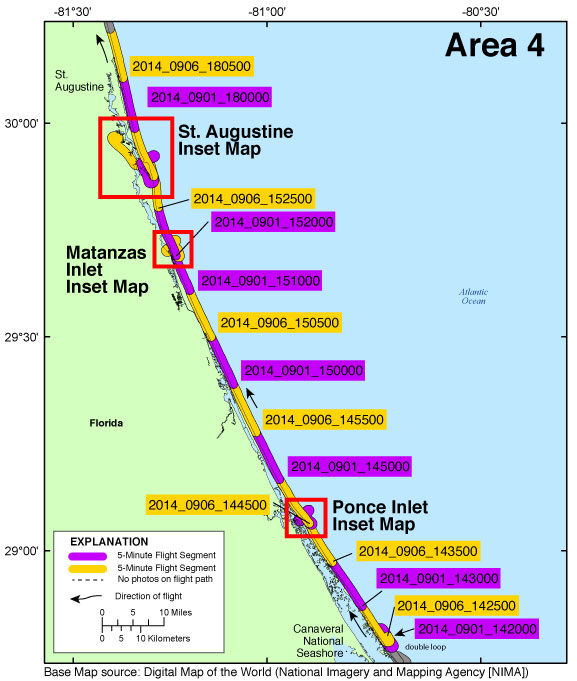
Browse_Graphic_File_Description:
Area 4 - The Canaveral National Seashore to St Augustine, Florida. Map showing the baseline coastal oblique aerial survey flight path divided into 5-minute (time) segments. The flight path is represented by the alternating purple and yellow lines. Pages containing thumbnail images of photographs, referred to as contact sheets, were created based on these segments.
Browse_Graphic_File_Type: JPEG
Browse_Graphic:
Browse_Graphic_File_Name: http://pubs.usgs.gov/ds/0953/maps/2014-327-FA_5.jpg
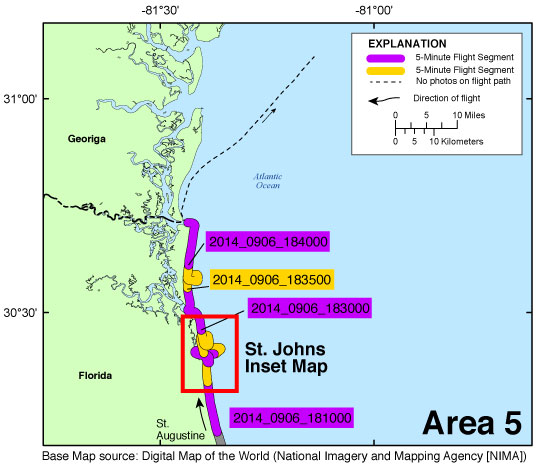
Browse_Graphic_File_Description:
Area 5 - St Augustine to the Florida/Georgia border. Map showing the baseline coastal oblique aerial survey flight path divided into 5-minute (time) segments. The flight path is represented by the alternating purple and yellow lines. Pages containing thumbnail images of photographs, referred to as contact sheets, were created based on these segments.
Browse_Graphic_File_Type: JPEG
Browse_Graphic:
Browse_Graphic_File_Name: http://pubs.usgs.gov/ds/0953/maps/inset04_stlucie.jpg
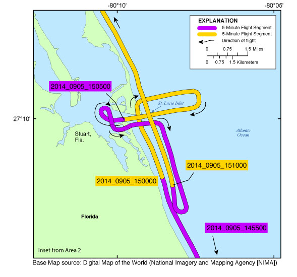
Browse_Graphic_File_Description:
St. Lucie inset map (Area 2). Map showing flight path of coastal oblique aerial photographs at St. Lucie Inlet, Stuart, Florida, on September 05, 2014. Purple and yellow colored lines correspond to 5-minute flight segments that link to contact sheets of associated photo thumbnails. Click on the 5-minute segment name to view each contact sheet.
Browse_Graphic_File_Type: JPEG
Browse_Graphic:
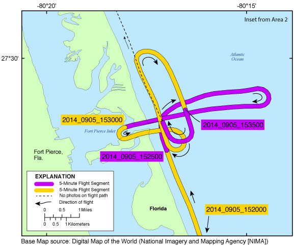
Browse_Graphic_File_Name: http://pubs.usgs.gov/ds/0953/maps/inset05_fortpierce.jpg
Browse_Graphic_File_Description:
Fort Pierce inset map (Area 2). Map showing flight path of coastal oblique aerial photographs at Fort Pirece Inlet, Fort Pierce, Florida, on September 05, 2014. Purple and yellow colored lines correspond to 5-minute flight segments that link to contact sheets of associated photo thumbnails. Click on the 5-minute segment name to view each contact sheet.
Browse_Graphic_File_Type: JPEG
Browse_Graphic:
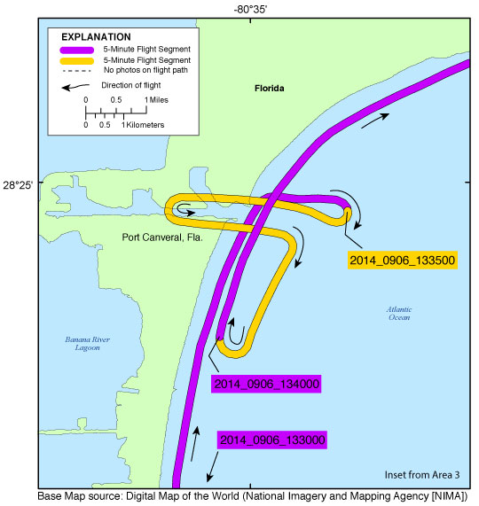
Browse_Graphic_File_Name: http://pubs.usgs.gov/ds/0953/maps/inset06_portcanaveral.jpg
Browse_Graphic_File_Description:
Port Canaveral inset map (Area 3). Map showing flight path of coastal oblique aerial photographs from Cape Canaveral, Florida, to the Kennedy Space Center, Florida, on September 06, 2014. Purple and yellow colored lines correspond to 5-minute flight segments that link to contact sheets of associated photo thumbnails. Click on the 5-minute segment name to view each contact sheet.
Browse_Graphic_File_Type: JPEG
Browse_Graphic:
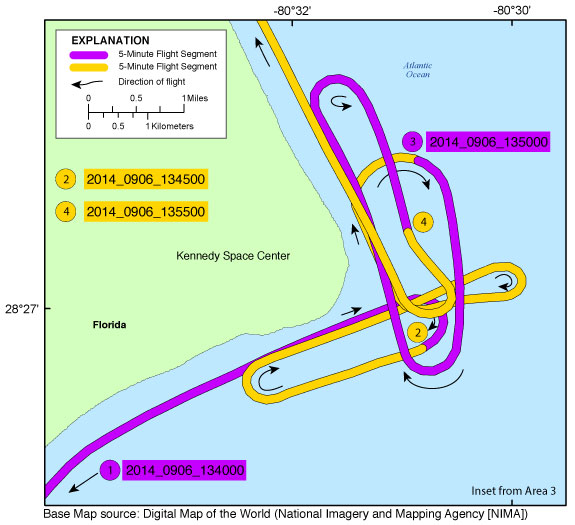
Browse_Graphic_File_Name: http://pubs.usgs.gov/ds/0953/maps/inset07_kennedy.jpg
Browse_Graphic_File_Description:
Kennedy Space Center, Cape Area inset map (Area 3). Map showing flight path of coastal oblique aerial photographs showing the cape at the Kennedy Space Center, Florida, on September 06, 2014. Purple and yellow colored lines correspond to 5-minute flight segments that link to contact sheets of associated photo thumbnails. Click on the 5-minute segment name to view each contact sheet.
Browse_Graphic_File_Type: JPEG
Browse_Graphic:
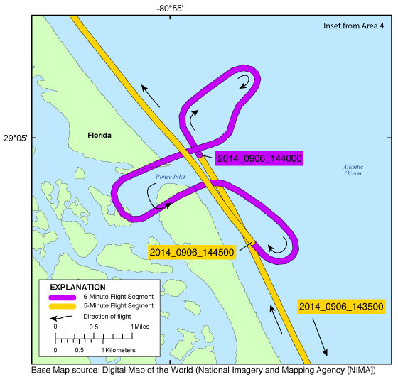
Browse_Graphic_File_Name: http://pubs.usgs.gov/ds/0953/maps/inset08_ponce.jpg
Browse_Graphic_File_Description:
Ponce Inlet inset map (Area 4). Map showing flight path of coastal oblique aerial photographs at Ponce Inlet, New Smyrna Beach, Florida, on September 06, 2014. Purple and yellow colored lines correspond to 5-minute flight segments that link to contact sheets of associated photo thumbnails. Click on the 5-minute segment name to view each contact sheet.
Browse_Graphic_File_Type: JPEG
Browse_Graphic:
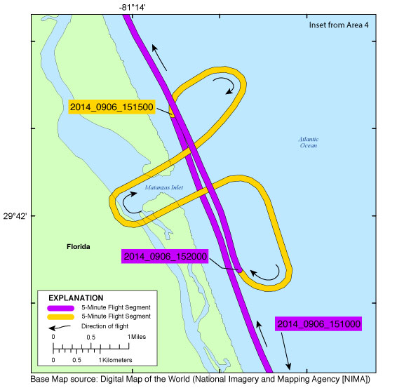
Browse_Graphic_File_Name: http://pubs.usgs.gov/ds/0953/maps/inset09_matanzas.jpg
Browse_Graphic_File_Description:
Matanzas Inlet inset map (Area 4). Map showing flight path of coastal oblique aerial photographs at Matanzas Inlet, St. Augustine, Florida, on September 06, 2014. Purple and yellow colored lines correspond to 5-minute flight segments that link to contact sheets of associated photo thumbnails. Click on the 5-minute segment name to view each contact sheet.
Browse_Graphic_File_Type: JPEG
Browse_Graphic:
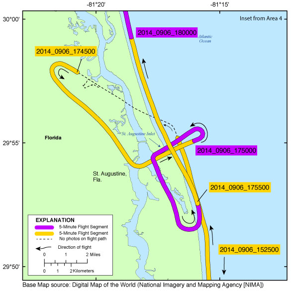
Browse_Graphic_File_Name: http://pubs.usgs.gov/ds/0953/maps/inset10_staugustine.jpg
Browse_Graphic_File_Description:
St. Augustine Inlet inset map (Area 4). Map showing flight path of coastal oblique aerial photographs at St. Augustine Inlet, St. Augustine, Florida, on September 06, 2014. Purple and yellow colored lines correspond to 5-minute flight segments that link to contact sheets of associated photo thumbnails. Click on the 5-minute segment name to view each contact sheet.
Browse_Graphic_File_Type: JPEG
Browse_Graphic:
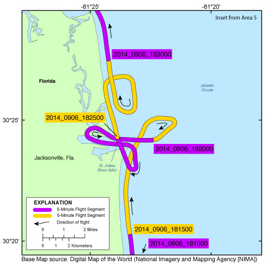
Browse_Graphic_File_Name: http://pubs.usgs.gov/ds/0953/maps/inset11_stjohns.jpg
Browse_Graphic_File_Description:
St. Johns River Inlet inset map (Area 5). Map showing flight path of coastal oblique aerial photographs the St. Johns River Inlet, Jacksonville, Florida, on September 06, 2014. Purple and yellow colored lines correspond to 5-minute flight segments that link to contact sheets of associated photo thumbnails. Click on the 5-minute segment name to view each contact sheet.
Browse_Graphic_File_Type: JPEG
Data_Set_Credit:
Funding and (or) support for this study was provided by the USGS Coastal and Marine Geology Program (CMGP). The author wishes to thank pilot, George McPherson, and Top Cover Virginia, LLC. owners Leo and Carol McManus for their assistance in data collection.