Citation:
Citation_Information:
Originator: Karynna Calderon
Originator: Shawn V. Dadisman
Originator: Jack L. Kindinger
Originator: James G. Flocks
Originator: Dana S. Wiese
Originator: Mark Kulp
Originator: Shea Penland
Originator: Louis D. Britsch
Originator: Gregg R. Brooks
Publication_Date: 2003
Title:
Archive of Chirp Seismic Reflection Data Collected During USGS Cruises 00SCC02 and 00SCC04, Barataria Basin, Louisiana, May 12-31 and June 17 - July 2, 2000
Geospatial_Data_Presentation_Form: Seismic Reflection Profile Section
Series_Information:
Series_Name: U.S. Geological Survey Open-File Report
Issue_Identification: 03-156
Publication_Information:
Publication_Place: St. Petersburg, FL
Publisher: U.S. Geological Survey
Online_Linkage: http://pubs.usgs.gov/of/2003/of03-156/
Description:
Abstract:
This archive consists of two-dimensional marine seismic reflection profile data collected in the Barataria Basin of southern Louisiana. These data were acquired in May, June, and July of 2000 aboard the R/V G.K. Gilbert. Included here are data in a variety of formats including binary, American Standard Code for Information Interchange (ASCII), Hyper-Text Markup Language (HTML), shapefiles, and Graphics Interchange Format (GIF) and Joint Photographic Experts Group (JPEG) images. Binary data are in Society of Exploration Geophysicists (SEG) SEG-Y format and may be downloaded for further processing or display. Reference maps and GIF images of the profiles may be viewed with a web browser. The Geographic Information Systems (GIS) information provided here is compatible with Environmental Systems Research Institute (ESRI) GIS software.
For more information on the seismic surveys see
http://walrus.wr.usgs.gov/infobank/g/g100la/html/g-1-00-la.meta.html and
http://walrus.wr.usgs.gov/infobank/g/g500la/html/g-5-00-la.meta.html
These data are also available via GeoMapApp (
http://www.geomapapp.org/) and Virtual Ocean (
http://www.virtualocean.org/) earth science exploration and visualization applications.
Marine seismic reflection data are used to image and map sedimentary and structural features of the seafloor and subsurface. These data are useful in mapping stratigraphy and in assessing other submarine geologic characteristics and features. These data were collected as part of a Louisiana Sand Resources Study done in cooperation with the U.S. Army Corps of Engineers, the University of New Orleans, the Louisiana Department of Natural Resources, and Eckerd College. This study is part of the U.S. Geological Survey (USGS) Subsidence and Coastal Change (SCC) project.
Supplemental_Information:
The USGS Center for Coastal and Watershed Studies team in St. Petersburg, FL, assigns a unique identifier to all seismic data collected during each cruise or field activity. The method used to assign the identifier for the cruise or field activity is as follows: YYPRO##, where YY stands for the last 2 digits of the year in which the fieldwork is conducted; PRO is a 3-digit acronym for the project the data are collected for; and ## is a 2-digit event tag that represents a discreet leg or time period of fieldwork. Here, 00SCC02 tells us the data were collected in the year 2000 for the Subsidence and Coastal Change Project and that the data were collected during the second field activity for that project in that calendar year. In order to conform to International Organization for Standardization (ISO) 9660 naming standards, the SEG-Y data files and associated navigation files were all renamed. Each trackline's original "bss" prefix was shortened to a single "b." For example, trackline "bss00c_01a" was renamed "b00c_01a." Seismic reflection profiles are acquired by means of an acoustic source (usually generated electronically) and hydrophone or receiver arrays. Both elements are typically towed in the water behind a survey vessel. The sound source emits a short acoustic pulse that propagates through the water and sediment column. The acoustic energy is reflected at density boundaries (such as the seafloor or sediment layers beneath the seafloor) and detected at the receiver. This process is repeated at intervals ranging between 100 milliseconds (ms) and 1 second (s) depending on the seismic source employed. In this way, a two-dimensional vertical image of the geologic structure beneath the ship track is constructed. The chirp system uses a source signal of continuously varying frequency. The seismic source employed consisted of an EdgeTech X-Star SB424 tow fish running Triton Elics FSSB software. The tow fish was routinely flown 2-5 m above the seafloor. Therefore, water depths shown on the chirp profiles are relative to the depth of the tow fish and not to sea level. Note that the raising or lowering of the tow fish during a survey (to avoid obstacles or follow relief) also produces a relative shift in the multiple reflections seen in the profile, which may be confused as a geologic feature. Any elevation change of the tow fish is recorded in the crew logbook. The fish was towed about 10 m behind the GPS antenna, and no correction for this offset has been made. The sample frequency of the data was 25 kilohertz (kHz), with a shot rate of every 0.25 s and a record length that varied between 20 and 32 ms. Refer to the GIF profile images for the exact record length of each trackline. Based on survey speeds of 3.5 - 4 knots, the shot spacing was about 0.5 m. For each recorded shot, three channels of trace data were collected. Channel 3 is the "real," or in-phase component of the signal, channel 2 is the "imaginary," or quadrative component of the signal, and channel 1 is the "envelope," or product of channels 2 and 3. Only channel 1 was used to produce the profiles presented here. However, all channels are included in the SEG-Y data files. No SEG-Y data exists for lines b00c_02, b00c_52, b00c_68 - b00c_72, and b00c_121 - b00c_124a. The original tracklines b00c_38, b00c_41, b00c_48, and b00c_66 were divided into b00c_38a and b; b00c_41a, b, and c; b00c_48a and b; and b00c_66a and b because the original total number of traces exceeds the maximum allowed by the processing system. Seismic data were stored in SEG-Y format, which is a standard digital format that can be read and manipulated by most seismic processing software packages. The SEG-Y file format includes a 3,200-byte descriptive header that contains detailed information regarding the data acquisition and processing parameters. All data presented here are stored in SEG-Y, integer, Motorola format. The SEG-Y data files are too large to fit on one Digital Versatile Disc (DVD), so they have been distributed onto four DVDs with the SEG-Y data files for lines b00c_01a - b00c_23 on Disc 1, lines b00c_24 - b00c_49 on Disc 2, lines b00c_50 - b00c_84 on Disc 3, and lines b00c_85 - b00c_120 on Disc 4. The SEG-Y formatted trace data files have a .TRA extension. Additional recording parameters for each seismic data file can also be found in the .PAR file associated with each .TRA file. However, the .PAR and .pln files are only needed to process or display the data with Triton Elics Delph Seismic software. Global Positioning System (GPS) navigation was provided to the acquisition system every second by a Trimble-Centurian P-Code receiver. The accuracy of this receiver is within 100 m. However, the data required some editing to remove spurious data values. The edited results were used to generate the trackline maps presented here. In addition, we have converted latitude and longitude to Zone 15 Universal Transverse Mercator (UTM) coordinates. The navigation data have not been corrected to reflect the 10 m offset between the source and the GPS antenna. Position fixes for every 1,000 shots and for the starts of lines are also provided as an aid for registering of the data after plotting. All navigation files are stored as flat ASCII text files. The trackline maps provided in this archive are in geographic projection. They were created using ESRI GIS software ArcView 3.2, exported to Adobe Illustrator for further editing, and saved for the web in JPEG format. These JPEG images are viewable with a web browser. Included on each disc are the ESRI ArcView project and shapefiles used to create the trackline maps presented here. The project is compatible with ArcView 3.x (Unix, Windows) and ArcGIS 8.x (Windows). The shapefiles can also be viewed using public domain software ArcExplorer 2.0 (Windows) and 4.0 (Windows, Unix, Linux), which can currently be downloaded from the ESRI website at <
http://www.esri.com/software/arcexplorer/index.html>. Field Activity Collection System (FACS) logs are available in both HTML and Rich Text Format (RTF). Scanned GIF images of the original handwritten logbooks are also provided. Also included on each disc are example Seismic Unix (SU) scripts that allow the user to strip off navigation fixes from the SEG-Y headers, along with a fix for every 1,000 shots, and produce a gained GIF image of each profile. These images can then be displayed using a variety of shareware programs such as ImageMagick (Unix, Linux) or a web browser.
Time_Period_of_Content:
Time_Period_Information:
Range_of_Dates/Times:
Beginning_Date: 20000512
Ending_Date: 20000702
Currentness_Reference: Data collection interval
Status:
Progress: Complete
Maintenance_and_Update_Frequency: None planned
Spatial_Domain:
Bounding_Coordinates:
West_Bounding_Coordinate: -90.212918
East_Bounding_Coordinate: -89.462507
North_Bounding_Coordinate: 29.431350
South_Bounding_Coordinate: 28.988922
Keywords:
Theme:
Theme_Keyword_Thesaurus: USGS Metadata Identifier
Theme_Keyword: USGS:e20970c1-01da-4563-897b-cd06f6092637
Theme:
Theme_Keyword_Thesaurus: None
Theme_Keyword: marine seismic reflection
Theme_Keyword: chirp
Theme_Keyword: 00SCC02
Theme_Keyword: 00SCC04
Theme_Keyword: SEG-Y
Theme_Keyword: Subsidence and Coastal Change Project
Theme_Keyword: Louisiana Sand Resources Study
Theme_Keyword: beach renourishment
Theme:
Theme_Keyword_Thesaurus: Data Categories for Marine Planning
Theme_Keyword: distributions
Theme_Keyword: substrate
Theme:
Theme_Keyword_Thesaurus: Marine Realms Information Bank (MRIB) Keywords
Theme_Keyword: seismic reflection
Theme_Keyword: marine geophysics
Theme:
Theme_Keyword_Thesaurus: USGS Thesaurus
Theme_Keyword: seismic reflection methods
Theme_Keyword: sub-bottom profiling
Theme_Keyword: marine geophysics
Place:
Place_Keyword_Thesaurus: None
Place_Keyword: Louisiana
Place_Keyword: Barataria Bay
Place_Keyword: Gulf of Mexico
Access_Constraints: None. These data are held in the public domain.
Use_Constraints:
The U.S. Geological Survey requests to be acknowledged as the originator of the data in future products or derivative research.
Point_of_Contact:
Contact_Information:
Contact_Person_Primary:
Contact_Person: Jack L. Kindinger
Contact_Organization: U.S. Geological Survey
Contact_Position: Oceanographer
Contact_Address:
Address_Type: mailing address
Address: 600 Fourth Street South
City: St. Petersburg
State_or_Province: FL
Postal_Code: 33701
Country: USA
Contact_Voice_Telephone: (727) 803-8747, ext. 3018
Contact_Electronic_Mail_Address: [email protected]
Browse_Graphic:
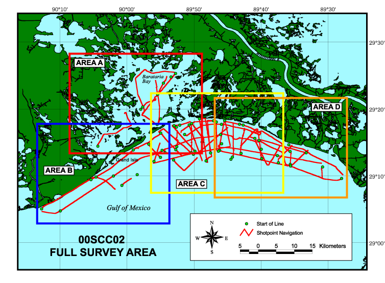
Browse_Graphic_File_Name: http://pubs.usgs.gov/of/2003/of03-156/maps/00scc02/02all.jpg
Browse_Graphic_File_Description:
Trackline map of all chirp seismic reflection data collected during USGS Cruise 00SCC02. These data were collected in the Barataria Basin of Louisiana in May of 2000. This map is in geographic projection and was created at a scale of 1:400,000 using ESRI GIS software ArcView 3.2. The image was exported to Adobe Illustrator for further editing and saved for the web in JPEG format.
Browse_Graphic_File_Type: JPEG
Browse_Graphic:
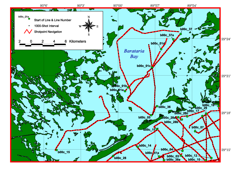
Browse_Graphic_File_Name: http://pubs.usgs.gov/of/2003/of03-156/maps/00scc02/02a.jpg
Browse_Graphic_File_Description:
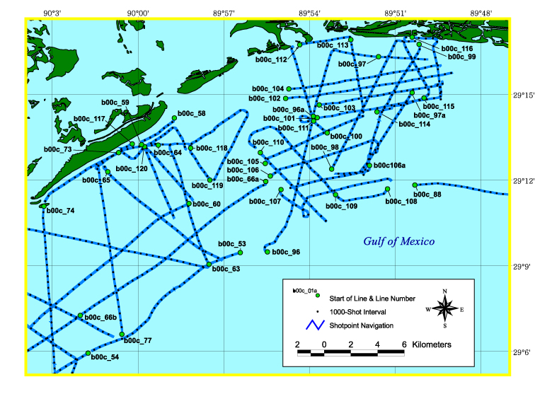
Trackline map of chirp seismic reflection data collected in Area A of Barataria Basin, Louisiana, during USGS Cruise 00SCC02 (refer to Area A of the full survey map) in May of 2000. This map is in geographic projection and was created at a scale of 1:150,000 using ESRI GIS software ArcView 3.2. The image was exported to Adobe Illustrator for further editing and saved for the web in JPEG format.
Browse_Graphic_File_Type: JPEG
Browse_Graphic:
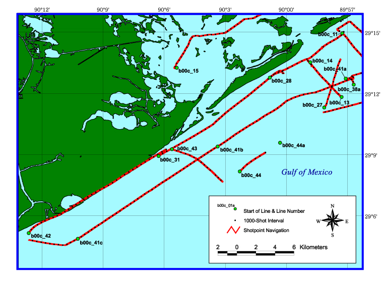
Browse_Graphic_File_Name: http://pubs.usgs.gov/of/2003/of03-156/maps/00scc02/02b.jpg
Browse_Graphic_File_Description:
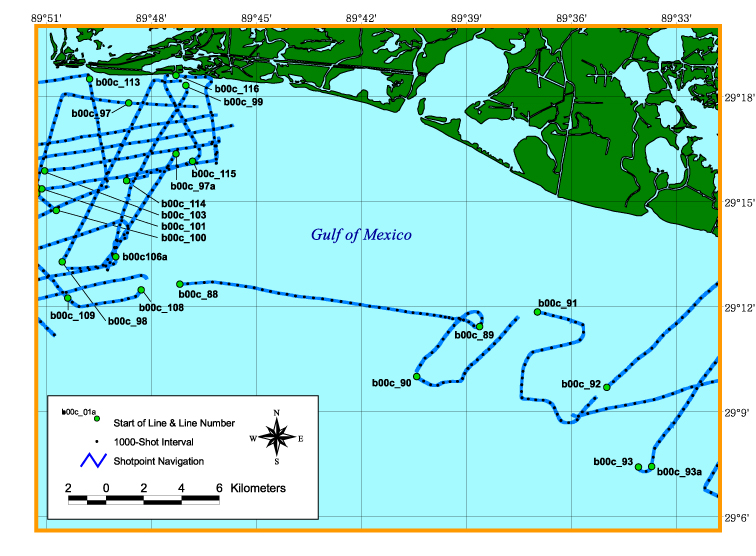
Trackline map of chirp seismic reflection data collected in Area B of Barataria Basin, Louisiana, during USGS Cruise 00SCC02 (refer to Area B of the full survey map) in May of 2000. This map is in geographic projection and was created at a scale of 1:150,000 using ESRI GIS software ArcView 3.2. The image was exported to Adobe Illustrator for further editing and saved for the web in JPEG format.
Browse_Graphic_File_Type: JPEG
Browse_Graphic:
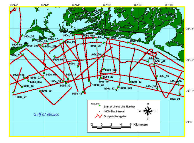
Browse_Graphic_File_Name: http://pubs.usgs.gov/of/2003/of03-156/maps/00scc02/02c.jpg
Browse_Graphic_File_Description:
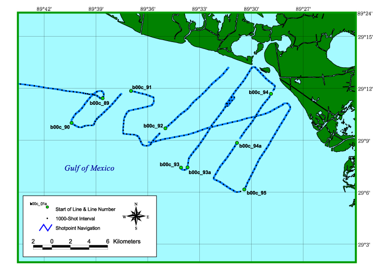
Trackline map of chirp seismic reflection data collected in Area C of Barataria Basin, Louisiana, during USGS Cruise 00SCC02 (refer to Area C of the full survey map) in May of 2000. This map is in geographic projection and was created at a scale of 1:150,000 using ESRI GIS software ArcView 3.2. The image was exported to Adobe Illustrator for further editing and saved for the web in JPEG format.
Browse_Graphic_File_Type: JPEG
Browse_Graphic:
Browse_Graphic_File_Name: http://pubs.usgs.gov/of/2003/of03-156/maps/00scc02/02d.jpg
Browse_Graphic_File_Description:
Trackline map of chirp seismic reflection data collected in Area D of Barataria Basin, Louisiana, during USGS Cruise 00SCC02 (refer to Area D of the full survey map) in May of 2000. This map is in geographic projection and was created at a scale of 1:150,000 using ESRI GIS software ArcView 3.2. The image was exported to Adobe Illustrator for further editing and saved for the web in JPEG format.
Browse_Graphic_File_Type: JPEG
Browse_Graphic:
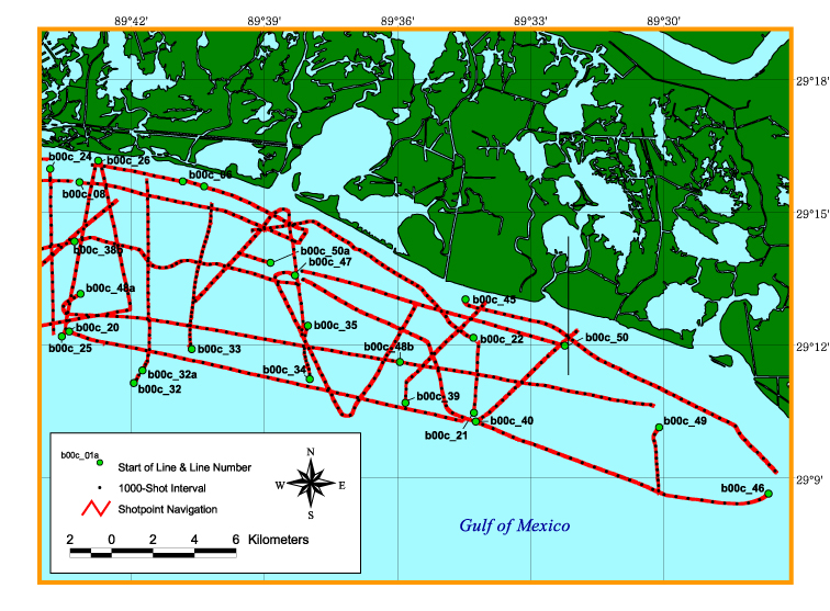
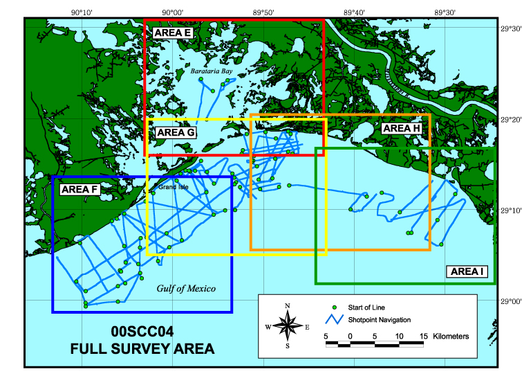
Browse_Graphic_File_Name: http://pubs.usgs.gov/of/2003/of03-156/maps/00scc04/04all.jpg
Browse_Graphic_File_Description:
Trackline map of all chirp seismic reflection data collected during USGS Cruise 00SCC04. These data were collected in the Barataria Basin of Louisiana in June and July of 2000. This map is in geographic projection and was created at a scale of 1:400,000 using ESRI GIS software ArcView 3.2. The image was exported to Adobe Illustrator for further editing and saved for the web in JPEG format.
Browse_Graphic_File_Type: JPEG
Browse_Graphic:
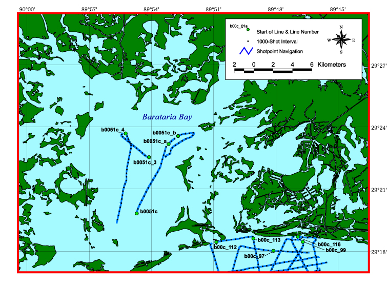
Browse_Graphic_File_Name: http://pubs.usgs.gov/of/2003/of03-156/maps/00scc04/04e.jpg
Browse_Graphic_File_Description:
Trackline map of chirp seismic reflection data collected in Area E of Barataria Basin, Louisiana, during USGS Cruise 00SCC04 (refer to Area E of the full survey map) in June and July of 2000. This map is in geographic projection and was created at a scale of 1:150,000 using ESRI GIS software ArcView 3.2. The image was exported to Adobe Illustrator for further editing and saved for the web in JPEG format.
Browse_Graphic_File_Type: JPEG
Browse_Graphic:
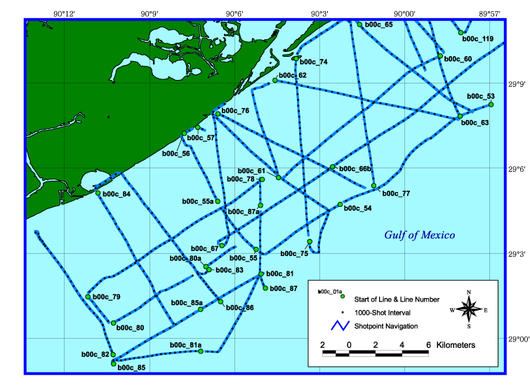
Browse_Graphic_File_Name: http://pubs.usgs.gov/of/2003/of03-156/maps/00scc04/04f.jpg
Browse_Graphic_File_Description:
Trackline map of chirp seismic reflection data collected in Area F of Barataria Basin, Louisiana, during USGS Cruise 00SCC04 (refer to Area F of the full survey map) in June and July of 2000. This map is in geographic projection and was created at a scale of 1:150,000 using ESRI GIS software ArcView 3.2. The image was exported to Adobe Illustrator for further editing and saved for the web in JPEG format.
Browse_Graphic_File_Type: JPEG
Browse_Graphic:
Browse_Graphic_File_Name: http://pubs.usgs.gov/of/2003/of03-156/maps/00scc04/04g.jpg
Browse_Graphic_File_Description:
Trackline map of chirp seismic reflection data collected in Area G of Barataria Basin, Louisiana, during USGS Cruise 00SCC04 (refer to Area G of the full survey map) in June and July of 2000. This map is in geographic projection and was created at a scale of 1:150,000 using ESRI GIS software ArcView 3.2. The image was exported to Adobe Illustrator for further editing and saved for the web in JPEG format.
Browse_Graphic_File_Type: JPEG
Browse_Graphic:
Browse_Graphic_File_Name: http://pubs.usgs.gov/of/2003/of03-156/maps/00scc04/04h.jpg
Browse_Graphic_File_Description:
Trackline map of chirp seismic reflection data collected in Area H of Barataria Basin, Louisiana, during USGS Cruise 00SCC04 (refer to Area H of the full survey map) in June and July of 2000. This map is in geographic projection and was created at a scale of 1:150,000 using ESRI GIS software ArcView 3.2. The image was exported to Adobe Illustrator for further editing and saved for the web in JPEG format.
Browse_Graphic_File_Type: JPEG
Browse_Graphic:
Browse_Graphic_File_Name: http://pubs.usgs.gov/of/2003/of03-156/maps/00scc04/04i.jpg
Browse_Graphic_File_Description:
Trackline map of chirp seismic reflection data collected in Area I of Barataria Basin, Louisiana, during USGS Cruise 00SCC04 (refer to Area I of the full survey map) in June and July of 2000. This map is in geographic projection and was created at a scale of 1:150,000 using ESRI GIS software ArcView 3.2. The image was exported to Adobe Illustrator for further editing and saved for the web in JPEG format.
Browse_Graphic_File_Type: JPEG
Data_Set_Credit:
Funding and/or support for this study were provided by the Coastal and Marine Geology Program (CMGP) of the USGS, the U.S. Army Corps of Engineers, the University of New Orleans, the Louisiana Department of Natural Resources, and Eckerd College. We thank Chandra A. Dreher of the USGS in St. Petersburg, FL, and Allison Peters, Carlos Alonzo, and Mike Brown of the University of New Orleans in New Orleans, LA, for their field support during data collection. Boat captains Dave Bennett of Eckerd College in St. Petersburg, FL, and Richard W. Young and Keith A. Ludwig of the USGS in St. Petersburg, FL, also assisted in data collection. We thank Gina M. Peery of the USGS in St. Petersburg, FL, for her work as FACS coordinator. We also thank reviewers Dann K. Yobbi of the USGS in Tampa, FL, and John C. Brock of the USGS in St. Petersburg, FL, whose comments improved this document.
Native_Data_Set_Environment: SEG-Y