Citation:
Citation_Information:
Originator: U.S. Geological Survey
Publication_Date: 2007
Title: EAARL Topography-Gulf Islands National Seashore-Mississippi
Edition: First
Geospatial_Data_Presentation_Form: vector digital data
Series_Information:
Series_Name: Open File Report
Issue_Identification: 2007-1377
Publication_Information:
Publication_Place: St. Petersburg, FL
Publisher: U. S. Geological Survey
Other_Citation_Details:
The U. S. Geological Survey, in cooperation with the National Park Service (NPS) and the National Aeronautics and Space Administration (NASA), is to provide the coastal management community with usable, useful digital elevation products. The USGS processes aircraft Lidar data (provided by NASA), develops software tools and algorithms to use and analyze the data and make products available to the coastal management community through a variety of media, including the internet, CD-ROMs, DVDs and data reports.
Online_Linkage: http://pubs.usgs.gov/of/2007/1377/start.html
Description:
Abstract:
Abstract: Elevation maps (also known as Digital Elevation Models or DEMs) of Gulf Islands National Seashore were produced from remotely-sensed, geographically-referenced elevation measurements in cooperation with NASA and NPS. Point data in ascii text files were interpolated in a GIS to create a grid or digital elevation model (DEM) of each beach surface. Elevation measurements were collected in Florida, Mississippi and Texas, over Gulf Islands National Seashore, using the NASA Experimental Advanced Airborne Research Lidar (EAARL), a pulsed laser ranging system mounted onboard an aircraft to measure ground elevation and coastal topography. The system uses high frequency laser beams directed at the earth's surface through an opening in the bottom of the aircraft's fuselage. The laser system records the time difference between emission of the laser beam and the reception of the reflected laser signal in the aircraft. The plane travels over the beach at approximately 60 meters per second while surveying from the low-water line to the landward base of the sand dunes. The EAARL, developed by the National Aeronautics and Space Administration (NASA) located at Wallops Flight Facility in Virginia, measures ground elevation with a vertical resolution of 15 centimeters. A sampling rate of 3 kHz or higher results in an extremely dense spatial elevation data set. Over 100 kilometers of coastline can be easily surveyed within a 3- to 4-hour mission time period. The ability to sample large areas rapidly and accurately is especially useful in morphologically dynamic areas such as barrier beaches. Quick assessment of topographic change can be made following storms comparing measurements against baseline data. When subsequent elevation maps for an area are analyzed, they provide a useful tool to make management decisions regarding coastal development.
For more information on Lidar science and the Experimental Advanced Airborne Research Lidar (EAARL) system and surveys, see
http://ngom.usgs.gov/dsp/overview/index.php and
http://ngom.usgs.gov/dsp/tech/eaarl/index.php .
One goal of the Project is to produce highly detailed and accurate digital elevation maps (DEMs) of National Seashores and coastal parks for use as a management tool and to make these maps available to natural resource managers within the parks.
Supplemental_Information:
Raw Lidar data is not in a format that is generally usable by Park Service resource managers and scientists for scientific analysis. Converting dense Lidar elevation data into a readily usable format without loss of essential information requires specialized processing. The U. S. Geological Survey converts raw Lidar data into a GIS-compatible map product to be provided to Park Service GIS specialists, managers, and scientists. The primary tool used in the conversion process is Airborne Lidar Processing System (ALPS), a multitiered processing system developed by a USGS/NASA collaborative for the use of topographic Lidar in coastal change assessment. Specialized processing algorithms are used to convert raw waveform Lidar data acquired by the EAARL to georeferenced spot (x,y,z) returns for "first surface" and "bare earth" topography. These data are then converted to the NAD83 horizontal and NAVD88 vertical datum (using the Geoid 99 model). The final products are 2x2-km map tiles written out in a standard geotiff format with associated metadata information. These tiles are created for visual interpretation and regional quantitative analysis. Metadata files include the standard FGDC format.See the source Lidar GeoTIFF tile for more specific accuracy information.
Time_Period_of_Content:
Time_Period_Information:
Multiple_Dates/Times:
Single_Date/Time:
Calendar_Date: 20050901
Single_Date/Time:
Calendar_Date: 20050903
Single_Date/Time:
Calendar_Date: 20050904
Single_Date/Time:
Calendar_Date: 20050907
Single_Date/Time:
Calendar_Date: 20050908
Currentness_Reference: ground condition
Status:
Progress: Complete
Maintenance_and_Update_Frequency: Unknown
Spatial_Domain:
Bounding_Coordinates:
West_Bounding_Coordinate: -70.313
East_Bounding_Coordinate: -69.911
North_Bounding_Coordinate: 42.156
South_Bounding_Coordinate: 41.602
Keywords:
Theme:
Theme_Keyword_Thesaurus: USGS Metadata Identifier
Theme_Keyword: USGS:41cba093-5f20-445a-8a16-323da7c4d1a3
Theme:
Theme_Keyword_Thesaurus: ISO 19115 Topic Category
Theme_Keyword: elevation
Theme:
Theme_Keyword_Thesaurus: None
Theme_Keyword: Lidar
Theme_Keyword: Experimental Advanced Airborne Research Lidar
Theme_Keyword: digital elevation model
Theme_Keyword: elevation change
Theme_Keyword: laser altimetry
Theme_Keyword: derived surface
Theme_Keyword: resource management
Theme_Keyword: bare earth elevation
Theme_Keyword: ALPS
Theme_Keyword: Airborne Lidar Processing System
Theme:
Theme_Keyword_Thesaurus: Data Categories for Marine Planning
Theme_Keyword: distributions
Theme_Keyword: bathymetry and elevation
Theme:
Theme_Keyword_Thesaurus: Marine Realms Information Bank (MRIB) Keywords
Theme_Keyword: altimetry
Theme_Keyword: topographic mapping
Theme:
Theme_Keyword_Thesaurus: USGS Thesaurus
Theme_Keyword: LIDAR
Theme_Keyword: topography
Theme_Keyword: digital elevation models
Place:
Place_Keyword_Thesaurus: None
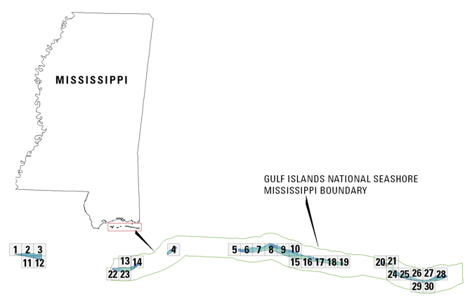
Place_Keyword: Gulf Islands National Seashore
Place_Keyword: Mississippi
Place_Keyword: Gulf of Mexico
Stratum:
Stratum_Keyword_Thesaurus: None
Stratum_Keyword: bare earth topography
Access_Constraints:
Any use of these data signifies a user's agreement to comprehension and compliance of the U. S. Geological Survey's Standard Disclaimer. Ensure all portions of metadata are read and clearly understood before using these data in order to protect both user and USGS interests. See section 6.3 Distribution Liability.
Use_Constraints:
Although the U. S. Geological Survey is making these data sets available to others who may find the data of value, the U. S. Geological Survey does not warrant, endorse, or recommend the use of these data setse for any given purpose. The user assumes the entire risk related to the use of these data. These data sets are not for navigational purposes. The U. S. Geological Survey is providing these data "as is", and the U. S. Geological Survey disclaims any and all warranties, whether expressed or implied, including (without limitation) any implied warranties of merchantability or fitness for a particular purpose. In no event will the USGS be liable to you or to any third party for any direct, indirect, incidental, consequential, special, or exemplary damages or lost profits resulting from any use or misuse of these data.Acknowledgement of the U.S. Geological Survey, FISC St. Petersburg office, as a data source would be appreciated in products developed from these data, and such acknowledgement as is standard for citation and legal practices for data source is expected by users of this data. Sharing new data layers developed directly from these data would also be appreciated by the USGS staff. Users should be aware that comparisons with other data sets for the same area from other time periods may be inaccurate due to inconsistencies resulting from changes in photo interpretation, mapping conventions, and digital processes over time. These data are not legal documents and are not to be used as such.
Point_of_Contact:
Contact_Information:
Contact_Organization_Primary:
Contact_Organization: U. S. Geological Survey, FISC St. Petersburg
Contact_Address:
Address_Type: mailing and physical address
Address: 600 4th Street South
City: St. Petersburg
State_or_Province: FL
Postal_Code: 33701
Country: USA
Contact_Voice_Telephone: 727 803-8747
Hours_of_Service: 8:30-5:00 M-F EST
Contact_Instructions: Call Survey for Details
Browse_Graphic:
Data_Set_Credit:
The U. S. Geological Surveyy, FISC St. Petersburg office, would like to acknowledge NASA Goddard Space Flight Center for their cooperation and assistance in the development of the data. The USGS would also like to acknowledge National Park Service management and personnel at Gulf Islands National Seashore.
Native_Data_Set_Environment:
Microsoft Windows XP Version 5.1 (Build 2600) Service Pack 2; ESRI ArcMap 9.2.0 1324