usSEABED CaLCulated data for the entire U.S. Gulf of Mexico and Caribbean (GMX_CLC, Puerto Rico and U.S. Virgin Islands)

Metadata also available as - [Questions & Answers] - [Parseable text] - [XML]

Metadata:

Identification_Information:
Citation:
Citation_Information:
Originator: U.S. Geological Survey
Originator: University of Colorado
Publication_Date: 2006
Title:
usSEABED CaLCulated data for the entire U.S. Gulf of Mexico and Caribbean (GMX_CLC, Puerto Rico and U.S. Virgin Islands)
Edition: 1.0
Geospatial_Data_Presentation_Form: vector digital data
Series_Information:
Series_Name: Data Series
Issue_Identification: 146
Publication_Information:
Publication_Place: Woods Hole Coastal and Marine Science Center, Woods Hole, MA
Publisher: U.S. Geological Survey, Coastal and Marine Geology Program
Online_Linkage: https://doi.org/10.3133/ds146
Online_Linkage: https://pubs.usgs.gov/ds/2006/146/htmldocs/data_cata.htm
Online_Linkage: https://pubs.usgs.gov/ds/2006/146/data/gmx_clc.zip
Larger_Work_Citation:
Citation_Information:
Originator: B.J. Buczkowski
Originator: J.A. Reid
Originator: C.J. Jenkins
Originator: J.M. Reid
Originator: S.J. Williams
Originator: J.G. Flocks
Publication_Date: 2006
Title:
usSEABED: Gulf of Mexico and Caribbean (Puerto Rico and U.S. Virgin Islands) Offshore Surficial Sediment Data Release
Edition: 1.0
Series_Information:
Series_Name: Data Series
Issue_Identification: 146
Publication_Information:
Publication_Place: Reston, VA
Publisher: U.S. Geological Survey
Online_Linkage: https://pubs.usgs.gov/ds/2006/146/
Description:
Abstract:
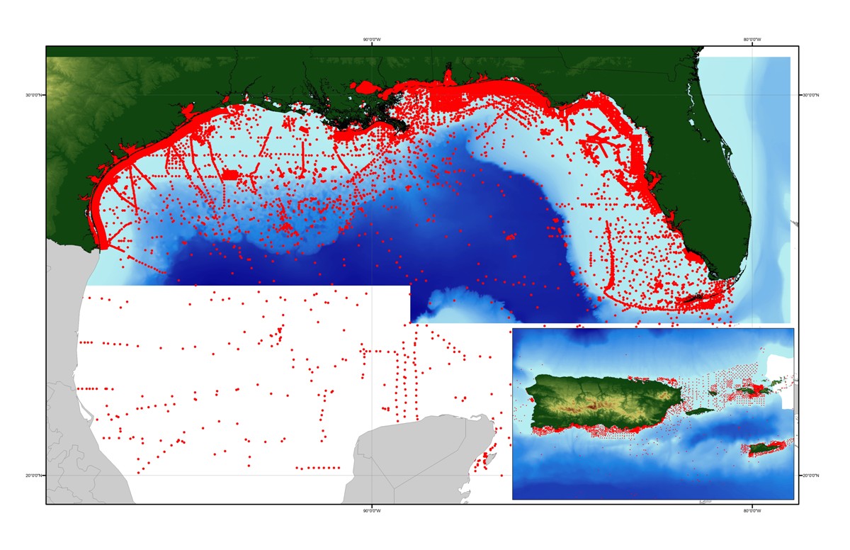
This data layer is a point coverage of known sediment samplings, inspections and probings from the usSEABED data collection and integrated using the software system dbSEABED. This data layer represents the calculated (CLC) output of the dbSEABED mining software. It contains results from calculating variables using empirical functions working on the results of extraction or parsing. The CLC data is the most derivative and certainly the least accurate; however, many clients appreciate that it extends the coverage of map areas with attributes, especially physical properties attributes.
Purpose:
To build a digital mapping of the character of the seabed on regional, national and global scales. These data are intended for science researchers, students, policy makers, and the general public. The data can be used with geographic information systems (GIS) software to display geologic and oceanographic information.
Time_Period_of_Content:
Time_Period_Information:
Single_Date/Time:
Calendar_Date: 2006
Currentness_Reference: publication date
Status:
Progress: In work
Maintenance_and_Update_Frequency: As needed
Spatial_Domain:
Bounding_Coordinates:
West_Bounding_Coordinate: -97.949450
East_Bounding_Coordinate: -63.800000
North_Bounding_Coordinate: 30.808300
South_Bounding_Coordinate: 16.666670
Keywords:
Theme:
Theme_Keyword_Thesaurus: USGS Metadata Identifier
Theme_Keyword: USGS:451a6607-e24d-4fac-8f37-6022a54ba20e
Theme:
Theme_Keyword_Thesaurus: None
Theme_Keyword: analyses
Theme_Keyword: CMGP
Theme_Keyword: Coastal and Marine Geology Program
Theme_Keyword: dbSEABED
Theme_Keyword: descriptions
Theme_Keyword: geology
Theme_Keyword: grain size
Theme_Keyword: Marine Aggregates Resources and Processes
Theme_Keyword: seabed
Theme_Keyword: seafloor
Theme_Keyword: sediment data
Theme_Keyword: texture
Theme_Keyword: U.S. Geological Survey
Theme_Keyword: usSEABED
Theme_Keyword: Woods Hole Science Center
Theme_Keyword: University of Colorado
Theme_Keyword: Institute of Arctic and Alpine Research
Theme_Keyword: Benthic Habitats (Pacific) Project
Theme_Keyword: Pacific Science Center
Theme_Keyword: WHSC
Theme_Keyword: PSC
Theme_Keyword: INSTAAR
Theme_Keyword: USGS
Theme:
Theme_Keyword_Thesaurus: ISO 19115 Topic Category
Theme_Keyword: oceans
Theme_Keyword: location
Theme_Keyword: geoscientificInformation
Theme:
Theme_Keyword_Thesaurus: Coastal and Marine Ecological Classification Standard (CMECS)
Theme_Keyword: Marine Nearshore
Theme_Keyword: Marine Offshore
Theme_Keyword: Estuarine Coastal
Theme_Keyword: Continental/Island Shelf
Theme_Keyword: Continental/Island Slope
Theme_Keyword: Unconsolidated Mineral Substrate
Theme:
Theme_Keyword_Thesaurus: Data Categories for Marine Planning
Theme_Keyword: distributions
Theme_Keyword: sand resources
Theme_Keyword: substrate
Theme:
Theme_Keyword_Thesaurus: Marine Realms Information Bank (MRIB) Keywords
Theme_Keyword: seabed
Theme_Keyword: sediment resources
Theme_Keyword: sand deposit
Theme:
Theme_Keyword_Thesaurus: USGS Thesaurus
Theme_Keyword: sea-floor characteristics
Theme_Keyword: nonmetallic mineral resources
Theme_Keyword: gravel deposits
Theme_Keyword: sand deposits
Place:
Place_Keyword_Thesaurus: None
Place_Keyword: Gulf of Mexico
Place_Keyword: U.S. Gulf Coast
Place_Keyword: United States
Place_Keyword: Caribbean Sea
Place_Keyword: Puerto Rico
Place_Keyword: U.S. Virgin Islands
Place:
Place_Keyword_Thesaurus: Coastal and Marine Ecological Classification Standard (CMECS)
Place_Keyword: Floridian Ecoregion
Place_Keyword: Northern Gulf of Mexico Ecoregion
Place_Keyword: Greater Antilles Ecoregion
Stratum:
Stratum_Keyword_Thesaurus: Coastal and Marine Ecological Classification Standard (CMECS)
Stratum_Keyword: Substrate
Access_Constraints: None
Use_Constraints:
Public domain data from the U.S. Government are freely redistributable with proper metadata and source attribution. Please recognize the U.S. Geological Survey (USGS) as the source of this information.
Point_of_Contact:
Contact_Information:
Contact_Person_Primary:
Contact_Person: Brian Buczkowski
Contact_Organization: U.S. Geological Survey
Contact_Position: Core Curator and Data Management Specialist
Contact_Address:
Address_Type: mailing and physical address
Address: 384 Woods Hole Road
City: Woods Hole
State_or_Province: MA
Postal_Code: 02543-1598
Country: USA
Contact_Voice_Telephone: (508) 548-8700 x2361
Contact_Facsimile_Telephone: (508) 457-2310
Contact_Electronic_Mail_Address: bbuczkowski@usgs.gov
Browse_Graphic:
Browse_Graphic_File_Name: https://pubs.usgs.gov/ds/2006/146/data/gmx_clc.jpg
Browse_Graphic_File_Description: Image map showing extent of data layer coverage
Browse_Graphic_File_Type: JPEG
Data_Set_Credit:
We thank the following interns for their assistance in data entry, coding, and data testing: Viness Ubert, Emma Mitchell, Emily Denham ,Shea Quinn and Ariadne Prior-Grosch.
Native_Data_Set_Environment:
Microsoft Windows XP Version 5.1 (Build 2600) Service Pack 2; ESRI ArcCatalog 9.1.0.722
Data_Quality_Information:
Attribute_Accuracy:
Attribute_Accuracy_Report:
Accuracy of each attribute is dependent on the accuracy of the lineage data.
Logical_Consistency_Report:
Data in usSEABED are based on the observations and analyses of others, filtered through a unifying and mining software. Each source report varies in type of information/data recorded and format. Only those observations that are recorded can be filtered and mined; only presence (not absence) or information can be noted.
Completeness_Report:
Additional useable data may exist in this area; the authors appreciate any information and leads.
Positional_Accuracy:
Horizontal_Positional_Accuracy:
Horizontal_Positional_Accuracy_Report:
Locational accuracy is dependent on the accuracy of the navigational technique from the individual data sources and may vary widely (e.g., from 0.005km (differential GPS) in more recent surveys to greater than 2 km based on radar, Loran, or dead reckoning in older surveys.) Users of the data should use their own criteria for assessing the accuracy of the locations.
Vertical_Positional_Accuracy:
Vertical_Positional_Accuracy_Report:
Locational accuracy is dependent on the accuracy of the navigational technique from the individual data sources. Users of the data should use their own criteria for assessing the accuracy of the locations.
Lineage:
Source_Information:
Source_Citation:
Citation_Information:
Originator: Various
Publication_Date: unknown
Title:
See separate listing, GMX_SRC.txt, contained within the Larger_Work_Citation for specific sources and associated metadata
Geospatial_Data_Presentation_Form: Hard copy documents and digital files
Other_Citation_Details:
X number of sources, both published and unpublished, are used as the sources of information for usSEABED. Metadata for each source is linked through the usSEABED source file (GMX_SRC.txt). Sources include the U.S. Geological Survey (USGS), the U.S. Army Corps of Engineers (USACE), Minerals Management Service (MMS), National X number of sources, both published and unpublished, are used as the sources of information for usSEABED. Metadata for each source is linked through the usSEABED source file (GMX_SRC.txt). Sources include the U.S. Geological Survey (USGS), the U.S. Army Corps of Engineers (USACE), Minerals Management Service (MMS), National Oceanic and Atmospheric Administration (NOAA), Virginia Institute of Marine Science (VIMS), the Maryland and New Jersey State Geological Surveys (MGS, NJGS), NOAA's National Geophysical Data Center (NGDC), the Smithsonian Institution, and others.
Type_of_Source_Media: various hard copy documents and digital files
Source_Time_Period_of_Content:
Time_Period_Information:
Single_Date/Time:
Calendar_Date: unknown
Source_Currentness_Reference: unknown
Source_Citation_Abbreviation: varies with source
Source_Contribution:
point locations, descriptions and analytical data on many different types of sediment and rock materials and benthos
Process_Step:
Process_Description:
Source data may be digitized as necessary (typed or scanned in), with a visual inspection of digitized data to the source report and corrections as necessary, and are tested for completeness in Microsoft Excel as appropriate. Other digital data may be decoded using source-specific programs, downloaded via the web, or sent directly to the USGS or University of Colorado via email. Data are formatted into the dbSEABED Data Entry template (db9_DataEntry.xls, version 08/07/2004) by hand, and tested using the dbSEABED relational database program (RDBi, version 01/05/2006) for correctness of formatting. Data are compiled into source data resource files (DRF) and processed through the dbSEABED data mining program (MNEt, version 04/07/2006) program, using the dbSEABED thesaurus (db9_dct.rtf, version 04/07/2006) and facies set up file for U.S. waters (db9_FAC.txt, version 04/07/2006). Data are iteratively reprocessed and corrected until noted errors are fixed, as recorded by the _RBDS.2fx and _MNE.DGN files. Data are exercised in a GIS for location tests and useability. Please review the Larger_Work_Citation for information about how the data are compiled, integrated, and processed in the usSEABED database.
Source_Used_Citation_Abbreviation: GMX_CLC.txt
Process_Date: 2006
Source_Produced_Citation_Abbreviation: gmx_clc.dbf
Source_Produced_Citation_Abbreviation: gmx_clc.shp
Source_Produced_Citation_Abbreviation: gmx_clc.shx
Process_Contact:
Contact_Information:
Contact_Organization_Primary:
Contact_Organization: U.S. Geological Survey
Contact_Person: Brian J. Buczkowski
Contact_Position: Core Curator and Data Management Specialist
Contact_Address:
Address_Type: Mail and Physical
Address: 384 Woods Hole Road
City: Woods Hole
State_or_Province: MA
Postal_Code: 02543-1598
Country: USA
Contact_Voice_Telephone: (508) 548-8700 x2361
Contact_Facsimile_Telephone: (508) 457-2310
Contact_Electronic_Mail_Address: bbuczkowski@usgs.gov
Contact_Instructions: email preferred
Process_Step:
Process_Description:
Edits to the metadata were made to fix any errors that MP v 2.9.36 flagged. This is necessary to enable the metadata to be successfully harvested for various data catalogs. In some cases, this meant adding text "Information unavailable" or "Information unavailable from original metadata" for those required fields that were left blank. Other minor edits were probably performed (title, publisher, publication place, etc.). In attributes with range domains, a value of 9999 was entered in the minimum and maximum values to indicate the original metadata did not contain the required information. Minor fixes to the attribute format for some attributes were needed. Attempted to modify http to https where appropriate. The metadata date (but not the metadata creator) was edited to reflect the date of these changes. The metadata available from a harvester may supersede metadata bundled within a download file. Compare the metadata dates to determine which metadata file is most recent.
Process_Date: 20170126
Process_Contact:
Contact_Information:
Contact_Organization_Primary:
Contact_Organization: U.S. Geological Survey
Contact_Person: VeeAnn A. Cross
Contact_Position: Marine Geologist
Contact_Address:
Address_Type: Mailing and Physical
Address: 384 Woods Hole Road
City: Woods Hole
State_or_Province: MA
Postal_Code: 02543-1598
Contact_Voice_Telephone: 508-548-8700 x2251
Contact_Facsimile_Telephone: 508-457-2310
Contact_Electronic_Mail_Address: vatnipp@usgs.gov
Process_Step:
Process_Description:
Keywords added to metadata support discovery in the USGS Coastal and Marine Geology Data Catalog.
Process_Date: 20180426
Process_Contact:
Contact_Information:
Contact_Organization_Primary:
Contact_Organization: U.S. Geological Survey
Contact_Person: Alan O. Allwardt
Contact_Position: Contractor -- Information Specialist
Contact_Address:
Address_Type: mailing and physical address
Address: 2885 Mission Street
City: Santa Cruz
State_or_Province: CA
Postal_Code: 95060
Contact_Voice_Telephone: 831-460-7551
Contact_Facsimile_Telephone: 831-427-4748
Contact_Electronic_Mail_Address: aallwardt@usgs.gov
Process_Step:
Process_Description: Crossref DOI link was added as the first link in the metadata.
Process_Date: 20191115
Process_Contact:
Contact_Information:
Contact_Organization_Primary:
Contact_Organization: U.S. Geological Survey
Contact_Person: VeeAnn A. Cross
Contact_Position: Marine Geologist
Contact_Address:
Address_Type: Mailing and Physical
Address: 384 Woods Hole Road
City: Woods Hole
State_or_Province: MA
Postal_Code: 02543-1598
Contact_Voice_Telephone: 508-548-8700 x2251
Contact_Facsimile_Telephone: 508-457-2310
Contact_Electronic_Mail_Address: vatnipp@usgs.gov
Process_Step:
Process_Description:
Added keywords section with USGS persistent identifier as theme keyword.
Process_Date: 20200908
Process_Contact:
Contact_Information:
Contact_Organization_Primary:
Contact_Organization: U.S. Geological Survey
Contact_Person: VeeAnn A. Cross
Contact_Position: Marine Geologist
Contact_Address:
Address_Type: Mailing and Physical
Address: 384 Woods Hole Road
City: Woods Hole
State_or_Province: MA
Postal_Code: 02543-1598
Contact_Voice_Telephone: 508-548-8700 x2251
Contact_Facsimile_Telephone: 508-457-2310
Contact_Electronic_Mail_Address: vatnipp@usgs.gov
Spatial_Data_Organization_Information:
Direct_Spatial_Reference_Method: Vector
Point_and_Vector_Object_Information:
SDTS_Terms_Description:
SDTS_Point_and_Vector_Object_Type: Entity point
Point_and_Vector_Object_Count: 75838
Spatial_Reference_Information:
Horizontal_Coordinate_System_Definition:
Geographic:
Latitude_Resolution: 0.00001
Longitude_Resolution: 0.00001
Geographic_Coordinate_Units: Decimal degrees
Geodetic_Model:
Horizontal_Datum_Name: D_WGS_1984
Ellipsoid_Name: WGS_1984
Semi-major_Axis: 6378137.000000
Denominator_of_Flattening_Ratio: 298.257224
Entity_and_Attribute_Information:
Detailed_Description:
Entity_Type:
Entity_Type_Label: gmx_clc
Entity_Type_Definition: Shapefile Attribute Table
Entity_Type_Definition_Source: ESRI
Attribute:
Attribute_Label: FID
Attribute_Definition: Internal feature number.
Attribute_Definition_Source: ESRI
Attribute_Domain_Values:
Unrepresentable_Domain:
Sequential unique whole numbers that are automatically generated.
Attribute:
Attribute_Label: Shape
Attribute_Definition: Feature geometry.
Attribute_Definition_Source: ESRI
Attribute_Domain_Values:
Unrepresentable_Domain: Coordinates defining the features.
Attribute:
Attribute_Label: LATITUDE
Attribute_Definition: Latitude coordinate of sample location
Attribute_Definition_Source: USGS
Attribute_Domain_Values:
Range_Domain:
Range_Domain_Minimum: 16.66667
Range_Domain_Maximum: 30.80830
Attribute_Units_of_Measure: decimal degrees
Attribute_Measurement_Resolution: .00001
Attribute:
Attribute_Label: LONGITUDE
Attribute_Definition: Longitude coordinate of sample location
Attribute_Definition_Source: USGS
Attribute_Domain_Values:
Range_Domain:
Range_Domain_Minimum: -97.94945
Range_Domain_Maximum: -63.80000
Attribute_Units_of_Measure: decimal degrees
Attribute_Measurement_Resolution: .00001
Attribute:
Attribute_Label: WATERDEPTH
Attribute_Definition: measured water depth for site (usually uncorrected)
Attribute_Definition_Source: source data
Attribute_Domain_Values:
Range_Domain:
Range_Domain_Minimum: 0
Range_Domain_Maximum: 6770
Attribute_Units_of_Measure: meters
Attribute_Measurement_Resolution: 1
Attribute:
Attribute_Label: SAMPLETOP
Attribute_Definition: measured subbottom depth information for each point sample
Attribute_Definition_Source: USGS
Attribute_Domain_Values:
Range_Domain:
Range_Domain_Minimum: -99.00
Range_Domain_Maximum: 653.00
Attribute_Units_of_Measure: meters
Attribute_Measurement_Resolution: 0.01
Attribute:
Attribute_Label: SAMPLEBASE
Attribute_Definition: measured subbottom depth information for each point sample
Attribute_Definition_Source: USGS
Attribute_Domain_Values:
Range_Domain:
Range_Domain_Minimum: 0.00
Range_Domain_Maximum: 655.00
Attribute_Units_of_Measure: meters
Attribute_Measurement_Resolution: 0.01
Attribute:
Attribute_Label: SITENAME
Attribute_Definition: Survey or laboratory code for site (non-unique)
Attribute_Definition_Source: USGS
Attribute_Domain_Values:
Unrepresentable_Domain: Information unavailable from original metadata.
Attribute:
Attribute_Label: DATASETKEY
Attribute_Definition: Unique sequential numeric key to SRC file
Attribute_Definition_Source: dbSEABED processing software
Attribute_Domain_Values:
Range_Domain:
Range_Domain_Minimum: 1
Range_Domain_Maximum: 542
Attribute_Units_of_Measure: integer count
Attribute_Measurement_Resolution: 1
Attribute:
Attribute_Label: SITEKEY
Attribute_Definition: Unique sequential numeric key to SRC file
Attribute_Definition_Source: USGS
Attribute_Domain_Values:
Range_Domain:
Range_Domain_Minimum: 1
Range_Domain_Maximum: 221248
Attribute_Units_of_Measure: integer count
Attribute_Measurement_Resolution: 1
Attribute:
Attribute_Label: SAMPLEKEY
Attribute_Definition: Unique sequential numeric key to SRC file
Attribute_Definition_Source: USGS
Attribute_Domain_Values:
Range_Domain:
Range_Domain_Minimum: 1
Range_Domain_Maximum: 259197
Attribute_Measurement_Resolution: 1
Attribute:
Attribute_Label: SAMPLER
Attribute_Definition: Equipment used to collect samples
Attribute_Definition_Source: Original data source
Attribute_Domain_Values:
Unrepresentable_Domain: Character String
Attribute:
Attribute_Label: DATATYPES
Attribute_Definition:
Type of data that were used to derive values held in characterization
Attribute_Definition_Source: USGS
Attribute_Domain_Values:
Enumerated_Domain:
Enumerated_Domain_Value: ACU
Enumerated_Domain_Value_Definition: Acoustic Properties
Enumerated_Domain_Value_Definition_Source: dbSEABED Data Entry Template
Attribute_Domain_Values:
Enumerated_Domain:
Enumerated_Domain_Value: CMP
Enumerated_Domain_Value_Definition: Sediment Composition
Enumerated_Domain_Value_Definition_Source: dbSEABED Data Entry Template
Attribute_Domain_Values:
Enumerated_Domain:
Enumerated_Domain_Value: COL
Enumerated_Domain_Value_Definition: Color
Enumerated_Domain_Value_Definition_Source: dbSEABED Data Entry Template
Attribute_Domain_Values:
Enumerated_Domain:
Enumerated_Domain_Value: GTC
Enumerated_Domain_Value_Definition: Geotechnical Properties
Enumerated_Domain_Value_Definition_Source: dbSEABED Data Entry Template
Attribute_Domain_Values:
Enumerated_Domain:
Enumerated_Domain_Value: GRZ
Enumerated_Domain_Value_Definition: Grain Size
Enumerated_Domain_Value_Definition_Source: dbSEABED Data Entry Template
Attribute_Domain_Values:
Enumerated_Domain:
Enumerated_Domain_Value: TXR
Enumerated_Domain_Value_Definition: Texture
Enumerated_Domain_Value_Definition_Source: dbSEABED Data Entry Template
Attribute_Domain_Values:
Enumerated_Domain:
Enumerated_Domain_Value: TXG
Enumerated_Domain_Value_Definition: Texture (Graphic)
Enumerated_Domain_Value_Definition_Source: dbSEABED Data Entry Template
Attribute_Domain_Values:
Enumerated_Domain:
Enumerated_Domain_Value: LTH
Enumerated_Domain_Value_Definition: Lithology
Enumerated_Domain_Value_Definition_Source: dbSEABED Data Entry Template
Attribute:
Attribute_Label: GRAVEL
Attribute_Definition: Gravel grainsize fraction
Attribute_Definition_Source: Original data source
Attribute_Domain_Values:
Range_Domain:
Range_Domain_Minimum: 0
Range_Domain_Maximum: 100
Attribute_Units_of_Measure: percent
Attribute_Measurement_Resolution: 1
Attribute:
Attribute_Label: SAND
Attribute_Definition: Sand grainsize fraction
Attribute_Definition_Source: Original data source
Attribute_Domain_Values:
Range_Domain:
Range_Domain_Minimum: 0
Range_Domain_Maximum: 100
Attribute_Units_of_Measure: percent
Attribute_Measurement_Resolution: 1
Attribute:
Attribute_Label: MUD
Attribute_Definition: Mud grainsize fraction
Attribute_Definition_Source: Original data source
Attribute_Domain_Values:
Range_Domain:
Range_Domain_Minimum: 0
Range_Domain_Maximum: 100
Attribute_Units_of_Measure: percent
Attribute_Measurement_Resolution: 1
Attribute:
Attribute_Label: CLAY
Attribute_Definition: Clay grainsize fraction
Attribute_Definition_Source: Original data source
Attribute_Domain_Values:
Range_Domain:
Range_Domain_Minimum: 0
Range_Domain_Maximum: 100
Attribute_Units_of_Measure: percent
Attribute_Measurement_Resolution: 1
Attribute:
Attribute_Label: GRAINSIZE
Attribute_Definition: Phi characteristic grainsize
Attribute_Definition_Source: USGS
Attribute_Domain_Values:
Range_Domain:
Range_Domain_Minimum: -7.3
Range_Domain_Maximum: 12
Attribute_Units_of_Measure: phi
Attribute_Measurement_Resolution: 0.1
Attribute:
Attribute_Label: SORTING
Attribute_Definition: Phi grainsize dispersion; standard deviation sorting only
Attribute_Definition_Source: USGS
Attribute_Domain_Values:
Range_Domain:
Range_Domain_Minimum: 0
Range_Domain_Maximum: 6
Attribute_Units_of_Measure: phi
Attribute_Measurement_Resolution: 0.1
Attribute:
Attribute_Label: LGCRSHST
Attribute_Definition:
Log Critical Shear Stress, Log10 of Tau in kPa, being the Shear Stress required to initiate easily observable erosion and transport, whether by traction or suspension
Attribute_Definition_Source: USGS
Attribute_Domain_Values:
Range_Domain:
Range_Domain_Minimum: -99.00
Range_Domain_Maximum: 1.70
Attribute_Units_of_Measure: kPa
Attribute_Measurement_Resolution: 0.01
Attribute:
Attribute_Label: SAMPLEPHAS
Attribute_Definition:
Sample Phase; records whether the results are for the whole, bulk sediment or just to some special part
Attribute_Definition_Source: dbSEABED processing software
Attribute_Domain_Values:
Unrepresentable_Domain:
Output as a word-based description that may involve numerics. This field will need to be selected against when GIS mappings of the bulk sediment characters are being mapped. Only blank entries should be included in such a mapping.
Attribute:
Attribute_Label: FOLKCODE
Attribute_Definition: modified Folk classification scheme
Attribute_Definition_Source: USGS
Attribute_Domain_Values:
Unrepresentable_Domain: Information unavailable from original metadata.
Attribute:
Attribute_Label: SEABEDCLS
Attribute_Definition:
Seabed class; (Facies) with the maximum Fuzzy Membership value > 30%
Attribute_Definition_Source: dbSEABED processing software
Attribute_Domain_Values:
Unrepresentable_Domain: Information unavailable from original metadata.
Attribute:
Attribute_Label: CLSMSHP
Attribute_Definition: Class membership; fuzzy membership (%) of above Class (Facies)
Attribute_Definition_Source: dbSEABED processing software
Attribute_Domain_Values:
Unrepresentable_Domain: Information unavailable from original metadata.
Attribute:
Attribute_Label: ROCKMSHP
Attribute_Definition:
Rock membership; fuzzy membership (%) reflecting percent exposure of rock
Attribute_Definition_Source: dbSEABED processing software
Attribute_Domain_Values:
Enumerated_Domain:
Enumerated_Domain_Value: -99
Enumerated_Domain_Value_Definition: no data
Enumerated_Domain_Value_Definition_Source: Information unavailable from original metadata.
Attribute:
Attribute_Label: WEEDMSHP
Attribute_Definition:
Weed membership; fuzzy membership (%) reflecting percent abundance of seaweed and seagrass
Attribute_Definition_Source: dbSEABED processing software
Attribute_Domain_Values:
Enumerated_Domain:
Enumerated_Domain_Value: -99
Enumerated_Domain_Value_Definition: no data
Enumerated_Domain_Value_Definition_Source: Information unavailable from original metadata.
Attribute:
Attribute_Label: CARBONATE
Attribute_Definition: Carbonate, including finest to coarsest sampled fractions
Attribute_Definition_Source: USGS
Attribute_Domain_Values:
Unrepresentable_Domain: Information unavailable from original metadata.
Attribute:
Attribute_Label: MUNSLCODE
Attribute_Definition: Munsell color code
Attribute_Definition_Source: GSA Rock-Color Chart, 1991
Attribute_Domain_Values:
Unrepresentable_Domain: non-unique code based on HVC (Hue, Value, Chroma)
Attribute:
Attribute_Label: ORGCARBON
Attribute_Definition: organic carbon in the sample
Attribute_Definition_Source: USGS
Attribute_Domain_Values:
Range_Domain:
Range_Domain_Minimum: 0
Range_Domain_Maximum: 100
Attribute_Units_of_Measure: percent
Attribute:
Attribute_Label: LGSHEARSTR
Attribute_Definition: Undrained compressive shear strength, Log10 of KiloPascals
Attribute_Definition_Source: dbSEABED processing software
Attribute_Domain_Values:
Enumerated_Domain:
Enumerated_Domain_Value: -99
Enumerated_Domain_Value_Definition: no data
Enumerated_Domain_Value_Definition_Source: dbSEABED software, version MNEt
Attribute:
Attribute_Label: POROSITY
Attribute_Definition: Void volume
Attribute_Definition_Source: dbSEABED processing software
Attribute_Domain_Values:
Range_Domain:
Range_Domain_Minimum: 27
Range_Domain_Maximum: 97
Attribute_Units_of_Measure: percent
Attribute_Measurement_Resolution: 1
Attribute:
Attribute_Label: PWAVEVEL
Attribute_Definition: Compressional wave velocity
Attribute_Definition_Source: dbSEABED processing software
Attribute_Domain_Values:
Range_Domain:
Range_Domain_Minimum: 1461
Range_Domain_Maximum: 1794
Attribute_Units_of_Measure: meters/second
Attribute_Measurement_Resolution: 1
Attribute:
Attribute_Label: ROUGHNESS
Attribute_Definition:
A coded output representing the V:H of the roughness element with greatest aspect ratio
Attribute_Definition_Source: dbSEABED processing software
Attribute_Domain_Values:
Range_Domain:
Range_Domain_Minimum: 9999
Range_Domain_Maximum: 9999
Attribute_Units_of_Measure: values expressed as (rounded) integer log2 of V and H in cm
Attribute:
Attribute_Label: SHEPARDCOD
Attribute_Definition: modified Shepard classification scheme
Attribute_Definition_Source: USGS
Attribute_Domain_Values:
Unrepresentable_Domain: Information unavailable from original metadata.
Overview_Description:
Entity_and_Attribute_Overview:
Values of -99 for any field are indications that there was no data available.
Entity_and_Attribute_Detail_Citation: U.S. Geological Survey
Distribution_Information:
Distributor:
Contact_Information:
Contact_Person_Primary:
Contact_Person: Brian Buczkowski
Contact_Organization: U.S. Geological Survey
Contact_Position: Core Curator and Data Management Specialist
Contact_Address:
Address_Type: mailing and physical address
Address: 384 Woods Hole Rd.
City: Woods Hole
State_or_Province: MA
Postal_Code: 02543-1598
Country: USA
Contact_Voice_Telephone: (508) 548-8700 x2361
Contact_Facsimile_Telephone: (508) 457-2310
Contact_Electronic_Mail_Address: bbuczkowski@usgs.gov
Resource_Description: Downloadable Data
Distribution_Liability:
Although this data set has been used by the U.S. Geological Survey (USGS), no warranty, expressed or implied, is made by the USGS as to the accuracy of the data and/or related materials. The act of distribution shall not constitute any such warranty, and no responsibility is assumed by the USGS in the use of these data or related materials. Trade, firm, or product names and other references to non-USGS products and services are provided for information only and do not constitute endorsement or warranty, express or implied, by the USGS, USDOI, or U.S. Government, as to their suitability, content, usefulness, functioning, completeness, or accuracy.
Standard_Order_Process:
Digital_Form:
Digital_Transfer_Information:
Format_Name: ASCII
Format_Information_Content:
Text file containing data input to usSEABED. Fields are comma separated values. First record of file contains field names.
File_Decompression_Technique: no compression applied
Transfer_Size: 19.1
Digital_Transfer_Option:
Online_Option:
Computer_Contact_Information: Access_Instructions: Downloadable thru the WWW
Offline_Option:
Offline_Media: CD-ROM
Recording_Capacity:
Recording_Density: 650
Recording_Density_Units: Mbytes
Recording_Format: ISO and HFS
Digital_Form:
Digital_Transfer_Information:
Format_Name: SHP
Format_Version_Number: 3.3
Format_Specification: ESRI point Shapefile
Format_Information_Content:
The SHP file contains the geospatial data. The SHX file contains the index of the geospatial data. The DBF file contains the attribute data in dBASE format. The PRJ file contains the coordinate system information (optional). The AVL file contains the legend information (optional). The SBN and SBX files contain the spatial index of the geospatial data (optional). The XML file contains the metadata describing the data set <data set name>.shp.xml. An ASCII version of the metadata file. A browse graphic showing the data layer coverage and extent (optional).
File_Decompression_Technique: winzip
Digital_Transfer_Option:
Online_Option:
Computer_Contact_Information: Access_Instructions: Data may be downloaded via the World Wide Web (WWW).
Offline_Option:
Offline_Media: CD-ROM
Recording_Capacity:
Recording_Density: 650
Recording_Density_Units: Mbytes
Recording_Format: ISO and HFS
Fees: None
Technical_Prerequisites:
These data are available in Environmental Systems Research Institute (ESRI) shapefile format. The user must have ArcGIS or ArcView 3.0 or greater software to read and process the data file. In lieu of ArcView or ArcGIS, the user may utilize another GIS application package capable of importing the data. A free data viewer, arcexplorer, capable of displaying the data is available from ESRI at www.esri.com.
Metadata_Reference_Information:
Metadata_Date: 20240318
Metadata_Contact:
Contact_Information:
Contact_Person_Primary:
Contact_Person: Brian Buczkowski
Contact_Organization: U.S. Geological Survey
Contact_Position: Core Curator and Data Management Specialist
Contact_Address:
Address_Type: mailing and physical address
Address: 384 Woods Hole Rd.
City: Woods Hole
State_or_Province: MA
Postal_Code: 02543-1598
Country: USA
Contact_Voice_Telephone: (508) 548-8700 x2361
Contact_Facsimile_Telephone: (508) 457-2310
Contact_Electronic_Mail_Address: whsc_data_contact@usgs.gov
Contact_Instructions:
The metadata contact email address is a generic address in the event the person is no longer with USGS. (updated on 20240318)
Metadata_Standard_Name: FGDC Content Standards for Digital Geospatial Metadata
Metadata_Standard_Version: FGDC-STD-001-1998
Metadata_Time_Convention: local time
Metadata_Access_Constraints: None
Metadata_Use_Constraints: None

This page is <https://cmgds.marine.usgs.gov/catalog/whcmsc/data_series/DS-146/gmx_clc.shp.html>
Generated by mp version 2.9.51 on Mon Mar 25 16:05:16 2024