usSEABED facies data for the entire U.S. Gulf of Mexico and Caribbean (GMX_FAC, Puerto Rico and U.S. Virgin Islands)

Metadata also available as - [Questions & Answers] - [Parseable text] - [XML]

Metadata:

Identification_Information:
Citation:
Citation_Information:
Originator: U.S. Geological Survey
Originator: University of Colorado
Publication_Date: 2006
Title:
usSEABED facies data for the entire U.S. Gulf of Mexico and Caribbean (GMX_FAC, Puerto Rico and U.S. Virgin Islands)
Edition: 1.0
Geospatial_Data_Presentation_Form: vector digital data
Series_Information:
Series_Name: Data Series
Issue_Identification: 146
Publication_Information:
Publication_Place: Woods Hole Coastal and Marine Science Center, Woods Hole, MA
Publisher: U.S. Geological Survey, Coastal and Marine Geology Program
Online_Linkage: https://doi.org/10.3133/ds146
Online_Linkage: https://pubs.usgs.gov/ds/2006/146/htmldocs/data_cata.htm
Online_Linkage: https://pubs.usgs.gov/ds/2006/146/data/gmx_fac.zip
Larger_Work_Citation:
Citation_Information:
Originator: B.J. Buczkowski
Originator: J.A. Reid
Originator: C.J. Jenkins
Originator: J.M. Reid
Originator: S.J. Williams
Originator: J.G. Flocks
Publication_Date: 2006
Title:
usSEABED: Gulf of Mexico and Caribbean (Puerto Rico and U.S. Virgin Islands) Offshore Surficial Sediment Data Release
Edition: 1.0
Series_Information:
Series_Name: Data Series
Issue_Identification: 146
Publication_Information:
Publication_Place: Reston, VA
Publisher: U.S. Geological Survey
Online_Linkage: https://pubs.usgs.gov/ds/2006/146/
Description:
Abstract:
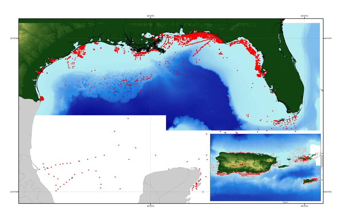
The facies data layer (_FAC.txt) is a point coverage of known sediment samplings, inspections, and probings from the usSEABED data collection and integrated using the software system dbSEABED. The facies data layer (_FAC.txt)represents concatenated information about components (minerals and rock type), genesis (igneous, metamorphic, carbonate, terrigenous), and other appropriate groupings of information about the seafloor. The facies data are parsed from written descriptions from cores, grabs, photographs, and videos, and may apply only to a subsample as denoted by the Top, Bottom, and SamplePhase fields. Lack of values in a defined facies field does not necessarily imply lack of the components defining that field, but may imply a lack of data for that field.
Purpose:
The Facies layer can be used to investigate the known information about a particular area of the seafloor. These data are intended for science researchers, policy makers, students, and the general public. The data can be used with geographic information systems (GIS) software to display geologic and oceanographic information.
Supplemental_Information:
This layer can be used in a relational data base, using the DataSetKey to link to the GMX_SRC.txt file for brief metadata information and to formal metadata written on each source, and to the other data files of usSEABED using the SiteKey or SampleKey as relational links.
Time_Period_of_Content:
Time_Period_Information:
Single_Date/Time:
Calendar_Date: 2006
Currentness_Reference: publication date
Status:
Progress: In work
Maintenance_and_Update_Frequency: As needed
Spatial_Domain:
Bounding_Coordinates:
West_Bounding_Coordinate: -100.000000
East_Bounding_Coordinate: -64.000000
North_Bounding_Coordinate: 32.000000
South_Bounding_Coordinate: 17.000000
Keywords:
Theme:
Theme_Keyword_Thesaurus: USGS Metadata Identifier
Theme_Keyword: USGS:14af0265-273c-4c95-a39b-c42554405186
Theme:
Theme_Keyword_Thesaurus: None
Theme_Keyword: marine
Theme_Keyword: sediment
Theme_Keyword: seafloor
Theme_Keyword: seabed
Theme_Keyword: descriptions
Theme_Keyword: analyses
Theme_Keyword: usSEABED
Theme_Keyword: dbSEABED
Theme_Keyword: components
Theme_Keyword: features
Theme_Keyword: genesis
Theme_Keyword: facies
Theme_Keyword: U.S. Geological Survey
Theme_Keyword: Coastal and Marine Geology Program
Theme_Keyword: Woods Hole Science Center
Theme_Keyword: Pacific Science Center
Theme_Keyword: Marine Aggregates Resources and Processes Project
Theme_Keyword: Benthic Habitats (Pacific) Project
Theme_Keyword: University of Colorado
Theme_Keyword: Institute of Arctic and Alpine Research
Theme_Keyword: USGS
Theme_Keyword: CMGP
Theme_Keyword: WHSC
Theme_Keyword: PSC
Theme_Keyword: UC
Theme_Keyword: INSTAAR
Theme:
Theme_Keyword_Thesaurus: ISO 19115 Topic Category
Theme_Keyword: oceans
Theme_Keyword: location
Theme_Keyword: geoscientificInformation
Theme:
Theme_Keyword_Thesaurus: Coastal and Marine Ecological Classification Standard (CMECS)
Theme_Keyword: Marine Nearshore
Theme_Keyword: Marine Offshore
Theme_Keyword: Estuarine Coastal
Theme_Keyword: Continental/Island Shelf
Theme_Keyword: Continental/Island Slope
Theme_Keyword: Unconsolidated Mineral Substrate
Theme:
Theme_Keyword_Thesaurus: Data Categories for Marine Planning
Theme_Keyword: distributions
Theme_Keyword: sand resources
Theme_Keyword: substrate
Theme:
Theme_Keyword_Thesaurus: Marine Realms Information Bank (MRIB) Keywords
Theme_Keyword: seabed
Theme_Keyword: sediment resources
Theme_Keyword: sand deposit
Theme:
Theme_Keyword_Thesaurus: USGS Thesaurus
Theme_Keyword: sea-floor characteristics
Theme_Keyword: nonmetallic mineral resources
Theme_Keyword: gravel deposits
Theme_Keyword: sand deposits
Place:
Place_Keyword_Thesaurus: Geographic Names Information System
Place_Keyword: Gulf of Mexico
Place_Keyword: U.S. Gulf Coast
Place_Keyword: Puerto Rico
Place_Keyword: U.S. Virgin Islands
Place_Keyword: United States
Place_Keyword: North America
Place_Keyword: Caribbean Sea
Place:
Place_Keyword_Thesaurus: Coastal and Marine Ecological Classification Standard (CMECS)
Place_Keyword: Floridian Ecoregion
Place_Keyword: Northern Gulf of Mexico Ecoregion
Place_Keyword: Greater Antilles Ecoregion
Stratum:
Stratum_Keyword_Thesaurus: Coastal and Marine Ecological Classification Standard (CMECS)
Stratum_Keyword: Substrate
Access_Constraints: None
Use_Constraints:
Public domain data from the U.S. Government are freely redistributable with the proper metadata and source attribution. Please recognize the U.S. Geological Survey (USGS) as the source of this information.
Point_of_Contact:
Contact_Information:
Contact_Person_Primary:
Contact_Person: Jane A. Reid
Contact_Organization: U.S. Geological Survey
Contact_Position: Geologist
Contact_Address:
Address_Type: mailing and physical address
Address: Pacific Science Center
Address: 400 Natural Bridges Drive
City: Santa Cruz
State_or_Province: CA
Postal_Code: 95060
Country: USA
Contact_Voice_Telephone: 831-427-4727
Contact_Electronic_Mail_Address: jareid@usgs.gov
Contact_Instructions: email preferred
Browse_Graphic:
Browse_Graphic_File_Name: https://pubs.usgs.gov/ds/2006/146/data/gmx_fac.jpg
Browse_Graphic_File_Description: Image map showing extent of data layer coverage
Browse_Graphic_File_Type: JPEG
Data_Set_Credit:
We thank the following interns for their assistance in data entry, coding, and data testing: Viness Ubert, Emma Mitchell, Emily Denham, Shea Quinn and Ariadne Prior-Grosch.
Native_Data_Set_Environment:
Tkme: Another editor for formal metadata by Peter N. Schweitzer (U.S. Geological Survey, Reston, VA 22092), version 2.9.13, Microsoft Windows Version 5.1; Microsoft Word 2000 9.0
Data_Quality_Information:
Attribute_Accuracy:
Attribute_Accuracy_Report:
Accuracy of each attribute is dependent on the accuracy of the original source description and the values calculated by the mining software, dbSEABED. Values are based on filters using fuzzy set theory and represent a measure of truth about the attribute.
Logical_Consistency_Report:
Data in the usSEABED data collection are based on the observations and analyses of others, filtered through a unifying and mining software. Each source report varies in type of information/data recorded and format. Only those observations that are recorded can be filtered and mined; only presence (not absences) of information can be noted.
Completeness_Report:
Additional useable data may exist in this area; the authors appreciate any information and leads.
Positional_Accuracy:
Horizontal_Positional_Accuracy:
Horizontal_Positional_Accuracy_Report:
Locational accuracy is dependent on both the accuracy of the navigational technique and the level of detail about the location as recorded in the individual data sources, and may vary widely (ie.g., from 0.005 km (differential GPS) in the more recent surveys to greater than 2 km based on radar, Loran, or dead reckoning in the older surveys. Users of the data should note the metadata written about the original sources and use their own criteria for assessing the accuracy of the locations.
Vertical_Positional_Accuracy:
Vertical_Positional_Accuracy_Report:
Depth determinations, both water depth and subsample depth, are dependent on the accuracy of the depth determination technique and the level of detail noted in the original source. Users of the data should note the metadata written about the original sources and use their own criteria for assessing the accuracy of the locations.
Lineage:
Source_Information:
Source_Citation:
Citation_Information:
Originator: Various
Publication_Date: unknown
Title:
See separate listing, GMX_SRC.txt, and links provided therein, within this publication for the specific sources and associated metadata.
Geospatial_Data_Presentation_Form: Hard copy documents and digital files
Publication_Information:
Publication_Place: Various
Publisher: Various
Other_Citation_Details:
X number of sources, both published and unpublished, are used as the sources of information for usSEABED. Metadata for each source is linked through the usSEABED source file (GMX_SRC.txt). Sources include the U.S. Geological Survey (USGS), the U.S. Army Corps of Engineers (USACE), Minerals Management Service (MMS), National Oceanic and Atmospheric Administration (NOAA), Virginia Institute of Marine Science (VIMS), the Maryland and New Jersey State Geological Surveys (MGS, NJGS), NOAA's National Geophysical Data Center (NGDC), the Smithsonian Institution, and others.
Type_of_Source_Media: Hard copy and digital
Source_Time_Period_of_Content:
Time_Period_Information:
Range_of_Dates/Times:
Beginning_Date: 1840
Ending_Date: 2003
Source_Currentness_Reference: Source publication date or date of collection
Source_Citation_Abbreviation: Varies with source
Source_Contribution:
Point locations, descriptions, and various analytical data (textural, granulometric, geochemical, geophysical, acoustic) on sediments, rock exposure, and benthos. Varies with source.
Process_Step:
Process_Description:
Source data may be digitized as necessary (typed or scanned in), with a visual inspection of digitized data to the source report and corrections as necessary, and are tested for completeness in Microsoft Excel as appropriate. Other digital data may be decoded using source-specific programs, downloaded via the web, or sent directly to the USGS or University of Colorado via email. Data are formatted into the dbSEABED Data Entry template (db9_DataEntry.xls, version 08/07/2004) by hand, and tested using the dbSEABED relational database program (RDBi, version 01/05/2006) for correctness of formatting. Data are compiled into source data resource files (DRF) and processed through the dbSEABED data mining program (MNEt, version 04/07/2006) program, using the dbSEABED thesaurus (db9_dct.rtf, version 04/07/2006) and facies set up file for U.S. waters (db9_FAC.txt, version 04/07/2006). Data are iteratively reprocessed and corrected until noted errors are fixed, as recorded by the _RBDS.2fx and _MNE.DGN files. Data are exercised in a GIS for location tests and useability. Please review the Larger_Work_Citation for information about how the data are compiled, integrated, and processed in the usSEABED database.
Source_Used_Citation_Abbreviation: GMX_FAC.txt
Process_Date: 2006
Source_Produced_Citation_Abbreviation: gmx_fac.dbf
Source_Produced_Citation_Abbreviation: gmx_fac.shp
Source_Produced_Citation_Abbreviation: gmx_fac.shx
Process_Contact:
Contact_Information:
Contact_Organization_Primary:
Contact_Organization: U.S. Geological Survey
Contact_Person: Brian J. Buczkowski
Contact_Position: Core Curator and Data Management Specialist
Contact_Address:
Address_Type: Mail and Physical
Address: USGS Woods Hole Science Centers
Address: 384 Woods Hole Road
City: Woods Hole
State_or_Province: MA
Postal_Code: 02543-1598
Contact_Voice_Telephone: (508) 548-8700 x2361
Contact_Electronic_Mail_Address: bbuczkowski@usgs.gov
Contact_Instructions: email preferred
Process_Step:
Process_Description:
Edits to the metadata were made to fix any errors that MP v 2.9.36 flagged. This is necessary to enable the metadata to be successfully harvested for various data catalogs. In some cases, this meant adding text "Information unavailable" or "Information unavailable from original metadata" for those required fields that were left blank. Other minor edits were probably performed (title, publisher, publication place, etc.). In attributes with range domains, a value of 9999 was entered in the minimum and maximum values to indicate the original metadata did not contain the required information. Minor fixes to the attribute format for some attributes were needed. Attempted to modify http to https where appropriate. The metadata date (but not the metadata creator) was edited to reflect the date of these changes. The metadata available from a harvester may supersede metadata bundled within a download file. Compare the metadata dates to determine which metadata file is most recent.
Process_Date: 20170126
Process_Contact:
Contact_Information:
Contact_Organization_Primary:
Contact_Organization: U.S. Geological Survey
Contact_Person: VeeAnn A. Cross
Contact_Position: Marine Geologist
Contact_Address:
Address_Type: Mailing and Physical
Address: 384 Woods Hole Road
City: Woods Hole
State_or_Province: MA
Postal_Code: 02543-1598
Contact_Voice_Telephone: 508-548-8700 x2251
Contact_Facsimile_Telephone: 508-457-2310
Contact_Electronic_Mail_Address: vatnipp@usgs.gov
Process_Step:
Process_Description:
Keywords added to metadata support discovery in the USGS Coastal and Marine Geology Data Catalog.
Process_Date: 20180426
Process_Contact:
Contact_Information:
Contact_Organization_Primary:
Contact_Organization: U.S. Geological Survey
Contact_Person: Alan O. Allwardt
Contact_Position: Contractor -- Information Specialist
Contact_Address:
Address_Type: mailing and physical address
Address: 2885 Mission Street
City: Santa Cruz
State_or_Province: CA
Postal_Code: 95060
Contact_Voice_Telephone: 831-460-7551
Contact_Facsimile_Telephone: 831-427-4748
Contact_Electronic_Mail_Address: aallwardt@usgs.gov
Process_Step:
Process_Description: Crossref DOI link was added as the first link in the metadata.
Process_Date: 20191115
Process_Contact:
Contact_Information:
Contact_Organization_Primary:
Contact_Organization: U.S. Geological Survey
Contact_Person: VeeAnn A. Cross
Contact_Position: Marine Geologist
Contact_Address:
Address_Type: Mailing and Physical
Address: 384 Woods Hole Road
City: Woods Hole
State_or_Province: MA
Postal_Code: 02543-1598
Contact_Voice_Telephone: 508-548-8700 x2251
Contact_Facsimile_Telephone: 508-457-2310
Contact_Electronic_Mail_Address: vatnipp@usgs.gov
Process_Step:
Process_Description:
Added keywords section with USGS persistent identifier as theme keyword.
Process_Date: 20200908
Process_Contact:
Contact_Information:
Contact_Organization_Primary:
Contact_Organization: U.S. Geological Survey
Contact_Person: VeeAnn A. Cross
Contact_Position: Marine Geologist
Contact_Address:
Address_Type: Mailing and Physical
Address: 384 Woods Hole Road
City: Woods Hole
State_or_Province: MA
Postal_Code: 02543-1598
Contact_Voice_Telephone: 508-548-8700 x2251
Contact_Facsimile_Telephone: 508-457-2310
Contact_Electronic_Mail_Address: vatnipp@usgs.gov
Spatial_Data_Organization_Information:
Direct_Spatial_Reference_Method: Vector
Point_and_Vector_Object_Information:
SDTS_Terms_Description:
SDTS_Point_and_Vector_Object_Type: Point
Point_and_Vector_Object_Count: 6856
Spatial_Reference_Information:
Horizontal_Coordinate_System_Definition:
Geographic:
Latitude_Resolution: 0.00001
Longitude_Resolution: 0.00001
Geographic_Coordinate_Units: Decimal degrees
Geodetic_Model:
Horizontal_Datum_Name: North American Datum of 1927
Ellipsoid_Name: Clarke 1866
Semi-major_Axis: 6378206.400000
Denominator_of_Flattening_Ratio: 294.978698
Entity_and_Attribute_Information:
Detailed_Description:
Entity_Type:
Entity_Type_Label: gmx_fac.dbf
Entity_Type_Definition: Shapefile Attribute Table
Entity_Type_Definition_Source: ESRI
Attribute:
Attribute_Label: Shape
Attribute_Definition: Feature geometry.
Attribute_Definition_Source: ESRI
Attribute_Domain_Values:
Unrepresentable_Domain: Coordinates defining the features.
Attribute:
Attribute_Label: FID
Attribute_Definition: Internal feature number.
Attribute_Definition_Source: ESRI
Attribute_Domain_Values:
Unrepresentable_Domain:
Sequential unique whole numbers that are automatically generated.
Attribute:
Attribute_Label: LATITUDE
Attribute_Definition: Latitude coordinate of sample location
Attribute_Definition_Source: USGS
Attribute_Domain_Values:
Range_Domain:
Range_Domain_Minimum: 17.45500
Range_Domain_Maximum: 30.50167
Attribute_Units_of_Measure: decimal degrees
Attribute_Measurement_Resolution: .00001
Attribute:
Attribute_Label: LONGITUDE
Attribute_Definition: Longitude coordinate of sample location
Attribute_Definition_Source: USGS
Attribute_Domain_Values:
Range_Domain:
Range_Domain_Minimum: -97.94945
Range_Domain_Maximum: -64.37389
Attribute_Units_of_Measure: decimal degrees
Attribute_Measurement_Resolution: .00001
Attribute:
Attribute_Label: WATERDEPTH
Attribute_Definition: Water depth; Not always tidally correct.
Attribute_Definition_Source: USGS
Attribute_Domain_Values:
Range_Domain:
Range_Domain_Minimum: 0
Range_Domain_Maximum: 6400
Attribute_Units_of_Measure: meters
Attribute_Measurement_Resolution: 1
Attribute:
Attribute_Label: SAMPLETOP
Attribute_Definition:
Measured subbottom depth information for each point sample (top)
Attribute_Definition_Source: USGS
Attribute_Domain_Values:
Range_Domain:
Range_Domain_Minimum: 0.00
Range_Domain_Maximum: 37.80
Attribute_Units_of_Measure: meters
Attribute_Measurement_Resolution: .01
Attribute:
Attribute_Label: SAMPLEBASE
Attribute_Definition:
Sample base below seabed surface; Sample bottom as noted in source report.
Attribute_Definition_Source: USGS
Attribute_Domain_Values:
Range_Domain:
Range_Domain_Minimum: 0.00
Range_Domain_Maximum: 37.80
Attribute_Units_of_Measure: meters
Attribute_Measurement_Resolution: 0.01
Attribute:
Attribute_Label: SITE
Attribute_Definition: Information unavailable from original metadata.
Attribute_Definition_Source: USGS
Attribute_Domain_Values:
Unrepresentable_Domain: Character String
Attribute:
Attribute_Label: DATASETKEY
Attribute_Definition:
Data set key (relational link); Unique sequential numeric key to SRC file
Attribute_Definition_Source: USGS
Attribute_Domain_Values:
Range_Domain:
Range_Domain_Minimum: 1
Range_Domain_Maximum: 542
Attribute_Units_of_Measure: integer count
Attribute_Measurement_Resolution: 1
Attribute:
Attribute_Label: SITEKEY
Attribute_Definition:
Site key (relational link); Unique sequential numeric key to information about the same site in other usSEABED data files
Attribute_Definition_Source: USGS
Attribute_Domain_Values:
Range_Domain:
Range_Domain_Minimum: 13
Range_Domain_Maximum: 221248
Attribute_Units_of_Measure: integer count
Attribute_Measurement_Resolution: 1
Attribute:
Attribute_Label: SAMPLEKEY
Attribute_Definition:
Sample key (relational link); Unique sequential numeric key to information about the same sample or subsample in other usSEABED data files
Attribute_Definition_Source: USGS
Attribute_Domain_Values:
Range_Domain:
Range_Domain_Minimum: 73
Range_Domain_Maximum: 259197
Attribute_Units_of_Measure: integer count
Attribute_Measurement_Resolution: 1
Attribute:
Attribute_Label: SAMPLER
Attribute_Definition: Type of sampling device ss given in source report
Attribute_Definition_Source: USGS
Attribute_Domain_Values:
Unrepresentable_Domain: Character String
Attribute:
Attribute_Label: DATATYPE
Attribute_Definition: Data types
Attribute_Definition_Source:
dbSEABED thesaurus; see table D in the data publication (Larger_Work_Citation) for list of triggering major synonyms
Attribute_Domain_Values:
Unrepresentable_Domain: Character String
Attribute:
Attribute_Label: TERRIGENOU
Attribute_Definition: Those samples with a terrigenous component
Attribute_Definition_Source: USGS
Attribute_Domain_Values:
Range_Domain:
Range_Domain_Minimum: 0
Range_Domain_Maximum: 100
Attribute_Units_of_Measure: percent
Attribute_Measurement_Resolution: 1
Attribute:
Attribute_Label: VOLCANIC
Attribute_Definition:
Those samples with a volcanic component; Result of filters based on fuzzy set theory determining degree of membership (0-100) for samples that include those terms which denote a specific volcanic rock (volrck and vol_rck), basalt, pumice, volcanic glass, or volcanic sediment; see table D in the data publication (Larger_Work_Citation) for list of trigger terms under each component mentioned.
Attribute_Definition_Source: USGS
Attribute_Domain_Values:
Range_Domain:
Range_Domain_Minimum: 9999
Range_Domain_Maximum: 9999
Attribute_Units_of_Measure: percent
Attribute_Measurement_Resolution: 1
Attribute:
Attribute_Label: CALCPELAG
Attribute_Definition: calcareous pelagics
Attribute_Definition_Source: USGS
Attribute_Domain_Values:
Range_Domain:
Range_Domain_Minimum: 0
Range_Domain_Maximum: 100
Attribute_Units_of_Measure: percent
Attribute_Measurement_Resolution: 1
Attribute:
Attribute_Label: SILCPELAG
Attribute_Definition: Silceous pelagic fauna/flora
Attribute_Definition_Source: USGS
Attribute_Domain_Values:
Range_Domain:
Range_Domain_Minimum: 9999
Range_Domain_Maximum: 9999
Attribute_Units_of_Measure: percent
Attribute_Measurement_Resolution: 1
Attribute:
Attribute_Label: CARBMUD
Attribute_Definition: Information unavailable from original metadata.
Attribute_Definition_Source: USGS
Attribute_Domain_Values:
Range_Domain:
Range_Domain_Minimum: 9999
Range_Domain_Maximum: 9999
Attribute_Units_of_Measure: percent
Attribute_Measurement_Resolution: 1
Attribute:
Attribute_Label: CARBSAND
Attribute_Definition: Information unavailable from original metadata.
Attribute_Definition_Source: USGS
Attribute_Domain_Values:
Range_Domain:
Range_Domain_Minimum: 9999
Range_Domain_Maximum: 9999
Attribute_Units_of_Measure: percent
Attribute_Measurement_Resolution: 1
Attribute:
Attribute_Label: CALCCRUST_
Attribute_Definition: Information unavailable from original metadata.
Attribute_Definition_Source: USGS
Attribute_Domain_Values:
Range_Domain:
Range_Domain_Minimum: 9999
Range_Domain_Maximum: 9999
Attribute_Units_of_Measure: percent
Attribute_Measurement_Resolution: 1
Attribute:
Attribute_Label: ZCORAL_
Attribute_Definition: Information unavailable from original metadata.
Attribute_Definition_Source: USGS
Attribute_Domain_Values:
Range_Domain:
Range_Domain_Minimum: 0
Range_Domain_Maximum: 100
Attribute_Units_of_Measure: percent
Attribute_Measurement_Resolution: 1
Attribute:
Attribute_Label: SHELL
Attribute_Definition:
Result of filters based on fuzzy set theory determining degree of membership (0-100) for samples that include those terms which denote a specific shell or shell debris component; see table D in the data publication (Larger_Work_Citation) for list of trigger terms under each component mentioned.
Attribute_Definition_Source: USGS
Attribute_Domain_Values:
Range_Domain:
Range_Domain_Minimum: 0
Range_Domain_Maximum: 100
Attribute_Units_of_Measure: percent
Attribute_Measurement_Resolution: 1
Attribute:
Attribute_Label: CORALREEF
Attribute_Definition: Information unavailable from original metadata.
Attribute_Definition_Source: USGS
Attribute_Domain_Values:
Range_Domain:
Range_Domain_Minimum: 9999
Range_Domain_Maximum: 9999
Attribute_Units_of_Measure: percent
Attribute_Measurement_Resolution: 1
Attribute:
Attribute_Label: OOLITE
Attribute_Definition: Information unavailable from original metadata.
Attribute_Definition_Source: USGS
Attribute_Domain_Values:
Range_Domain:
Range_Domain_Minimum: 9999
Range_Domain_Maximum: 9999
Attribute_Units_of_Measure: percent
Attribute_Measurement_Resolution: 1
Attribute:
Attribute_Label: SPONGE
Attribute_Definition: Information unavailable from original metadata.
Attribute_Definition_Source: USGS
Attribute_Domain_Values:
Range_Domain:
Range_Domain_Minimum: 9999
Range_Domain_Maximum: 9999
Attribute_Units_of_Measure: percent
Attribute_Measurement_Resolution: 1
Attribute:
Attribute_Label: BRYOZOAN
Attribute_Definition: Information unavailable from original metadata.
Attribute_Definition_Source: USGS
Attribute_Domain_Values:
Range_Domain:
Range_Domain_Minimum: 9999
Range_Domain_Maximum: 9999
Attribute_Units_of_Measure: percent
Attribute_Measurement_Resolution: 1
Attribute:
Attribute_Label: LARGEFRM
Attribute_Definition: Information unavailable from original metadata.
Attribute_Definition_Source: USGS
Attribute_Domain_Values:
Range_Domain:
Range_Domain_Minimum: 9999
Range_Domain_Maximum: 9999
Attribute_Units_of_Measure: percent
Attribute_Measurement_Resolution: 1
Attribute:
Attribute_Label: RHODOLITH
Attribute_Definition: Information unavailable from original metadata.
Attribute_Definition_Source: USGS
Attribute_Domain_Values:
Range_Domain:
Range_Domain_Minimum: 9999
Range_Domain_Maximum: 9999
Attribute_Units_of_Measure: percent
Attribute_Measurement_Resolution: 1
Attribute:
Attribute_Label: CORALLNALG
Attribute_Definition: Information unavailable from original metadata.
Attribute_Definition_Source: USGS
Attribute_Domain_Values:
Range_Domain:
Range_Domain_Minimum: 9999
Range_Domain_Maximum: 9999
Attribute_Units_of_Measure: percent
Attribute_Measurement_Resolution: 1
Attribute:
Attribute_Label: HALIMEDA
Attribute_Definition: Information unavailable from original metadata.
Attribute_Definition_Source: USGS
Attribute_Domain_Values:
Unrepresentable_Domain: Information unavailable from original metadata.
Attribute:
Attribute_Label: PHOSPHATE
Attribute_Definition: Information unavailable from original metadata.
Attribute_Definition_Source: USGS
Attribute_Domain_Values:
Range_Domain:
Range_Domain_Minimum: 9999
Range_Domain_Maximum: 9999
Attribute_Units_of_Measure: percent
Attribute_Measurement_Resolution: 1
Attribute:
Attribute_Label: MINERALIZE
Attribute_Definition: Information unavailable from original metadata.
Attribute_Definition_Source: USGS
Attribute_Domain_Values:
Range_Domain:
Range_Domain_Minimum: 9999
Range_Domain_Maximum: 9999
Attribute_Units_of_Measure: percent
Attribute_Measurement_Resolution: 1
Attribute:
Attribute_Label: HEAVYMIN
Attribute_Definition: Information unavailable from original metadata.
Attribute_Definition_Source: USGS
Attribute_Domain_Values:
Range_Domain:
Range_Domain_Minimum: 9999
Range_Domain_Maximum: 9999
Attribute_Units_of_Measure: percent
Attribute_Measurement_Resolution: 1
Attribute:
Attribute_Label: GLAUC_RELI
Attribute_Definition: Information unavailable from original metadata.
Attribute_Definition_Source: USGS
Attribute_Domain_Values:
Range_Domain:
Range_Domain_Minimum: 9999
Range_Domain_Maximum: 9999
Attribute_Units_of_Measure: percent
Attribute_Measurement_Resolution: 1
Attribute:
Attribute_Label: SEAGRASS
Attribute_Definition: Information unavailable from original metadata.
Attribute_Definition_Source: USGS
Attribute_Domain_Values:
Range_Domain:
Range_Domain_Minimum: 9999
Range_Domain_Maximum: 9999
Attribute_Units_of_Measure: percent
Attribute_Measurement_Resolution: 1
Attribute:
Attribute_Label: PLANTS
Attribute_Definition: Information unavailable from original metadata.
Attribute_Definition_Source: USGS
Attribute_Domain_Values:
Range_Domain:
Range_Domain_Minimum: 0
Range_Domain_Maximum: 100
Attribute_Units_of_Measure: percent
Attribute_Measurement_Resolution: 1
Attribute:
Attribute_Label: MNNODULE
Attribute_Definition: Information unavailable from original metadata.
Attribute_Definition_Source: USGS
Attribute_Domain_Values:
Range_Domain:
Range_Domain_Minimum: 9999
Range_Domain_Maximum: 9999
Attribute_Units_of_Measure: percent
Attribute_Measurement_Resolution: 1
Attribute:
Attribute_Label: SAMPLEPHAS
Attribute_Definition: Information unavailable from original metadata.
Attribute_Definition_Source: USGS
Attribute_Domain_Values:
Unrepresentable_Domain: Character String
Overview_Description:
Entity_and_Attribute_Overview:
Values of -99 for any field are indications that there was no data available.
Entity_and_Attribute_Detail_Citation: U.S. Geological Survey
Distribution_Information:
Distributor:
Contact_Information:
Contact_Organization_Primary:
Contact_Organization: U.S. Geological Survey
Contact_Person: Brian J. Buczkowski
Contact_Position: Core Curator and Data Management Specialist
Contact_Address:
Address_Type: mailing and physical address
Address: 384 Woods Hole Road
City: Woods Hole
State_or_Province: MA
Postal_Code: 02543-1598
Country: USA
Contact_Voice_Telephone: (508) 548-8700 x2361
Contact_Facsimile_Telephone: (508) 457-2310
Contact_Electronic_Mail_Address: bbuczkowski@usgs.gov
Contact_Instructions: email preferred
Resource_Description: Downloadable Data
Distribution_Liability:
Although this data set has been used by the U.S. Geological Survey (USGS), no warranty, expressed or implied, is made by the USGS as to the accuracy of the data and/or related materials. The act of distribution shall not constitute any such warranty, and no responsibility is assumed by the USGS in the use of these data or related materials. Trade, firm, or product names and other references to non-USGS products and services are provided for information only and do not constitute endorsement or warranty, express or implied, by the USGS, USDOI, or U.S. Government, as to their suitability, content, usefulness, functioning, completeness, or accuracy.
Standard_Order_Process:
Digital_Form:
Digital_Transfer_Information:
Format_Name: ASCII text
Format_Information_Content:
Text file containing data input to usSEABED. Fields are comma separated values. First record of file contains field names.
File_Decompression_Technique: no compression applied
Transfer_Size: 2.17
Digital_Transfer_Option:
Online_Option:
Computer_Contact_Information: Access_Instructions: Data may be downloaded via the World Wide Web (WWW).
Offline_Option:
Offline_Media: CD-ROM
Recording_Capacity:
Recording_Density: 650
Recording_Density_Units: Mbytes
Recording_Format: ISO and HFS
Digital_Form:
Digital_Transfer_Information:
Format_Name: SHP
Format_Version_Number: 3.3
Format_Specification: ESRI point shapefile
Format_Information_Content:
The SHP file contains the geospatial data. The SHX file contains the index of the geospatial data. The DBF file contains the attribute data in dBASE format. The PRJ file contains the coordinate system information (optional). The AVL file contains the legend information (optional). The SBN and SBX files contain the spatial index of the geospatial data (optional). The XML file contains the metadata describing the data set <data set name>.shp.xml. An ASCII version of the metadata file. A browse graphic showing the data layer coverage and extent (optional).
File_Decompression_Technique: winzip
Digital_Transfer_Option:
Online_Option:
Computer_Contact_Information: Access_Instructions: Data may be downloaded via the World Wide Web (WWW).
Offline_Option:
Offline_Media: CD-ROM
Recording_Capacity:
Recording_Density: 650
Recording_Density_Units: Mbytes
Recording_Format: ISO and HFS
Fees: None
Technical_Prerequisites:
These data are available in Environmental Systems Research Institute (ESRI) shapefile format. The user must have ArcGIS or ArcView 3.0 or greater software to read and process the data file. In lieu of ArcView or ArcGIS, the user may utilize another GIS application package capable of importing the data. A free data viewer, arcexplorer, capable of displaying the data is available from ESRI at www.esri.com.
Metadata_Reference_Information:
Metadata_Date: 20240318
Metadata_Contact:
Contact_Information:
Contact_Person_Primary:
Contact_Person: Jane A. Reid
Contact_Organization: U.S. Geological Survey
Contact_Position: Geologist
Contact_Address:
Address_Type: Mail and physical
Address: Pacific Science Center
Address: 400 Natural Bridges Drive
City: Santa Cruz
State_or_Province: CA
Postal_Code: 95060
Country: USA
Contact_Voice_Telephone: 831-427-4727
Contact_Electronic_Mail_Address: whsc_data_contact@usgs.gov
Contact_Instructions:
The metadata contact email address is a generic address in the event the person is no longer with USGS. (updated on 20240318)
Metadata_Standard_Name: FGDC Content Standards for Digital Geospatial Metadata
Metadata_Standard_Version: FGDC-STD-001-1998
Metadata_Time_Convention: local time
Metadata_Access_Constraints: None
Metadata_Use_Constraints: None

This page is <https://cmgds.marine.usgs.gov/catalog/whcmsc/data_series/DS-146/gmx_fac.shp.html>
Generated by mp version 2.9.51 on Mon Mar 25 16:05:16 2024