Online Links:
Online Links:
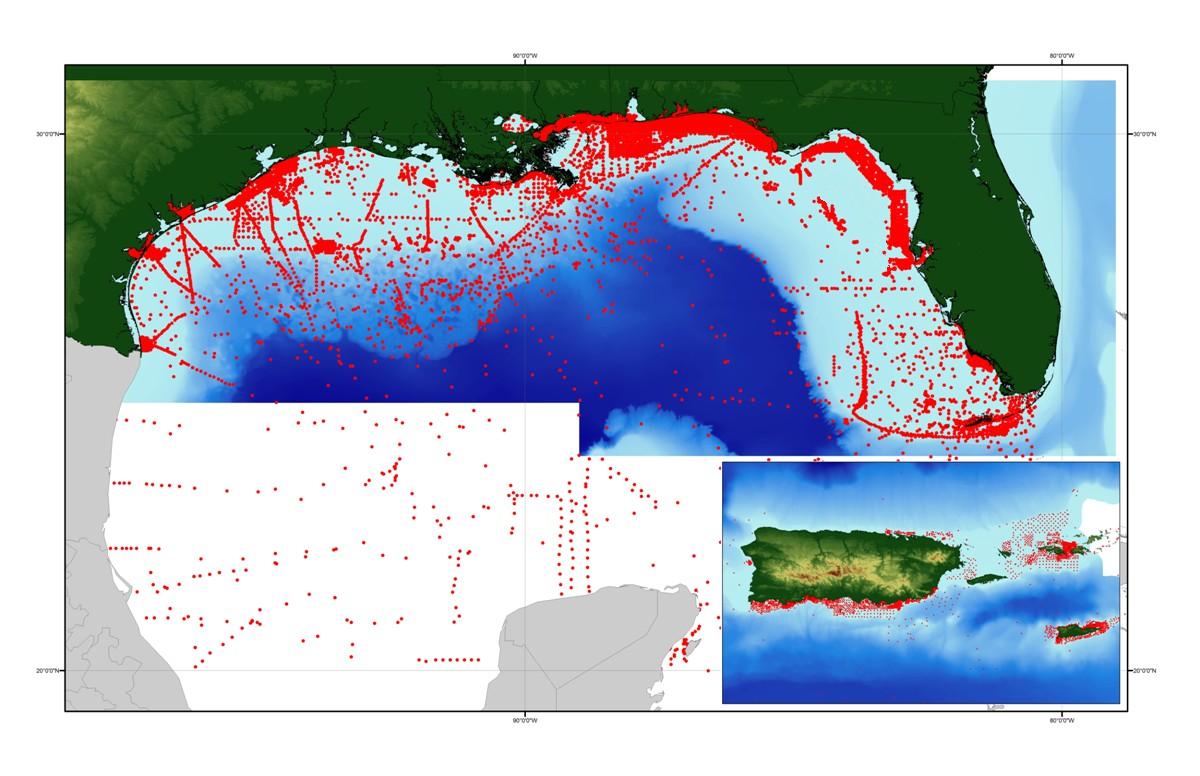
| Range of values | |
|---|---|
| Minimum: | 17.0667 |
| Maximum: | 30.64300 |
| Units: | decimal degrees |
| Resolution: | .00001 |
| Range of values | |
|---|---|
| Minimum: | -97.94945 |
| Maximum: | -86.86653 |
| Units: | decimal degrees |
| Resolution: | .00001 |
| Range of values | |
|---|---|
| Minimum: | 0 |
| Maximum: | 6770 |
| Units: | meters |
| Resolution: | 1 |
| Range of values | |
|---|---|
| Minimum: | 0 |
| Maximum: | 470 |
| Units: | meters |
| Resolution: | 1 |
| Range of values | |
|---|---|
| Minimum: | 0 |
| Maximum: | 50.29 |
| Units: | meters |
| Resolution: | 0.01 |
| Range of values | |
|---|---|
| Minimum: | 1 |
| Maximum: | 542 |
| Units: | integer count |
| Resolution: | 1 |
| Range of values | |
|---|---|
| Minimum: | 1 |
| Maximum: | 221248 |
| Units: | integer count |
| Resolution: | 1 |
| Range of values | |
|---|---|
| Minimum: | 1 |
| Maximum: | 259197 |
| Units: | integer count |
| Resolution: | 1 |
| Value | Definition |
|---|---|
| ACU | Acoustic Properties |
| CMP | Sediment Composition |
| COL | Color |
| GTC | Geotechnical Properties |
| GRZ | Grain Size |
| TXR | Texture |
| TXG | Texture (Graphic) |
| LTH | Lithology |
| Range of values | |
|---|---|
| Minimum: | 0 |
| Maximum: | 100 |
| Units: | percent |
| Resolution: | 1 |
| Range of values | |
|---|---|
| Minimum: | 0 |
| Maximum: | 100 |
| Units: | percent |
| Resolution: | 1 |
| Range of values | |
|---|---|
| Minimum: | 0 |
| Maximum: | 100 |
| Units: | percent |
| Resolution: | 1 |
| Range of values | |
|---|---|
| Minimum: | 0 |
| Maximum: | 100 |
| Units: | percent |
| Resolution: | 1 |
| Range of values | |
|---|---|
| Minimum: | -7.3 |
| Maximum: | 12 |
| Units: | phi |
| Resolution: | 0.1 |
| Range of values | |
|---|---|
| Minimum: | 0 |
| Maximum: | 6 |
| Units: | phi |
| Resolution: | 0.1 |
| Range of values | |
|---|---|
| Minimum: | 9999 |
| Maximum: | 9999 |
| Units: | kPa |
| Range of values | |
|---|---|
| Minimum: | 9999 |
| Maximum: | 9999 |
| Units: | Output as a word-based description that may involve numerics. This field will need to be selected against when GIS mappings of the bulk sedient characters are being mapped. Only blank entries should be included in such a mapping. |
| Value | Definition |
|---|---|
| -99 | no data |
| Value | Definition |
|---|---|
| -99 | no data |
| Range of values | |
|---|---|
| Minimum: | 0 |
| Maximum: | 100 |
| Units: | percent |
| Value | Definition |
|---|---|
| -99 | no data |
| Range of values | |
|---|---|
| Minimum: | 9999 |
| Maximum: | 9999 |
| Units: | percent |
| Range of values | |
|---|---|
| Minimum: | 9999 |
| Maximum: | 9999 |
| Units: | meters/second |
| Range of values | |
|---|---|
| Minimum: | 9999 |
| Maximum: | 9999 |
| Units: | values expressed as (rounded) integer log2 of V and H in cm |
| Value | Definition |
|---|---|
| GRAVEL | sediment whose main phase is >2 mm ( ususlly >50%) |
| GRAVELLY SEDIMENT | sediment with significant amounts of gravel (>10%, but <50%) |
| SAND | sediment whose main phase is <2 mm, but >.062 mm |
| SEDIMENT | Information unavailable from original metadata. |
| SOLID | Information unavailable from original metadata. |
| Access_Constraints | None |
|---|---|
| Use_Constraints | Public domain data from the U.S. Government are freely redistributable with proper metadata and source attribution. Please recognize the U.S. Geological Survey (USGS) as the source of this information. |
| Data format: | Text file containing data input to usSEABED. Fields are comma separated values. First record of file contains field names. in format ASCII Size: 13.3 |
|---|---|
| Network links: |
https://pubs.usgs.gov/ds/2006/146/data/gmx_prs.txt http://pubs.usgs.gov/ds/2006/146/htmldocs/data_cata.htm |
| Media you can order: | CD-ROM (Density 650 Mbytes) (format ISO and HFS) |
| Data format: | The SHP file contains the geospatial data. The SHX file contains the index of the geospatial data. The DBF file contains the attribute data in dBASE format. The PRJ file contains the coordinate system information (optional). The AVL file contains the legend information (optional). The SBN and SBX files contain the spatial index of the geospatial data (optional). The XML file contains the metadata describing the data set <data set name>.shp.xml. An ASCII version of the metadata file. A browse graphic showing the data layer coverage and extent (optional). in format SHP (version Information unavailable from original metadata.) ESRI point shapefile |
|---|---|
| Network links: |
https://pubs.usgs.gov/ds/2006/146/data/gmx_prs.zip https://pubs.usgs.gov/ds/2006/146/htmldocs/data_cata.htm |
| Media you can order: | CD-ROM (Density 650 Mbytes) (format ISO and HFS) |