Processed continuous resistivity profiling data collected in Greenwich Bay, Rhode Island, on May 14, 2009, on U.S. Geological Survey Field Activity 2009-021-FA

Metadata also available as - [Outline] - [Parseable text] - [XML]

Frequently anticipated questions:


What does this data set describe?

Title:
Processed continuous resistivity profiling data collected in Greenwich Bay, Rhode Island, on May 14, 2009, on U.S. Geological Survey Field Activity 2009-021-FA
Abstract:
As part of a larger investigation to understand groundwater-surface water interactions in Greenwich Bay, Rhode Island, a geophysical survey was conducted from a small research boat on 14-15 May 2009. The specific research objective was to gain an improved understanding of the role of direct groundwater discharge in delivery of excess nitrogen to the bay, which may have contributed to the development of low-oxygen conditions in waters of the bay and associated fish kills. Data collected in this survey included digital navigation information, continuous resistivity profiling (CRP) data, and point salinity measurements. The CRP method is a survey and data processing approach that is sensitive to differences in electrical properties of surface water and underlying porewater in sediments that have contrasting salinities. During the survey, Greenwich Bay salinity was approximately 27 ppm, so surface water would be expected to have low electrical resistivity (high conductivity), and any areas of active groundwater discharge from less salty aquifer sources would yield relatively higher resistivity values. This survey is identified as field activity 09021 (also referenced as 2009-021-FA) by the U.S. Geological Survey, Woods Hole, Massachusetts, and additional information is available from: https://cmgds.marine.usgs.gov/fan_info.php?fan=2009-021-FA.
  1. How might this data set be cited?
    Bratton, John F., and Cross, VeeAnn A., 2018, Processed continuous resistivity profiling data collected in Greenwich Bay, Rhode Island, on May 14, 2009, on U.S. Geological Survey Field Activity 2009-021-FA: data release DOI:10.5066/F7DR2TSX, U.S. Geological Survey, Coastal and Marine Geology Program, Woods Hole Coastal and Marine Science Center, Woods Hole, MA.

    Online Links:

    This is part of the following larger work.

    Bratton, John F., and Cross, VeeAnn A., 2018, Continuous Resistivity Profiling Data and Associated Data from Greenwich Bay, Rhode Island collected in 2009, U.S. Geological Survey Field Activity 2009-021-FA: data release DOI:10.5066/F7DR2TSX, U.S. Geological Survey, Reston, VA.

    Online Links:

    Other_Citation_Details:
    Suggested citation: Bratton, J.F., and Cross, V.A., 2018, Continuous resistivity profiling data and associated data from Greenwich Bay, Rhode Island collected in 2009, U.S. Geological Survey Field Activity 2009-021-FA: U.S. Geological Survey data release, https://doi.org/10.5066/F7DR2TSX .
  2. What geographic area does the data set cover?
    West_Bounding_Coordinate: -71.452350
    East_Bounding_Coordinate: -71.391017
    North_Bounding_Coordinate: 41.696383
    South_Bounding_Coordinate: 41.651083
  3. What does it look like?
    https://cmgds.marine.usgs.gov/data/field-activity-data/2009-021-FA/data/geophysics/proc_resis/2009-021-FA_may14_browse.jpg (JPEG)
    Browse graphic of a CRP data profile.
  4. Does the data set describe conditions during a particular time period?
    Calendar_Date: 14-May-2009
    Currentness_Reference:
    ground condition
  5. What is the general form of this data set?
    Geospatial_Data_Presentation_Form: digital files
  6. How does the data set represent geographic features?
    1. How are geographic features stored in the data set?
    2. What coordinate system is used to represent geographic features?
      The horizontal datum used is D_WGS_1984.
      The ellipsoid used is WGS_1984.
      The semi-major axis of the ellipsoid used is 6378137.000000.
      The flattening of the ellipsoid used is 1/298.257224.
      Vertical_Coordinate_System_Definition:
      Depth_System_Definition:
      Depth_Datum_Name: Local surface
      Depth_Resolution: 0.1
      Depth_Distance_Units: meters
      Depth_Encoding_Method: Implicit coordinate
  7. How does the data set describe geographic features?

Who produced the data set?

  1. Who are the originators of the data set? (may include formal authors, digital compilers, and editors)
    • John F. Bratton
    • VeeAnn A. Cross
  2. Who also contributed to the data set?
  3. To whom should users address questions about the data?
    U.S. Geological Survey
    Attn: VeeAnn A. Cross
    Marine Geologist
    384 Woods Hole Rd.
    Woods Hole, MA

    (508) 548-8700x2251 (voice)
    (508) 457-2310 (FAX)
    vatnipp@usgs.gov

Why was the data set created?

The purpose of this dataset is to provide the processed continuous resistivity profile data collected on May 14, 2009 in Greenwich Bay, Rhode Island by the AGI SuperSting system.

How was the data set created?

  1. From what previous works were the data drawn?
    Modified Raw CRP data (modified in the sense that the navigation was cleaned up) (source 1 of 1)
    Bratton, John F., 2015, Raw CRP data.

    Type_of_Source_Media: disk
    Source_Contribution:
    The continuous resistivity profile (CRP) system used on this cruise was an AGI SuperSting marine system described at the website: www.agiusa.com/marinesystem.shtml. Two streamer systems were used during this field activity - a 50-m streamer and a 100-m streamer. The 50-m streamer has an 11 electrode array with electrodes spaced 5 meters apart. The 100-m streamer has an 11 electrode array with electrodes spaced 10 meters apart. In both cases the source electrodes are graphite, while the receiver electrodes are stainless steel. A dipole-dipole configuration was used for the data collection in which two fixed current electrodes are assigned with the measurement of voltage potential between electrode pairs in the remaining electrodes. The maximum depth below the water surface the streamer can reach is approximately 1/4 the streamer length. So for the 50-m streamer, maximum depth is about 12.5 meters while the 100-m streamer maximum depth is about 25 meters. Each line of data acquisition records several files. The two files necessary for processing are the *.stg and the *.gps file. The STG file contains the resistivity data, while the GPS file contains the navigation information. The navigation system used in concert with the CRP system is a Lowrance LMS-480M with an LGC-2000 GPS antenna and a 200 kHz fathometer transducer. The antenna and fathometer transducer were mounted on the starboard side of the boat. The streamer tow point was on the port side aft. The layback offset between the navigation antenna and the first electrode was 16.5 meters. This layback offset was not accounted for during data acquisition, so was entered during processing of the data. The approximately 2.5 m lateral offset between the streamer tow point and the navigation antenna is not accounted for. The Lowrance transducer also contains a temperature sensor that records temperature in degrees Celsius. For depth measurements, Lowrance indicates the speed of sound used by the system is 4800 feet/second, but depths are recorded in meters. Both the temperature and depth information are recorded in the logged GPS file. The CRP system images the subsurface electrical properties of an estuarine, riverine or lacustrine environment. Resistivity differences can be attributed to subsurface geology (conductive vs less conductive layers) and hydrogeologic conditions with fresh water exhibiting high resistivity and saline conditions showing low resistivity.
    
    
    These data then were quality checked prior to processing. This process is described in the metadata of the raw data included in this data release.
  2. How were the data generated, processed, and modified?
    Date: 2009 (process 1 of 5)
    After navigation and data assessment, the actual processing of the resisitivity data could start. The resistivity data were merged with the navigation data and linearized using AGI's Marine Log Manager (MLM) software. This used the *.gps and *.stg files or the raw data. (Note that the Marine Log Manager version is different than the software version of the AGISSAdmin software of which it is a part - although shipped together, the software is developed separately). The version of Marine Log Manager used was AGI SSAdmin MLM v 1.3.4.217. The GPS offset was set to 16.5 since the offset between the navigation antenna and the first electrode of the resistivity streamer was not accounted for in an acquisition offset. Lateral offset (2.5 meters) is not accounted for. Due to navigation gaps, Line 18 was split into three parts. The line names are what the * refers to in the source used and source produced citation. This process step and all subsequent process steps were performed by the same person - VeeAnn A. Cross. Person who carried out this activity:
    U.S. Geological Survey
    Attn: VeeAnn A. Cross
    Marine Geologist
    384 Woods Hole Rd.
    Woods Hole, MA

    508-548-8700 x2251 (voice)
    508-457-2310 (FAX)
    vatnipp@usgs.gov
    Data sources used in this process:
    • Modified Raw CRP data
    Data sources produced in this process:
    • *lin.stg
    • *lin.dep
    Date: 2009 (process 2 of 5)
    Each DEP file was checked for anomalous bathymetry values, or duplicated distance along line values, and those lines in the DEP file were deleted. Data sources used in this process:
    • *.dep
    Data sources produced in this process:
    • *.dep
    Date: 2009 (process 3 of 5)
    EarthImager software does not require that a default resistivity value for the water column be supplied in the DEP file. If one is not supplied, then it calculates a value based on the first electrode pair. On this survey, an additional instrument was deployed to measure water temperature and salinity. This instrument was a YSI 30 which measured temperature and salinity values at various locations during the survey. See the YSI metadata available from the larger work citation for details on the processing of the YSI data. The values did not vary a great deal, so an average water resistivity value of 0.296 ohm-m was added to all the DEP files for processing. Data sources used in this process:
    • *.dep
    Data sources produced in this process:
    • *.dep
    Date: 2009 (process 4 of 5)
    EarthImager version 2.2.8 was then used to process the data files. The process settings were set to CRP - Saltwater. The *.ini file accompanying the results contains the parameters used during processing. These parameters include: minimum voltage: 0.02; minimum abs(V/I): 2E-5; max repeat error: 3%; min apparent res: 0.03; max apparent res: 1000; max reciprocal error: 5%; remove negative resistivity, smooth model inversion; finite element method; Cholesky decomposition; Dirichlet boundary condition; thickness incremental factor: 1.1; depth factor: 1.1; max number of CG iterations: 100; stop criteria: number of iterations 8; max RMS 3%; error reduction 5%; L2Norm; CRP processing using a 65% overlap. These INI files can be loaded in EarthImager to help maintain consistent processing parameters for other datasets. When the files are processed, numerous files are generated. Because of the "roll-along" nature of the processing, each line takes several iterations of processing which are then combined into a single output. The output consists of numerous files including JPEG images and text files representing the XYZ position of each resistivity value. Two JPEG images are generated with each process - a long version with the x-axis labeled with latitudes and longitudes and the corresponding short version with the same information. The JPEG files produced use a color scale for the resistivity that is based on the data extent from that particular file. The JPEG images also include a plot of temperature along the line. In addition to the JPEG images, there are text files with the extensions of *.llt, *.xyz and *.utm. The LLT file has four columns of information: longitude in decimal degrees, latitude in decimal degrees, depth in meters, and resistivity value in ohm-m. The XYZ file has three columns of information: distance along line in meters, depth in meters, and resistivity value in ohm-m. There is also a file created with a UTM extension which has the same format as the LLT file except it contains the coordinates in UTM eastings and northings in the zone appropriate for the survey line (software determined). In this case that would be UTM, Zone 19. This file was not checked for accuracy as software versions in the past gave erroneous UTM fixes. An example of the file naming convention is as follows: For input files of L5F1_lin.stg and L5F1_lin_wres.dep the resulting series of output files are: L5F1_lin1_trial1.ini; L5F1_lin_AllInvRes.llt; L5F1_lin_AllInvRes.xyz; L5F1_lin_trial1_InvResLong.jpg; L5F1_lin_trial1_InvResShort.jpg. You can process an individual line as many times as you want and the software places the results in incrementing folder names starting with trial1. Four files were extremely short and therefore no "roll-along" processing was required. These files were L8F1, L10F1, L18F1_part3 and L19F1. In these cases, the JPEG image and the XYZ data have to be saved manually. First, just the inverted resistivity line is displayed using View - Inverted Resistivity Section. Then the image can be saved using File - Save Image. And finally, the XYZ data had to be saved manually using File - Save Data in XYZ format. The XYZ output file extension is DAT instead of XYZ. Although temperature was recorded during acquisition, the JPEG plot does not show the temperature profile in the short data files. Data sources used in this process:
    • *lin.stg
    • *lin_wres.dep
    Data sources produced in this process:
    • *.ini
    • *.llt
    • *.utm
    • *.xyz
    • *.jpg
    Date: 08-Sep-2020 (process 5 of 5)
    Added keywords section with USGS persistent identifier as theme keyword. Person who carried out this activity:
    U.S. Geological Survey
    Attn: VeeAnn A. Cross
    Marine Geologist
    384 Woods Hole Road
    Woods Hole, MA

    508-548-8700 x2251 (voice)
    508-457-2310 (FAX)
    vatnipp@usgs.gov
  3. What similar or related data should the user be aware of?

How reliable are the data; what problems remain in the data set?

  1. How well have the observations been checked?
  2. How accurate are the geographic locations?
    The navigation system used was a Lowrance 480M with an LGC-2000 Global Positioning System (GPS) antenna. The antenna was located 1.5 meters forward of the resistivity streamer tow point and directly above the fathometer transducer. The GPS is assumed to be accurate to within 10 meters.
  3. How accurate are the heights or depths?
    All bathymetry values were acquired by the 200 kHz Lowrance fathometer. The fathometer was mounted on the starboard side of the University of Rhode Island pontoon boat, directly below the GPS antenna. The Lowrance manufacturer indicates the speed of sound used by the system to calculate depth is 4800 feet/second. The depth values are not corrected for the approximately 0.2 m transducer draft. All depth values are assumed to be accurate to within 1 meter.
  4. Where are the gaps in the data? What is missing?
    All data collected on this day are included. There are no lines 1-4, there were battery problems during data collection. Line 18 had to be split into three separate parts to be processed due to gaps in the navigation. Both the original file, as well as the split files, are included in this dataset.
  5. How consistent are the relationships among the observations, including topology?
    Each file was looked at individually, but the files as a collection were handled in the same manner. All files on May 14, 2009 were collected with a 50-m resistivity streamer. The command file (*.cmd) used for data acquisition has a 1 meter electrode spacing. To adjust to the actual 5 meter spacing between electrodes of the 50-m streamer, a scaling factor of 5 was applied during data acquisition. Four files were too short for the "roll-along" process method (L8F1, L10F1, L18F1_part3 and L19F1). In these cases the files were processed the same way, but the output filenames are slightly different and the XYZ and JPEG image of the resulting inverted resistivity are created manually. Process step 4 explains this.

How can someone get a copy of the data set?

Are there legal restrictions on access or use of the data?
Access_Constraints: None.
Use_Constraints:
The public domain data from the U.S. Government are freely redistributable with proper metadata and source attribution. Please recognize the U.S. Geological Survey as the originator of the dataset.
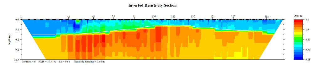
  1. Who distributes the data set? (Distributor 1 of 1)
    VeeAnn A. Cross
    U.S. Geological Survey
    Marine Geologist
    384 Woods Hole Rd.
    Woods Hole, MA

    (508) 548-8700x2251 (voice)
    (508) 457-2310 (FAX)
    vatnipp@usgs.gov
  2. What's the catalog number I need to order this data set? The 2009-021-FA_may14_procres.zip file contains the processed continuous resistivity data from May 14, 2009 (folder 2009-021-FA_may14_procres). This includes the *.ini, *.dat, *.dep, *.llt, *.utm, *.xyz, *.stg, and JPEG images representing the processed data collected on that date. Additionally, the zip file contains a browse graphic (2009-021-FA_may14_browse.jpg) and FGDC CSDGM metadata in the following formats: XML, HTML, and text.
  3. What legal disclaimers am I supposed to read?
    Neither the U.S. government, the Department of the Interior, nor the USGS, nor any of their employees, contractors, or subcontractors, make any warranty, express or implied, nor assume any legal liability or responsibility for the accuracy, completeness, or usefulness of any information, apparatus, product, or process disclosed, nor represent that its use would not infringe on privately owned rights. The act of distribution shall not constitute any such warranty, and no responsibility is assumed by the USGS in the use of these data or related materials. Any use of trade, product, or firm names is for descriptive purposes only and does not imply endorsement by the U.S. Government.
  4. How can I download or order the data?
  5. What hardware or software do I need in order to use the data set?
    The user must have software capable of extracting the data from a zip file, as well as reading and processing the resistivity data, or have the ability to view the JPEG images.

Who wrote the metadata?

Dates:
Last modified: 08-Sep-2020
Metadata author:
VeeAnn A. Cross
U.S. Geological Survey
Marine Geologist
384 Woods Hole Rd.
Woods Hole, MA

(508) 548-8700 x2251 (voice)
(508) 457-2310 (FAX)
vatnipp@usgs.gov
Metadata standard:
FGDC Content Standards for Digital Geospatial Metadata (FGDC-STD-001-1998)

This page is <https://cmgds.marine.usgs.gov/catalog/whcmsc/field_activities/2009_021_fa/2009-021-FA_may14_procresis_meta.faq.html>
Generated by mp version 2.9.50 on Tue Sep 21 18:20:14 2021