Seabed still images in JPEG format and image locations collected on Stellwagen Bank during U.S. Geological Survey field activity 2014-066-FA, aboard the R/V Auk, November 10, 2014

Metadata also available as - [Outline] - [Parseable text] - [XML]

Frequently anticipated questions:


What does this data set describe?

Title:
Seabed still images in JPEG format and image locations collected on Stellwagen Bank during U.S. Geological Survey field activity 2014-066-FA, aboard the R/V Auk, November 10, 2014
Abstract:
This field activity is part of the effort to map geologic substrates of the Stellwagen Bank National Marine Sanctuary region off Boston, Massachusetts. The overall goal is to develop high-resolution (1:25,000) interpretive maps, based on multibeam sonar data and seabed sampling, showing surficial geology and seabed sediment dynamics. This cruise was conducted in collaboration with the Stellwagen Bank National Marine Sanctuary, and the data collected will aid research on the ecology of fish and invertebrate species that inhabit the region. The Sanctuary's research vessel, R/V Auk, visited 44 locations on Stellwagen Bank at which a customized Van Veen grab sampler (SEABOSS) equipped with a video camera and a CTD was deployed in drift mode to collect sediment for grain-size analysis, video imagery of the seabed, and measurements of water column properties.
Supplemental_Information:
The locations for each image can be extracted from the EXIF header of the images (described in the process steps). Alternatively, the image locations are available from the 2014-066-FA_station_data_summary file available from the Larger Work citation.
Additional information regarding the field activity can be obtained from https://cmgds.marine.usgs.gov/fan_info.php?fan=2014-066-FA.
  1. How might this data set be cited?
    Valentine, Page C., 2020, Seabed still images in JPEG format and image locations collected on Stellwagen Bank during U.S. Geological Survey field activity 2014-066-FA, aboard the R/V Auk, November 10, 2014: data release DOI:10.5066/P9EQM8MK, U.S. Geological Survey, Coastal and Marine Hazards and Resources Program, Woods Hole Coastal and Marine Science Center, Woods Hole, MA.

    Online Links:

    This is part of the following larger work.

    Valentine, Page C., and Cross, VeeAnn A., 2020, Sea-Floor Sediment Samples, Seabed Imagery, and CTD Instrument Data Collected on Stellwagen Bank in November, 2014, U.S. Geological Survey Field Activity 2014-066-FA: data release DOI:10.5066/P9EQM8MK, U.S. Geological Survey, Reston, VA.

    Online Links:

    Other_Citation_Details:
    Suggested citation: Valentine, P.C., and Cross, V.A., 2020, Sea-floor sediment samples, seabed imagery, and CTD instrument data collected on Stellwagen Bank in November, 2014, U.S. Geological Survey Field Activity 2014-066-FA: U.S. Geological Survey data release, https://doi.org/10.5066/P9EQM8MK.
  2. What geographic area does the data set cover?
    West_Bounding_Coordinate: -70.449150
    East_Bounding_Coordinate: -70.138550
    North_Bounding_Coordinate: 42.421400
    South_Bounding_Coordinate: 42.170970
  3. What does it look like?
    https://cmgds.marine.usgs.gov/data/field-activity-data/2014-066-FA/data/imagery/2014-066-FA_seabedimage_browse.jpg (JPEG)
    Browse graphic of an example seabed still image on Stellwagen Bank.
  4. Does the data set describe conditions during a particular time period?
    Calendar_Date: 10-Nov-2014
    Currentness_Reference:
    ground condition when data were collected
  5. What is the general form of this data set?
    Geospatial_Data_Presentation_Form: raster
  6. How does the data set represent geographic features?
    1. How are geographic features stored in the data set?
      Indirect_Spatial_Reference:
      Location information in the EXIF header and also indicated by the station location in the station data summary data file (available from the Larger Work citation).
    2. What coordinate system is used to represent geographic features?
      Horizontal positions are specified in geographic coordinates, that is, latitude and longitude. Latitudes are given to the nearest 0.000001. Longitudes are given to the nearest 0.000001. Latitude and longitude values are specified in Decimal degrees. The horizontal datum used is D_WGS_1984.
      The ellipsoid used is WGS_1984.
      The semi-major axis of the ellipsoid used is 6378137.000000.
      The flattening of the ellipsoid used is 1/298.257224.
  7. How does the data set describe geographic features?
    Entity_and_Attribute_Overview:
    Although the images do not have attributes per se, the EXIF header information can be extracted or viewed to give additional information about each image. The process step explains how to extract the information from the image header, and is replicated here.
    To extract the information from the image headers using ExifTool, the following command can be used (tested with ExifTool version 11.54):
    
    
    exiftool.exe -csv -f -filename -GPSTimeStamp -GPSDateStamp -GPSLongitude -GPSLatitude -n -Artist -Credit -comment -keywords -Caption -Copyright -CopyrightNotice -Caption-Abstract -ImageDescription -UserComment *.jpg > out.csv
    
    
    The -csv flag writes the information out in a comma-delimited format. The -n option formats the latitude and longitude as signed decimal degrees. Whether you use exiftool or exiftool.exe will depend on the system on which the command is being run.
    Entity_and_Attribute_Detail_Citation: U.S. Geological Survey

Who produced the data set?

  1. Who are the originators of the data set? (may include formal authors, digital compilers, and editors)
    • Page C. Valentine
  2. Who also contributed to the data set?
  3. To whom should users address questions about the data?
    U.S. Geological Survey
    Attn: Page C. Valentine
    Research Geologist
    384 Woods Hole Rd.
    Woods Hole, MA
    USA

    (508) 548-8700 x2239 (voice)
    (508) 457-2310 (FAX)
    pvalentine@usgs.gov

Why was the data set created?

To provide images of the sea floor acquired with the SEABed Observation and Sampling System (SEABOSS). These data provide ground-truth information for geophysical datasets and are used in seabed interpretations.

How was the data set created?

  1. From what previous works were the data drawn?
  2. How were the data generated, processed, and modified?
    Date: 2014 (process 1 of 5)
    Seabed video imagery was collected using one battery-operated, high-definition (1920 x 1080 pixels) GoPro digital video camera mounted on the USGS SEABed Observation and Sampling System (SEABOSS). As the SEABOSS drifted over the seabed, the GoPro camera imaged the seabed at a rate of 60 frames per second from an altitude of ~1 meter. Lighting was provided by one battery-operated Keldan LED video light that provided a light flux of up to 9000 lumens at a correlated color temperature of 5000 kelvins. Two parallel red lasers mounted 20 centimeters apart provided a scale in the video images.
    Video imagery includes the launch of the SEABOSS, transit through the water column, and the drift over the seabed. The duration of individual video files ranges from 3.1 to 9.4 minutes. Video files are archived in .MP4 format and range in size from 0.7 to 2.1 gigabytes.
    These video files are not part of this data release. Video files are archived at the USGS Woods Hole Coastal and Marine Science Center, 384 Woods Hole Road, Woods Hole, MA 02543. Person who carried out this activity:
    U.S. Geological Survey
    Attn: Page C. Valentine
    Research Geologist
    384 Woods Hole Rd.
    Woods Hole, MA
    USA

    (508) 548-8700 x2239 (voice)
    (508) 457-2310 (FAX)
    pvalentine@usgs.gov
    Date: 2019 (process 2 of 5)
    Video frame-grab images were extracted from high-definition (1920 x 1080 pixels) GoPro digital video using open source VLC Media Player software (version 2.0.0) developed by the VideoLAN project. http://www.videolan.org/vlc/index.html
    Two video frame-grab images are provided for each station. One image (staXXXX_1) shows a broad view of the landscape as the SEABOSS drifted over the seabed. The second image (staXXXX_2) shows a close-up of the seabed as the SEABOSS was stationary during the collection of the sediment sample. Where visible, the two parallel red lasers mounted 20 cm apart provide a scale. Person who carried out this activity:
    U.S. Geological Survey
    Attn: Page C. Valentine
    Research Geologist
    384 Woods Hole Rd.
    Woods Hole, MA
    USA

    (508) 548-8700 x2239 (voice)
    (508) 457-2310 (FAX)
    pvalentine@usgs.gov
    Date: 2020 (process 3 of 5)
    Using 2014-066-FA_station_data_summary.csv, the approximate time and location of each photo was derived. The location (latitude and longitude), date, and time for each station was extracted from the CSV file. This information was reformatted using an AWK script so that the following columns of information were available: image name (based on the station number), latitude, longitude, GPS time (in the format HH:MM:SS), and GPS date (in the format YYYYMMDD). This information was written to a CSV file - 2014-066-FA_image_locations.csv Person who carried out this activity:
    U.S. Geological Survey
    Attn: VeeAnn A. Cross
    Marine Geologist
    384 Woods Hole Road
    Woods Hole, MA

    508-548-8700 x2251 (voice)
    508-457-2310 (FAX)
    vatnipp@usgs.gov
    Data sources used in this process:
    • 2014-066-FA_station_data_summary.csv
    Data sources produced in this process:
    • 2014-066-FA_image_locations.csv
    Date: 2020 (process 4 of 5)
    A Python script (writeexif_2_readfile_7_25_19.py executed with IDLE version 2.7.14) was then run that incorporated the information from 2014-066-FA_image_locations.csv, along with additional information, into the appropriate locations in the EXIF header of each GoPro grab image. Although the two images from each station are not from the exact same place, the same information for that station was populated in each photo. The Python script uses ExifTool (version 11.54) to write the information to the image headers of the full-resolution images. The following tags were populated in the JPEG image headers. Information is duplicated in some tags because different software packages access different tags.
    
    
    GPS tags: The values populated are unique for each station image and based on the information exported from 2014-066-FA_station_data_summary.csv.
    
    GPSLatitudeRef
    GPSLatitude
    GPSLongitudeRef
    GPSLongitude
    GPSTimeStamp
    GSPDateStamp
    
    
    JPEG tags: The tag is listed along with the information used to populate it, which is the same for every image.
    
    comment: Image grabs from a GoPro digital video camera mounted on the USGS SEABOSS deployed from the R/V Auk during survey 2014-066-FA ( https://cmgds.marine.usgs.gov/fan_info.php?fan=2014-066-FA ).
    
    
    EXIF tags: The tag is listed along with the information used to populate it - which is the same for every image.
    
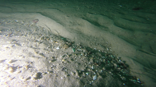
    ImageDescription: Image grab of the sea floor on Stellwagen Bank from survey 2014-066-FA
    Artist: Page C. Valentine
    Copyright: Public Domain - please credit the U.S. Geological Survey
    UserComment: Image part of USGS data release https://doi.org/10.5066/P9EQM8MK
    
    
    IPTC tags: The tag is listed along with the information used to populate it - which is the same for every image.
    
    Credit: U.S. Geological Survey
    Contact: WHSC_data_contact@usgs.gov
    keywords: Stellwagen Bank, Massachusetts, 2014-066-FA, SEABOSS, sea floor, USGS, ground-truth, https://doi.org/10.5066/P9EQM8MK
    CopyrightNotice: Public Domain - please credit U.S. Geological Survey
    Caption-Abstract: Image grab of the sea floor on Stellwagen Bank from survey 2014-066-FA
    
    
    XMP tags: The tag is listed along with the information used to populate it - which is the same for every image.
    
    Caption: Image grab of the sea floor on Stellwagen Bank from survey 2014-066-FA
    
    
    To extract the information from the image headers using ExifTool, the following command can be used (tested with ExifTool version 11.54):
    
    
    exiftool.exe -csv -f -filename -GPSTimeStamp -GPSDateStamp -GPSLongitude -GPSLatitude -n -Artist -Credit -comment -keywords -Caption -Copyright -CopyrightNotice -Caption-Abstract -ImageDescription -UserComment *.jpg > out.csv
    
    
    The -csv flag writes the information out in a comma-delimited format. The -n option formats the latitude and longitude as signed decimal degrees. Whether you use exiftool or exiftool.exe will depend on the system on which the command is being run. Person who carried out this activity:
    U.S. Geological Survey
    Attn: VeeAnn A. Cross
    Marine Geologist
    384 Woods Hole Road
    Woods Hole, MA

    508-548-8700 x2251 (voice)
    508-457-2310 (FAX)
    vatnipp@usgs.gov
    Date: 08-Sep-2020 (process 5 of 5)
    Added keywords section with USGS persistent identifier as theme keyword. Person who carried out this activity:
    U.S. Geological Survey
    Attn: VeeAnn A. Cross
    Marine Geologist
    384 Woods Hole Road
    Woods Hole, MA

    508-548-8700 x2251 (voice)
    508-457-2310 (FAX)
    vatnipp@usgs.gov
  3. What similar or related data should the user be aware of?
    Blackwood, D.S., and Parolski, K.F., 2001, Seabed observation and sampling system: Sea Technology v. 42, no. 2, p.39-43.

    Valentine, P., Blackwood, D., and Parolski, K., 2000, Seabed observation and sampling system: U.S. Geological Survey Fact Sheet FS-142-00, U.S. Geological Survey, Reston, VA.

    Online Links:

    Valentine, Page C., and Cross, VeeAnn A., 2019, Location and analyses of sediment samples collected on Stellwagen Bank off Boston, Massachusetts from November 5, 2013 to April 30, 2019 on U.S. Geological Survey field activities: data release DOI:10.5066/P9FWFLPD, U.S. Geological Survey, Reston, VA.

    Online Links:

    Other_Citation_Details:
    This publication includes the sediment sample analyses information associated with this field activity and 19 other field activities.

How reliable are the data; what problems remain in the data set?

  1. How well have the observations been checked?
  2. How accurate are the geographic locations?
    Although the images do not represent spatial data, the spatial information is available in the EXIF header of each image, which is derived from the station location in the station data summary file (available from the Larger Work citation). The location information for stations was acquired from a satellite navigation receiver (Furuno satellite compass SC-30, GPS receiver) with a horizontal accuracy of 10 m. Navigation data was recorded within a range of 2 sec to 1 min 3 sec due to a problem with the GPS receiver. The navigation antenna is located 5.3 m forward of the SEABOSS deployment location. This offset was not accounted for in the navigation acquisition (navigation fixes represent antenna location).
  3. How accurate are the heights or depths?
  4. Where are the gaps in the data? What is missing?
    Each station has 2 images - one showing a broader view of the landscape and the second a close-up of the seabed that was recorded when sampling was attempted. With 44 stations, this makes a total of 88 JPEG images. In some images from shallow depths, ambient daylight is the dominant light source and causes the images to have a “greenish” coloration.
  5. How consistent are the relationships among the observations, including topology?
    The image names are in the format staXXXX_Y.jpg where XXXX is the station number and Y is the image number at that station. Each station has 2 images - one showing a broader view of the landscape (Y=1) and the second a close-up of the seabed (Y=2). The difference in view is related to the closeness of the SEABOSS to the seafloor. See the cross-references for a description of SEABOSS. The two images from a station are not from the same geographic location on the video drift, but the EXIF header information in each is the same. This is because the video source imagery did not display time. The latitude and longitude of the two images is based on the station location time recorded in the cruise logbook (the location of a sediment sample, or if no sample was collected, the video drift end location). The latitude and longitude of a station recorded in the logbook were later adjusted to match the latitude and longitude recorded at that time in the GPS navigation file. The 2014-066-FA_station_data_summary (available from the Larger Work citation) station locations are the same as the image locations at each station. Typically the station numbers are sequential starting with 42. There are four exceptions to this – stations 4417, 4418, 4419 and 4420. The original field number had to be replaced because that original value had been used on another cruise.

How can someone get a copy of the data set?

Are there legal restrictions on access or use of the data?
Access_Constraints: None.
Use_Constraints: None.
  1. Who distributes the data set? (Distributor 1 of 1)
    U.S. Geological Survey
    Attn: Page C. Valentine
    Research Geologist
    384 Woods Hole Rd.
    Woods Hole, MA
    USA

    (508) 548-8700 x2239 (voice)
    (508) 457-2310 (FAX)
    pvalentine@usgs.gov
  2. What's the catalog number I need to order this data set? 2014-066-FA_SeabedImages.zip contains the 88 JPEG images that are grabs from the video (2 images at each station), the browse graphic (2014-066-FA_seabedimage_browse.jpg) and the FGDC CSDGM metadata in TXT, XML, and HTML formats.
  3. What legal disclaimers am I supposed to read?
    Neither the U.S. Government, the Department of the Interior, nor the USGS, nor any of their employees, contractors, or subcontractors, make any warranty, express or implied, nor assume any legal liability or responsibility for the accuracy, completeness, or usefulness of any information, apparatus, product, or process disclosed, nor represent that its use would not infringe on privately owned rights. The act of distribution shall not constitute any such warranty, and no responsibility is assumed by the USGS in the use of these data or related materials. Any use of trade, product, or firm names is for descriptive purposes only and does not imply endorsement by the U.S. Government.
  4. How can I download or order the data?
  5. What hardware or software do I need in order to use the data set?
    The ZIP file contains images in JPEG format. The user must have software capable of uncompressing the ZIP file and viewing the JPEG images.

Who wrote the metadata?

Dates:
Last modified: 08-Sep-2020
Metadata author:
U.S. Geological Survey
Attn: VeeAnn A. Cross
Marine Geologist
384 Woods Hole Rd.
Woods Hole, MA

508-548-8700 x2251 (voice)
508-457-2310 (FAX)
vatnipp@usgs.gov
Metadata standard:
FGDC Content Standards for Digital Geospatial Metadata (FGDC-STD-001-1998)

This page is <https://cmgds.marine.usgs.gov/catalog/whcmsc/field_activities/2014_066_fa/2014-066-FA_SeabedImages_meta.faq.html>
Generated by mp version 2.9.50 on Tue Sep 21 18:20:15 2021