Citation:
Citation_Information:
Originator: Valerie Paskevich
Publication_Date: 2000
Title:
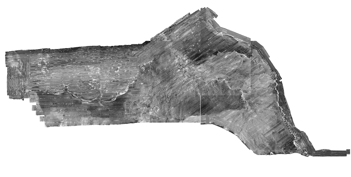
GLORIA sidescan sonar mosaic (Geographic, NAD27, white background)
Edition: 1.0
Geospatial_Data_Presentation_Form: remote-sensing image
Series_Information:
Series_Name: Open-File Report
Issue_Identification: 2000-019
Publication_Information:
Publication_Place: U.S. Geological Survey, Woods Hole, MA
Publisher: USGS Coastal and Marine Geology Team
Online_Linkage: https://doi.org/10.3133/ofr0019
Online_Linkage: https://pubs.usgs.gov/of/2000/of00-019/htmldocs/data.htm
Larger_Work_Citation:
Citation_Information:
Originator: Valerie F. Paskevich
Publication_Date: 2000
Title:
Gulf of Mexico GLORIA sidescan sonar geologic interpretation: ArcView data coverages
Edition: 1.0
Geospatial_Data_Presentation_Form: raster digital data; vector data
Series_Information:
Series_Name: Open-File Report
Issue_Identification: 2000-019
Publication_Information:
Publication_Place: Reston, VA
Publisher: U.S. Geological Survey
Other_Citation_Details:
Suggested citation: Paskevich, V.F., 2000, Gulf of Mexico GLORIA sidescan sonar geologic interpretation—ArcView data coverages: U.S. Geological Survey Open-File Report 2000-019,
https://doi.org/10.3133/ofr0019 .
Description:
Abstract:
This GIS overlay is a component of the U. S Geological Survey, Woods Hole Field Center's, Gulf of Mexico ArcView GIS database. The Gulf of Mexico GIS database is intended to organize and display USGS held data and provide on-line (WWW) access to the data and/or metadata.
Purpose:
This ArcView GIS layer is a 250 m version of the composite Gulf of Mexico GLORIA sidescan sonar mosaic.
Time_Period_of_Content:
Time_Period_Information:
Multiple_Dates/Times:
Single_Date/Time:
Calendar_Date: 19820202
Single_Date/Time:
Calendar_Date: 19820224
Single_Date/Time:
Calendar_Date: 19870807
Single_Date/Time:
Calendar_Date: 19870903
Single_Date/Time:
Calendar_Date: 19851002
Single_Date/Time:
Calendar_Date: 19851022
Currentness_Reference:
data collection. 20250813 edit: Rather than single dates, the assumption is that these are a list of range of dates such as 19820202 to 19820224; 19870807 to 19870903; 19851002 to 19851022.
Status:
Progress: Complete
Maintenance_and_Update_Frequency: None planned
Spatial_Domain:
Bounding_Coordinates:
West_Bounding_Coordinate: -96
East_Bounding_Coordinate: -82
North_Bounding_Coordinate: 29.5
South_Bounding_Coordinate: 23
Keywords:
Theme:
Theme_Keyword_Thesaurus: USGS Metadata Identifier
Theme_Keyword: USGS:cdeeb6b0-357d-4137-90cc-841fc5ac9910
Theme:
Theme_Keyword_Thesaurus: None
Theme_Keyword: U.S. Geological Survey
Theme_Keyword: Woods Hole Field Center
Theme_Keyword: Gulf of Mexico database
Theme_Keyword: Exclusive Economic Zone
Theme_Keyword: EEZ
Theme_Keyword: GLORIA
Theme_Keyword: sidescan sonar
Theme_Keyword: sidescan sonar mosaic
Theme_Keyword: composite mosaic
Theme_Keyword: TIFF
Theme_Keyword: Geologic Long-Range Inclined Asdic
Theme_Keyword: Geotiff
Theme:
Theme_Keyword_Thesaurus: ISO 19115 Topic Category
Theme_Keyword: imageryBaseMapsEarthCover
Theme_Keyword: geoscientificInformation
Theme_Keyword: oceans
Theme:
Theme_Keyword_Thesaurus: USGS Thesaurus
Theme_Keyword: sea-floor acoustic reflectivity
Theme_Keyword: marine geology
Theme_Keyword: sea-floor characteristics
Theme_Keyword: sidescan sonar
Theme_Keyword: image mosaics
Place:
Place_Keyword_Thesaurus: None
Place_Keyword: Gulf of Mexico
Place_Keyword: U.S. EEZ
Place_Keyword: U.S. Exclusive Economic Zone
Access_Constraints: None
Use_Constraints:
The U.S. Geological Survey must be referenced as the originator of the dataset in any future products or research derived from these data.
Point_of_Contact:
Contact_Information:
Contact_Organization_Primary:
Contact_Organization: U. S. Geological Survey
Contact_Person: Valerie Paskevich
Contact_Position: Computer Specialist
Contact_Address:
Address_Type: mailing and physical address
Address: 384 Woods Hole Road
City: Woods Hole
State_or_Province: MA
Postal_Code: 02543-1598
Country: USA
Contact_Voice_Telephone: (508) 548-8700 x2281
Contact_Facsimile_Telephone: (508) 457-2281
Contact_Electronic_Mail_Address: [email protected]
Browse_Graphic:
Browse_Graphic_File_Name: latlon
Browse_Graphic_File_Description:
Browse_Graphic_File_Type:
250m mosaic of GLORIA sidescan sonar data on white background for the Gulf of Mexico
Native_Data_Set_Environment: GEOTIFF