Citation:
Citation_Information:
Originator: Jeffrey W. Nealon
Originator: William P. Dillon
Originator: William W. Danforth
Publication_Date: 2001
Title:
Deep-Towed Chirp Profiles of the Blake Ridge Collapse Structure Collected on USGS cruises 92023 and 95023 Aboard the R/V Cape Hatteras in 1992 and 1995
Series_Information:
Series_Name: U.S. Geological Survey Open-File Report
Issue_Identification: 01-123
Publication_Information:
Publication_Place: Woods Hole, MA
Publisher: U.S. Geological Survey
Online_Linkage: https://doi.org/10.3133/ofr01123
Online_Linkage: https://pubs.usgs.gov/of/2001/of01-123/
Description:
Abstract:
This CD-ROM contains copies of the navigation and deep-towed chirp subbottom data collected aboard the R/V Cape Hatteras,on cruises 92023 and 95023 in 1992 and 1995 respectively. This CD-ROM is (Compact Disc-Read Only Memory UDF (Universal Disc Format) CD-ROM Standard (ISO 9660 equivalent). The HTML documentation is written utilizing some HTML 4.0 enhancements. The disk should be viewable by all WWW browsers but may not properly format on some older WWW browsers. Also, some links to USGS collaborators and other agencies are available on this CD-ROM. These links are only accessible if access to the Internet is available during browsing of the CD-ROM. On cruise 92023, 58 km of deep-towed chirp data were recorded on 4 lines and broken into a total of 8 files. 78 square kilometers of sidescan mosaic and approximately 1000 km of air gun single channel seismic reflection data were recorded as well but are not achived on this report. On cruise 95023, 100km of deep- towed chirp data were recorded on 5 lines and broken into 18 files. 152 square kilometers of sidescan mosaic and 244.3 km of GI gun single channel seismic reflection were also recorded but are not archived on this report. The archived Chirp subbottom data are in standard Society of Exploration Geologists (SEG) SEG-Y format (Barry and others, 1975) and may be downloaded for processing with software such as Seismic Unix or SIOSEIS. The subbottom data were recorded on the ISIS data acquisition system in QMIPS format. Chirp subbottom channel extracted from raw QMIPS format sonar files and converted to 16-bit Int. SEG-Y format using the program QMIPSTOSEGY. Even though the data are in SEG-Y format, it is not the conventional time series data (e.g. voltages or pressures), but rather instantaneous amplitude or envelope detected and therefore all of the amplitudes are positive (though not simply rectified).
Purpose:
This study was completed as part of an ongoing project in the field of natural gas hydrate research. Natural gas hydrates are an ice-like crystalline combination of water and gas, most commonly methane. The data included in this report were collected in an effort to understand a site where we believe large quantities of methane, approximately 4% of the present atmospheric total, was released from seafloor sediments. This site is known as the Blake Ridge collapse structure, located 300 km off the South Carolina coast at approximately 2600 m of water depth.
Supplemental_Information:
Seismic reflection profiles are acquired by means of an acoustic source (usually generated electromagnetically or with compressed air), and a hydrophone or hydrophone array. Both elements are typically towed in the water behind a survey vessel, or some cases, mounted on side of the hull. The sound source emits a short acoustic pulse, which propagates through the water and sediment columns. The acoustic energy is reflected at density boundaries (such as the seafloor or sediment layers beneath the seafloor), and detected at the hydrophone. As the vessel moves, this process is repeated at intervals ranging between 0.5 and 20 meters depending on the source type. In this way, a two-dimensional image of the geologic structure beneath the ship track is constructed. For more information concerning seismic reflection profiling at the USGS Woods Hole
http://woodshole.er.usgs.gov/operations/sfmapping/ . Additional information on the field activities these data pertain to can be found at:
https://cmgds.marine.usgs.gov/fan_info.php?fan=1992-023-FA and
https://cmgds.marine.usgs.gov/fan_info.php?fan=1995-023-FA .
Time_Period_of_Content:
Time_Period_Information:
Range_of_Dates/Times:
Beginning_Date: 19921002
Beginning_Time: 164342
Ending_Date: 19951016
Ending_Time: 205000
Currentness_Reference:
data acquisition date range. These data are from 2 separate cruise. The first cruise occurred in 1992 from Sept. 21 to Oct. 4. The second cruise occurred in 1995 from Oct. 11 to Oct. 19.
Status:
Progress: Complete
Maintenance_and_Update_Frequency: None planned
Spatial_Domain:
Bounding_Coordinates:
West_Bounding_Coordinate: -76.03
East_Bounding_Coordinate: -75.36
North_Bounding_Coordinate: 32.03
South_Bounding_Coordinate: 31.76
Keywords:
Theme:
Theme_Keyword_Thesaurus: USGS Metadata Identifier
Theme_Keyword: USGS:4e61d4c3-fb62-4919-8bb3-297c61ef31f3
Theme:
Theme_Keyword_Thesaurus: None
Theme_Keyword: seismic reflection
Theme_Keyword: SEG-Y
Theme_Keyword: Chirp
Theme_Keyword: Datasonics SIS-7000
Theme_Keyword: high resolution
Theme:
Theme_Keyword_Thesaurus: USGS Thesaurus
Theme_Keyword: sub-bottom profiling
Theme_Keyword: navigational data
Theme_Keyword: marine geology
Theme_Keyword: sea-floor characteristics
Theme_Keyword: seismic reflection methods
Theme_Keyword: marine geophysics
Theme_Keyword: geospatial datasets
Theme:
Theme_Keyword_Thesaurus: ISO 19115 Topic Category
Theme_Keyword: geoscientificInformation
Place:
Place_Keyword_Thesaurus: None
Place_Keyword: Atlantic Ocean
Place_Keyword: Blake Ridge
Place_Keyword: Blake Ridge collapse structure
Place_Keyword: South Carolina
Place_Keyword: Duke Marine Lab
Place_Keyword: USGS
Place_Keyword: Woods Hole Field Center (WHFC)
Place_Keyword: Eastern Regional Center
Access_Constraints:
The U.S. Geological Survey must be referenced as the originator of the
datasetin any future products or research derived from these data.
Use_Constraints: None
Point_of_Contact:
Contact_Information:
Contact_Person_Primary:
Contact_Person: Dillon, William P.
Contact_Organization: U.S. Geological Survey
Contact_Position: Gas Hydrates Project
Contact_Address:
Address_Type: mailing address
Address: 384 Woods Hole Road
City: Woods Hole
State_or_Province: MA
Postal_Code: 02543-1598
Country: USA
Contact_Voice_Telephone: (508) 548-8700
Contact_Facsimile_Telephone: (508) 457-2310
Contact_Electronic_Mail_Address: [email protected]
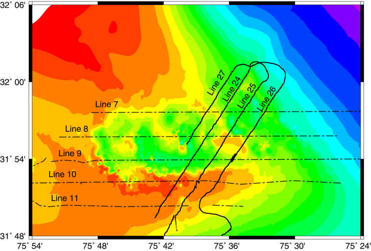
Browse_Graphic:
Browse_Graphic_File_Name:
Browse_Graphic_File_Description: Map of Chirp Survey Area
Browse_Graphic_File_Type: JPEG
Data_Set_Credit:
Nealon, Jeffrey; Dillon, William; Danforth William; O'Brien Thomas
Native_Data_Set_Environment: SEG-Y