5 Minute Navigation Points for R/V ASTERIAS 85-8 (AST85-8) (85_8NAVP)

Metadata also available as - [Questions & Answers] - [Parseable text] - [XML]

Metadata:

Identification_Information:
Citation:
Citation_Information:
Originator: Mary DiGiacomo-Cohen
Publication_Date: 2002
Title:
5 Minute Navigation Points for R/V ASTERIAS 85-8 (AST85-8) (85_8NAVP)
Edition: 1.0
Geospatial_Data_Presentation_Form: vector digital data
Series_Information:
Series_Name: U.S. Geological Survey Open-File Report
Issue_Identification: 2002-002
Publication_Information:
Publication_Place: Woods Hole, MA
Publisher: U.S. Geological Survey, Coastal and Marine Geology Program
Online_Linkage: https://doi.org/10.3133/ofr022
Online_Linkage: Larger_Work_Citation:
Citation_Information:
Originator: Larry Poppe
Originator: Valerie Paskevich
Publication_Date: 2002
Title:
Geological Framework Data from Long Island Sound, 1981-1990: A Digital Data Release
Geospatial_Data_Presentation_Form: atlas
Series_Information:
Series_Name: U.S. Geological Survey Open-File Report
Issue_Identification: 2002-002
Publication_Information:
Publication_Place: Woods Hole, MA
Publisher: U.S. Geological Survey, Coastal and Marine Geology Program
Online_Linkage: https://doi.org/10.3133/ofr022
Description:
Abstract:
This GIS layer contains the shiptrack navigation points collected aboard the RV ASTERIAS during a 1985 geophysical cruise to western Long Island Sound. A boomer seismic system was used to collect the subbottom data.
Purpose:
The purpose is to disseminate a digital version of a regional map showing the distribution of sub-bottom seismic profiles (boomer) collected in western Long Island Sound aboard the R/V ASTERIAS during 1985. The seismic data collected along these ship tracks can be used to provide useful information about the framework geology in this region.
Supplemental_Information:
For more information about the field activity associated with this cruise, see https://cmgds.marine.usgs.gov/fan_info.php?fan=1985-016-FA.
Time_Period_of_Content:
Time_Period_Information:
Range_of_Dates/Times:
Beginning_Date: 19850520
Ending_Date: 19850529
Currentness_Reference: ground condition
Status:
Progress: Complete
Maintenance_and_Update_Frequency: None planned
Spatial_Domain:
Bounding_Coordinates:
West_Bounding_Coordinate: -73.762444
East_Bounding_Coordinate: -72.524887
North_Bounding_Coordinate: 41.187756
South_Bounding_Coordinate: 40.846329
Keywords:
Theme:
Theme_Keyword_Thesaurus: USGS Metadata Identifier
Theme_Keyword: USGS:5af9cf87-6809-4aa9-8e74-4bb710c58dbd
Theme:
Theme_Keyword_Thesaurus: None
Theme_Keyword: U.S. Geological Survey
Theme_Keyword: USGS
Theme_Keyword: Coastal and Marine Geology Team
Theme_Keyword: Coastal and Marine Geology Program
Theme_Keyword: Woods Hole Field Center
Theme_Keyword: Connecticut Department of Environmental Protection
Theme_Keyword: ArcView
Theme_Keyword: arcview
Theme_Keyword: shapefile
Theme_Keyword: points
Theme_Keyword: navigation
Theme_Keyword: geophysical data
Theme_Keyword: ship track
Theme_Keyword: boomer data
Theme_Keyword: ASTERIAS
Theme_Keyword: 1985
Theme_Keyword: AST85-1
Theme_Keyword: Geographic Information System
Theme_Keyword: GIS
Theme_Keyword: ship's track
Theme:
Theme_Keyword_Thesaurus: ISO 19115 Topic Category
Theme_Keyword: oceans
Theme_Keyword: location
Theme:
Theme_Keyword_Thesaurus: USGS Thesaurus
Theme_Keyword: navigational data
Theme_Keyword: geospatial datasets
Theme_Keyword: marine geology
Theme_Keyword: marine geophysics
Theme_Keyword: sub-bottom profiling
Place:
Place_Keyword_Thesaurus: None
Place_Keyword: Long Island Sound
Place_Keyword: Connecticut
Place_Keyword: New York
Access_Constraints: None
Use_Constraints:
The U.S. Geological Survey must be referenced as the originator of the dataset in any future products or research derived from these data.
Although this derived data set and its lineage dataset have been used by the USGS, no warranty, expressed or implied, is made by the USGS as to the accuracy of the data and/or related materials. The act of distribution shall not constitute any such warranty, and no responsibility is assumed by the USGS in the use of these data or related materials.
Point_of_Contact:
Contact_Information:
Contact_Organization_Primary:
Contact_Organization: U.S. Geological Survey
Contact_Person: Larry Poppe
Contact_Position: Geologist
Contact_Address:
Address_Type: mailing and physical address
Address: 384 Woods Hole Road
City: Woods Hole
State_or_Province: MA
Postal_Code: 02543-1598
Country: USA
Contact_Voice_Telephone: (508) 548-8700 x2314
Contact_Facsimile_Telephone: (508) 457-2310
Contact_Electronic_Mail_Address: lpoppe@usgs.gov
Hours_of_Service: 0800-1600
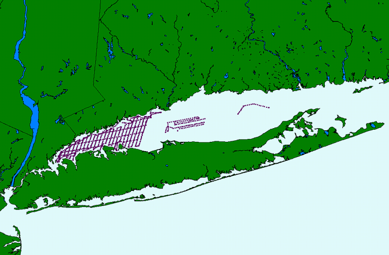
Browse_Graphic:
Browse_Graphic_File_Name: ../../../htmldocs/images/browse/85_8navp.gif
Browse_Graphic_File_Description:
R/V ASTERIAS cruise 85-8 extent of navigation lines shapefile shown in its spatial reference to Long Island Sound.
Browse_Graphic_File_Type: GIF
Data_Set_Credit:
Ralph Lewis the chief scientist aboard the cruise; Mary DiGiacomo-Cohen and Valerie Paskevich for completing the Arc processing and creation of the GIS data layer.
Native_Data_Set_Environment:
Microsoft Windows 2000 Version 5.0 (Build 2195) Service Pack 2; ESRI ArcCatalog 8.1.1.649
Cross_Reference:
Citation_Information:
Originator: Ralph S. Lewis
Originator: Janet R. Stone
Publication_Date: 1991
Title:
Late Quaternary Stratigraphy and Depositional History of the Long Island Sound Basin: Connecticut and New York
Geospatial_Data_Presentation_Form: map
Series_Information:
Series_Name: Journal of Coastal Research
Issue_Identification: special issue # 11
Publication_Information:
Publication_Place: Fort Lauderdale, FL
Publisher: Coastal Education and Research Foundation
Online_Linkage: https://www.jstor.org/stable/25735570
Data_Quality_Information:
Attribute_Accuracy:
Attribute_Accuracy_Report:
All attribute data were recorded by the chief scientist and entered and checked by the compilers in a consistent manner.
Logical_Consistency_Report:
No additional checks for topological consistency were performed on this data set.
Completeness_Report:
Complete information is provided for all navigation points in the data set. Navigation points are spaced at 5 minute intervals (approx) and at course changes or line events (start/end). Continous navigation is not available.
Positional_Accuracy:
Horizontal_Positional_Accuracy:
Horizontal_Positional_Accuracy_Report:
All navigation was done by Loran C. Typical Loran. Accuracy for LIS is about 100 m.
Quantitative_Horizontal_Positional_Accuracy_Assessment:
Horizontal_Positional_Accuracy_Value: 100
Horizontal_Positional_Accuracy_Explanation: Typical positioning accuracy of Loran C is +/-100 m
Lineage:
Source_Information:
Source_Citation:
Citation_Information:
Originator: Ralph S. Lewis
Originator: Nancy F. Neff
Publication_Date: Unknown
Title: Unpublished data from ASTERIAS 85-8 geophysical cruise
Geospatial_Data_Presentation_Form: map
Larger_Work_Citation:
Citation_Information:
Originator: Ralph S. Lewis
Originator: Mary DiGiacomo-Cohen
Publication_Date: 2000
Title:
A review of the Geological Framework of the Long Island Sound basin, with some observations relating to postglacial sedimentation
Geospatial_Data_Presentation_Form: map
Series_Information:
Series_Name: Journal of Coastal Research
Issue_Identification: vol. 16, no. 3
Publication_Information:
Publication_Place: Fort Lauderdale, FL
Publisher: Coastal Education and Research Foundation
Online_Linkage: https://journals.flvc.org/jcr/article/view/80857
Source_Scale_Denominator: 80,000
Type_of_Source_Media:
High-resolution seismic-reflection boomer lines navigated with Loran C
Source_Time_Period_of_Content:
Time_Period_Information:
Single_Date/Time:
Calendar_Date: 1985
Source_Currentness_Reference: publication date
Source_Citation_Abbreviation: ASTERIAS 85-8 navigation logs
Source_Contribution:
High-resolution seismic-reflection data were collected during field work conducted in western Long Island Sound during 1985. This data set is the navigation from that cruise.
Process_Step:
Process_Description:
Selected navigation points from the original onboard logs were hand plotted on charts with Loran overlays. These overlays were then registered and digitized (using a Calcomp 9100 table and PC Arc/Info) to create point coverages with CT state plane coordinates. Attributes were added.
Source_Used_Citation_Abbreviation: ASTERIAS 85-8 navigation logs
Process_Date: 1990
Source_Produced_Citation_Abbreviation: Ast85_8 navigation coverages
Process_Contact:
Contact_Information:
Contact_Organization_Primary:
Contact_Organization: Connecticut DEP
Contact_Person: Mary DiGiacomo-Cohen
Contact_Address:
Address_Type: mailing and physical address
Address:
Long Island Sound Resource Center
UCONN Avery Point
1080 Shennecossett Road
City: Groton
State_or_Province: CT
Postal_Code: 06340
Country: USA
Contact_Voice_Telephone: (860) 405-9015
Contact_Electronic_Mail_Address: lisrc@uconnvm.uconn.edu
Process_Step:
Process_Description:
The navigation coverage was projected to Latitude/Longitude using Arc/Info. Decimal degree coordinates were ungenerated and joined to the attribute table. A shapefile was generated using ArcView.
Source_Used_Citation_Abbreviation: Ast85_8 navigation coverages
Process_Date: 2001
Source_Produced_Citation_Abbreviation: Ast85_8 navigation shapefiles
Process_Contact:
Contact_Information:
Contact_Organization_Primary:
Contact_Organization: Connecticut DEP
Contact_Person: Mary DiGiacomo-Cohen
Contact_Address:
Address_Type: mailing and physical address
Address:
Long Island Sound Resource Center
UCONN Avery Point
1080 Shennecossett Rd
City: Groton
State_or_Province: CT
Postal_Code: 06340
Country: USA
Contact_Voice_Telephone: (860) 405-9015
Contact_Electronic_Mail_Address: lisrc@uconnvm.uconn.edu
Process_Step:
Process_Description:
The a85_8l shapefile name was changed to be more descriptive within the USGS Open-File Report 02-002.
Source_Used_Citation_Abbreviation: Ast85_8 navigation shapefiles
Process_Date: 20020406
Source_Produced_Citation_Abbreviation: 85_8navp.dbf
Source_Produced_Citation_Abbreviation: 85_8navp.shp
Source_Produced_Citation_Abbreviation: 85_8navp.shx
Source_Produced_Citation_Abbreviation: 85_8navp.sbn
Source_Produced_Citation_Abbreviation: 85_8navp.sbx
Process_Contact:
Contact_Information:
Contact_Person_Primary:
Contact_Person: Valerie Paskevich
Contact_Organization: U.S. Geological Survey
Contact_Position: Computer Specialist
Contact_Address:
Address_Type: mailing and physical address
Address: 384 Woods Hole Road
City: Woods Hole
State_or_Province: MA
Postal_Code: 02543-1598
Country: USA
Contact_Voice_Telephone: (508) 548-8700 x2281
Contact_Facsimile_Telephone: (508) 457-2310
Contact_Electronic_Mail_Address: vpaskevich@usgs.gov
Process_Step:
Process_Description:
Navigation shapefiles were modified to delete the Arc/Info generated attribute fields.
Source_Used_Citation_Abbreviation: 85_8navp.dbf
Process_Date: 20020417
Source_Produced_Citation_Abbreviation: 85_8navp.dbf
Process_Contact:
Contact_Information:
Contact_Person_Primary:
Contact_Person: Valerie Paskevich
Contact_Organization: U.S. Geological Survey
Contact_Position: Computer Specialist
Contact_Address:
Address_Type: mailing and physical address
Address: 384 Woods Hole Road
City: Woods Hole
State_or_Province: MA
Postal_Code: 02543-1598
Country: USA
Contact_Voice_Telephone: (508) 548-8700 x2281
Contact_Facsimile_Telephone: (508) 457-2310
Contact_Electronic_Mail_Address: vpaskevich@usgs.gov
Process_Step:
Process_Description:
The metadata was edited to remove errors as well as update some information. Edits include updating the citation section with the DOI link and modifying the title, added the link to the field activity in the supplmental information section, added the USGS Thesaurus and ISO 19115 Topic Category thesaurus, added keywords section with USGS persistent identifier as theme keyword, added link to cross-reference, used a generic email address in metadata, replaced distribution liability with FSP statement. Other blank fields were deleted. The metadata date (20020418), but not the contact (except email and contact instructions) was updated. The metadata available from a harvester may supersede metadata available from the publication. Compare the metadata dates to determine which metadata file is most recent.
Process_Date: 20210818
Process_Contact:
Contact_Information:
Contact_Organization_Primary:
Contact_Organization: U.S. Geological Survey
Contact_Person: VeeAnn A. Cross
Contact_Position: Marine Geologist
Contact_Address:
Address_Type: Mailing and Physical
Address: 384 Woods Hole Road
City: Woods Hole
State_or_Province: MA
Postal_Code: 02543-1598
Contact_Voice_Telephone: 508-548-8700 x2251
Contact_Facsimile_Telephone: 508-457-2310
Contact_Electronic_Mail_Address: vatnipp@usgs.gov
Spatial_Data_Organization_Information:
Direct_Spatial_Reference_Method: Vector
Point_and_Vector_Object_Information:
SDTS_Terms_Description:
SDTS_Point_and_Vector_Object_Type: Entity point
Point_and_Vector_Object_Count: 1029
Spatial_Reference_Information:
Horizontal_Coordinate_System_Definition:
Geographic:
Latitude_Resolution: 0.000001
Longitude_Resolution: 0.000001
Geographic_Coordinate_Units: Decimal degrees
Geodetic_Model:
Horizontal_Datum_Name: North American Datum of 1927
Ellipsoid_Name: Clarke 1866
Semi-major_Axis: 6378206.400000
Denominator_of_Flattening_Ratio: 294.978698
Entity_and_Attribute_Information:
Detailed_Description:
Entity_Type:
Entity_Type_Label: 85_8navp
Entity_Type_Definition: shapefile attribute table
Entity_Type_Definition_Source: ESRI
Attribute:
Attribute_Label: FID
Attribute_Definition: Internal feature number.
Attribute_Definition_Source: ESRI
Attribute_Domain_Values:
Unrepresentable_Domain:
Sequential unique whole numbers that are automatically generated.
Attribute:
Attribute_Label: Shape
Attribute_Definition: Feature geometry.
Attribute_Definition_Source: ESRI
Attribute_Domain_Values:
Unrepresentable_Domain: Coordinates defining the features.
Attribute_Domain_Values:
Enumerated_Domain:
Enumerated_Domain_Value: Point
Enumerated_Domain_Value_Definition: ESRI point shapefile
Enumerated_Domain_Value_Definition_Source: ESRI
Attribute:
Attribute_Label: CRUISEID
Attribute_Definition:
Identifier given to cruise during which the navigation data were collected.
Attribute_Definition_Source: USGS
Attribute_Domain_Values:
Enumerated_Domain:
Enumerated_Domain_Value: AST85-8
Enumerated_Domain_Value_Definition: Assigned identifier for cruise R/V ASTERIAS 85-8
Enumerated_Domain_Value_Definition_Source:
USGS, Coastal and Marine Geology Program, Woods Hole Field Center, data archives
Beginning_Date_of_Attribute_Values: 19850520
Ending_Date_of_Attribute_Values: 19850529
Attribute:
Attribute_Label: LON
Attribute_Definition: Longitude in decimal degrees of the navigation point.
Attribute_Definition_Source: Chief Scientist
Attribute_Domain_Values:
Range_Domain:
Range_Domain_Minimum: -073.762444
Range_Domain_Maximum: -072.524887
Attribute_Units_of_Measure: Decimal degrees
Attribute_Measurement_Resolution: 0.000001
Beginning_Date_of_Attribute_Values: 19850520
Ending_Date_of_Attribute_Values: 19850529
Attribute:
Attribute_Label: LAT
Attribute_Definition: Latitude in decimal degrees of the navigation point.
Attribute_Definition_Source: Chief Scientist
Attribute_Domain_Values:
Range_Domain:
Range_Domain_Minimum: 40.846329
Range_Domain_Maximum: 41.187756
Attribute_Units_of_Measure: Decimal degrees
Attribute_Measurement_Resolution: 0.000001
Beginning_Date_of_Attribute_Values: 19850520
Ending_Date_of_Attribute_Values: 19850529
Attribute:
Attribute_Label: LINE
Attribute_Definition:
Number assigned to the seismic line for which the naavigation was collected
Attribute_Definition_Source: Chief Scientist
Attribute_Domain_Values:
Range_Domain:
Range_Domain_Minimum: 1
Range_Domain_Maximum: 107
Attribute_Units_of_Measure: lines
Beginning_Date_of_Attribute_Values: 19850520
Ending_Date_of_Attribute_Values: 19850529
Attribute:
Attribute_Label: TIME
Attribute_Definition: Local time at which the navigation was collected.
Attribute_Definition_Source: Cheif Scientists
Attribute_Domain_Values:
Enumerated_Domain:
Enumerated_Domain_Value: hours and minutes
Enumerated_Domain_Value_Definition: hours and minutes in military time
Enumerated_Domain_Value_Definition_Source: Not applicable
Beginning_Date_of_Attribute_Values: 19850520
Ending_Date_of_Attribute_Values: 19850529
Attribute:
Attribute_Label: LORANX
Attribute_Definition: LORAN navigation coordinate collected during cruise
Attribute_Definition_Source: US Coast Guard Loran-C radionavigation system
Attribute_Domain_Values:
Range_Domain:
Range_Domain_Minimum: 26360.0
Range_Domain_Maximum: 26946.3
Attribute_Units_of_Measure: loran time difference in microseconds
Attribute_Measurement_Resolution: 0.1
Beginning_Date_of_Attribute_Values: 19850520
Ending_Date_of_Attribute_Values: 19850529
Attribute:
Attribute_Label: LORANY
Attribute_Definition: LORAN navigation coordinate collected during cruise
Attribute_Definition_Source: US Coast Guard Loran-C radionavigation system
Attribute_Domain_Values:
Range_Domain:
Range_Domain_Minimum: 43918.6
Range_Domain_Maximum: 44025.2
Attribute_Units_of_Measure: loran time difference in microseconds
Attribute_Measurement_Resolution: 0.1
Beginning_Date_of_Attribute_Values: 19850520
Ending_Date_of_Attribute_Values: 19850529
Attribute:
Attribute_Label: DATE
Attribute_Definition: Date during which the navigation data was collected.
Attribute_Definition_Source: Chief Scientist
Attribute_Domain_Values:
Enumerated_Domain:
Enumerated_Domain_Value: MONTH/DAY/YEAR
Enumerated_Domain_Value_Definition: Months, Days, and Years
Enumerated_Domain_Value_Definition_Source: Chief Scientist
Beginning_Date_of_Attribute_Values: 19850520
Ending_Date_of_Attribute_Values: 19850529
Overview_Description:
Entity_and_Attribute_Overview:
This datalayer (navigation collected onboard the R/V ASTERIAS cruise 85-8 to western LIS) provides information about the location of seismic data used to interpret the geologic framework.
Entity_and_Attribute_Detail_Citation:
Geological Framework Data from Long Island Sound, 1981-1990: a digital release
Distribution_Information:
Distributor:
Contact_Information:
Contact_Organization_Primary:
Contact_Organization: U.S. Geological Survey
Contact_Person: Larry Poppe
Contact_Position: Geologist
Contact_Address:
Address_Type: mailing and physical address
Address: 384 Woods Hole Road
City: Woods Hole
State_or_Province: MA
Postal_Code: 02543-1598
Country: USA
Contact_Voice_Telephone: (508) 548-8700 x2314
Contact_Facsimile_Telephone: (508) 457-2310
Contact_Electronic_Mail_Address: lpoppe@usgs.gov
Resource_Description: Long Island Sound: 85_8navp.shp
Distribution_Liability:
Unless otherwise stated, all data, metadata and related materials are considered to satisfy the quality standards relative to the purpose for which the data were collected. Although these data and associated metadata have been reviewed for accuracy and completeness and approved for release by the U.S. Geological Survey (USGS), no warranty expressed or implied is made regarding the display or utility of the data for other purposes, nor on all computer systems, nor shall the act of distribution constitute any such warranty.
Standard_Order_Process:
Digital_Form:
Digital_Transfer_Information:
Format_Name: ArcView
Format_Version_Number: 3.2
Format_Specification: ESRI point shapefile
Format_Information_Content:
The seven ArcView shapefiles (85_8navp.dbf, 85_8navp.shp, 85_8navp.shx, 85_8navp.avl, 85_8navp.sbn, 85_8navp.sbx) comprising the navigation point data for the R/V ASTERIAS 85-8 cruise in western Long Island Sound and an ASCII copy of the metadata file.
File_Decompression_Technique: zip
Transfer_Size: 1
Digital_Transfer_Option:
Online_Option:
Computer_Contact_Information:
Offline_Option:
Offline_Media: DVD
Recording_Capacity:
Recording_Density: 4.7
Recording_Density_Units: Gbytes
Recording_Format: UDF
Compatibility_Information:
The user must have a system with a DVD drive capable of reading an UDF standard DVD-R disk. To browse the information contained on this disk, the user must also have a current version of WWW browser available. The user must also have the software installed on their computer system capable to unzip the archived file.
Fees: none
Standard_Order_Process:
Digital_Form:
Digital_Transfer_Information:
Format_Name: ASCII
Format_Version_Number: information unavailable from original metadata
Format_Specification: Comma delimited ASCII text file with field header record.
File_Decompression_Technique: no compression applied
Transfer_Size: 1
Digital_Transfer_Option:
Online_Option:
Computer_Contact_Information:
Offline_Option:
Offline_Media: CD-ROM
Recording_Capacity:
Recording_Density: 4.75
Recording_Density_Units: Gigabytes
Recording_Format: UDF
Compatibility_Information:
The user must have a system with a DVD drive capable of reading an UDF standard DVD-R disk. To browse the information contained on this disk, the user must also have a current version of WWW browser available. The user must also have the software installed on their computer system capable to unzip the archived file.
Fees: none
Custom_Order_Process: None
Technical_Prerequisites:
The AST85-8 point navigation overlay is available in an ArcView shapefile format. The user must have ESRI's ArcView 3.0 or greater software to read and process the data file. In lieu of Arcview, the user may utilize another GIS application package capable of importing the data.
Available_Time_Period:
Time_Period_Information:
Single_Date/Time:
Calendar_Date: 2002
Metadata_Reference_Information:
Metadata_Date: 20210901
Metadata_Contact:
Contact_Information:
Contact_Person_Primary:
Contact_Person: Valerie Paskevich
Contact_Organization: U.S. Geological Survey
Contact_Position: computer specialist
Contact_Address:
Address_Type: mailing and physical address
Address: 384 Woods Hole Road
City: Woods Hole
State_or_Province: MA
Postal_Code: 02543-1598
Country: USA
Contact_Voice_Telephone: (508) 548-8700 x2281
Contact_Facsimile_Telephone: (508) 457-2310
Contact_Electronic_Mail_Address: whsc_data_contact@usgs.gov
Contact_Instructions:
The metadata contact email address is a generic address in the event the metadata contact is no longer with the USGS.
Metadata_Standard_Name: FGDC Content Standards for Digital Geospatial Metadata
Metadata_Standard_Version: FGDC-STD-001-1998
Metadata_Time_Convention: local time

This page is <https://cmgds.marine.usgs.gov/catalog/whcmsc/open_file_report/ofr2002-002/85_8navp_meta.html>
Generated by mp version 2.9.50 on Tue Sep 21 18:20:17 2021