Online Links:
Online Links:
| Value | Definition |
|---|---|
| Point | point data |
| Value | Definition |
|---|---|
| AT-88-1 | identifier assigned to cruise R/V ATLANTIC TWIN 88-1 |
| Value | Definition |
|---|---|
| 09/18/88 | Date core was collected recorded as ASCII string. |
| 09/19/88 | Date core was collected recorded as ASCII string. |
| 09/20/88 | Date core was collected recorded as ASCII string. |
| 09/21/88 | Date core was collected recorded as ASCII string. |
| 09/88 | Date core was collected recorded as ASCII string. Day of month unknown. |
| Value | Definition |
|---|---|
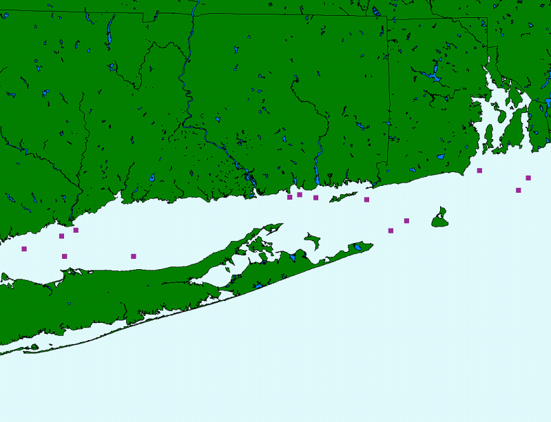
| AT88-1 thru AT88-14 | ASCII character string (AT88) followed by assigned sequential numeric integer of core |
| Range of values | |
|---|---|
| Minimum: | 41.023331 |
| Maximum: | 41.280003 |
| Units: | decimal degrees |
| Resolution: | 0.000001 |
| Range of values | |
|---|---|
| Minimum: | -72.093338 |
| Maximum: | -73.308334 |
| Units: | Decimal degrees |
| Resolution: | 0.000001 |
| Access_Constraints | None |
|---|---|
| Use_Constraints | The U.S. Geological Survey, Connecticut DEP, and the U.S. Minerals ManagementService must be referenced as the originators of the dataset in any future products or research derived from these data. Although this derived data set and its lineage dataset have been used by the USGS, no warranty, expressed or implied, is made by the USGS as to the accuracy of the data and/or related materials. The act of distribution shall not constitute any such warranty, and no responsibility is assumed by the USGS in the use of these data or related materials. |
| Data format: | The seven ArcView shapefiles (mms88.dbf, mms88.shp, mms88.shx, mms88.avl, mms88.sbn, mms88.sbx, mms88.prj) comprising the navigation point data for the AT88-1 vibracore cruise in Long Island Sound and an ASCII version of the metadata. in format ArcView shapefile (version 3.2) Size: 1 |
|---|---|
| Network links: |
https://doi.org/10.3133/ofr022 https://pubs.usgs.gov/of/2002/0002/data/cores/mms88/mms88.zip |
| Media you can order: |
DVD
(Density 4.7
Gbytes)
(format UDF)
Note: The user must have a system with a DVD drive capable of reading an UDF standard DVD-R disk. To browse the information contained on this disk, the user must also have a current version of WWW browser available. The user must also have the software installed on their computer system capable to unzip the archived file. |