Sediments on the Shelf off Southern New England (GARRISON66 shapefile)

Metadata also available as - [Questions & Answers] - [Parseable text] - [XML]

Metadata:

Identification_Information:
Citation:
Citation_Information:
Originator: Lawrence J. Poppe
Publication_Date: 2003
Title:
Sediments on the Shelf off Southern New England (GARRISON66 shapefile)
Edition: 1.0
Geospatial_Data_Presentation_Form: vector digital data
Series_Information:
Series_Name: Open-File Report
Issue_Identification: 03-001
Publication_Information:
Publication_Place: Woods Hole Coastal and Marine Science Center, Woods Hole, MA
Publisher: U. S. Geological Survey, Coastal and Marine Geology Program
Online_Linkage: https://doi.org/10.3133/ofr031
Online_Linkage: Online_Linkage: http://pubs.usgs.gov/of/2003/of03-001/htmldocs/data.htm
Larger_Work_Citation:
Citation_Information:
Originator: L.J. Poppe
Originator: V.F. Paskevich
Originator: S.J. Williams
Originator: M.E. Hastings
Originator: J.T. Kelley
Originator: D.F. Belknap
Originator: L.G. Ward
Originator: D.M. Fitzgerald
Originator: P.F. Larsen
Publication_Date: 2003
Title:
Surficial Sediment Data from the Gulf of Maine, Georges Bank, and vicinity: a GIS Compilation
Edition: 1.0
Geospatial_Data_Presentation_Form: vector digital data
Series_Information:
Series_Name: Open-File Report
Issue_Identification: 03-001
Publication_Information:
Publication_Place: Reston, VA
Publisher: U. S. Geological Survey
Other_Citation_Details: 1 CD-ROM
Online_Linkage: http://pubs.usgs.gov/of/2003/of03-001/
Description:
Abstract:
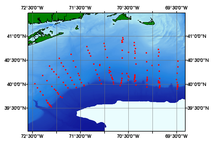
The sediments and geomorphology of a portion of the northeastern continental shelf between Hudson Canyon and Georges Bank have been investigated. Wave-cut terraces at 13, 45, 65, and 80 fathoms indicate four former low sea levels, while concentrations of beach ridges around 35 fathoms reveal a fifth. The pre-Holocene drainage pattern, still exposed over part of the area, shows that Block Channel was the main stream system which drained most of southern New England. The surface sediments on the western part of the study area are Late Pleistocene fluvial deposits. Overlying these coarse deposits in the central part of the outer shelf is a sandy silt facies that is also relict. The youngest facies and the only area of present deposition, is in the northeastern part where sand eroded from Nantucket Shoals is being deposited on the shelf.
Purpose:
The purpose of this data layer is to release a digital version of the sediment data published in Garrison and McMaster (1966).
Time_Period_of_Content:
Time_Period_Information:
Single_Date/Time:
Calendar_Date: 1966
Currentness_Reference: publication date
Status:
Progress: Complete
Maintenance_and_Update_Frequency: None planned
Spatial_Domain:
Bounding_Coordinates:
West_Bounding_Coordinate: -72.447000
East_Bounding_Coordinate: -69.467000
North_Bounding_Coordinate: 40.970000
South_Bounding_Coordinate: 39.533000
Keywords:
Theme:
Theme_Keyword_Thesaurus: USGS Metadata Identifier
Theme_Keyword: USGS:2c8ce206-8d15-4d40-b2f3-6172db3ea223
Theme:
Theme_Keyword_Thesaurus: None
Theme_Keyword: U.S. Geological Survey
Theme_Keyword: USGS
Theme_Keyword: Coastal and Marine Geology Program
Theme_Keyword: CMGP
Theme_Keyword: Woods Hole Field Center
Theme_Keyword: point shapefile
Theme_Keyword: sediments
Theme_Keyword: texture
Theme_Keyword: grabs
Theme_Keyword: cores
Theme_Keyword: lithology
Theme_Keyword: Open-File Report 03-001
Theme_Keyword: surficial classification
Theme_Keyword: sediment classification
Theme_Keyword: points
Theme_Keyword: GIS
Theme_Keyword: Geographic Information System
Theme_Keyword: WHSC
Theme:
Theme_Keyword_Thesaurus: ISO 19115 Topic Category
Theme_Keyword: oceans
Theme_Keyword: location
Theme_Keyword: geoscientificInformation
Theme:
Theme_Keyword_Thesaurus: USGS Thesaurus
Theme_Keyword: grain-size analysis
Theme_Keyword: navigational data
Theme_Keyword: geospatial datasets
Theme_Keyword: sea-floor characteristics
Theme_Keyword: marine geology
Place:
Place_Keyword_Thesaurus: None
Place_Keyword: U.S. East Coast
Place_Keyword: Block Island
Place_Keyword: Rhode Island Sound
Place_Keyword: continental shelf
Place_Keyword: New England
Place_Keyword: Atlantic
Place_Keyword: Georges Bank
Place_Keyword: Nantucket Shoals
Access_Constraints: None
Use_Constraints:
Public domain data from the U.S. Government are freely redistributable with proper metadata and source attribution. Please recognize the U.S. Geological Survey (USGS) as the source of this information.
Point_of_Contact:
Contact_Information:
Contact_Person_Primary:
Contact_Person: Lawrence J. Poppe
Contact_Organization: U.S. Geological Survey
Contact_Position: Geologist
Contact_Address:
Address_Type: mailing and physical address
Address: 384 Woods Hole Road
City: Woods Hole
State_or_Province: MA
Postal_Code: 02543-1598
Country: USA
Contact_Voice_Telephone: (508) 548-8700 x2314
Contact_Facsimile_Telephone: (508) 457-2310
Contact_Electronic_Mail_Address: lpoppe@usgs.gov
Browse_Graphic:
Browse_Graphic_File_Name: Browse_Graphic_File_Description:
ImThumbnail image map showing extent and distribution of data layer coverage.
Browse_Graphic_File_Type: GIF
Browse_Graphic:
Browse_Graphic_File_Name: Browse_Graphic_File_Description:
Image map showing extent and distribution of data layer coverage.
Browse_Graphic_File_Type: GIF
Data_Set_Credit:
Please review the cross section information for the original data set credit to L.E. Garrison and R.L. McMaster (1966). Larry Poppe for entering the data from the source report and creating the ArcView shapefile.
Native_Data_Set_Environment:
Microsoft Windows XP Version 5.1 (Build 2600) Service Pack 2; ESRI ArcCatalog 9.2.2.1350
Cross_Reference:
Citation_Information:
Originator: L.E. Garrison
Originator: R.L. McMaster
Publication_Date: 1966
Title:
Sediments and Geomorphology of the Continental Shelf off Southern New England
Edition: 1.0
Geospatial_Data_Presentation_Form: map
Series_Information:
Series_Name: Marine Geology
Issue_Identification: v. 4, p. 273-289.
Publication_Information:
Publication_Place: Amsterdam
Publisher: Elsevier
Data_Quality_Information:
Logical_Consistency_Report:
No additional checks for topological consistency were performed on this data.
Completeness_Report:
Sample locations and textural classifications are provided for 145 grab and coring stations.
Positional_Accuracy:
Horizontal_Positional_Accuracy:
Horizontal_Positional_Accuracy_Report:
Navagational methods are not discussed in the original report. Horizontal accuracy is unknown.
Vertical_Positional_Accuracy:
Vertical_Positional_Accuracy_Report: Tides are less han 2 m
Quantitative_Vertical_Positional_Accuracy_Assessment:
Vertical_Positional_Accuracy_Value: 2
Vertical_Positional_Accuracy_Explanation: Information unavailable from original metadata.
Lineage:
Source_Information:
Source_Citation:
Citation_Information:
Originator: L.E. Garrison
Originator: R.L. McMaster
Publication_Date: 1966
Title:
Sediments and Geomorphology of the Continental Shelf off Southern New England
Edition: 1.0
Series_Information:
Series_Name: Marine Geology
Issue_Identification: v. 4, p. 273-289.
Publication_Information:
Publication_Place: Amsterdam
Publisher: Elsevier
Type_of_Source_Media: paper
Source_Time_Period_of_Content:
Time_Period_Information:
Single_Date/Time:
Calendar_Date: 1966
Source_Currentness_Reference: publication date
Source_Citation_Abbreviation: Information unavailable from original metadata.
Source_Contribution: Information unavailable from original metadata.
Process_Step:
Process_Description:
The navigation was digitized from maps in the original paper. The remaining source information was manually entered into digital form and together were imported from an ASCII text file into an ArcView table. The table was later converted to an event theme in ArcView and saved as the final shapefile.
Source_Used_Citation_Abbreviation: garrison66.txt
Process_Date: 20020910
Source_Produced_Citation_Abbreviation: garrison66.shp
Source_Produced_Citation_Abbreviation: garrison66.dbf
Source_Produced_Citation_Abbreviation: garrison66.shx
Process_Contact:
Contact_Information:
Contact_Person_Primary:
Contact_Person: Lawrence J. Poppe
Contact_Organization: U.S. Geological Survey
Contact_Position: Geologist
Contact_Address:
Address_Type: mailing and physical address
Address: 384 Woods Hole Road
City: Woods Hole
State_or_Province: MA
Postal_Code: 02543-1598
Country: USA
Contact_Voice_Telephone: (508) 548-8700 x2314
Contact_Facsimile_Telephone: (508) 457-2310
Contact_Electronic_Mail_Address: lpoppe@usgs.gov
Process_Step:
Process_Description:
Edits to the metadata were made to fix any errors that MP v 2.9.32 flagged. This is necessary to enable the metadata to be successfully harvested for various data catalogs. In some cases, this meant adding text "Information unavailable" or "Information unavailable from original metadata" for those required fields that were left blank. Other minor edits were probably performed (title, publisher, publication place, etc.). The source information was incomplete and had to be modified to meet the standard. Minor fixes to the attribute format for some attributes was needed. The metadata date (but not the metadata creator) was edited to reflect the date of these changes. The metadata available from a harvester may supersede metadata bundled within a download file. Compare the metadata dates to determine which metadata file is most recent.
Process_Date: 20151201
Process_Contact:
Contact_Information:
Contact_Organization_Primary:
Contact_Organization: U.S. Geological Survey
Contact_Person: VeeAnn A. Cross
Contact_Position: Marine Geologist
Contact_Address:
Address_Type: mailing and physical address
Address: 384 Woods Hole Rd.
City: Woods Hole
State_or_Province: MA
Postal_Code: 02543
Contact_Voice_Telephone: 508-548-8700 x2251
Contact_Facsimile_Telephone: 508-457-2310
Contact_Electronic_Mail_Address: vatnipp@usgs.gov
Process_Step:
Process_Description: USGS Thesaurus keywords added to the keyword section.
Process_Date: 20180720
Process_Contact:
Contact_Information:
Contact_Organization_Primary:
Contact_Organization: U.S. Geological Survey
Contact_Person: VeeAnn A. Cross
Contact_Position: Marine Geologist
Contact_Address:
Address_Type: Mailing and Physical
Address: 384 Woods Hole Road
City: Woods Hole
State_or_Province: MA
Postal_Code: 02543-1598
Contact_Voice_Telephone: 508-548-8700 x2251
Contact_Facsimile_Telephone: 508-457-2310
Contact_Electronic_Mail_Address: vatnipp@usgs.gov
Process_Step:
Process_Description: Crossref DOI link was added as the first link in the metadata.
Process_Date: 20191118
Process_Contact:
Contact_Information:
Contact_Organization_Primary:
Contact_Organization: U.S. Geological Survey
Contact_Person: VeeAnn A. Cross
Contact_Position: Marine Geologist
Contact_Address:
Address_Type: Mailing and Physical
Address: 384 Woods Hole Road
City: Woods Hole
State_or_Province: MA
Postal_Code: 02543-1598
Contact_Voice_Telephone: 508-548-8700 x2251
Contact_Facsimile_Telephone: 508-457-2310
Contact_Electronic_Mail_Address: vatnipp@usgs.gov
Process_Step:
Process_Description:
Added keywords section with USGS persistent identifier as theme keyword.
Process_Date: 20200908
Process_Contact:
Contact_Information:
Contact_Organization_Primary:
Contact_Organization: U.S. Geological Survey
Contact_Person: VeeAnn A. Cross
Contact_Position: Marine Geologist
Contact_Address:
Address_Type: Mailing and Physical
Address: 384 Woods Hole Road
City: Woods Hole
State_or_Province: MA
Postal_Code: 02543-1598
Contact_Voice_Telephone: 508-548-8700 x2251
Contact_Facsimile_Telephone: 508-457-2310
Contact_Electronic_Mail_Address: vatnipp@usgs.gov
Spatial_Data_Organization_Information:
Direct_Spatial_Reference_Method: Vector
Point_and_Vector_Object_Information:
SDTS_Terms_Description:
SDTS_Point_and_Vector_Object_Type: Entity point
Point_and_Vector_Object_Count: 145
Spatial_Reference_Information:
Horizontal_Coordinate_System_Definition:
Geographic:
Latitude_Resolution: 0.000001
Longitude_Resolution: 0.000001
Geographic_Coordinate_Units: Decimal degrees
Geodetic_Model:
Horizontal_Datum_Name: North American Datum of 1927
Ellipsoid_Name: Clarke 1866
Semi-major_Axis: 6378206.400000
Denominator_of_Flattening_Ratio: 294.978698
Entity_and_Attribute_Information:
Detailed_Description:
Entity_Type:
Entity_Type_Label: garrison66.dbf
Entity_Type_Definition: Shapefile Attribute Table
Entity_Type_Definition_Source: ESRI
Attribute:
Attribute_Label: FID
Attribute_Definition: Internal feature number.
Attribute_Definition_Source: ESRI
Attribute_Domain_Values:
Unrepresentable_Domain:
Sequential unique whole numbers that are automatically generated.
Attribute:
Attribute_Label: Shape
Attribute_Definition: Feature geometry.
Attribute_Definition_Source: ESRI
Attribute_Domain_Values:
Unrepresentable_Domain: Coordinates defining the features.
Attribute:
Attribute_Label: CONSECNO
Attribute_Definition: Sample id assigned to distinguish between stations.
Attribute_Definition_Source: Complier
Attribute_Domain_Values:
Range_Domain:
Range_Domain_Minimum: 1
Range_Domain_Maximum: 145
Attribute_Units_of_Measure: integer count
Attribute_Measurement_Resolution: 1
Attribute:
Attribute_Label: PROJECTID
Attribute_Definition: Project id assigned to the data set for future identification.
Attribute_Definition_Source: Compiler
Attribute_Domain_Values:
Enumerated_Domain:
Enumerated_Domain_Value: GARRISON66
Enumerated_Domain_Value_Definition: Scientist and year of publication
Enumerated_Domain_Value_Definition_Source: Compiler
Attribute:
Attribute_Label: CRUISEID
Attribute_Definition: Abbreviation of ship name and cruise number.
Attribute_Definition_Source: Scientist
Attribute_Domain_Values:
Enumerated_Domain:
Enumerated_Domain_Value: TR-009
Enumerated_Domain_Value_Definition: Ship and cruise
Enumerated_Domain_Value_Definition_Source: Scientist
Attribute:
Attribute_Label: STATION
Attribute_Definition: Site at which a sample was taken
Attribute_Definition_Source: Scientist
Attribute_Domain_Values:
Unrepresentable_Domain: Assigned characters and numerics
Attribute:
Attribute_Label: DEVICE
Attribute_Definition: Specific grab or core used to collect a sample
Attribute_Definition_Source: Scientist
Attribute_Domain_Values:
Enumerated_Domain:
Enumerated_Domain_Value: SMITH-MACINTYRE GRAB
Enumerated_Domain_Value_Definition: Smith-MacIntyre Grab Sampler
Enumerated_Domain_Value_Definition_Source: Information unavailable from original metadata.
Attribute_Domain_Values:
Enumerated_Domain:
Enumerated_Domain_Value: VANVEEN GRAB
Enumerated_Domain_Value_Definition: VanVeen Grab Sampler
Enumerated_Domain_Value_Definition_Source: Information unavailable from original metadata.
Attribute_Domain_Values:
Enumerated_Domain:
Enumerated_Domain_Value: PISTON CORE
Enumerated_Domain_Value_Definition: Piston Core sampling device
Enumerated_Domain_Value_Definition_Source: Information unavailable from original metadata.
Attribute_Domain_Values:
Enumerated_Domain:
Enumerated_Domain_Value: GRAVITY CORE
Enumerated_Domain_Value_Definition: Gravity Core sampling device
Enumerated_Domain_Value_Definition_Source: Information unavailable from original metadata.
Attribute:
Attribute_Label: DATE
Attribute_Definition: Year, month and day when sample was collected
Attribute_Definition_Source: Scientist
Attribute_Domain_Values:
Unrepresentable_Domain: Character String; YYYMMDD
Attribute:
Attribute_Label: LATITUDE
Attribute_Definition: Latitude coordinates of sample location.
Attribute_Definition_Source: Scientist
Attribute_Domain_Values:
Range_Domain:
Range_Domain_Minimum: 39.5300
Range_Domain_Maximum: 40.9700
Attribute_Units_of_Measure: decimal degrees
Attribute_Measurement_Resolution: .0001
Attribute:
Attribute_Label: LONGITUDE
Attribute_Definition: Longitude of sample station.
Attribute_Definition_Source: Scientist
Attribute_Domain_Values:
Range_Domain:
Range_Domain_Minimum: -72.447
Range_Domain_Maximum: -69.467
Attribute_Units_of_Measure: decimal degrees
Attribute_Measurement_Resolution: .001
Attribute:
Attribute_Label: DEPTH
Attribute_Definition: Water depth in meters at the corresponding station.
Attribute_Definition_Source: Scientist
Attribute_Domain_Values:
Range_Domain:
Range_Domain_Minimum: 40
Range_Domain_Maximum: 355
Attribute_Units_of_Measure: meters
Attribute_Measurement_Resolution: 1
Attribute_Value_Accuracy_Information:
Attribute_Value_Accuracy: 1
Attribute_Value_Accuracy_Explanation: Information unavailable from original metadata.
Attribute:
Attribute_Label: DOMINANT_L
Attribute_Definition: Primarly lithology
Attribute_Definition_Source: Scientist
Attribute_Domain_Values:
Enumerated_Domain:
Enumerated_Domain_Value: SAND
Enumerated_Domain_Value_Definition: Sand content
Enumerated_Domain_Value_Definition_Source: Visual examination of sample by scientist
Attribute_Domain_Values:
Enumerated_Domain:
Enumerated_Domain_Value: MUD
Enumerated_Domain_Value_Definition: Mud content
Enumerated_Domain_Value_Definition_Source: Visual examination of sample by scientist
Attribute_Domain_Values:
Enumerated_Domain:
Enumerated_Domain_Value: CLAY
Enumerated_Domain_Value_Definition: Clay content
Enumerated_Domain_Value_Definition_Source: Visual examination of sample by scientist
Attribute_Domain_Values:
Enumerated_Domain:
Enumerated_Domain_Value: SILT
Enumerated_Domain_Value_Definition: Silt content
Enumerated_Domain_Value_Definition_Source: Visual examination of sample by scientist
Attribute:
Attribute_Label: SECOND_LIT
Attribute_Definition: Secondary lithology
Attribute_Definition_Source: Scientist
Attribute_Domain_Values:
Enumerated_Domain:
Enumerated_Domain_Value: CLAY
Enumerated_Domain_Value_Definition: Clay content
Enumerated_Domain_Value_Definition_Source: Visual examination of sample by scientist
Attribute_Domain_Values:
Enumerated_Domain:
Enumerated_Domain_Value: COARSER THAN SAND
Enumerated_Domain_Value_Definition: coarser than sand
Enumerated_Domain_Value_Definition_Source: Visual examination of sample by scientist
Attribute_Domain_Values:
Enumerated_Domain:
Enumerated_Domain_Value: SAND
Enumerated_Domain_Value_Definition: Sand content
Enumerated_Domain_Value_Definition_Source: Visual examination of sample by scientist
Attribute_Domain_Values:
Enumerated_Domain:
Enumerated_Domain_Value: SILT
Enumerated_Domain_Value_Definition: Silt content
Enumerated_Domain_Value_Definition_Source: Visual examination of sample by scientist
Attribute_Domain_Values:
Unrepresentable_Domain: Field is blank; no secondary lithology assigned
Attribute:
Attribute_Label: GRAVEL
Attribute_Definition: Percentage of gravel in a sample
Attribute_Definition_Source: Scientist
Attribute_Domain_Values:
Range_Domain:
Range_Domain_Minimum: 0
Range_Domain_Maximum: 39
Attribute_Units_of_Measure: percent
Attribute_Measurement_Resolution: 0.01
Attribute:
Attribute_Label: SAND
Attribute_Definition: Percentage of sand in a sample.
Attribute_Definition_Source: Scientist
Attribute_Domain_Values:
Range_Domain:
Range_Domain_Minimum: 0
Range_Domain_Maximum: 99.8
Attribute_Units_of_Measure: percent
Attribute_Measurement_Resolution: 0.01
Attribute:
Attribute_Label: SILT
Attribute_Definition: Percentage of silt in a sample
Attribute_Definition_Source: Scientist
Attribute_Domain_Values:
Range_Domain:
Range_Domain_Minimum: 0
Range_Domain_Maximum: 83.59
Attribute_Units_of_Measure: percent
Attribute_Measurement_Resolution: 0.01
Attribute:
Attribute_Label: CLAY
Attribute_Definition: Percentage of clay in a sample
Attribute_Definition_Source: Scientist
Attribute_Domain_Values:
Range_Domain:
Range_Domain_Minimum: 0
Range_Domain_Maximum: 40.52
Attribute_Units_of_Measure: percent
Attribute_Measurement_Resolution: 0.01
Attribute:
Attribute_Label: SHEPARD_CL
Attribute_Definition:
Classification of the sediment size distribution based on a scheme devied by Shepard (1954)
Attribute_Definition_Source: Compiler
Attribute_Domain_Values:
Unrepresentable_Domain:
Character string; Verbal equivalents of the Shephard classification scheme
Attribute_Domain_Values:
Enumerated_Domain:
Enumerated_Domain_Value: SAND
Enumerated_Domain_Value_Definition: Sand content
Enumerated_Domain_Value_Definition_Source: Data Compiler
Attribute_Domain_Values:
Enumerated_Domain:
Enumerated_Domain_Value: SAND SILT CLAY
Enumerated_Domain_Value_Definition: sand, silt and clay content
Enumerated_Domain_Value_Definition_Source: Data Compiler
Attribute_Domain_Values:
Enumerated_Domain:
Enumerated_Domain_Value: SANDY SILT
Enumerated_Domain_Value_Definition: sandy silt content
Enumerated_Domain_Value_Definition_Source: Data Compiler
Attribute_Domain_Values:
Enumerated_Domain:
Enumerated_Domain_Value: SILT
Enumerated_Domain_Value_Definition: silt content
Enumerated_Domain_Value_Definition_Source: Data Compiler
Attribute_Domain_Values:
Enumerated_Domain:
Enumerated_Domain_Value: SILTY SAND
Enumerated_Domain_Value_Definition: silty sand content
Enumerated_Domain_Value_Definition_Source: Data Compiler
Attribute_Domain_Values:
Unrepresentable_Domain: Field is blank; no classification is assigned
Overview_Description:
Entity_and_Attribute_Overview:
Sediment grain-size data, textural classifications, lithologic descriptions, navigation, and identifiers for the samples collected aboard the Trident by Garrison and McMaster (1966)
Entity_and_Attribute_Detail_Citation: U.S. Geological Survey
Distribution_Information:
Distributor:
Contact_Information:
Contact_Person_Primary:
Contact_Person: Lawrence J. Poppe
Contact_Organization: U.S. Geological Survey
Contact_Position: Geologist
Contact_Address:
Address_Type: mailing and physical address
Address: 384 Woods Hole Road
City: Woods Hole
State_or_Province: MA
Postal_Code: 02543-1598
Country: USA
Contact_Voice_Telephone: (508) 548-8700 x2314
Contact_Facsimile_Telephone: (508) 457-2310
Contact_Electronic_Mail_Address: lpoppe@usgs.gov
Resource_Description: Downloadable Data
Distribution_Liability:
Although these data have been used by the U.S. Geological Survey (USGS), U.S. Department of the Interior (DOI), no warranty expressed or implied is made by the U.S. Geological Survey as to the accuracy of the data. The act of distribution shall not constitute any such warranty, and no responsibility is assumed by the USGS in the use of these data or related materials. Any use of trade, product, or firm names is for descriptive purposes only and does not imply endorsement by the U.S. Government.
Standard_Order_Process:
Digital_Form:
Digital_Transfer_Information:
Format_Name: SHP
Format_Version_Number: 3.2
Format_Specification: ESRI point shapefile
Format_Information_Content:
Five files (garrison66.shp, garrison66.dbf, garrison66.shx, garrison66.sbx, garrison66.sbn) comprising the ArcView point shapefile components, 'prj' and 'avl' files, metadata text file and browse graphic.
File_Decompression_Technique: zip
Transfer_Size: 0.004
Digital_Transfer_Option:
Online_Option:
Computer_Contact_Information: Access_Instructions: Data may be downloaded via the World Wide Web (WWW).
Offline_Option:
Offline_Media: CD-ROM
Recording_Capacity:
Recording_Density: 650
Recording_Density_Units: Mbytes
Recording_Format: ISO 9600
Compatibility_Information:
The user must have a computer system with a CD-ROM available. To browse the information contained on this CD-ROM, the user must have a current WWW browser available. The user must also have software installed on their computer to unzip the archived file.
Fees: None
Technical_Prerequisites:
These data are available in Environmental Systems Research Institute (ESRI) shapefile format. The user must have ArcGIS or ArcView 3.0 or greater software to read and process the data file. In lieu of ArcView or ArcGIS, the user may utilize another GIS application package capable of importing the data. A free data viewer, ArcExplorer, capable of displaying the data is available from ESRI at www.esri.com.
Available_Time_Period:
Time_Period_Information:
Single_Date/Time:
Calendar_Date: 2002
Metadata_Reference_Information:
Metadata_Date: 20211116
Metadata_Contact:
Contact_Information:
Contact_Person_Primary:
Contact_Person: Lawrence J. Poppe
Contact_Organization: U.S. Geological Survey
Contact_Position: Geologist
Contact_Address:
Address_Type: mailing and physical address
Address: 384 Woods Hole Road
City: Woods Hole
State_or_Province: MA
Postal_Code: 02543-1598
Country: USA
Contact_Voice_Telephone: (508) 548-8700 x2314
Contact_Facsimile_Telephone: (508) 457-2310
Contact_Electronic_Mail_Address: whsc_data_contact@usgs.gov
Contact_Instructions:
The metadata contact email address is a generic address in the event the metadata contact is no longer with the USGS or the email is otherwise invalid.
Metadata_Standard_Name: FGDC Content Standards for Digital Geospatial Metadata
Metadata_Standard_Version: FGDC-STD-001-1998
Metadata_Time_Convention: local time
Metadata_Access_Constraints: None
Metadata_Use_Constraints: None

This page is <https://cmgds.marine.usgs.gov/catalog/whcmsc/open_file_report/ofr2003-001/garrison66.shp.html>
Generated by mp version 2.9.50 on Tue Nov 16 10:06:29 2021