Citation:
Citation_Information:
Originator: Lawrence J. Poppe
Publication_Date: 2003
Title:
Lithologic Descriptions from the Continental Margin Program (HATHLITH71 shapefile)
Edition: 1.0
Geospatial_Data_Presentation_Form: vector digital data
Series_Information:
Series_Name: Open-File Report
Issue_Identification: 03-001
Publication_Information:
Publication_Place: Woods Hole Coastal and Marine Science Center, Woods Hole, MA
Publisher: U. S. Geological Survey, Coastal and Marine Geology Program
Online_Linkage: https://doi.org/10.3133/ofr031
Online_Linkage:
Online_Linkage: http://pubs.usgs.gov/of/2003/of03-001/htmldocs/data.htm
Larger_Work_Citation:
Citation_Information:
Originator: L.J. Poppe
Originator: V.F. Paskevich
Originator: S.J. Williams
Originator: M.E. Hastings
Originator: J.T. Kelley
Originator: D.F. Belknap
Originator: L.G. Ward
Originator: D.M. Fitzgerald
Originator: P.F. Larsen
Publication_Date: 2003
Title:
Surficial Sediment Data from the Gulf of Maine, Georges Bank, and vicinity: a GIS Compilation
Edition: 1.0
Geospatial_Data_Presentation_Form: vector digital data
Series_Information:
Series_Name: Open-File Report
Issue_Identification: 03-001
Publication_Information:
Publication_Place: Reston, VA
Publisher: U. S. Geological Survey
Other_Citation_Details: 1 CD-ROM
Online_Linkage: http://pubs.usgs.gov/of/2003/of03-001/
Description:
Abstract:
This data set contains lithologic information on bottom sediments from the Continental Margin Program. The program was a joint collaboration between the U.S. Geological Survey and the Woods Hole Oceanographic Institution during the 1960s to conduct a geological reconnaissance investigation of the continental shelf and slope off the Atlantic coast of the United States. Only those records without complete size analyses and only those stations from the Gulf of Maine, Georges Bank, and southeastern New England shelf and slope are included in this data set. Other stations where detailed textural analyses are available or are from other areas have been excluded. Furthermore, dredges were used to collect most of the bottom samples, resulting in winnowing that has resulted in lithologic descriptions that are texturally coarser than actually present. Care should be taken when using this dataset.
Purpose:
The purpose of this data layer is to make available a digital subset of the Hathaway data set. This subset contains information for those samples with lithologic descriptions, but no raw grain size data, and which are located in/on the Gulf of Maine, Georges Bank, and southeastern New England continental shelf.
Time_Period_of_Content:
Time_Period_Information:
Single_Date/Time:
Calendar_Date: 1971
Currentness_Reference: publication date
Status:
Progress: Complete
Maintenance_and_Update_Frequency: None planned
Spatial_Domain:
Bounding_Coordinates:
West_Bounding_Coordinate: -71.900000
East_Bounding_Coordinate: -63.533330
North_Bounding_Coordinate: 46.086670
South_Bounding_Coordinate: 39.236670
Keywords:
Theme:
Theme_Keyword_Thesaurus: USGS Metadata Identifier
Theme_Keyword: USGS:ed505b62-e43d-4dc7-b68d-59d0d4ac9a6c
Theme:
Theme_Keyword_Thesaurus: None
Theme_Keyword: U.S. Geological Survey
Theme_Keyword: USGS
Theme_Keyword: Coastal and Marine Geology Program
Theme_Keyword: Woods Hole Science Center
Theme_Keyword: lithology
Theme_Keyword: sediment
Theme_Keyword: texture
Theme_Keyword: Continental Margin Program
Theme_Keyword: Open-File Report 03-001
Theme_Keyword: CMGP
Theme_Keyword: sediment classification
Theme_Keyword: surficial classification
Theme_Keyword: point shapefile
Theme_Keyword: points
Theme_Keyword: GIS
Theme_Keyword: Geographic Information System
Theme_Keyword: WHSC
Theme:
Theme_Keyword_Thesaurus: ISO 19115 Topic Category
Theme_Keyword: oceans
Theme_Keyword: location
Theme_Keyword: geoscientificInformation
Theme:
Theme_Keyword_Thesaurus: USGS Thesaurus
Theme_Keyword: navigational data
Theme_Keyword: geospatial datasets
Theme_Keyword: sea-floor characteristics
Theme_Keyword: marine geology
Place:
Place_Keyword_Thesaurus: None
Place_Keyword: U.S. East Coast
Place_Keyword: Atlantic
Place_Keyword: continental shelf
Place_Keyword: continental slope
Place_Keyword: Georges Bank
Place_Keyword: Gulf of Maine
Place_Keyword: New England
Access_Constraints: None
Use_Constraints:
Public domain data from the U.S. Government are freely redistributable with proper metadata and source attribution. Please recognize the U.S. Geological Survey (USGS) as the source of this information.
Point_of_Contact:
Contact_Information:
Contact_Person_Primary:
Contact_Person: Lawrence J. Poppe
Contact_Organization: U.S. Geological Survey
Contact_Position: Geologist
Contact_Address:
Address_Type: mailing and physical address
Address: 384 Woods Hole Road
City: Woods Hole
State_or_Province: MA
Postal_Code: 02543-1598
Country: USA
Contact_Voice_Telephone: (508) 548-8700 x2314
Contact_Facsimile_Telephone: (508) 457-2310
Contact_Electronic_Mail_Address: [email protected]
Browse_Graphic:
Browse_Graphic_File_Name:
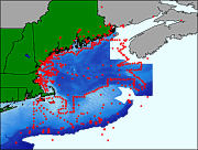
Browse_Graphic_File_Description:
Thumbnail image showing extent and distribution of data layer coverage.
Browse_Graphic_File_Type: GIF
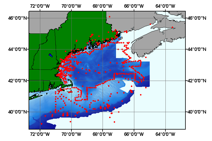
Browse_Graphic:
Browse_Graphic_File_Name:
Browse_Graphic_File_Description:
Image map showing extent and distribution of data layer coverage.
Browse_Graphic_File_Type: GIF
Data_Set_Credit:
Please review the cross reference information for the original data set credit to Hathaway (1971), and Larry Poppe for creating the ArcView shapefile.
Native_Data_Set_Environment:
Microsoft Windows XP Version 5.1 (Build 2600) Service Pack 2; ESRI ArcCatalog 9.2.2.1350
Cross_Reference:
Citation_Information:
Originator: J.C. Hathaway
Publication_Date: 1971
Title:
Data File: Continental Margin Program Atlantic Coast of the United States
Edition: 1.0
Series_Information:
Series_Name: Woods Hole Oceanographic Institution Reference
Issue_Identification: Number 71-15, v. 2, 496 p.
Publication_Information:
Publication_Place: Woods Hole, MA
Publisher: Woods Hole Oceanographc Institution