Citation:
Citation_Information:
Originator: Lawrence J. Poppe
Publication_Date: 2003
Title:
Sediments on the Shelf South of Martha's Vineyard (HOLLISTER69 shapefile)
Edition: 1.0
Geospatial_Data_Presentation_Form: vector digital data
Series_Information:
Series_Name: Open-File Report
Issue_Identification: 03-001
Publication_Information:
Publication_Place: Woods Hole Coastal and Marine Science Center, Woods Hole, MA
Publisher: U. S. Geological Survey, Coastal and Marine Geology Program
Online_Linkage: https://doi.org/10.3133/ofr031
Online_Linkage:
Online_Linkage: http://pubs.usgs.gov/of/2003/of03-001/htmldocs/data.htm
Larger_Work_Citation:
Citation_Information:
Originator: L.J. Poppe
Originator: V.F. Paskevich
Originator: S.J. Williams
Originator: M.E. Hastings
Originator: J.T. Kelley
Originator: D.F. Belknap
Originator: L.G. Ward
Originator: D.M. Fitzgerald
Originator: P.F. Larsen
Publication_Date: 2003
Title:
Surficial Sediment Data from the Gulf of Maine, Georges Bank, and vicinity: a GIS Compilation
Edition: 1.0
Geospatial_Data_Presentation_Form: vector digital data
Series_Information:
Series_Name: Open-File Report
Issue_Identification: 03-001
Publication_Information:
Publication_Place: Reston, VA
Publisher: U. S. Geological Survey
Other_Citation_Details: 1 CD-ROM
Online_Linkage: http://pubs.usgs.gov/of/2003/of03-001/
Description:
Abstract:
An unusual accumulation ofi ncohesive fine-grained sediment (silt and clay) occurs in the midst of the sand-covered continental shelf south of Martha's Vineyard. This 4000 square mile deposit of soft material is assumed to overlie relict Pleistocene sands. The objective of this study was to determine the distribution, thickness, and engineering properties of this fine-grained deposit.
Purpose:
The purpose of this data layer is to release a digital version of the sediment contained in Hollister and Korites (1969).
Time_Period_of_Content:
Time_Period_Information:
Single_Date/Time:
Calendar_Date: 1969
Currentness_Reference: publication date
Status:
Progress: Complete
Maintenance_and_Update_Frequency: None planned
Spatial_Domain:
Bounding_Coordinates:
West_Bounding_Coordinate: -71.716700
East_Bounding_Coordinate: -70.258300
North_Bounding_Coordinate: 40.700000
South_Bounding_Coordinate: 39.941700
Keywords:
Theme:
Theme_Keyword_Thesaurus: USGS Metadata Identifier
Theme_Keyword: USGS:c39774ca-9f1e-4883-914e-514db0ae15df
Theme:
Theme_Keyword_Thesaurus: None
Theme_Keyword: U.S. Geological Survey
Theme_Keyword: USGS
Theme_Keyword: Woods Hole Science Center
Theme_Keyword: WHOI
Theme_Keyword: Woods Hole Oceanographic Institution
Theme_Keyword: sediment grabs
Theme_Keyword: grabs
Theme_Keyword: sediment
Theme_Keyword: grain size
Theme_Keyword: sand
Theme_Keyword: silt
Theme_Keyword: clay
Theme_Keyword: Open-File Report 03-001
Theme_Keyword: Coastal and Marine Geology Program
Theme_Keyword: CMGP
Theme_Keyword: surficial classification
Theme_Keyword: sediment classification
Theme_Keyword: point shapefile
Theme_Keyword: points
Theme_Keyword: GIS
Theme_Keyword: Geographic Information System
Theme:
Theme_Keyword_Thesaurus: ISO 19115 Topic Category
Theme_Keyword: oceans
Theme_Keyword: location
Theme_Keyword: geoscientificInformation
Theme:
Theme_Keyword_Thesaurus: USGS Thesaurus
Theme_Keyword: grain-size analysis
Theme_Keyword: navigational data
Theme_Keyword: geospatial datasets
Theme_Keyword: sea-floor characteristics
Theme_Keyword: marine geology
Place:
Place_Keyword_Thesaurus: None
Place_Keyword: Martha's Vineyard
Place_Keyword: Mud Patch
Place_Keyword: Continental Shelf
Place_Keyword: Shelf
Place_Keyword: U.S. East Coast
Place_Keyword: Atlantic
Access_Constraints: None
Use_Constraints:
Public domain data from the U.S. Government are freely redistributable with proper metadata and source attribution. Please recognize the U.S. Geological Survey (USGS) as the source of this information.
Point_of_Contact:
Contact_Information:
Contact_Person_Primary:
Contact_Person: Lawrence J. Poppe
Contact_Organization: U.S. Geological Survey
Contact_Position: Geologist
Contact_Address:
Address_Type: mailing and physical address
Address: 384 Woods Hole Road
City: Woods Hole
State_or_Province: MA
Postal_Code: 02543-1598
Country: USA
Contact_Voice_Telephone: (508) 548-8700 x2314
Contact_Facsimile_Telephone: (508) 457-2310
Contact_Electronic_Mail_Address: lpoppe@usgs.gov
Browse_Graphic:
Browse_Graphic_File_Name:
Browse_Graphic_File_Description:
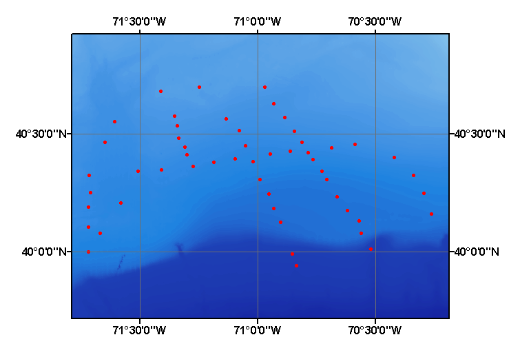
Thumbnail image showing extent and distribution of data layer coverage.
Browse_Graphic_File_Type: GIF
Browse_Graphic:
Browse_Graphic_File_Name:
Browse_Graphic_File_Description:
Image map showing extent and distribution of data layer coverage.
Browse_Graphic_File_Type: GIF
Data_Set_Credit:
Please review the cross reference information for the original data set credit to Hollister and Korites (1969). Polly Hastings for entering the data and Larry Poppe for creating the shapefile.
Native_Data_Set_Environment:
Microsoft Windows XP Version 5.1 (Build 2600) Service Pack 2; ESRI ArcCatalog 9.2.2.1350
Cross_Reference:
Citation_Information:
Originator: C.D. Hollister
Originator: B.J. Korites
Publication_Date: 1969
Title:
Distribution, Thickness, and Mechanical Properties of an Accumulation of Fine-Grained Sediment on the Continental Shelf South of Martha's Vineyard
Edition: 1.0
Series_Information:
Series_Name: Report
Issue_Identification: Report to the American Telephone and Telegraph Company, 18 p.
Publication_Information:
Publication_Place: Woods Hole, MA
Publisher: Woods Hole Oceanographic Institution