Army Corps Sediment Data from Maine and New Hampshire acquired in 1994 (MNHACOE shapefile)

Metadata also available as - [Questions & Answers] - [Parseable text] - [XML]

Metadata:

Identification_Information:
Citation:
Citation_Information:
Originator: Walter Barnhardt
Originator: Polly Hastings
Originator: Lawrence J. Poppe
Publication_Date: 2003
Title:
Army Corps Sediment Data from Maine and New Hampshire acquired in 1994 (MNHACOE shapefile)
Edition: 1.0
Geospatial_Data_Presentation_Form: vector digital data
Series_Information:
Series_Name: Open-File Report
Issue_Identification: 03-001
Publication_Information:
Publication_Place: Woods Hole Coastal and Marine Science Center, Woods Hole, MA
Publisher: U. S. Geological Survey, Coastal and Marine Geology Program
Online_Linkage: https://doi.org/10.3133/ofr031
Online_Linkage: Online_Linkage: http://pubs.usgs.gov/of/2003/of03-001/htmldocs/data.htm
Larger_Work_Citation:
Citation_Information:
Originator: L.J. Poppe
Originator: V.F. Paskevich
Originator: S.J. Williams
Originator: M.E. Hastings
Originator: J.T. Kelley
Originator: D.F. Belknap
Originator: L.G. Ward
Originator: D.M. Fitzgerald
Originator: P.F. Larsen
Publication_Date: 2003
Title:
Surficial Sediment Data from the Gulf of Maine, Georges Bank, and vicinity: a GIS Compilation
Edition: 1.0
Series_Information:
Series_Name: Open-File Report
Issue_Identification: 03-001
Publication_Information:
Publication_Place: Reston, VA
Publisher: U. S. Geological Survey
Other_Citation_Details: 1 CD-ROM
Online_Linkage: http://pubs.usgs.gov/of/2003/of03-001/
Description:
Abstract:
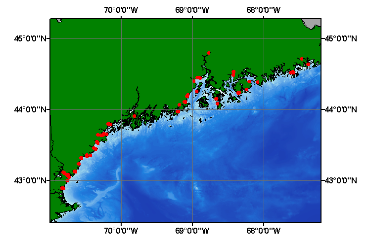
The data in this layer are from a study that evaluated and documented the historic and projected future dredging and dredged material disposal needs of the coastal rivers and harbors of the states of Maine and New Hampshire. Documentation of historic dredging and disposal activities was accomplished through the collection of data primarily from the files of the ACOE, New England Division, in Waltham, Massachusetts, supplemented by information from the states of Maine and New Hampshire and previously published reports. This historic dredging occurred between 1950-1993 and involved 499 dredging events.
Purpose:
The purpose of this data layer is to release a digital version of the sediment data published in Normandeau Associates (1994).
Time_Period_of_Content:
Time_Period_Information:
Single_Date/Time:
Calendar_Date: 1994
Currentness_Reference: publication date
Status:
Progress: Complete
Maintenance_and_Update_Frequency: None planned
Spatial_Domain:
Bounding_Coordinates:
West_Bounding_Coordinate: -70.824170
East_Bounding_Coordinate: -67.371630
North_Bounding_Coordinate: 44.800000
South_Bounding_Coordinate: 42.888180
Keywords:
Theme:
Theme_Keyword_Thesaurus: USGS Metadata Identifier
Theme_Keyword: USGS:6ff261d4-d8a6-46cd-825a-183c84841635
Theme:
Theme_Keyword_Thesaurus: None
Theme_Keyword: U.S. Geological Survey
Theme_Keyword: USGS
Theme_Keyword: USACOE
Theme_Keyword: ACOE
Theme_Keyword: U.S. Army Corps of Engineers
Theme_Keyword: sediment
Theme_Keyword: texture
Theme_Keyword: grain size
Theme_Keyword: gravel
Theme_Keyword: sand
Theme_Keyword: silt
Theme_Keyword: clay
Theme_Keyword: fines
Theme_Keyword: Open-File Report 03-001
Theme_Keyword: Woods Hole Science Center
Theme_Keyword: WHSC
Theme_Keyword: Coastal and Marine Geology Program
Theme_Keyword: CMGP
Theme_Keyword: sediment classification
Theme_Keyword: surficial classification
Theme_Keyword: point shapefile
Theme_Keyword: points
Theme_Keyword: GIS
Theme:
Theme_Keyword_Thesaurus: ISO 19115 Topic Category
Theme_Keyword: oceans
Theme_Keyword: location
Theme_Keyword: geoscientificInformation
Theme:
Theme_Keyword_Thesaurus: USGS Thesaurus
Theme_Keyword: grain-size analysis
Theme_Keyword: navigational data
Theme_Keyword: geospatial datasets
Theme_Keyword: sea-floor characteristics
Theme_Keyword: marine geology
Place:
Place_Keyword_Thesaurus: None
Place_Keyword: Maine
Place_Keyword: New Hampshire
Place_Keyword: New England
Place_Keyword: U.S. East Coast
Place_Keyword: Continental Shelf
Place_Keyword: Atlantic Ocean
Access_Constraints: None
Use_Constraints:
Public domain data from the U.S. Government are freely redistributable with proper metadata and source attribution. Please recognize the U.S. Geological Survey (USGS) as the source of this information.
Point_of_Contact:
Contact_Information:
Contact_Person_Primary:
Contact_Person: Lawrence J. Poppe
Contact_Organization: U.S. Geological Survey
Contact_Position: Geologist
Contact_Address:
Address_Type: mailing and physical address
Address: 384 Woods Hole Road
City: Woods Hole
State_or_Province: MA
Postal_Code: 02543-1598
Country: USA
Contact_Voice_Telephone: (508) 548-8700 x2314
Contact_Facsimile_Telephone: (508) 457-2310
Contact_Electronic_Mail_Address: lpoppe@usgs.gov
Browse_Graphic:
Browse_Graphic_File_Name: Browse_Graphic_File_Description:
Thumbnail image showing extent and distribution of data layer coverage.
Browse_Graphic_File_Type: GIF
Browse_Graphic:
Browse_Graphic_File_Name: Browse_Graphic_File_Description:
Image map showing extent and distribution of data layer coverage.
Browse_Graphic_File_Type: GIF
Data_Set_Credit:
Please review the cross section information for the original data set credit to Normandeau Associates (1994). Walter Barnhardt for entering the data from the source report and Larry Poppe for creating the ArcView shapefile.
Native_Data_Set_Environment:
Microsoft Windows XP Version 5.1 (Build 2600) Service Pack 2; ESRI ArcCatalog 9.2.2.1350
Cross_Reference:
Citation_Information:
Originator: Normandeau Associates, Inc.
Publication_Date: 1994
Title:
A Dredged Material Management Study for Coastal Maine and New Hampshire
Edition: 1.0
Series_Information:
Series_Name: Final report
Issue_Identification: R-13116.08, 220 p. plus appedicies
Publication_Information:
Publication_Place: Bedford, NH
Publisher: Normandeau Associates, Inc.
Data_Quality_Information:
Attribute_Accuracy:
Attribute_Accuracy_Report:
All attributes were entered and checked by the compilers in a consistent manner.
Logical_Consistency_Report:
No additional checks for topological consistency were performed on this data.
Completeness_Report:
Navigation, grain-size data, and identifiers are provided for 531 samples
Positional_Accuracy:
Horizontal_Positional_Accuracy:
Horizontal_Positional_Accuracy_Report:
The original studies were conducted over a number of years and navigational methods were not discussed in the Normandeau Associates report. Navigational accuracy is unknown.
Lineage:
Source_Information:
Source_Citation:
Citation_Information:
Originator: Normandeau Associates, Inc.
Publication_Date: 1994
Title:
A Dredged Material Management Study for Coastal Maine and New Hampshire
Edition: 1.0
Series_Information:
Series_Name: Final Report
Issue_Identification: R-13116.08, 220 p. plus appendicies
Publication_Information:
Publication_Place: Bedford, NH
Publisher: Normandeau Associates, Inc.
Type_of_Source_Media: paper
Source_Time_Period_of_Content:
Time_Period_Information:
Single_Date/Time:
Calendar_Date: 1994
Source_Currentness_Reference: publication date
Source_Citation_Abbreviation: Information unavailable from original metadata.
Source_Contribution: Information unavailable from original metadata.
Process_Step:
Process_Description:
The navigation and remaining source information was manually entered into digital form and imported from an ASCII text file into an ArcView table. The table was later converted to an event theme in ArcView and saved as the final shapefile.
Source_Used_Citation_Abbreviation: mnhacoe.txt
Process_Date: 20021204
Source_Produced_Citation_Abbreviation: mnhacoe.shp
Source_Produced_Citation_Abbreviation: mnhacoe.dbf
Source_Produced_Citation_Abbreviation: mnhacoe.shx
Process_Contact:
Contact_Information:
Contact_Person_Primary:
Contact_Person: Lawrence J. Poppe
Contact_Organization: U.S. Geological Survey
Contact_Position: Geologist
Contact_Address:
Address_Type: mailing and physical address
Address: 384 Woods Hole Road
City: Woods Hole
State_or_Province: MA
Postal_Code: 02543-1598
Country: USA
Contact_Voice_Telephone: (508) 548-8700 x2314
Contact_Facsimile_Telephone: (508) 457-2310
Contact_Electronic_Mail_Address: lpoppe@usgs.gov
Process_Step:
Process_Description:
Edits to the metadata were made to fix any errors that MP v 2.9.32 flagged. This is necessary to enable the metadata to be successfully harvested for various data catalogs. In some cases, this meant adding text "Information unavailable" or "Information unavailable from original metadata" for those required fields that were left blank. Other minor edits were probably performed (title, publisher, publication place, etc.). The source information was incomplete and had to be modified to meet the standard. The metadata date (but not the metadata creator) was edited to reflect the date of these changes. The metadata available from a harvester may supersede metadata bundled within a download file. Compare the metadata dates to determine which metadata file is most recent.
Process_Date: 20151202
Process_Contact:
Contact_Information:
Contact_Organization_Primary:
Contact_Organization: U.S. Geological Survey
Contact_Person: VeeAnn A. Cross
Contact_Position: Marine Geologist
Contact_Address:
Address_Type: mailing and physical address
Address: 384 Woods Hole Rd.
City: Woods Hole
State_or_Province: MA
Postal_Code: 02543
Contact_Voice_Telephone: 508-548-8700 x2251
Contact_Facsimile_Telephone: 508-457-2310
Contact_Electronic_Mail_Address: vatnipp@usgs.gov
Process_Step:
Process_Description: USGS Thesaurus keywords added to the keyword section.
Process_Date: 20180720
Process_Contact:
Contact_Information:
Contact_Organization_Primary:
Contact_Organization: U.S. Geological Survey
Contact_Person: VeeAnn A. Cross
Contact_Position: Marine Geologist
Contact_Address:
Address_Type: Mailing and Physical
Address: 384 Woods Hole Road
City: Woods Hole
State_or_Province: MA
Postal_Code: 02543-1598
Contact_Voice_Telephone: 508-548-8700 x2251
Contact_Facsimile_Telephone: 508-457-2310
Contact_Electronic_Mail_Address: vatnipp@usgs.gov
Process_Step:
Process_Description: Crossref DOI link was added as the first link in the metadata.
Process_Date: 20191118
Process_Contact:
Contact_Information:
Contact_Organization_Primary:
Contact_Organization: U.S. Geological Survey
Contact_Person: VeeAnn A. Cross
Contact_Position: Marine Geologist
Contact_Address:
Address_Type: Mailing and Physical
Address: 384 Woods Hole Road
City: Woods Hole
State_or_Province: MA
Postal_Code: 02543-1598
Contact_Voice_Telephone: 508-548-8700 x2251
Contact_Facsimile_Telephone: 508-457-2310
Contact_Electronic_Mail_Address: vatnipp@usgs.gov
Process_Step:
Process_Description:
Added keywords section with USGS persistent identifier as theme keyword.
Process_Date: 20200908
Process_Contact:
Contact_Information:
Contact_Organization_Primary:
Contact_Organization: U.S. Geological Survey
Contact_Person: VeeAnn A. Cross
Contact_Position: Marine Geologist
Contact_Address:
Address_Type: Mailing and Physical
Address: 384 Woods Hole Road
City: Woods Hole
State_or_Province: MA
Postal_Code: 02543-1598
Contact_Voice_Telephone: 508-548-8700 x2251
Contact_Facsimile_Telephone: 508-457-2310
Contact_Electronic_Mail_Address: vatnipp@usgs.gov
Spatial_Data_Organization_Information:
Direct_Spatial_Reference_Method: Vector
Point_and_Vector_Object_Information:
SDTS_Terms_Description:
SDTS_Point_and_Vector_Object_Type: Entity point
Point_and_Vector_Object_Count: 537
Spatial_Reference_Information:
Horizontal_Coordinate_System_Definition:
Geographic:
Latitude_Resolution: 0.00001
Longitude_Resolution: 0.00001
Geographic_Coordinate_Units: Decimal degrees
Geodetic_Model:
Horizontal_Datum_Name: North American Datum of 1927
Ellipsoid_Name: Clarke 1866
Semi-major_Axis: 6378206.400000
Denominator_of_Flattening_Ratio: 294.978698
Entity_and_Attribute_Information:
Detailed_Description:
Entity_Type:
Entity_Type_Label: mnhacoe.dbf
Entity_Type_Definition: Shapefile Attribute Table
Entity_Type_Definition_Source: ESRI
Attribute:
Attribute_Label: FID
Attribute_Definition: Internal feature number.
Attribute_Definition_Source: ESRI
Attribute_Domain_Values:
Unrepresentable_Domain:
Sequential unique whole numbers that are automatically generated.
Attribute:
Attribute_Label: Shape
Attribute_Definition: Feature geometry.
Attribute_Definition_Source: ESRI
Attribute_Domain_Values:
Unrepresentable_Domain: Coordinates defining the features.
Attribute:
Attribute_Label: NAI_ID
Attribute_Definition:
Numeric assigned by Normandeau Associates, Inc. to distinguish dredging projects
Attribute_Definition_Source: Source Authors
Attribute_Domain_Values:
Range_Domain:
Range_Domain_Minimum: 10
Range_Domain_Maximum: 1023
Attribute_Units_of_Measure: projects
Attribute_Measurement_Resolution: 1
Attribute:
Attribute_Label: NAI_DRDG
Attribute_Definition:
Dredge event identification number assigned by Normandeau Associates, Inc. that ties a given dredge event to a project as identified by the NAI_ID
Attribute_Definition_Source: Source Authors
Attribute_Domain_Values:
Range_Domain:
Range_Domain_Minimum: 10.1
Range_Domain_Maximum: 1023.1
Attribute_Units_of_Measure: dredge events
Attribute_Measurement_Resolution: 0.1
Attribute:
Attribute_Label: SAMPLEID
Attribute_Definition: Number or letter combination identifying individual samples.
Attribute_Definition_Source: Original ACOE documentation
Attribute_Domain_Values:
Unrepresentable_Domain: Numerics and characters identifying individual samples
Attribute:
Attribute_Label: LATITUDE
Attribute_Definition: Latitude coordinate of sample location
Attribute_Definition_Source: Original ACOE documentation
Attribute_Domain_Values:
Range_Domain:
Range_Domain_Minimum: 42.82885
Range_Domain_Maximum: 44.80000
Attribute_Units_of_Measure: decimal degrees
Attribute_Measurement_Resolution: 0.00001
Attribute:
Attribute_Label: LONGITUDE
Attribute_Definition: Longitude coordinate of sample location
Attribute_Definition_Source: Original ACOE documentation
Attribute_Domain_Values:
Range_Domain:
Range_Domain_Minimum: -72.02633
Range_Domain_Maximum: -67.37163
Attribute_Units_of_Measure: decimal degrees
Attribute_Measurement_Resolution: 0.00001
Attribute:
Attribute_Label: SOURCE
Attribute_Definition: Source of the data (e.g. organization and laboratory)
Attribute_Definition_Source: Normandeau Associates, Inc
Attribute_Domain_Values:
Unrepresentable_Domain: Organization and laboratory responsible for the data
Attribute:
Attribute_Label: REGFILE
Attribute_Definition: Regulatory File Number
Attribute_Definition_Source: ACOE
Attribute_Domain_Values:
Unrepresentable_Domain: Characters and numerics identifying the regulatory file
Attribute:
Attribute_Label: SOIL
Attribute_Definition: Dominant soil class
Attribute_Definition_Source: ACOE
Attribute_Domain_Values:
Unrepresentable_Domain: Name of the major lithology
Attribute:
Attribute_Label: GRAINMED
Attribute_Definition: Median grain size
Attribute_Definition_Source: ACOE
Attribute_Domain_Values:
Range_Domain:
Range_Domain_Minimum: 0.0027
Range_Domain_Maximum: 76.5
Attribute_Units_of_Measure: millimeters
Attribute_Measurement_Resolution: 0.0001
Attribute:
Attribute_Label: GRAINQ1
Attribute_Definition: First quartile of the grain-size curve
Attribute_Definition_Source: ACOE
Attribute_Domain_Values:
Range_Domain:
Range_Domain_Minimum: 0.170
Range_Domain_Maximum: 90.000
Attribute_Units_of_Measure: percent
Attribute_Measurement_Resolution: 0.0001
Attribute:
Attribute_Label: GRAINQ2
Attribute_Definition: Second quartile of the grain-size curve
Attribute_Definition_Source: ACOE
Attribute_Domain_Values:
Range_Domain:
Range_Domain_Minimum: 0.015
Range_Domain_Maximum: 76.5
Attribute_Units_of_Measure: percent
Attribute_Measurement_Resolution: 0.0001
Attribute:
Attribute_Label: GRAINQ3
Attribute_Definition: Third quartile of the grain size curve
Attribute_Definition_Source: ACOE
Attribute_Domain_Values:
Range_Domain:
Range_Domain_Minimum: 0.003
Range_Domain_Maximum: 90.0
Attribute_Units_of_Measure: percent
Attribute_Measurement_Resolution: 0.0001
Attribute:
Attribute_Label: GRAVEL
Attribute_Definition: Percentage of gravel
Attribute_Definition_Source: ACOE
Attribute_Domain_Values:
Range_Domain:
Range_Domain_Minimum: 0
Range_Domain_Maximum: 83.0
Attribute_Units_of_Measure: percent
Attribute_Measurement_Resolution: .01
Attribute:
Attribute_Label: SAND
Attribute_Definition: Percentage of sand
Attribute_Definition_Source: ACOE
Attribute_Domain_Values:
Range_Domain:
Range_Domain_Minimum: 0
Range_Domain_Maximum: 99.9
Attribute_Units_of_Measure: percent
Attribute_Measurement_Resolution: .01
Attribute:
Attribute_Label: SILT
Attribute_Definition: Percentage of silt
Attribute_Definition_Source: ACOE
Attribute_Domain_Values:
Range_Domain:
Range_Domain_Minimum: 0
Range_Domain_Maximum: 88.0
Attribute_Units_of_Measure: percent
Attribute_Measurement_Resolution: .01
Attribute:
Attribute_Label: CLAY
Attribute_Definition: Percentage of clay
Attribute_Definition_Source: ACOE
Attribute_Domain_Values:
Range_Domain:
Range_Domain_Minimum: 0
Range_Domain_Maximum: 50.0
Attribute_Units_of_Measure: percent
Attribute_Measurement_Resolution: .01
Attribute:
Attribute_Label: FINES
Attribute_Definition: Percentage of fines (silt plus clay)
Attribute_Definition_Source: ACOE
Attribute_Domain_Values:
Range_Domain:
Range_Domain_Minimum: 0
Range_Domain_Maximum: 93.0
Attribute_Units_of_Measure: percent
Attribute_Measurement_Resolution: .01
Attribute:
Attribute_Label: LITHOLOGY
Attribute_Definition: Textural descriptions of the sediment
Attribute_Definition_Source: Compiler
Attribute_Domain_Values:
Unrepresentable_Domain: Verbal descriptions of the sediment
Overview_Description:
Entity_and_Attribute_Overview:
Sample identifiers, navigation, grain-size parameters for samples from ACOE projects
Entity_and_Attribute_Detail_Citation: U.S. Geological Survey
Distribution_Information:
Distributor:
Contact_Information:
Contact_Person_Primary:
Contact_Person: Lawrence J. Poppe
Contact_Organization: U.S. Geological Survey
Contact_Position: Geologist
Contact_Address:
Address_Type: mailing and physical address
Address: 384 Woods Hole Road
City: Woods Hole
State_or_Province: MA
Postal_Code: 02543-1598
Country: USA
Contact_Voice_Telephone: (508) 548-8700 x2314
Contact_Facsimile_Telephone: (508) 457-2310
Contact_Electronic_Mail_Address: lpoppe@usgs.gov
Resource_Description: Downloadable Data
Distribution_Liability:
Although these data have been used by the U.S. Geological Survey (USGS), U.S. Department of the Interior (DOI), no warranty expressed or implied is made by the U.S. Geological Survey as to the accuracy of the data. The act of distribution shall not constitute any such warranty, and no responsibility is assumed by the USGS in the use of these data or related materials. Any use of trade, product, or firm names is for descriptive purposes only and does not imply endorsement by the U.S. Government.
Standard_Order_Process:
Digital_Form:
Digital_Transfer_Information:
Format_Name: SHP
Format_Version_Number: 3.2
Format_Specification: ESRI point shapefile
Format_Information_Content:
Five files (mnhacoe.shp, mnhacoe.dbf, mnhacoe.shx, mnhacoe.sbx, mnhacoe.sbn) comprising the ArcView point shapefile components, 'prj' and 'avl' files, metadata text file and browse graphic.
File_Decompression_Technique: zip
Transfer_Size: 0.12
Digital_Transfer_Option:
Online_Option:
Computer_Contact_Information: Access_Instructions: Data may be downloaded via the World Wide Web (WWW).
Offline_Option:
Offline_Media: CD-ROM
Recording_Capacity:
Recording_Density: 650
Recording_Density_Units: Mbytes
Recording_Format: ISO 9660
Compatibility_Information:
The user must have a computer system with a CD-ROM available. To browse the information contained on this CD-ROM, the user must have a current WWW browser available. The user must also have software installed on their computer to unzip the archived file.
Fees: None
Technical_Prerequisites:
These data are available in Environmental Systems Research Institute (ESRI) shapefile format. The user must have ArcGIS or ArcView 3.0 or greater software to read and process the data file. In lieu of ArcView or ArcGIS, the user may utilize another GIS application package capable of importing the data. A free data viewer, ArcExplorer, capable of displaying the data is available from ESRI at www.esri.com.
Available_Time_Period:
Time_Period_Information:
Single_Date/Time:
Calendar_Date: 2002
Metadata_Reference_Information:
Metadata_Date: 20220707
Metadata_Contact:
Contact_Information:
Contact_Person_Primary:
Contact_Person: Lawrence J. Poppe
Contact_Organization: U.S. Geological Survey
Contact_Position: Geologist
Contact_Address:
Address_Type: mailing and physical address
Address: 384 Woods Hole Road
City: Woods Hole
State_or_Province: MA
Postal_Code: 02543-1598
Country: USA
Contact_Voice_Telephone: (508) 548-8700 x2314
Contact_Facsimile_Telephone: (508) 457-2310
Contact_Electronic_Mail_Address: whsc_data_contact@usgs.gov
Contact_Instructions:
The metadata contact email address is a generic address in the event the metadata contact is no longer with the USGS or the email is otherwise invalid.
Metadata_Standard_Name: FGDC Content Standards for Digital Geospatial Metadata
Metadata_Standard_Version: FGDC-STD-001-1998
Metadata_Time_Convention: local time
Metadata_Access_Constraints: None
Metadata_Use_Constraints: None

This page is <https://cmgds.marine.usgs.gov/catalog/whcmsc/open_file_report/ofr2003-001/mnhacoe.shp.html>
Generated by mp version 2.9.51 on Thu Jul 14 11:37:39 2022