Citation:
Citation_Information:
Originator: Lawrence J. Poppe
Publication_Date: 2003
Title:
National Ocean Service (NOS) Cartographic Codes for Bottom Character in the Gulf of Maine region (NOSGOM shapefile)
Edition: 1.0
Geospatial_Data_Presentation_Form: vector digital data
Series_Information:
Series_Name: Open-File Report
Issue_Identification: 03-001
Publication_Information:
Publication_Place: Woods Hole Coastal and Marine Science Center, Woods Hole, MA
Publisher: U. S. Geological Survey, Coastal and Marine Geology Program
Online_Linkage: https://doi.org/10.3133/ofr031
Online_Linkage:
Online_Linkage: http://pubs.usgs.gov/of/2003/of03-001/htmldocs/data.htm
Larger_Work_Citation:
Citation_Information:
Originator: L.J. Poppe
Originator: V.F. Paskevich
Originator: S.J. Williams
Originator: M.E. Hastings
Originator: J.T. Kelley
Originator: D.F. Belknap
Originator: L.G. Ward
Originator: D.M. Fitzgerald
Originator: P.F. Larsen
Publication_Date: 2003
Title:
Surficial Sediment Data from the Gulf of Maine, Georges Bank, and vicinity: a GIS Compilation
Edition: 1.0
Series_Information:
Series_Name: Open-File Report
Issue_Identification: 03-001
Publication_Information:
Publication_Place: Reston, VA
Publisher: U. S. Geological Survey
Other_Citation_Details: 1 CD-ROM
Online_Linkage: http://pubs.usgs.gov/of/2003/of03-001/
Description:
Abstract:
These data were collected by the National Ocean Service (NOS, formerly the U.S. Coast and Geodetic Survey) for the purpose of charting the coastal waters and navigable waterways of the United States. Data collected prior to 1965 were digitized from the final survey plots. All other data were digitized in the field during the surveys. These data were supplied by the National Geophysical Data Center (NGDC). This data set contains fields that are only a subset of those fields available in the NOS Hydrographic Database, but included in this data set are the NOS cartographic codes for bottom characteristics. Although included here, these codes are no longer customarily supplied by NGDC with the NOS Hydrographic Database. As such, this data layer provides important information that is no longer readily available.
Purpose:
The purpose of this data layer is to provide the NOS cartographic codes for bottom character in a form that can be used to interpret surficial sediment distributions off the northeastern United States.
Time_Period_of_Content:
Time_Period_Information:
Range_of_Dates/Times:
Beginning_Date: 1869
Ending_Date: 1985
Currentness_Reference: ground condition
Status:
Progress: Complete
Maintenance_and_Update_Frequency: None planned
Spatial_Domain:
Bounding_Coordinates:
West_Bounding_Coordinate: -73.947360
East_Bounding_Coordinate: -66.049140
North_Bounding_Coordinate: 44.703360
South_Bounding_Coordinate: 40.002150
Keywords:
Theme:
Theme_Keyword_Thesaurus: USGS Metadata Identifier
Theme_Keyword: USGS:98639959-1757-4e35-a98e-9256a8a5d247
Theme:
Theme_Keyword_Thesaurus: None
Theme_Keyword: U.S. Geological Survey
Theme_Keyword: USGS
Theme_Keyword: Coastal and Marine Geology Program
Theme_Keyword: CMGP
Theme_Keyword: Woods Hole Science Center
Theme_Keyword: WHSC
Theme_Keyword: National Ocean Survey
Theme_Keyword: NOS
Theme_Keyword: National Geophysical Data Center
Theme_Keyword: NGDC
Theme_Keyword: NOS Hydrographic Database
Theme_Keyword: Cartographic Codes
Theme_Keyword: Rocky
Theme_Keyword: Sand
Theme_Keyword: Mud
Theme_Keyword: Pebbles
Theme_Keyword: Gravel
Theme_Keyword: Coarse
Theme_Keyword: Medium
Theme_Keyword: Fine
Theme_Keyword: Open-File Report 03-001
Theme_Keyword: surficial sediments
Theme_Keyword: sediment classification
Theme_Keyword: surficial classification
Theme_Keyword: point shapefile
Theme_Keyword: points
Theme_Keyword: GIS
Theme:
Theme_Keyword_Thesaurus: ISO 19115 Topic Category
Theme_Keyword: oceans
Theme_Keyword: location
Theme_Keyword: geoscientificInformation
Theme:
Theme_Keyword_Thesaurus: USGS Thesaurus
Theme_Keyword: navigational data
Theme_Keyword: geospatial datasets
Theme_Keyword: sea-floor characteristics
Theme_Keyword: marine geology
Place:
Place_Keyword_Thesaurus: None
Place_Keyword: Gulf of Maine
Place_Keyword: Georges Bank
Place_Keyword: Continental Shelf
Place_Keyword: Offshore Southeastern New England
Place_Keyword: Maine
Place_Keyword: New Hampshire
Place_Keyword: Massachusetts
Place_Keyword: Rhode Island
Place_Keyword: U.S. East Coast
Place_Keyword: Atlantic Ocean
Access_Constraints: None
Use_Constraints:
Public domain data from the U.S. Government are freely redistributable with proper metadata and source attribution. Please recognize the U.S. Geological Survey (USGS) as the source of this information.
Point_of_Contact:
Contact_Information:
Contact_Person_Primary:
Contact_Person: Lawrence J. Poppe
Contact_Organization: U.S. Geological Survey
Contact_Position: Geologist
Contact_Address:
Address_Type: mailing and physical address
Address: 384 Woods Hole Road
City: Woods Hole
State_or_Province: MA
Postal_Code: 02543-1598
Country: USA
Contact_Voice_Telephone: (508) 548-8700 x2314
Contact_Facsimile_Telephone: (508) 457-2310
Contact_Electronic_Mail_Address: [email protected]
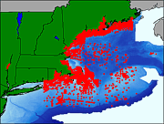
Browse_Graphic:
Browse_Graphic_File_Name:
Browse_Graphic_File_Description:
Thumbnail image showing extent and distribution of data layer coverage.
Browse_Graphic_File_Type: GIF
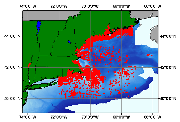
Browse_Graphic:
Browse_Graphic_File_Name:
Browse_Graphic_File_Description:
Image map showing extent and distribution of data layer coverage.
Browse_Graphic_File_Type: GIF
Data_Set_Credit:
National Geophysical Data Center for supplying the original National Ocean Service Hydrographic Database. Larry Poppe for creating the ArcView shapefile.
Native_Data_Set_Environment:
Microsoft Windows XP Version 5.1 (Build 2600) Service Pack 2; ESRI ArcCatalog 9.2.2.1350
Cross_Reference:
Citation_Information:
Originator: National Ocean Service
Originator: National Geophysical Data Center
Publication_Date: Unpublished Material
Title: NOS Hydrographic Database
Edition: 1.0