Data from Oceanographer, Lydonia, and Gilbert Canyons acquired in 1965 (SCHWARTZ65 shapefile)

Metadata also available as - [Questions & Answers] - [Parseable text] - [XML]

Metadata:

Identification_Information:
Citation:
Citation_Information:
Originator: Lawrence J. Poppe
Publication_Date: 2003
Title:
Data from Oceanographer, Lydonia, and Gilbert Canyons acquired in 1965 (SCHWARTZ65 shapefile)
Edition: 1.0
Geospatial_Data_Presentation_Form: vector digital data
Series_Information:
Series_Name: Open-File Report
Issue_Identification: 03-001
Publication_Information:
Publication_Place: Woods Hole Coastal and Marine Science Center, Woods Hole, MA
Publisher: U. S. Geological Survey, Coastal and Marine Geology Program
Online_Linkage: https://doi.org/10.3133/ofr031
Online_Linkage: Online_Linkage: http://pubs.usgs.gov/of/2003/of03-001/htmldocs/data.htm
Larger_Work_Citation:
Citation_Information:
Originator: L.J. Poppe
Originator: V.F. Paskevich
Originator: S.J. Williams
Originator: M.E. Hastings
Originator: J.T. Kelley
Originator: D.F. Belknap
Originator: L.G. Ward
Originator: D.M. Fitzgerald
Originator: P.F. Larsen
Publication_Date: 2003
Title:
Surficial Sediment Data from the Gulf of Maine, Georges Bank, and vicinity: a GIS Compilation
Edition: 1.0
Series_Information:
Series_Name: Open-File Report
Issue_Identification: 03-001
Publication_Information:
Publication_Place: Reston, VA
Publisher: U. S. Geological Survey
Other_Citation_Details: 1 CD-ROM
Online_Linkage: http://pubs.usgs.gov/of/2003/of03-001/
Description:
Abstract:
Submarine canyons occur at the edge of the continental shelf and cut across the slope and rise along the U.S. east coast. Three of these canyons (Oceanographer, Lydonia, and Gilbert) are situated south of Georges Bank. Gravity cores and grab samples were collected as part of a study of the active processes and sediment distributions within these features. The results of the textural analyses are contained in this data layer.
Purpose:
The purpose of this data layer is to provide a digital version of the sediment data published in Schwartz (1965).
Time_Period_of_Content:
Time_Period_Information:
Single_Date/Time:
Calendar_Date: 1965
Currentness_Reference: publication date
Status:
Progress: Complete
Maintenance_and_Update_Frequency: None planned
Spatial_Domain:
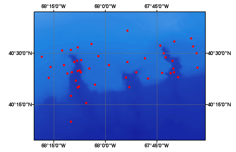
Bounding_Coordinates:
West_Bounding_Coordinate: -68.308000
East_Bounding_Coordinate: -67.553000
North_Bounding_Coordinate: 40.610000
South_Bounding_Coordinate: 40.167000
Keywords:
Theme:
Theme_Keyword_Thesaurus: USGS Metadata Identifier
Theme_Keyword: USGS:de36e72e-adfa-4f94-8bdf-34b110b645fb
Theme:
Theme_Keyword_Thesaurus: None
Theme_Keyword: U.S. Geological Survey
Theme_Keyword: USGS
Theme_Keyword: Woods Hole Science Center
Theme_Keyword: WHSC
Theme_Keyword: Coastal and Marine Geology Program
Theme_Keyword: CMGP
Theme_Keyword: sediment
Theme_Keyword: texture
Theme_Keyword: grain size
Theme_Keyword: cores
Theme_Keyword: grabs
Theme_Keyword: gravel
Theme_Keyword: sand
Theme_Keyword: silt
Theme_Keyword: clay
Theme_Keyword: Open-File Report 03-001
Theme_Keyword: sediment classification
Theme_Keyword: surficial classification
Theme_Keyword: point shapefile
Theme_Keyword: points
Theme_Keyword: GIS
Theme:
Theme_Keyword_Thesaurus: ISO 19115 Topic Category
Theme_Keyword: oceans
Theme_Keyword: location
Theme_Keyword: geoscientificInformation
Theme:
Theme_Keyword_Thesaurus: USGS Thesaurus
Theme_Keyword: grain-size analysis
Theme_Keyword: navigational data
Theme_Keyword: geospatial datasets
Theme_Keyword: sea-floor characteristics
Theme_Keyword: marine geology
Place:
Place_Keyword_Thesaurus: None
Place_Keyword: Georges Bank
Place_Keyword: Oceanographer Canyon
Place_Keyword: Lydonia Canyon
Place_Keyword: Gilbert Canyon
Place_Keyword: U.S. East Coast
Place_Keyword: Atlantic Ocean
Access_Constraints: None
Use_Constraints:
Public domain data from the U.S. Government are freely redistributable with proper metadata and source attribution. Please recognize the U.S. Geological Survey (USGS) as the source of this information.
Point_of_Contact:
Contact_Information:
Contact_Person_Primary:
Contact_Person: Lawrence J. Poppe
Contact_Organization: U.S. Geological Survey
Contact_Position: Geologist
Contact_Address:
Address_Type: mailing and physical address
Address: 384 Woods Hole Road
City: Woods Hole
State_or_Province: MA
Postal_Code: 02543-1598
Country: USA
Contact_Voice_Telephone: (508) 548-8700 x2314
Contact_Facsimile_Telephone: (508) 457-2310
Contact_Electronic_Mail_Address: lpoppe@usgs.gov
Browse_Graphic:
Browse_Graphic_File_Name: Browse_Graphic_File_Description:
Thumbnail image showing extent and distribution of data layer coverage.
Browse_Graphic_File_Type: GIF
Browse_Graphic:
Browse_Graphic_File_Name: Browse_Graphic_File_Description:
Image map showing extent and distribution of data layer coverage.
Browse_Graphic_File_Type: GIF
Data_Set_Credit:
Please review the cross reference information for the original data set credit to J.Schwartz. Larry Poppe for creating the ArcView shapefile.
Native_Data_Set_Environment:
Microsoft Windows XP Version 5.1 (Build 2600) Service Pack 2; ESRI ArcCatalog 9.2.2.1350
Cross_Reference:
Citation_Information:
Originator: James Schwartz
Publication_Date: 1965
Title:
The Geology of Oceanographer, Gilbert, and Lydonia Submarine Canyons South of Georges Bank, off the Northeastern U.S.
Edition: 1.0
Publication_Information:
Publication_Place: Kingston, RI
Publisher: University of Rhode Island
Other_Citation_Details: Master's Thesis
Data_Quality_Information:
Attribute_Accuracy:
Attribute_Accuracy_Report:
All attributes were checked by the compilers in a consistent manner.
Logical_Consistency_Report:
No additional checks for topological consistency were performed on these data.
Completeness_Report:
Grain-size data, textural descriptions, navigation, and identifiers are provided for 50 stations.
Positional_Accuracy:
Horizontal_Positional_Accuracy:
Horizontal_Positional_Accuracy_Report:
Navigation was by Loran A. Inasmuch as the shore locations were not reported and the accuracy of Loran A is dependent on the distance from the stations, accuracy of the navigation is unknown.
Lineage:
Source_Information:
Source_Citation:
Citation_Information:
Originator: James Schwartz
Publication_Date: 1965
Title:
The geology of Oceanographer, Gilbert, and Lydonia submarine canyons south of Georges Bank, off the northeastern U.S.
Edition: 1.0
Publication_Information:
Publication_Place: Kingston, RI
Publisher: University of Rhode Island
Other_Citation_Details: Master's Thesis
Type_of_Source_Media: paper
Source_Time_Period_of_Content:
Time_Period_Information:
Single_Date/Time:
Calendar_Date: 1965
Source_Currentness_Reference: publication date
Source_Citation_Abbreviation: Information unavailable from original metadata.
Source_Contribution: Information unavailable from original metadata.
Process_Step:
Process_Description:
The data were obtained from the National Geophysical Data Center and imported from an ASCII text file to an ArcView table. The table was later converted to an event theme in ArcView and saved as the final shapefile.
Source_Used_Citation_Abbreviation: schwartz65.txt
Process_Date: 20020912
Source_Produced_Citation_Abbreviation: schwartz65.shp
Source_Produced_Citation_Abbreviation: schwartz65.dbf
Source_Produced_Citation_Abbreviation: schwartz65.shx
Process_Contact:
Contact_Information:
Contact_Person_Primary:
Contact_Person: Lawrence J. Poppe
Contact_Organization: U.S. Geological Survey
Contact_Position: Geologist
Contact_Address:
Address_Type: mailing and physical address
Address: 384 Woods Hole Road
City: Woods Hole
State_or_Province: MA
Postal_Code: 02543-1598
Country: USA
Contact_Voice_Telephone: (508) 548-8700 x2314
Contact_Facsimile_Telephone: (508) 457-2310
Contact_Electronic_Mail_Address: lpoppe@usgs.gov
Process_Step:
Process_Description:
Edits to the metadata were made to fix any errors that MP v 2.9.32 flagged. This is necessary to enable the metadata to be successfully harvested for various data catalogs. In some cases, this meant adding text "Information unavailable" or "Information unavailable from original metadata" for those required fields that were left blank. Other minor edits were probably performed (title, publisher, publication place, etc.). The metadata date (but not the metadata creator) was edited to reflect the date of these changes. The metadata available from a harvester may supersede metadata bundled within a download file. Compare the metadata dates to determine which metadata file is most recent.
Process_Date: 20151202
Process_Contact:
Contact_Information:
Contact_Organization_Primary:
Contact_Organization: U.S. Geological Survey
Contact_Person: VeeAnn A. Cross
Contact_Position: Marine Geologist
Contact_Address:
Address_Type: mailing and physical address
Address: 384 Woods Hole Rd.
City: Woods Hole
State_or_Province: MA
Postal_Code: 02543
Contact_Voice_Telephone: 508-548-8700 x2251
Contact_Facsimile_Telephone: 508-457-2310
Contact_Electronic_Mail_Address: vatnipp@usgs.gov
Process_Step:
Process_Description: USGS Thesaurus keywords added to the keyword section.
Process_Date: 20180720
Process_Contact:
Contact_Information:
Contact_Organization_Primary:
Contact_Organization: U.S. Geological Survey
Contact_Person: VeeAnn A. Cross
Contact_Position: Marine Geologist
Contact_Address:
Address_Type: Mailing and Physical
Address: 384 Woods Hole Road
City: Woods Hole
State_or_Province: MA
Postal_Code: 02543-1598
Contact_Voice_Telephone: 508-548-8700 x2251
Contact_Facsimile_Telephone: 508-457-2310
Contact_Electronic_Mail_Address: vatnipp@usgs.gov
Process_Step:
Process_Description: Crossref DOI link was added as the first link in the metadata.
Process_Date: 20191118
Process_Contact:
Contact_Information:
Contact_Organization_Primary:
Contact_Organization: U.S. Geological Survey
Contact_Person: VeeAnn A. Cross
Contact_Position: Marine Geologist
Contact_Address:
Address_Type: Mailing and Physical
Address: 384 Woods Hole Road
City: Woods Hole
State_or_Province: MA
Postal_Code: 02543-1598
Contact_Voice_Telephone: 508-548-8700 x2251
Contact_Facsimile_Telephone: 508-457-2310
Contact_Electronic_Mail_Address: vatnipp@usgs.gov
Process_Step:
Process_Description:
Added keywords section with USGS persistent identifier as theme keyword.
Process_Date: 20200908
Process_Contact:
Contact_Information:
Contact_Organization_Primary:
Contact_Organization: U.S. Geological Survey
Contact_Person: VeeAnn A. Cross
Contact_Position: Marine Geologist
Contact_Address:
Address_Type: Mailing and Physical
Address: 384 Woods Hole Road
City: Woods Hole
State_or_Province: MA
Postal_Code: 02543-1598
Contact_Voice_Telephone: 508-548-8700 x2251
Contact_Facsimile_Telephone: 508-457-2310
Contact_Electronic_Mail_Address: vatnipp@usgs.gov
Spatial_Data_Organization_Information:
Direct_Spatial_Reference_Method: Vector
Point_and_Vector_Object_Information:
SDTS_Terms_Description:
SDTS_Point_and_Vector_Object_Type: Entity point
Point_and_Vector_Object_Count: 50
Spatial_Reference_Information:
Horizontal_Coordinate_System_Definition:
Geographic:
Latitude_Resolution: 0.001
Longitude_Resolution: 0.001
Geographic_Coordinate_Units: Decimal degrees
Geodetic_Model:
Horizontal_Datum_Name: North American Datum of 1927
Ellipsoid_Name: Clarke 1866
Semi-major_Axis: 6378206.400000
Denominator_of_Flattening_Ratio: 294.978698
Entity_and_Attribute_Information:
Detailed_Description:
Entity_Type:
Entity_Type_Label: schwartz65.dbf
Entity_Type_Definition: Shapefile Attribute Table
Entity_Type_Definition_Source: ESRI
Attribute:
Attribute_Label: FID
Attribute_Definition: Internal feature number.
Attribute_Definition_Source: ESRI
Attribute_Domain_Values:
Unrepresentable_Domain:
Sequential unique whole numbers that are automatically generated.
Attribute:
Attribute_Label: Shape
Attribute_Definition: Feature geometry.
Attribute_Definition_Source: ESRI
Attribute_Domain_Values:
Unrepresentable_Domain: Coordinates defining the features.
Attribute:
Attribute_Label: CONSECNO
Attribute_Definition: Sequential number assigned to a data record
Attribute_Definition_Source: Compiler
Attribute_Domain_Values:
Range_Domain:
Range_Domain_Minimum: 1
Range_Domain_Maximum: 50
Attribute_Units_of_Measure: station
Attribute_Measurement_Resolution: 1
Attribute:
Attribute_Label: PROJECTID
Attribute_Definition: Name assigned to the data set for future identification
Attribute_Definition_Source: Compiler
Attribute_Domain_Values:
Enumerated_Domain:
Enumerated_Domain_Value: SCHWARTZ65
Enumerated_Domain_Value_Definition: Scientist and publication year
Enumerated_Domain_Value_Definition_Source: Compiler
Attribute:
Attribute_Label: CRUISEID
Attribute_Definition: Cruise identifier
Attribute_Definition_Source: Scientist
Attribute_Domain_Values:
Enumerated_Domain:
Enumerated_Domain_Value: TR-018
Enumerated_Domain_Value_Definition: Abbreviated name of ship (Trident) and cruise number
Enumerated_Domain_Value_Definition_Source: Scientist
Attribute:
Attribute_Label: STATION
Attribute_Definition: Unique identifier assigned to the sampling sites
Attribute_Definition_Source: Scientist
Attribute_Domain_Values:
Unrepresentable_Domain: Numbers and characters designating the stations
Attribute:
Attribute_Label: DEVICE
Attribute_Definition: Equipment used to collect samples
Attribute_Definition_Source: Scientist
Attribute_Domain_Values:
Unrepresentable_Domain: Van Veen Grab and Gravity Core
Attribute:
Attribute_Label: DATE
Attribute_Definition: Date when samples were collected
Attribute_Definition_Source: Scientist
Attribute_Domain_Values:
Enumerated_Domain:
Enumerated_Domain_Value: 196407
Enumerated_Domain_Value_Definition: Year and month
Enumerated_Domain_Value_Definition_Source: Scientist
Attribute:
Attribute_Label: LATITUDE
Attribute_Definition: Latitude coordinate of sample location
Attribute_Definition_Source: Scientist
Attribute_Domain_Values:
Range_Domain:
Range_Domain_Minimum: 40.167
Range_Domain_Maximum: 40.610
Attribute_Units_of_Measure: decimal degrees
Attribute_Measurement_Resolution: 0.001
Attribute:
Attribute_Label: LONGITUDE
Attribute_Definition: Longitude coordinate of sample location
Attribute_Definition_Source: Scientist
Attribute_Domain_Values:
Range_Domain:
Range_Domain_Minimum: -68.308
Range_Domain_Maximum: -67.553
Attribute_Units_of_Measure: decimal degrees
Attribute_Measurement_Resolution: 0.001
Attribute:
Attribute_Label: DEPTH
Attribute_Definition: Water depth
Attribute_Definition_Source: Scientist
Attribute_Domain_Values:
Range_Domain:
Range_Domain_Minimum: 95
Range_Domain_Maximum: 1700
Attribute_Units_of_Measure: meters
Attribute_Measurement_Resolution: 1
Attribute:
Attribute_Label: DOMINANT_L
Attribute_Definition: Primary lithology
Attribute_Definition_Source: Scientist
Attribute_Domain_Values:
Unrepresentable_Domain: Major lithologic component of the sediment
Attribute:
Attribute_Label: SECOND_LIT
Attribute_Definition: Secondary lithologic component of the sediments
Attribute_Definition_Source: Scientst
Attribute_Domain_Values:
Unrepresentable_Domain: Lithologic component of the sediment
Attribute:
Attribute_Label: GRAVEL
Attribute_Definition: Percentage of gravel in the sample
Attribute_Definition_Source: Scientist
Attribute_Domain_Values:
Range_Domain:
Range_Domain_Minimum: 0
Range_Domain_Maximum: 72.7
Attribute_Units_of_Measure: percent
Attribute_Measurement_Resolution: 0.1
Attribute:
Attribute_Label: SAND
Attribute_Definition: Percentage of sand in the sample
Attribute_Definition_Source: Scientist
Attribute_Domain_Values:
Range_Domain:
Range_Domain_Minimum: 0
Range_Domain_Maximum: 99.4
Attribute_Units_of_Measure: percent
Attribute_Measurement_Resolution: 0.1
Attribute:
Attribute_Label: SILT
Attribute_Definition: Percentage of silt in sample
Attribute_Definition_Source: Scientist
Attribute_Domain_Values:
Range_Domain:
Range_Domain_Minimum: 0
Range_Domain_Maximum: 64.9
Attribute_Units_of_Measure: percent
Attribute_Measurement_Resolution: 0.1
Attribute:
Attribute_Label: CLAY
Attribute_Definition: Percentage of clay in sample
Attribute_Definition_Source: Scientist
Attribute_Domain_Values:
Range_Domain:
Range_Domain_Minimum: 0
Range_Domain_Maximum: 46.9
Attribute_Units_of_Measure: percent
Attribute_Measurement_Resolution: 0.1
Attribute:
Attribute_Label: SHEPARD_CL
Attribute_Definition:
Textural classification based on a scheme devised by Shepard (1954)
Attribute_Definition_Source: Compiler
Attribute_Domain_Values:
Unrepresentable_Domain: Textural Classification
Overview_Description:
Entity_and_Attribute_Overview:
Grain-size data, textural descriptions, lithologic descriptions, navigation, and cruise, project, and sample identifiers.
Entity_and_Attribute_Detail_Citation: U.S. Geological Survey
Distribution_Information:
Distributor:
Contact_Information:
Contact_Person_Primary:
Contact_Person: Lawrence J. Poppe
Contact_Organization: U.S. Geological Survey
Contact_Position: Geologist
Contact_Address:
Address_Type: mailing and physical address
Address: 384 Woods Hole Road
City: Woods Hole
State_or_Province: MA
Postal_Code: 02543-1598
Country: USA
Contact_Voice_Telephone: (508) 548-8700 x2314
Contact_Facsimile_Telephone: (508) 457-2310
Contact_Electronic_Mail_Address: lpoppe@usgs.gov
Resource_Description: Downloadable Data
Distribution_Liability:
Although these data have been used by the U.S. Geological Survey (USGS), U.S. Department of the Interior (DOI), no warranty expressed or implied is made by the U.S. Geological Survey as to the accuracy of the data. The act of distribution shall not constitute any such warranty, and no responsibility is assumed by the USGS in the use of these data or related materials. Any use of trade, product, or firm names is for descriptive purposes only and does not imply endorsement by the U.S. Government.
Standard_Order_Process:
Digital_Form:
Digital_Transfer_Information:
Format_Name: SHP
Format_Version_Number: 3.2
Format_Specification: ESRI point shapefile
Format_Information_Content:
Five files (schwartz65.shp, schwartz65.dbf, schwartz65.shx, schwartz65.sbx, schwartz65.sbn) comprising the ArcView point shapefile components, 'prj' and 'avl' files, metadata text file and browse graphic.
File_Decompression_Technique: zip
Transfer_Size: 0.05
Digital_Transfer_Option:
Online_Option:
Computer_Contact_Information: Access_Instructions: Data may be downloaded via the World Wide Web (WWW).
Offline_Option:
Offline_Media: CD-ROM
Recording_Capacity:
Recording_Density: 650
Recording_Density_Units: Mbytes
Recording_Format: ISO 9660
Compatibility_Information:
The user must have a computer system with a CD-ROM available. To browse the information contained on this CD-ROM, the user must have a current WWW browser available. The user must also have software installed on their computer to unzip the archived file.
Fees: None
Technical_Prerequisites:
These data are available in Environmental Systems Research Institute (ESRI) shapefile format. The user must have ArcGIS or ArcView 3.0 or greater software to read and process the data file. In lieu of ArcView or ArcGIS, the user may utilize another GIS application package capable of importing the data. A free data viewer, ArcExplorer, capable of displaying the data is available from ESRI at www.esri.com.
Available_Time_Period:
Time_Period_Information:
Single_Date/Time:
Calendar_Date: 2002
Metadata_Reference_Information:
Metadata_Date: 20211116
Metadata_Contact:
Contact_Information:
Contact_Person_Primary:
Contact_Person: Lawrence J. Poppe
Contact_Organization: U.S. Geological Survey
Contact_Position: Geologist
Contact_Address:
Address_Type: mailing and physical address
Address: 384 Woods Hole Road
City: Woods Hole
State_or_Province: MA
Postal_Code: 02543-1598
Country: USA
Contact_Voice_Telephone: (508) 548-8700 x2314
Contact_Facsimile_Telephone: (508) 457-2310
Contact_Electronic_Mail_Address: whsc_data_contact@usgs.gov
Contact_Instructions:
The metadata contact email address is a generic address in the event the metadata contact is no longer with the USGS or the email is otherwise invalid.
Metadata_Standard_Name: FGDC Content Standards for Digital Geospatial Metadata
Metadata_Standard_Version: FGDC-STD-001-1998
Metadata_Time_Convention: local time
Metadata_Access_Constraints: None
Metadata_Use_Constraints: None

This page is <https://cmgds.marine.usgs.gov/catalog/whcmsc/open_file_report/ofr2003-001/schwartz65.shp.html>
Generated by mp version 2.9.50 on Tue Nov 16 10:06:29 2021