Samples collected along transects off the Eastern United States in 1938 (STETSON38 shapefile)

Metadata also available as - [Questions & Answers] - [Parseable text] - [XML]

Metadata:

Identification_Information:
Citation:
Citation_Information:
Originator: Lawrence J. Poppe
Publication_Date: 2003
Title:
Samples collected along transects off the Eastern United States in 1938 (STETSON38 shapefile)
Edition: 1.0
Geospatial_Data_Presentation_Form: vector digital data
Series_Information:
Series_Name: Open-File Report
Issue_Identification: 03-001
Publication_Information:
Publication_Place: Woods Hole Coastal and Marine Science Center, Woods Hole, MA
Publisher: U.S. Geological Survey, Coastal and Marine Geology Program
Online_Linkage: https://doi.org/10.3133/ofr031
Online_Linkage: Online_Linkage: http://pubs.usgs.gov/of/2003/of03-001/htmldocs/data.htm
Larger_Work_Citation:
Citation_Information:
Originator: L.J. Poppe
Originator: V.F. Paskevich
Originator: S.J. Williams
Originator: M.E. Hastings
Originator: J.T. Kelley
Originator: D.F. Belknap
Originator: L.G. Ward
Originator: D.M. Fitzgerald
Originator: P.F. Larsen
Publication_Date: 2003
Title:
Surficial Sediment Data from the Gulf of Maine, Georges Bank, and vicinity: a GIS Compilation
Edition: 1.0
Series_Information:
Series_Name: Open-File Report
Issue_Identification: 03-001
Publication_Information:
Publication_Place: Reston, VA
Publisher: U. S. Geological Survey
Other_Citation_Details: 1 CD-ROM
Online_Linkage: http://pubs.usgs.gov/of/2003/of03-001/
Description:
Abstract:
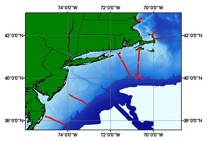
This study was undertaken to provide information on the characteristics and distribution of surficial sediments off the eastern United States. Accordingly, long traverses were run across the continental shelf and in most case carrying over the shelf break. This data set includes data from those 9 traverses which were conducted north of Virginia. These data constitute the first systematic sampling of the U.S. Atlantic margin to show the effects of environmental factors (e.g. increasing distance from shore, water depth) on the sediment distribution. Sampling was performed with a primitive grab sampler; navigational methods were not discussed in this report.
Purpose:
The purpose of this data layer is to release a digital version of the textural data generated from sediments collected as part of Stetson's research during the 1930's. This digital version comprises part of a USGS sand and gravel assessment of the NY Bight, Gulf of Maine, and Georges Bank.
Time_Period_of_Content:
Time_Period_Information:
Single_Date/Time:
Calendar_Date: 1938
Currentness_Reference: publication date
Status:
Progress: Complete
Maintenance_and_Update_Frequency: None planned
Spatial_Domain:
Bounding_Coordinates:
West_Bounding_Coordinate: -75.033330
East_Bounding_Coordinate: -69.636670
North_Bounding_Coordinate: 42.811170
South_Bounding_Coordinate: 37.816670
Keywords:
Theme:
Theme_Keyword_Thesaurus: USGS Metadata Identifier
Theme_Keyword: USGS:eb3f58b7-23f6-48d4-8c6d-45bd01368cc3
Theme:
Theme_Keyword_Thesaurus: None
Theme_Keyword: U.S. Geological Survey
Theme_Keyword: USGS
Theme_Keyword: Coastal and Marine Geology Program
Theme_Keyword: CMGP
Theme_Keyword: Woods Hole Science Center
Theme_Keyword: WHSC
Theme_Keyword: grabs
Theme_Keyword: locations
Theme_Keyword: point shapefile
Theme_Keyword: MIT
Theme_Keyword: Woods Hole Oceanographic Institution
Theme_Keyword: sediments
Theme_Keyword: size analyses
Theme_Keyword: grain size
Theme_Keyword: gravel
Theme_Keyword: sand
Theme_Keyword: silt
Theme_Keyword: clay
Theme_Keyword: Geographic Information System
Theme_Keyword: GIS
Theme_Keyword: National Assessment of Marine Sand and Gravel Resources
Theme_Keyword: Open-File Report 03-001
Theme_Keyword: sediment classification
Theme_Keyword: surficial classification
Theme_Keyword: point shapefile
Theme_Keyword: points
Theme:
Theme_Keyword_Thesaurus: ISO 19115 Topic Category
Theme_Keyword: oceans
Theme_Keyword: location
Theme_Keyword: geoscientificInformation
Theme:
Theme_Keyword_Thesaurus: USGS Thesaurus
Theme_Keyword: grain-size analysis
Theme_Keyword: navigational data
Theme_Keyword: geospatial datasets
Theme_Keyword: sea-floor characteristics
Theme_Keyword: marine geology
Place:
Place_Keyword_Thesaurus: None
Place_Keyword: U.S. Eastcoast
Place_Keyword: NY Bight
Place_Keyword: New York Bight
Place_Keyword: New England
Place_Keyword: Atlantic
Place_Keyword: Continental Shelf
Access_Constraints: None
Use_Constraints:
Public domain data from the U.S. Government are freely redistributable with proper metadata and source attribution. Please recognize the U.S. Geological Survey (USGS) as the source of this information.
Point_of_Contact:
Contact_Information:
Contact_Person_Primary:
Contact_Person: Lawrence J. Poppe
Contact_Organization: U.S. Geological Survey
Contact_Position: Geologist
Contact_Address:
Address_Type: mailing and physical address
Address: 384 Woods Hole Road
City: Woods Hole
State_or_Province: MA
Postal_Code: 02543-1598
Country: USA
Contact_Voice_Telephone: (508) 548-8700 x2314
Contact_Facsimile_Telephone: (508) 457-2310
Contact_Electronic_Mail_Address: lpoppe@usgs.gov
Browse_Graphic:
Browse_Graphic_File_Name: Browse_Graphic_File_Description:
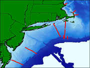
Thumbnail image showing extent and distribution of data layer coverage.
Browse_Graphic_File_Type: GIF
Browse_Graphic:
Browse_Graphic_File_Name: Browse_Graphic_File_Description:
Image map showing extent and distribution of data layer coverage.
Browse_Graphic_File_Type: GIF
Data_Set_Credit:
Please view the cross reference information for the original data set credit to H.C. Stetson. Larry Poppe for entering the data from the source report and creating the ArcView shapefile.
Native_Data_Set_Environment:
Microsoft Windows XP Version 5.1 (Build 2600) Service Pack 2; ESRI ArcCatalog 9.2.2.1350
Cross_Reference:
Citation_Information:
Originator: H.C. Stetson
Publication_Date: 1938
Title:
The sediments of the continental shelf off the eastern coast of the United States
Edition: 1
Series_Information:
Series_Name: Papers in Physical Oceanography and Meteorology
Issue_Identification: v.4, no. 5
Publication_Information:
Publication_Place: Cambridge and Woods Hole
Publisher: MIT and WHOI
Data_Quality_Information:
Attribute_Accuracy:
Attribute_Accuracy_Report:
All attributes were entered and checked by the compilers in a consistent manner.
Logical_Consistency_Report:
No additional checks for topological consistency were performed on this data.
Completeness_Report:
Sample locations, grain-size data, and verbal classifications are provided for 225 stations.
Positional_Accuracy:
Horizontal_Positional_Accuracy:
Horizontal_Positional_Accuracy_Report:
No navigational methods are provided in the original publication. Horizontal accuracy is unknown.
Vertical_Positional_Accuracy:
Vertical_Positional_Accuracy_Report: Tides are less than 2 m.
Quantitative_Vertical_Positional_Accuracy_Assessment:
Vertical_Positional_Accuracy_Value: 2
Vertical_Positional_Accuracy_Explanation: Information unavailable from original metadata.
Lineage:
Source_Information:
Source_Citation:
Citation_Information:
Originator: H.C. Stetson
Publication_Date: 1938
Title:
The sediments of the continental shelf off the eastern coast of the United States
Edition: 1.0
Series_Information:
Series_Name: Papers in Physical Oceanography and Meteorology
Issue_Identification: v. 5, no. 4
Publication_Information:
Publication_Place: Cambridge and Woods Hole
Publisher: MIT and WHOI
Type_of_Source_Media: paper
Source_Time_Period_of_Content:
Time_Period_Information:
Single_Date/Time:
Calendar_Date: 1938
Source_Currentness_Reference: publication date
Source_Citation_Abbreviation: stetson.txt
Source_Contribution:
Summarized tabular data from the report were converted to an ASCII text file.
Process_Step:
Process_Description:
The source information was manually entered into digital form and was imported from an ASCII text file to an ArcView table. The table was later converted to an event theme in ArcView and saved as the final shapefile.
Source_Used_Citation_Abbreviation: stetson.txt
Process_Date: 20020828
Source_Produced_Citation_Abbreviation: stetson38.shp
Source_Produced_Citation_Abbreviation: stetson38.dbf
Source_Produced_Citation_Abbreviation: stetson38.shx
Process_Contact:
Contact_Information:
Contact_Person_Primary:
Contact_Person: Lawrence J. Poppe
Contact_Organization: U.S. Geological Survey
Contact_Position: Geologist
Contact_Address:
Address_Type: mailing and physical address
Address: 384 Woods Hole Road
City: Woods Hole
State_or_Province: MA
Postal_Code: 02543-1598
Country: USA
Contact_Voice_Telephone: (508) 548-8700 x2314
Contact_Facsimile_Telephone: (508) 457-2310
Contact_Electronic_Mail_Address: lpoppe@usgs.gov
Process_Step:
Process_Description:
Edits to the metadata were made to fix any errors that MP v 2.9.32 flagged. This is necessary to enable the metadata to be successfully harvested for various data catalogs. In some cases, this meant adding text "Information unavailable" or "Information unavailable from original metadata" for those required fields that were left blank. Other minor edits were probably performed (title, publisher, publication place, etc.). Minor fixes to the attribute format for some attributes was needed. The metadata date (but not the metadata creator) was edited to reflect the date of these changes. The metadata available from a harvester may supersede metadata bundled within a download file. Compare the metadata dates to determine which metadata file is most recent.
Process_Date: 20151202
Process_Contact:
Contact_Information:
Contact_Organization_Primary:
Contact_Organization: U.S. Geological Survey
Contact_Person: VeeAnn A. Cross
Contact_Position: Marine Geologist
Contact_Address:
Address_Type: mailing and physical address
Address: 384 Woods Hole Rd.
City: Woods Hole
State_or_Province: MA
Postal_Code: 02543
Contact_Voice_Telephone: 508-548-8700 x2251
Contact_Facsimile_Telephone: 508-457-2310
Contact_Electronic_Mail_Address: vatnipp@usgs.gov
Process_Step:
Process_Description: USGS Thesaurus keywords added to the keyword section.
Process_Date: 20180720
Process_Contact:
Contact_Information:
Contact_Organization_Primary:
Contact_Organization: U.S. Geological Survey
Contact_Person: VeeAnn A. Cross
Contact_Position: Marine Geologist
Contact_Address:
Address_Type: Mailing and Physical
Address: 384 Woods Hole Road
City: Woods Hole
State_or_Province: MA
Postal_Code: 02543-1598
Contact_Voice_Telephone: 508-548-8700 x2251
Contact_Facsimile_Telephone: 508-457-2310
Contact_Electronic_Mail_Address: vatnipp@usgs.gov
Process_Step:
Process_Description: Crossref DOI link was added as the first link in the metadata.
Process_Date: 20191118
Process_Contact:
Contact_Information:
Contact_Organization_Primary:
Contact_Organization: U.S. Geological Survey
Contact_Person: VeeAnn A. Cross
Contact_Position: Marine Geologist
Contact_Address:
Address_Type: Mailing and Physical
Address: 384 Woods Hole Road
City: Woods Hole
State_or_Province: MA
Postal_Code: 02543-1598
Contact_Voice_Telephone: 508-548-8700 x2251
Contact_Facsimile_Telephone: 508-457-2310
Contact_Electronic_Mail_Address: vatnipp@usgs.gov
Process_Step:
Process_Description:
Added keywords section with USGS persistent identifier as theme keyword.
Process_Date: 20200908
Process_Contact:
Contact_Information:
Contact_Organization_Primary:
Contact_Organization: U.S. Geological Survey
Contact_Person: VeeAnn A. Cross
Contact_Position: Marine Geologist
Contact_Address:
Address_Type: Mailing and Physical
Address: 384 Woods Hole Road
City: Woods Hole
State_or_Province: MA
Postal_Code: 02543-1598
Contact_Voice_Telephone: 508-548-8700 x2251
Contact_Facsimile_Telephone: 508-457-2310
Contact_Electronic_Mail_Address: vatnipp@usgs.gov
Spatial_Data_Organization_Information:
Direct_Spatial_Reference_Method: Vector
Point_and_Vector_Object_Information:
SDTS_Terms_Description:
SDTS_Point_and_Vector_Object_Type: Entity point
Point_and_Vector_Object_Count: 225
Spatial_Reference_Information:
Horizontal_Coordinate_System_Definition:
Geographic:
Latitude_Resolution: 0.00001
Longitude_Resolution: 0.00001
Geographic_Coordinate_Units: Decimal degrees
Geodetic_Model:
Horizontal_Datum_Name: North American Datum of 1927
Ellipsoid_Name: Clarke 1866
Semi-major_Axis: 6378206.400000
Denominator_of_Flattening_Ratio: 294.978698
Entity_and_Attribute_Information:
Detailed_Description:
Entity_Type:
Entity_Type_Label: stetson.dbf
Entity_Type_Definition: Shapefile Attribute Table
Entity_Type_Definition_Source: ESRI
Attribute:
Attribute_Label: FID
Attribute_Definition: Internal feature number.
Attribute_Definition_Source: ESRI
Attribute_Domain_Values:
Unrepresentable_Domain:
Sequential unique whole numbers that are automatically generated.
Attribute:
Attribute_Label: Shape
Attribute_Definition: Feature geometry.
Attribute_Definition_Source: ESRI
Attribute_Domain_Values:
Unrepresentable_Domain: Coordinates defining the features.
Attribute:
Attribute_Label: PROJECT_ID
Attribute_Definition: Project id assigned to the dataset for future identification.
Attribute_Definition_Source: Compiler
Attribute_Domain_Values:
Enumerated_Domain:
Enumerated_Domain_Value: STETSON1938
Enumerated_Domain_Value_Definition: Scientist and year of data publication.
Enumerated_Domain_Value_Definition_Source: Compiler
Attribute:
Attribute_Label: SERIES_ID
Attribute_Definition:
Number assigned to a transect along which samples were collected.
Attribute_Definition_Source: H.C. Stetson
Attribute_Domain_Values:
Range_Domain:
Range_Domain_Minimum: 1
Range_Domain_Maximum: 9
Attribute_Units_of_Measure: integer count
Attribute_Measurement_Resolution: 1
Attribute_Value_Accuracy_Information:
Attribute_Value_Accuracy: 1
Attribute_Value_Accuracy_Explanation: Information unavailable from original metadata.
Attribute:
Attribute_Label: SAMPLE_ID
Attribute_Definition: Number assigned sequentially to each sample along a transect.
Attribute_Definition_Source: H.C. Stetson
Attribute_Domain_Values:
Unrepresentable_Domain:
Character string containing numeric identifier and sub-identifier
Attribute_Value_Accuracy_Information:
Attribute_Value_Accuracy: 1
Attribute_Value_Accuracy_Explanation: Information unavailable from original metadata.
Attribute:
Attribute_Label: LATITUDE
Attribute_Definition: Latitude coordinate of sample location
Attribute_Definition_Source: Scientist
Attribute_Domain_Values:
Range_Domain:
Range_Domain_Minimum: 37.81667
Range_Domain_Maximum: 42.81117
Attribute_Units_of_Measure: decimal degrees
Attribute_Measurement_Resolution: .00001
Attribute:
Attribute_Label: LONGITUDE
Attribute_Definition: Longitude of sample location
Attribute_Definition_Source: Scientist
Attribute_Domain_Values:
Range_Domain:
Range_Domain_Minimum: -75.03337
Range_Domain_Maximum: -69.63667
Attribute_Units_of_Measure: decimal degrees
Attribute_Measurement_Resolution: .00001
Attribute:
Attribute_Label: DEPTH
Attribute_Definition: Water depth in meters at sample location.
Attribute_Definition_Source: Scientist
Attribute_Domain_Values:
Range_Domain:
Range_Domain_Minimum: 5.0
Range_Domain_Maximum: 680.0
Attribute_Units_of_Measure: meters
Attribute_Measurement_Resolution: 0.1
Attribute:
Attribute_Label: GRAVEL
Attribute_Definition: Percent gravel in the sample
Attribute_Definition_Source: Scientist
Attribute_Domain_Values:
Range_Domain:
Range_Domain_Minimum: 0.0
Range_Domain_Maximum: 77.0
Attribute_Units_of_Measure: percent
Attribute_Measurement_Resolution: 0.1
Attribute:
Attribute_Label: SAND
Attribute_Definition: Percent sand in the sample.
Attribute_Definition_Source: Scientist
Attribute_Domain_Values:
Range_Domain:
Range_Domain_Minimum: 2.0
Range_Domain_Maximum: 100.0
Attribute_Units_of_Measure: percent
Attribute_Measurement_Resolution: 0.1
Attribute:
Attribute_Label: SILT
Attribute_Definition: Percent of silt in the sample.
Attribute_Definition_Source: Scientist
Attribute_Domain_Values:
Range_Domain:
Range_Domain_Minimum: 0.0
Range_Domain_Maximum: 70.0
Attribute_Units_of_Measure: percent
Attribute_Measurement_Resolution: 0.1
Attribute:
Attribute_Label: CLAYX
Attribute_Definition: Percent of clay fraction coarser than 0.1 micrometers.
Attribute_Definition_Source: Scientist
Attribute_Domain_Values:
Range_Domain:
Range_Domain_Minimum: 0.0
Range_Domain_Maximum: 25.0
Attribute_Units_of_Measure: percent
Attribute_Measurement_Resolution: 0.1
Attribute:
Attribute_Label: COLLOID
Attribute_Definition:
Percent of the clay fraction that is colloidal (less than 0.1 micrometers)
Attribute_Definition_Source: Scientist
Attribute_Domain_Values:
Range_Domain:
Range_Domain_Minimum: 0.0
Range_Domain_Maximum: 26.0
Attribute_Units_of_Measure: percent
Attribute_Measurement_Resolution: 0.1
Attribute:
Attribute_Label: CLAY
Attribute_Definition: Percent of the entire clay fraction.
Attribute_Definition_Source: Scientist
Attribute_Domain_Values:
Range_Domain:
Range_Domain_Minimum: 0.0
Range_Domain_Maximum: 51.0
Attribute_Units_of_Measure: percent
Attribute_Measurement_Resolution: 0.1
Attribute:
Attribute_Label: TOTAL
Attribute_Definition:
Total of the gravel, sand, silt, and clay percentages (used to check that all material was accounted for).
Attribute_Definition_Source: Compiler
Attribute_Domain_Values:
Range_Domain:
Range_Domain_Minimum: 100.0
Range_Domain_Maximum: 100.0
Attribute_Units_of_Measure: percent
Attribute_Measurement_Resolution: 0.1
Attribute:
Attribute_Label: CLASSIFICA
Attribute_Definition:
Sediment classification according to the scheme devised by Shepard (1954)
Attribute_Definition_Source: L.J. Poppe
Attribute_Domain_Values:
Unrepresentable_Domain:
Character string containing the verbal equivalents of the classification scheme.
Attribute_Domain_Values:
Enumerated_Domain:
Enumerated_Domain_Value: CLAYEY SAND
Enumerated_Domain_Value_Definition: clayey sand content
Enumerated_Domain_Value_Definition_Source: Compiler
Attribute_Domain_Values:
Enumerated_Domain:
Enumerated_Domain_Value: CLAYEY SILT
Enumerated_Domain_Value_Definition: clayey silt content
Enumerated_Domain_Value_Definition_Source: Compiler
Attribute_Domain_Values:
Enumerated_Domain:
Enumerated_Domain_Value: GRAVEL
Enumerated_Domain_Value_Definition: gravel content
Enumerated_Domain_Value_Definition_Source: Compiler
Attribute_Domain_Values:
Enumerated_Domain:
Enumerated_Domain_Value: GRAVELLY SEDIMENT
Enumerated_Domain_Value_Definition: gravelly sediment content
Enumerated_Domain_Value_Definition_Source: Compiler
Attribute_Domain_Values:
Enumerated_Domain:
Enumerated_Domain_Value: SAND
Enumerated_Domain_Value_Definition: sand content
Enumerated_Domain_Value_Definition_Source: Compiler
Attribute_Domain_Values:
Enumerated_Domain:
Enumerated_Domain_Value: SAND SILT CLAY
Enumerated_Domain_Value_Definition: sand silt clay content
Enumerated_Domain_Value_Definition_Source: Compiler
Attribute_Domain_Values:
Enumerated_Domain:
Enumerated_Domain_Value: SANDY SILT
Enumerated_Domain_Value_Definition: sandy silt content
Enumerated_Domain_Value_Definition_Source: Compiler
Attribute_Domain_Values:
Enumerated_Domain:
Enumerated_Domain_Value: SILTY CLAY
Enumerated_Domain_Value_Definition: silty clay content
Enumerated_Domain_Value_Definition_Source: Compiler
Attribute_Domain_Values:
Enumerated_Domain:
Enumerated_Domain_Value: SILTY SAND
Enumerated_Domain_Value_Definition: silty sand content
Enumerated_Domain_Value_Definition_Source: Compiler
Distribution_Information:
Distributor:
Contact_Information:
Contact_Person_Primary:
Contact_Person: Lawrence J. Poppe
Contact_Organization: U.S. Geological Survey
Contact_Position: Geologist
Contact_Address:
Address_Type: mailing and physical address
Address: 384 Woods Hole Road
City: Woods Hole
State_or_Province: MA
Postal_Code: 02543-1598
Country: USA
Contact_Voice_Telephone: (508) 548-8700 x2314
Contact_Facsimile_Telephone: (508) 457-2310
Contact_Electronic_Mail_Address: lpoppe@usgs.gov
Resource_Description: Downloadable Data
Distribution_Liability:
Although these data have been used by the U.S. Geological Survey (USGS), U.S. Department of the Interior (DOI), no warranty expressed or implied is made by the U.S. Geological Survey as to the accuracy of the data. The act of distribution shall not constitute any such warranty, and no responsibility is assumed by the USGS in the use of these data or related materials. Any use of trade, product, or firm names is for descriptive purposes only and does not imply endorsement by the U.S. Government.
Standard_Order_Process:
Digital_Form:
Digital_Transfer_Information:
Format_Name: SHP
Format_Version_Number: 3.2
Format_Specification: ESRI point shapefile
Format_Information_Content:
Five files (stetson38.dbf, stetson38.shp, stetson38.shx, stetson38.sbn, stetson38.shx) comprising the ArcView point shapefile components, 'prj' and 'avl' files, metadata text file and browse graphic.
File_Decompression_Technique: zip
Transfer_Size: 0.09
Digital_Transfer_Option:
Online_Option:
Computer_Contact_Information: Access_Instructions: Data may be downloaded via the World Wide Web (WWW).
Offline_Option:
Offline_Media: CD-ROM
Recording_Capacity:
Recording_Density: 650
Recording_Density_Units: Mbytes
Recording_Format: ISO 9660
Compatibility_Information:
The user must have a computer system with a CD-ROM available. To browse the information contained on this CD-ROM, the user must have a current WWW browser available. The user must also have software installed on their computer to unzip the archived file.
Fees: None
Technical_Prerequisites:
These data are available in Environmental Systems Research Institute (ESRI) shapefile format. The user must have ArcGIS or ArcView 3.0 or greater software to read and process the data file. In lieu of ArcView or ArcGIS, the user may utilize another GIS application package capable of importing the data. A free data viewer, ArcExplorer, capable of displaying the data is available from ESRI at www.esri.com.
Available_Time_Period:
Time_Period_Information:
Single_Date/Time:
Calendar_Date: 2002
Metadata_Reference_Information:
Metadata_Date: 20211116
Metadata_Contact:
Contact_Information:
Contact_Person_Primary:
Contact_Person: Lawrence J. Poppe
Contact_Organization: U.S. Geological Survey
Contact_Position: Geologist
Contact_Address:
Address_Type: mailing and physical address
Address: 384 Woods Hole Road
City: Woods Hole
State_or_Province: MA
Postal_Code: 02543-1598
Country: USA
Contact_Voice_Telephone: (508) 548-8700 x2314
Contact_Facsimile_Telephone: (508) 457-2310
Contact_Electronic_Mail_Address: whsc_data_contact@usgs.gov
Contact_Instructions:
The metadata contact email address is a generic address in the event the metadata contact is no longer with the USGS or the email is otherwise invalid.
Metadata_Standard_Name: FGDC Content Standards for Digital Geospatial Metadata
Metadata_Standard_Version: FGDC-STD-001-1998
Metadata_Time_Convention: local time
Metadata_Access_Constraints: None
Metadata_Use_Constraints: None

This page is <https://cmgds.marine.usgs.gov/catalog/whcmsc/open_file_report/ofr2003-001/stetson38.shp.html>
Generated by mp version 2.9.50 on Tue Nov 16 10:06:29 2021