Citation:
Citation_Information:
Originator: Lawrence J. Poppe
Publication_Date: 2003
Title: Fisheries Sediment Data (WIGLEY65 shapefile)
Edition: 1.0
Geospatial_Data_Presentation_Form: vector digital data
Series_Information:
Series_Name: Open-File Report
Issue_Identification: 03-001
Publication_Information:
Publication_Place: Woods Hole Coastal and Marine Science Center, Woods Hole, MA
Publisher: U. S. Geological Survey, Coastal and Marine Geology Program
Online_Linkage: https://doi.org/10.3133/ofr031
Online_Linkage:
Online_Linkage: http://pubs.usgs.gov/of/2003/of03-001/htmldocs/data.htm
Larger_Work_Citation:
Citation_Information:
Originator: L.J. Poppe
Originator: V.F. Paskevich
Originator: S.J. Williams
Originator: M.E. Hastings
Originator: J.T. Kelley
Originator: D.F. Belknap
Originator: L.G. Ward
Originator: D.M. Fitzgerald
Originator: P.F. Larsen
Publication_Date: 2003
Title:
Surficial Sediment Data from the Gulf of Maine, Georges Bank, and Vicinity: a GIS Compilation
Edition: 1.0
Series_Information:
Series_Name: Open-File Report
Issue_Identification: 03-001
Publication_Information:
Publication_Place: Reston, VA
Publisher: U. S. Geological Survey
Other_Citation_Details: 1 CD-ROM
Online_Linkage: http://pubs.usgs.gov/of/2003/of03-001/
Description:
Abstract:
This is a part of the National Geophysical Data Center (NGDC) Seafloor Surficial Sediment (Deck 41) Data File. Deck 41 is an original data file created by the Marine Geology and Geophysics Group of NGDC from 1970-1975, abstracted from unpublished material contributed to NGDC by multiple groups of individuals. No updates of Deck 41 have been added since 1975. The data that comprise this portion of Deck 41 were generated by R.L. Wigley during 1965 aboard ALBATROSS IV cruises 65-2, 65-13, and 65-14.
Purpose:
The purpose of this data layer is to provide a part of the Deck 41 data file in a form that could be used to interpret surficial sediment distributions off the northeastern United States.
Time_Period_of_Content:
Time_Period_Information:
Range_of_Dates/Times:
Beginning_Date: 19650115
Ending_Date: 19651109
Currentness_Reference: ground condition
Status:
Progress: Complete
Maintenance_and_Update_Frequency: None planned
Spatial_Domain:
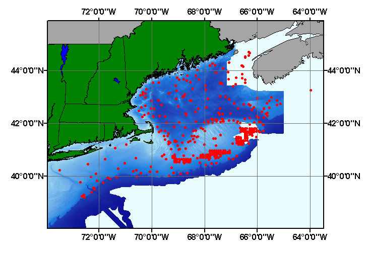
Bounding_Coordinates:
West_Bounding_Coordinate: -73.467000
East_Bounding_Coordinate: -63.967000
North_Bounding_Coordinate: 44.700000
South_Bounding_Coordinate: 39.200000
Keywords:
Theme:
Theme_Keyword_Thesaurus: USGS Metadata Identifier
Theme_Keyword: USGS:2c0f245a-dfa0-47ca-8735-81873aa817e6
Theme:
Theme_Keyword_Thesaurus: None
Theme_Keyword: U.S. Geological Survey
Theme_Keyword: USGS
Theme_Keyword: Coastal and Marine Geology Program
Theme_Keyword: Woods Hole Science Center
Theme_Keyword: WHSC
Theme_Keyword: National Geophysical Data Center
Theme_Keyword: NGDC
Theme_Keyword: Bureau of Commercial Fisheries
Theme_Keyword: Deck 41
Theme_Keyword: sediment
Theme_Keyword: texture
Theme_Keyword: gravel
Theme_Keyword: sand
Theme_Keyword: silt
Theme_Keyword: clay
Theme_Keyword: CMGP
Theme_Keyword: sediment classification
Theme_Keyword: gravel
Theme_Keyword: sand
Theme_Keyword: silt
Theme_Keyword: clay
Theme_Keyword: Open-File Report 03-001
Theme_Keyword: ALBATROSS-IV cruises
Theme_Keyword: ALBATROSS IV cruise 65-2
Theme_Keyword: ALBATROSS IV cruise 65-13
Theme_Keyword: ALBATROSS IV cruise 65-14.
Theme_Keyword: surficial classification
Theme_Keyword: GIS
Theme_Keyword: Geographic Information System
Theme_Keyword: point shapefile
Theme_Keyword: points
Theme:
Theme_Keyword_Thesaurus: ISO 19115 Topic Category
Theme_Keyword: oceans
Theme_Keyword: location
Theme_Keyword: geoscientificInformation
Theme:
Theme_Keyword_Thesaurus: USGS Thesaurus
Theme_Keyword: grain-size analysis
Theme_Keyword: navigational data
Theme_Keyword: geospatial datasets
Theme_Keyword: sea-floor characteristics
Theme_Keyword: marine geology
Place:
Place_Keyword_Thesaurus: None
Place_Keyword: Gulf of Maine
Place_Keyword: Georges Bank
Place_Keyword: outer continental shelf
Place_Keyword: U.S. northeast
Place_Keyword: U.S. East Coast
Place_Keyword: Atlantic Ocean
Access_Constraints: None
Use_Constraints:
Public domain data from the U.S. Government are freely redistributable with proper metadata and source attribution. Please recognize the U.S. Geological Survey (USGS) as the source of this information.
Point_of_Contact:
Contact_Information:
Contact_Person_Primary:
Contact_Person: Lawrence J. Poppe
Contact_Organization: U.S. Geological Survey
Contact_Position: Geologist
Contact_Address:
Address_Type: mailing and physical address
Address: 384 Woods Hole Road
City: Woods Hole
State_or_Province: MA
Postal_Code: 02543-1598
Country: USA
Contact_Voice_Telephone: (508) 548-8700 x2314
Contact_Facsimile_Telephone: (508) 457-2310
Contact_Electronic_Mail_Address: [email protected]
Browse_Graphic:
Browse_Graphic_File_Name:
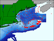
Browse_Graphic_File_Description:
Thumbnail image showing extent and distribution of data layer coverage.
Browse_Graphic_File_Type: GIF
Browse_Graphic:
Browse_Graphic_File_Name:
Browse_Graphic_File_Description:
Image map showing extent and distribution of data layer coverage.
Browse_Graphic_File_Type: GIF
Data_Set_Credit:
National Geophysical Data Center (NGDC) for supplying the original unpublished data sheets; Larry Poppe for creating the shapefile.
Native_Data_Set_Environment:
Microsoft Windows XP Version 5.1 (Build 2600) Service Pack 2; ESRI ArcCatalog 9.2.2.1350
Cross_Reference:
Citation_Information:
Originator: R.L. Wigley
Publication_Date: Unpublished Material
Title: Raw Data Sheets
Edition: 1.0
Publication_Information:
Publication_Place: Woods Hole, MA
Publisher: Bureau of Commercial Fisheries
Other_Citation_Details:
Data collected during 1965 aboard the ALBATROSS IV during cruises 65-2, 65-13, and 65-14