Citation:
Citation_Information:
Originator: David C. Twichell
Originator: VeeAnn A. Cross
Publication_Date: 2003
Title:
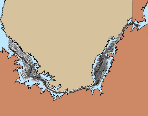
2 meter unenhanced GeoTIFF Sidescan-Sonar Mosaic East of Virgin Basin - Lake Mead, Nevada (TEMPICE_UNGEOG.TIF , geographic)
Edition: 1.0
Geospatial_Data_Presentation_Form: remote-sensing image
Series_Information:
Series_Name: Open-File Report
Issue_Identification: 03-320
Publication_Information:
Publication_Place: Woods Hole Coastal and Marine Science Center, Woods Hole, MA
Publisher: U.S. Geological Survey, Coastal and Marine Geology Program
Online_Linkage: https://doi.org/10.3133/ofr03320
Online_Linkage:
Online_Linkage:
Online_Linkage:
Larger_Work_Citation:
Citation_Information:
Originator: David C. Twichell
Originator: VeeAnn A. Cross
Originator: Stephen D. Belew
Publication_Date: 2003
Title:
Mapping the floor of Lake Mead (Nevada and Arizona): Preliminary discussion and GIS data release
Edition: 1.0
Series_Information:
Series_Name: Open-File Report
Issue_Identification: 03-320
Publication_Information:
Publication_Place: Reston, VA
Publisher: U.S. Geological Survey
Online_Linkage: https://doi.org/10.3133/ofr03320
Online_Linkage: https://pubs.usgs.gov/of/2003/of03-320/
Description:
Abstract:
Lake Mead is a large interstate reservoir located in the Mojave Desert of southeastern Nevada and northwestern Arizona. It was impounded in 1935 by the construction of Hoover Dam and is one of a series of multi-purpose reservoirs on the Colorado River. The lake extends 183 km from the mouth of the Grand Canyon to Black Canyon, the site of Hoover Dam, and provides water for residential, commercial, industrial, recreational, and other non-agricultural users in communities across the southwestern United States. Extensive research has been conducted on Lake Mead, but a majority of the studies have involved determining levels of anthropogenic contaminants such as synthetic organic compounds, heavy metals and dissolved ions, furans/dioxins, and nutrient loading in lake water, sediment, and biota (Preissler, et al., 1998; Bevans et al, 1996; Bevans et al., 1998; Covay and Leiker, 1998; LaBounty and Horn, 1997; Paulson, 1981). By contrast, little work has focused on the sediments in the lake and the processes of deposition (Gould, 1951). To address these questions, sidescan-sonar imagery and high-resolution seismic-reflection profiles were collected throughout Lake Mead by the USGS in cooperation with researchers from University of Nevada Las Vegas (UNLV). These data allow a detailed mapping of the surficial geology and the distribution and thickness of sediment that has accumulated in the lake since the completion of Hoover Dam. Results indicate that the accumulation of post-impoundment sediment is primarily restricted to former river and stream beds that are now submerged below the lake while the margins of the lake appear to be devoid of post-impoundment sediment. The sediment cover along the original Colorado River bed is continuous and is typically greater than 10 m thick through much of its length. Sediment thickness in some areas exceeds 35 m while the smaller tributary valleys typically are filled with less than 4 m of sediment. Away from the river beds that are now covered with post-impoundment sediment, pre-impoundment alluvial deposits and rock outcrops are still exposed on the lake floor.
Purpose:
This sidescan-sonar imagery is used to map the morphology of the lake floor and determine the extent of sediment distribution on the lake floor.
Time_Period_of_Content:
Time_Period_Information:
Range_of_Dates/Times:
Beginning_Date: 20010401
Ending_Date: 20010426
Currentness_Reference: ground condition
Status:
Progress: Complete
Maintenance_and_Update_Frequency: None planned
Spatial_Domain:
Bounding_Coordinates:
West_Bounding_Coordinate: -114.368921
East_Bounding_Coordinate: -114.022360
North_Bounding_Coordinate: 36.206732
South_Bounding_Coordinate: 36.000692
Keywords:
Theme:
Theme_Keyword_Thesaurus: USGS Metadata Identifier
Theme_Keyword: USGS:9d9a5f69-c5f4-4b90-a3a4-b09cc093b1d8
Theme:
Theme_Keyword_Thesaurus: None
Theme_Keyword: CMGP
Theme_Keyword: Coastal and Marine Geology Program
Theme_Keyword: images
Theme_Keyword: mosaic
Theme_Keyword: OFR03-320
Theme_Keyword: Open-File Report
Theme_Keyword: reservoir
Theme_Keyword: sidescan
Theme_Keyword: sidescan sonar
Theme_Keyword: GeoTIFF
Theme_Keyword: U.S. Geological Survey
Theme_Keyword: USGS
Theme_Keyword: Woods Hole Science Center
Theme_Keyword: WHSC
Theme:
Theme_Keyword_Thesaurus: ISO 19115 Topic Category
Theme_Keyword: inlandWaters
Theme_Keyword: imageryBaseMapsEarthCover
Theme_Keyword: geoscientificInformation
Theme:
Theme_Keyword_Thesaurus: USGS Thesaurus
Theme_Keyword: lakebed acoustic reflectivity
Theme_Keyword: image mosaics
Theme_Keyword: sidescan sonar
Theme_Keyword: geophysics
Theme_Keyword: geospatial datasets
Place:
Place_Keyword_Thesaurus: None
Place_Keyword: Arizona
Place_Keyword: Colorado River
Place_Keyword: Iceberg Canyon
Place_Keyword: Lake Mead
Place_Keyword: Las Vegas
Place_Keyword: Mojave Desert
Place_Keyword: Nevada
Place_Keyword: Overton Arm
Place_Keyword: United States
Place_Keyword: Virgin Basin
Place_Keyword: North America
Access_Constraints: NONE
Use_Constraints:
The U.S. Geological Survey must be referenced as the originator of the dataset in any future products or research derived from these data.
Public domain data from the U.S. government is freely redistributable with proper metadata and source attribution.
Point_of_Contact:
Contact_Information:
Contact_Person_Primary:
Contact_Person: David C. Twichell
Contact_Organization: U.S. Geological Survey
Contact_Position: Oceanographer
Contact_Address:
Address_Type: mailing and physical address
Address: 384 Woods Hole Rd.
City: Woods Hole
State_or_Province: MA
Postal_Code: 02543-1598
Contact_Voice_Telephone: (508) 548-8700 x2266
Contact_Facsimile_Telephone: (508) 457-2310
Contact_Electronic_Mail_Address: [email protected]
Browse_Graphic:
Browse_Graphic_File_Name:
Browse_Graphic_File_Description:
Browse image showing overview of East Virgin Basin sidescan-sonar mosaic.
Browse_Graphic_File_Type: JPEG
Native_Data_Set_Environment:
Microsoft Windows XP Version 5.1 (Build 2600) Service Pack 2; ESRI ArcCatalog 9.2.2.1350
Cross_Reference:
Citation_Information:
Originator: H.E. Bevans
Originator: S.L. Goodbred
Originator: J.F. Miesner
Originator: S.A. Watkins
Originator: T.S. Gross
Originator: N.D. Denslow
Originator: T. Choeb
Publication_Date: 1996
Title:
Synthetic organic compounds and carp endrocrinology and histology, Las Vegas Wash and Las Vegas and Callville bays of Lake Mead Nevada
Series_Information:
Series_Name: Water-Resources Investigations
Issue_Identification: 96-4266
Publication_Information:
Publication_Place: Reston, VA
Publisher: U.S. Geological Survey
Cross_Reference:
Citation_Information:
Originator: H.E. Bevans
Originator: M.S. Lico
Originator: S.J. Lawrence
Publication_Date: 1998
Title:
Water quality in the Las Vegas Valley area and the Carson and Truckee River basins, Nevada and California, 1992-1996
Series_Information:
Series_Name: Circular
Issue_Identification: 1170
Publication_Information:
Publication_Place: Reston, VA
Publisher: U.S. Geological Survey
Cross_Reference:
Citation_Information:
Originator: K.J. Couvay
Originator: T.J. Leiker
Publication_Date: 1998
Title:
Synthetic organic compounds in water and bottom sediment from streams, detention basins, and sewage-treatment plant outfalls in Las Vegas Valley, Nevada, 1997
Series_Information:
Series_Name: Open-File Report
Issue_Identification: 98-633
Publication_Information:
Publication_Place: Reston, VA
Publisher: U.S. Geological Survey
Cross_Reference:
Citation_Information:
Originator: H.R. Gould
Publication_Date: 1951
Title: Some quantitative aspects of Lake Mead turbidity currents
Series_Information:
Series_Name: SEPM Special Publication
Issue_Identification: No. 2
Publication_Information:
Publication_Place: Tulsa, OK
Publisher: Society of Economic Paleontologists and Mineralogists
Cross_Reference:
Citation_Information:
Originator: J.F. LaBounty
Originator: M.J. Horn
Publication_Date: 1997
Title:
The influence of drainage from the Las Vegas Valley on the limnology of Boulder Basin, Lake Mead, Arizona-Nevada
Series_Information:
Series_Name: Journal of Lake and Reservoir Management
Issue_Identification: v. 13
Cross_Reference:
Citation_Information:
Originator: L.J. Paulson
Publication_Date: 1981
Title:
Nutrient management with hydroelectric dams on the Colorado River
Series_Information:
Series_Name: Technical Report
Issue_Identification: #8
Publication_Information:
Publication_Place:
Department of Biological Sciences, University of Nevada, Las Vegas, Nevada
Publisher: Lake Mead Limnological Research Center
Cross_Reference:
Citation_Information:
Originator: A.M. Preissler
Originator: G.A. Roach
Originator: K.A. Thomas
Originator: J.W. Wilson
Publication_Date: 1998
Title: Water resources data, Nevada, water year 1998
Series_Information:
Series_Name: Water Resources Data Nevada
Issue_Identification: NV-98-1
Publication_Information:
Publication_Place: Reston, VA
Publisher: U.S. Geological Survey