Citation:
Citation_Information:
Originator: Lawrence J. Poppe
Publication_Date: 2004
Title:
Surficial sediment distribution interpretation of the sidescan sonar mosaic of National Oceanic and Atmospheric Administration (NOAA) survey H11043 off Branford, Connecticut
Edition: 1.0
Geospatial_Data_Presentation_Form: vector digital data
Series_Information:
Series_Name: Open-File Report
Issue_Identification: 2004-1003
Publication_Information:
Publication_Place: Woods Hole Coastal and Marine Science Center, Woods Hole, MA
Publisher: U.S. Geological Survey, Coastal and Marine Geology Program
Online_Linkage: https://doi.org/10.3133/ofr20041003
Online_Linkage:
Online_Linkage: http://pubs.usgs.gov/of/2004/1003/htmldocs/data_catalog.htm
Larger_Work_Citation:
Citation_Information:
Originator: L.J. Poppe
Originator: V.F. Paskevich
Originator: M.S. Moser
Originator: M.L. DiGiacomo-Cohen
Originator: E.B. Christman
Publication_Date: 2004
Title:
Sidescan Sonar Imagery and Surficial Geologic Interpretation of the Sea Floor off Branford, Connecticut
Edition: 1.0
Series_Information:
Series_Name: Open-File Report
Issue_Identification: 2004-1003
Publication_Information:
Publication_Place: Reston, VA
Publisher: U.S. Geological Survey
Other_Citation_Details: 1 CD-ROM
Online_Linkage: http://pubs.usgs.gov/of/2004/1003/
Description:
Abstract:
The U.S. Geological Survey, in cooperation with the National Oceanic and Atmospheric Administration and the Connecticut Department of Environmental Protection, has produced detailed geologic maps of the sea floor in Long Island Sound, a major East Coast estuary surrounded by the most densely populated region of the United States. These studies have built upon cooperative research with the State of Connecticut that was initiated in 1982. The current phase of this research program is directed toward studies of sea-floor sediment distribution, processes that control sediment distribution, nearshore environmental concerns, and the relation of benthic community structures to the sea-floor geology.
Anthropogenic wastes, toxic chemicals, and changes in land-use patterns resulting from residential, commercial, and recreational development have stressed the environment of the Sound, causing degradation and potential loss of benthic habitats (Koppelman and others, 1976; Long Island Sound Study, 1994). Detailed maps of the sea floor are needed to help evaluate the extent of adverse impacts and to help manage resources wisely in the future. Therefore, in a continuing effort to better understand Long Island Sound, we have constructed and interpreted sidescan sonar mosaics (complete-coverage acoustic images of the sea floor) within specific areas of special interest (Poppe and Polloni, 1998; fig. 1). The mosaic presented herein covers a 41.1 km square area of the sea floor in north-central Long Island Sound off Branford, Connecticut.
The mosaics and their interpretations serve many purposes, including: (1) defining the geological variability of the sea floor, which is one of the primary controls of benthic habitat diversity; (2) improving our understanding of the processes that control the distribution and transport of bottom sediments and the distribution of benthic habitats and associated infaunal community structures; and (3) providing a detailed framework for future research, monitoring, and management activities. The sidescan sonar mosaics also serve as base maps for subsequent sedimentological, geochemical, and biological observations, because precise information on environmental setting is important for selection of sampling sites and for accurate interpretation of point measurements.
Purpose:
To release the interpretation of the surficial sediment distribution of the sidescan sonar data acquired by National Oceanic and Atmospheric Administration (NOAA) survey H11043. This GIS data layer is a component of the Branford Survey, Long Island Sound GIS.
Time_Period_of_Content:
Time_Period_Information:
Single_Date/Time:
Calendar_Date: 2004
Currentness_Reference: publication date
Status:
Progress: Complete
Maintenance_and_Update_Frequency: None planned
Spatial_Domain:
Bounding_Coordinates:
West_Bounding_Coordinate: -72.869918
East_Bounding_Coordinate: -72.776520
North_Bounding_Coordinate: 41.236011
South_Bounding_Coordinate: 41.151390
Keywords:
Theme:
Theme_Keyword_Thesaurus: USGS Metadata Identifier
Theme_Keyword: USGS:2deab2ef-d302-44b8-a826-3b4e35af5421
Theme:
Theme_Keyword_Thesaurus: None
Theme_Keyword: U.S. Geological Survey
Theme_Keyword: USGS
Theme_Keyword: Coastal and Marine Geology Program
Theme_Keyword: CMGP
Theme_Keyword: National Oceanic and Atmospheric Administration
Theme_Keyword: NOAA
Theme_Keyword: Woods Hole Science Center
Theme_Keyword: WHSC
Theme_Keyword: Connecticut Department of Environmental Protection
Theme_Keyword: CT-DEP
Theme_Keyword: NOAA Ship RUDE
Theme_Keyword: sediment
Theme_Keyword: texture
Theme_Keyword: gravel
Theme_Keyword: gravelly sediment
Theme_Keyword: sand
Theme_Keyword: silty sand
Theme_Keyword: sand silt clay
Theme_Keyword: clayey silt
Theme_Keyword: sedimentary interpretation
Theme_Keyword: polygon shapefile
Theme_Keyword: Geographic Information System
Theme:
Theme_Keyword_Thesaurus: ISO 19115 Topic Category
Theme_Keyword: oceans
Theme_Keyword: geoscientificInformation
Theme:
Theme_Keyword_Thesaurus: USGS Thesaurus
Theme_Keyword: scientific interpretation
Theme_Keyword: sea-floor characteristics
Theme_Keyword: marine geology
Theme_Keyword: geospatial datasets
Place:
Place_Keyword_Thesaurus: None
Place_Keyword: Long Island Sound
Place_Keyword: Branford
Place_Keyword: Townshend Ledge
Place_Keyword: Branford Reef
Place_Keyword: Connecticut
Place_Keyword: east coast
Place_Keyword: northeast
Place_Keyword: US Atlantic East Coast
Place_Keyword: U.S. East Coast
Place_Keyword: Atlantic Margin
Place_Keyword: United States
Place_Keyword: Atlantic Ocean
Place_Keyword: North America
Access_Constraints: None
Use_Constraints:
Public domain data are freely redistributable with proper metadata and source attribution. Please recognize the U.S. Geological Survey (USGS) as the originator of this dataset.
Point_of_Contact:
Contact_Information:
Contact_Organization_Primary:
Contact_Organization: U.S. Geological Survey
Contact_Person: Lawrence J. Poppe
Contact_Position: Geologist
Contact_Address:
Address_Type: mailing and physical address
Address: 384 Woods Hole Road
City: Woods Hole
State_or_Province: MA
Postal_Code: 02543
Country: USA
Contact_Voice_Telephone: (508) 548-8700
Contact_Facsimile_Telephone: (508) 457-2310
Contact_Electronic_Mail_Address: lpoppe@usgs.gov
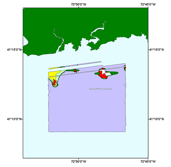
Browse_Graphic:
Browse_Graphic_File_Name:
Browse_Graphic_File_Description:
Overview showing the coverage and extent of the sediment texture interpretation data layer for the H11043 NOAA sidescan sonar mosaic.
Browse_Graphic_File_Type: GIF
Data_Set_Credit:
Lawrence J. Poppe, U.S. Geological Survey, must be referenced as the originator of the dataset in any future products or research derived from these data.
Native_Data_Set_Environment:
Microsoft Windows XP Version 5.1 (Build 2600) Service Pack 2; ESRI ArcCatalog 9.2.2.1350