Citation:
Citation_Information:
Originator: U.S. Geological Survey
Originator: National Oceanic and Atmospheric Administration
Publication_Date: 2003
Title:
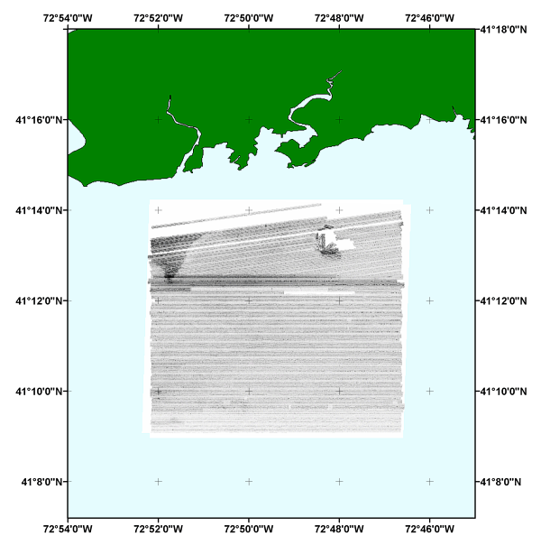
Composite sidescan sonar mosaic in UTM zone 18 projection of NOAA survey H11043 off Branford, Connecticut (H11043_UTM18_WGS84.TIF)
Edition: 1.0
Geospatial_Data_Presentation_Form: remote-sensing image
Publication_Information:
Publication_Place: Woods Hole Coastal and Marine Science Center, Woods Hole, MA
Publisher: U.S. Geological Survey, Coastal and Marine Geology Program
Other_Citation_Details: Data are released via CD-ROM media.
Online_Linkage: https://doi.org/10.3133/ofr20041003
Online_Linkage:
Larger_Work_Citation:
Citation_Information:
Originator: L.J. Poppe
Originator: V.F. Paskevich
Originator: M.S. Moser
Originator: M.L. DiGiacomo-Cohen
Originator: E.B. Christman
Publication_Date: 2004
Title:
Sidescan Sonar Imagery and Surficial Geologic Interpretation of the Sea Floor off Branford, Connecticut
Edition: 1.0
Series_Information:
Series_Name: Open-File Report
Issue_Identification: 2004-1003
Publication_Information:
Publication_Place: Reston, VA
Publisher: U.S. Geological Survey
Other_Citation_Details:
This digital publication may also be available via the web at pubs.usgs.gov
Online_Linkage: https://pubs.usgs.gov/of/2004/1003/
Description:
Abstract:
The U.S. Geological Survey, in cooperation with the National Oceanic and Atmospheric Administration and the Connecticut Department of Environmental Protection, has produced detailed geologic maps of the sea floor in Long Island Sound, a major East Coast estuary surrounded by the most densely populated region of the United States. These studies have built upon cooperative research with the State of Connecticut that was initiated in 1982. The current phase of this research program is directed toward studies of sea-floor sediment distribution, processes that control sediment distribution, nearshore environmental concerns, and the relation of benthic community structures to the sea-floor geology.
Anthropogenic wastes, toxic chemicals, and changes in land-use patterns resulting from residential, commercial, and recreational development have stressed the environment of the Sound, causing degradation and potential loss of benthic habitats (Koppelman and others, 1976; Long Island Sound Study, 1994). Detailed maps of the sea floor are needed to help evaluate the extent of adverse impacts and to help manage resources wisely in the future. Therefore, in a continuing effort to better understand Long Island Sound, we have constructed and interpreted sidescan sonar mosaics (complete-coverage acoustic images of the sea floor) within specific areas of special interest. The mosaic presented herein covers a 41.1 km square area of the sea floor in north-central Long Island Sound off Branford, Connecticut.
The mosaics and their interpretations serve many purposes, including: (1) defining the geological variability of the sea floor, which is one of the primary controls of benthic habitat diversity; (2) improving our understanding of the processes that control the distribution and transport of bottom sediments and the distribution of benthic habitats and associated infaunal community structures; and (3) providing a detailed framework for future research, monitoring, and management activities. The sidescan sonar mosaics also serve as base maps for subsequent sedimentological, geochemical, and biological observations, because precise information on environmental setting is important for selection of sampling sites and for accurate interpretation of point measurements.
Purpose:
This GIS overlay is a component of the Branford Survey, Long Island Sound, ArcView GIS database and contains the completed sidescan sonar mosaic for the study area. The image is projected in UTM and has not been enhanced. Light tones represent relatively harder returns, higher backscatter, and generally coarser sediments. Dark tones represent relatively softer returns, lower backscatter, and generally finer grained sediments.
Supplemental_Information:
The image includes a white background (no data) surrounding the sidescan sonar image. High dn values represent low backscatter and low dn values represent high backscatter.
Time_Period_of_Content:
Time_Period_Information:
Single_Date/Time:
Calendar_Date: 2001
Currentness_Reference: ground condition
Status:
Progress: Complete
Maintenance_and_Update_Frequency: None planned
Spatial_Domain:
Bounding_Coordinates:
West_Bounding_Coordinate: -72.869907
East_Bounding_Coordinate: -72.775833
North_Bounding_Coordinate: 41.237200
South_Bounding_Coordinate: 41.151200
Keywords:
Theme:
Theme_Keyword_Thesaurus: USGS Metadata Identifier
Theme_Keyword: USGS:fe77c96e-805c-4bb0-89c2-6fa89dd9c988
Theme:
Theme_Keyword_Thesaurus: None
Theme_Keyword: U.S. Geological Survey
Theme_Keyword: USGS
Theme_Keyword: National Oceanic and Atmospheric Administration
Theme_Keyword: NOAA
Theme_Keyword: Woods Hole Science Center
Theme_Keyword: NOAA Ship RUDE
Theme_Keyword: geotiff
Theme_Keyword: ArcView
Theme_Keyword: sidescan sonar mosaic
Theme_Keyword: image
Theme:
Theme_Keyword_Thesaurus: ISO 19115 Topic Category
Theme_Keyword: oceans
Theme_Keyword: geoscientificInformation
Theme_Keyword: imageryBaseMapsEarthCover
Theme:
Theme_Keyword_Thesaurus: USGS Thesaurus
Theme_Keyword: bathymetry
Theme_Keyword: sea-floor characteristics
Theme_Keyword: interferometric sonar
Theme_Keyword: image mosaics
Theme_Keyword: marine geophysics
Theme_Keyword: geospatial datasets
Place:
Place_Keyword_Thesaurus: None
Place_Keyword: North America
Place_Keyword: United States
Place_Keyword: Atlantic Ocean
Place_Keyword: North Atlantic Ocean
Place_Keyword: northeast United States
Place_Keyword: Long Island Sound
Place_Keyword: Connecticut
Place_Keyword: U.S. East Coast
Place_Keyword: Townshend Ledge
Place_Keyword: Branford Reef
Access_Constraints: None
Use_Constraints:
Public domain data are freely redistributable with proper metadata and source attribution. Please recognize the National Oceanic and Atmospheric Administration as the originator of this dataset.
Point_of_Contact:
Contact_Information:
Contact_Person_Primary:
Contact_Person: Lawrence J. Poppe
Contact_Organization: U.S. Geological Survey
Contact_Position: Geologist
Contact_Address:
Address_Type: mailing and physical address
Address: 384 Woods Hole Road
City: Woods Hole
State_or_Province: MA
Postal_Code: 02543-1598
Country: USA
Contact_Voice_Telephone: (508) 548-8700 x2314
Contact_Facsimile_Telephone: (508) 457-2310
Contact_Electronic_Mail_Address: [email protected]
Browse_Graphic:
Browse_Graphic_File_Name:
Browse_Graphic_File_Description:
Overview of the digital sidescan sonar mosaic for NOAA survey H11043 in UTM projection.
Browse_Graphic_File_Type: GIF
Data_Set_Credit:
The National Oceanic and Atmospheric Administration (NOAA) must be acknowledged as the originator of this data set.
Native_Data_Set_Environment:
Microsoft Windows 2000 Version 5.1 (Build 2600) Service Pack 1; ESRI ArcCatalog 8.3.0.800