Citation:
Citation_Information:
Originator: U.S. Geological Survey
Publication_Date: 2007
Title:
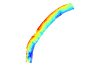
Elevation of the regional transgressive unconformity underlying the inner shelf of Long Bay (Grid; transgr_grd)
Edition: 1.0
Geospatial_Data_Presentation_Form: raster digital data
Series_Information:
Series_Name: Open-File Report
Issue_Identification: 2005-1346
Publication_Information:
Publication_Place: Woods Hole Coastal and Marine Science Center, Woods Hole, MA
Publisher: U.S. Geological Survey, Coastal and Marine Geology Program
Online_Linkage: https://doi.org/10.3133/ofr20051346
Online_Linkage:
Online_Linkage: http://pubs.usgs.gov/of/2005/1346/html/gis.html#seismic_srf
Larger_Work_Citation:
Citation_Information:
Originator: Baldwin, W.E.
Originator: Denny, J.F.
Originator: Schwab, W.C.
Originator: Gayes, P.T.
Originator: Morton, R.A.
Originator: Driscoll, N.W.
Publication_Date: 2007
Title:
Geologic Framework Studies of South Carolina's Long Bay from Little River Inlet to Winyah Bay, 1999-2003; geospatial data release
Edition: 1.0
Series_Information:
Series_Name: Open-File Report
Issue_Identification: 2005-1346
Publication_Information:
Publication_Place: Reston, VA
Publisher: U.S. Geological Survey
Other_Citation_Details: 1 DVD-ROM
Online_Linkage: http://pubs.usgs.gov/of/2005/1346/
Description:
Abstract:
In 1999, the U.S. Geological Survey (USGS), in partnership with the South Carolina Sea Grant Consortium, began a study to investigate processes affecting shoreline change along the northern coast of South Carolina, focusing on the Grand Strand region. Previous work along the U.S. Atlantic coast shows that the structure and composition of older geologic strata located seaward of the coast heavily influences the coastal behavior of areas with limited sediment supply, such as the Grand Strand. By defining this geologic framework and identifying the transport pathways and sinks of sediment, geoscientists are developing conceptual models of the present-day physical processes shaping the South Carolina coast. The primary objectives of this research effort are: 1) to provide a regional synthesis of the shallow geologic framework underlying the coastal upland, shoreface and inner continental shelf, and define its role in coastal evolution and modern beach behavior; 2) to identify and model the physical processes affecting coastal ocean circulation and sediment transport, and to define their role in shaping the modern shoreline; and 3) to identify sediment sources and transport pathways; leading to construction of a regional sediment budget.
This data set contains a surface depicting the elevation of the regional transgressive unconformity underlying the inner shelf of Long Bay, offshore of the South Carolina Grand Strand. Chirp seismic data collected with Benthos SIS-1000 and Edgetech SB-512 acquisition systems were processed using SIOSEIS (Scripps Institute of Oceanography) and Seismic Unix (Colorado School of Mines) to produce segy files and jpg images of the profiles. Data were then imported into Landmark SeisWorks, a digital seismic interpretation package, where the sea floor and underlying transgressive surface were interpreted and digitized. The isopach between these horizons was exported at every 50th shot as xyz points, and imported to ArcGIS for interpolation into a 10-m raster grid. The isopach grid was then subtracted from a seafloor bathymetry grid (bathy_grd) to approximate the proper elevation of the transgressive unconformity beneath the sea floor.
Purpose:
In 1999, the USGS, in partnership with the South Carolina Sea Grant Consortium, began a study to investigate processes affecting shoreline change along the northern coast of South Carolina, focusing on the Grand Strand region. Previous work along the U.S. Atlantic coast shows that the structure and composition of older geologic strata located seaward of the coast heavily influences the coastal behavior of areas with limited sediment supply, such as the Grand Strand. By defining this geologic framework and identifying the transport pathways and sinks of sediment, geoscientists are developing conceptual models of the present-day physical processes shaping the South Carolina coast. The primary objectives of this research effort are: 1) to provide a regional synthesis of the shallow geologic framework underlying the coastal upland, shoreface and inner continental shelf, and define its role in coastal evolution and modern beach behavior; 2) to identify and model the physical processes affecting coastal ocean circulation and sediment transport, and to define their role in shaping the modern shoreline; and 3) to identify sediment sources and transport pathways; leading to construction of a regional sediment budget.
Time_Period_of_Content:
Time_Period_Information:
Range_of_Dates/Times:
Beginning_Date: 1999
Ending_Date: 2003
Currentness_Reference: ground condition
Status:
Progress: Complete
Maintenance_and_Update_Frequency: None planned
Spatial_Domain:
Bounding_Coordinates:
West_Bounding_Coordinate: -79.158619
East_Bounding_Coordinate: -78.514899
North_Bounding_Coordinate: 33.855993
South_Bounding_Coordinate: 33.188888
Keywords:
Theme:
Theme_Keyword_Thesaurus: USGS Metadata Identifier
Theme_Keyword: USGS:113c295f-41d3-45a0-957b-2cb1fe04c939
Theme:
Theme_Keyword_Thesaurus: None
Theme_Keyword: U.S. Geological Survey
Theme_Keyword: USGS
Theme_Keyword: Coastal and Marine Geology Program
Theme_Keyword: CMGP
Theme_Keyword: Woods Hole Science Center
Theme_Keyword: WHSC
Theme_Keyword: Seafloor
Theme_Keyword: Marine Geology
Theme_Keyword: Seismic Reflection Profile
Theme_Keyword: Benthos SIS-1000
Theme_Keyword: Edgetech SB-512
Theme_Keyword: Chirp
Theme_Keyword: ArcGIS Raster
Theme_Keyword: transgressive unconformity
Theme_Keyword: elevation
Theme_Keyword: interpretation
Theme:
Theme_Keyword_Thesaurus: ISO 19115 Topic Category
Theme_Keyword: oceans
Theme_Keyword: geoscientificInformation
Theme:
Theme_Keyword_Thesaurus: USGS Thesaurus
Theme_Keyword: scientific interpretation
Theme_Keyword: geologic structure
Theme_Keyword: geospatial datasets
Theme_Keyword: marine geology
Theme_Keyword: marine geophysics
Theme_Keyword: unconformities
Place:
Place_Keyword_Thesaurus: None
Place_Keyword: South Carolina
Place_Keyword: Grand Strand
Place_Keyword: Long Bay
Place_Keyword: North Myrtle Beach
Place_Keyword: Myrtle Beach
Place_Keyword: Surfside
Place_Keyword: Garden City
Place_Keyword: Pawleys Island
Place_Keyword: Waites Island
Place_Keyword: Southeast United States
Place_Keyword: United States
Place_Keyword: Atlantic Ocean
Access_Constraints: None
Use_Constraints:
These data are NOT to be used for navigation purposes. Mariners should refer to the appropriate nautical chart.
Public domain data from the U.S. Government are freely redistributable with proper metadata and source attribution. Please recognize the U.S. Geological Survey (USGS) as the source of this information.
Point_of_Contact:
Contact_Information:
Contact_Person_Primary:
Contact_Person: Wayne Baldwin
Contact_Organization: U.S. Geological Survey
Contact_Position: Geologist
Contact_Address:
Address_Type: mailing and physical address
Address: 384 Woods Hole Rd.
City: Woods Hole
State_or_Province: MA
Postal_Code: 02543-1598
Country: USA
Contact_Voice_Telephone: 508-548-8700 x2226
Contact_Facsimile_Telephone: 508-457-2310
Contact_Electronic_Mail_Address: [email protected]
Browse_Graphic:
Native_Data_Set_Environment:
Microsoft Windows XP Version 5.1 (Build 2600) Service Pack 2; ESRI ArcCatalog 9.2.2.1350