Interpretation of the Sedimentary Environments of National Oceanic and Atmospheric Administration (NOAA) Survey H11322, Western Rhode Island Sound (H11322ENVIRONS, Geographic)

Metadata also available as - [Questions & Answers] - [Parseable text] - [XML]

Metadata:

Identification_Information:
Citation:
Citation_Information:
Originator: K.Y. McMullen
Publication_Date: 2009
Title:
Interpretation of the Sedimentary Environments of National Oceanic and Atmospheric Administration (NOAA) Survey H11322, Western Rhode Island Sound (H11322ENVIRONS, Geographic)
Edition: 1.0
Geospatial_Data_Presentation_Form: vector digital data
Series_Information:
Series_Name: Open-File Report
Issue_Identification: 2008-1181
Publication_Information:
Publication_Place: Woods Hole Coastal and Marine Science Center, Woods Hole, MA
Publisher: U.S. Geological Survey, Coastal and Marine Geology Program
Online_Linkage: https://doi.org/10.3133/ofr20081181
Online_Linkage: Online_Linkage: http://pubs.usgs.gov/of/2008/1181/html/catalog.html
Larger_Work_Citation:
Citation_Information:
Originator: K.Y. McMullen
Originator: L.J. Poppe
Originator: T.A. Haupt
Originator: J.M. Crocker
Publication_Date: 2009
Title:
Sidescan-Sonar Imagery and Surficial Geologic Interpretations of the Sea Floor in Western Rhode Island Sound
Edition: 1.0
Series_Information:
Series_Name: Open-File Report
Issue_Identification: 2008-1181
Publication_Information:
Publication_Place: Reston, VA
Publisher: U.S. Geological Survey
Other_Citation_Details: 1 DVD-ROM
Online_Linkage: http://pubs.usgs.gov/of/2008/1181/
Description:
Abstract:
The U.S. Geological Survey (USGS) is working cooperatively with the National Oceanic and Atmospheric Administration (NOAA) to interpret the surficial geology in estuaries along the coast of the northeastern United States. The purpose of our present study is to define the sea floor morphology and sedimentary environments in an area of Rhode Island Sound using sidescan-sonar and bathymetric data collected onboard the NOAA Ship RUDE, as well as historic seismic records. The mosaic, bathymetry, and their interpretations serve many purposes, including: (1) defining the geological variability of the sea floor, which is one of the primary controls of benthic habitat diversity; (2) improving our understanding of the processes that control the distribution and transport of bottom sediments and the distribution of benthic habitats and associated infaunal community structures; and (3) providing a detailed framework for future research, monitoring, and management activities. The sidescan-sonar mosaics and bathymetry images also serve as base maps for subsequent sedimentological, geochemical, and biological observations, because precise information on environmental setting is important for selection of sampling sites and for accurate interpretations of point measurements.
Purpose:
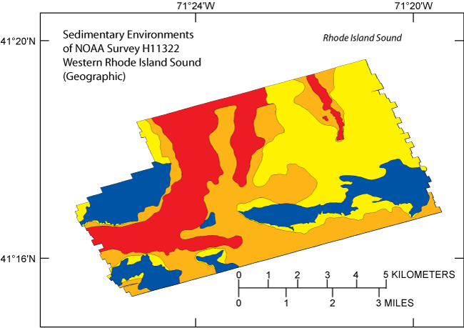
This data layer is a component of the H11322 Survey, GIS database and represents an interpretation of the sidescan-sonar mosaic for the study area. The interpretation can be used as an overlay for the mosaic image and shows the sedimentary environments of the study area such as erosion or nondeposition, sorting and reworking, deposition, and coarse-grained bedload transport.
Time_Period_of_Content:
Time_Period_Information:
Range_of_Dates/Times:
Beginning_Date: 20040706
Ending_Date: 20040716
Currentness_Reference: ground condition
Status:
Progress: Complete
Maintenance_and_Update_Frequency: None planned
Spatial_Domain:
Bounding_Coordinates:
West_Bounding_Coordinate: -71.437526
East_Bounding_Coordinate: -71.324151
North_Bounding_Coordinate: 41.328080
South_Bounding_Coordinate: 41.254770
Keywords:
Theme:
Theme_Keyword_Thesaurus: USGS Metadata Identifier
Theme_Keyword: USGS:2bab8764-a183-4dd6-8378-80ebdc92456e
Theme:
Theme_Keyword_Thesaurus: None
Theme_Keyword: U.S. Geological Survey
Theme_Keyword: USGS
Theme_Keyword: Coastal and Marine Geology Program
Theme_Keyword: CGMP
Theme_Keyword: National Oceanographic and Atmospheric Administration
Theme_Keyword: NOAA
Theme_Keyword: Woods Hole Science Center
Theme_Keyword: WHSC
Theme_Keyword: NOAA Ship RUDE
Theme_Keyword: sidescan-sonar interpretation
Theme_Keyword: sedimentary environments
Theme_Keyword: erosion
Theme_Keyword: sediment transport
Theme_Keyword: sorting and reworking
Theme_Keyword: Holocene
Theme_Keyword: Quaternary
Theme_Keyword: polygon shapefile
Theme_Keyword: Open-File Report 2008-1181
Theme_Keyword: OFR 2008-1181
Theme_Keyword: deposition
Theme_Keyword: sea floor geology
Theme_Keyword: sea floor morphology
Theme_Keyword: interpretation
Theme:
Theme_Keyword_Thesaurus: ISO 19115 Topic Category
Theme_Keyword: geoscientificInformation
Theme_Keyword: oceans
Theme:
Theme_Keyword_Thesaurus: USGS Thesaurus
Theme_Keyword: scientific interpretation
Theme_Keyword: sea-floor characteristics
Theme_Keyword: marine geology
Theme_Keyword: geospatial datasets
Place:
Place_Keyword_Thesaurus: None
Place_Keyword: Rhode Island Sound
Place_Keyword: Rhode Island
Place_Keyword: U.S. East Coast
Place_Keyword: North America
Place_Keyword: United States
Place_Keyword: Atlantic Ocean
Place_Keyword: North Atlantic Ocean
Place_Keyword: northeast United States
Place_Keyword: Point Judith
Access_Constraints: None
Use_Constraints:
Public domain data are freely redistributable with proper metadata and source attribution. Please recognize the U.S. Geological Survey as the originator of this dataset.
Point_of_Contact:
Contact_Information:
Contact_Person_Primary:
Contact_Person: Katherine McMullen
Contact_Organization: U.S. Geological Survey
Contact_Position: Sediment Lab Technician
Contact_Address:
Address_Type: mailing and physical address
Address: 384 Woods Hole Road
City: Woods Hole
State_or_Province: MA
Postal_Code: 02543
Country: USA
Contact_Voice_Telephone: (508) 548-8700 X2277
Contact_Facsimile_Telephone: (508) 457-2310
Contact_Electronic_Mail_Address: kmcmullen@usgs.gov
Browse_Graphic:
Browse_Graphic_File_Name: Browse_Graphic_File_Description:
Overview image showing the interpretation of the sedimentary environments of NOAA H11322 sidescan-sonar mosaic and bathymetry image.
Browse_Graphic_File_Type: GIF
Native_Data_Set_Environment:
Microsoft Windows XP Version 5.1 (Build 2600) Service Pack 3; ESRI ArcCatalog 9.2.6.1500
Cross_Reference:
Citation_Information:
Originator: K.Y. McMullen
Originator: L.J. Poppe
Originator: E.R. Twomey
Originator: W.W. Danforth
Originator: T.A. Haupt
Originator: J.M. Crocker
Publication_Date: 2007
Title:
Sidescan-Sonar Imagery, Multibeam Bathymetry, and Surficial Geologic Interpretations of the Sea Floor in Rhode Island Sound, off Sakonnet Point, Rhode Island
Series_Information:
Series_Name: Open-File Report
Issue_Identification: 2007-1150
Publication_Information:
Publication_Place: Reston, VA
Publisher: U.S. Geological Survey
Online_Linkage: http://pubs.usgs.gov/of/2007/1150/
Cross_Reference:
Citation_Information:
Originator: K.Y. McMullen
Originator: L.J. Poppe
Originator: J.F. Denny
Originator: T.A. Haupt
Originator: J.M. Crocker
Publication_Date: 2008
Title:
Sidescan-Sonar Imagery and Surficial Geologic Interpretations of the Sea Floor in Central Rhode Island Sound
Series_Information:
Series_Name: Open-File Report
Issue_Identification: 2007-1366
Publication_Information:
Publication_Place: Reston, VA
Publisher: U.S. Geological Survey
Online_Linkage: http://pubs.usgs.gov/of/2007/1366/
Data_Quality_Information:
Attribute_Accuracy:
Attribute_Accuracy_Report: Attributes have been visually checked by the compilers.
Logical_Consistency_Report:
Several shapefiles representing various features identified on the mosaic were combined to create this data layer. The layers were edited and processed in a consistent manner.
Completeness_Report: Layer is complete as interpreted for these features.
Positional_Accuracy:
Horizontal_Positional_Accuracy:
Horizontal_Positional_Accuracy_Report: Navigation was by differential GPS.
Lineage:
Source_Information:
Source_Citation:
Citation_Information:
Originator: U.S. Geological Survey
Originator: National Oceanographic and Atmospheric Administration
Publication_Date: 2008
Title: h11322_1m_sss_geo_str.tif
Geospatial_Data_Presentation_Form: remote-sensing image
Type_of_Source_Media: DVD-ROM
Source_Time_Period_of_Content:
Time_Period_Information:
Range_of_Dates/Times:
Beginning_Date: 20040706
Ending_Date: 20040716
Source_Currentness_Reference: ground condition
Source_Citation_Abbreviation: h11322_1m_sss_geo_str.tif
Source_Contribution:
Stretched sidescan-sonar mosaic at 1-meter resolution. The sonar image was visually interpreted to create this data layer.
Source_Information:
Source_Citation:
Citation_Information:
Originator: U.S. Geological Survey
Originator: National Oceanic and Atmospheric Administration
Publication_Date: 2008
Title: h11322_geo.tif
Source_Scale_Denominator: 45-meter resolution
Type_of_Source_Media: DVD-ROM
Source_Time_Period_of_Content:
Time_Period_Information:
Range_of_Dates/Times:
Beginning_Date: 20040706
Ending_Date: 20040716
Source_Currentness_Reference: ground condition
Source_Citation_Abbreviation: h11322_geo.tif
Source_Contribution:
Modified bathymetry image. The bathymetry image was visually interpreted to create this layer.
Process_Step:
Process_Description:
The sidescan-sonar imagery and interpolated bathymetry were interpreted to create the shapefiles representing the sedimentary environments (erosion or nondeposition, sorting and reworking, deposition, and coarse-grained bedload transport). ArcView 3.3.
Source_Used_Citation_Abbreviation: h11322_1m_sss_geo_str.tif
Source_Used_Citation_Abbreviation: h11322_geo.tif
Process_Date: 2008
Source_Produced_Citation_Abbreviation: erosion.shp
Source_Produced_Citation_Abbreviation: sortrework.shp
Source_Produced_Citation_Abbreviation: cgbt.shp
Source_Produced_Citation_Abbreviation: deposition.shp
Process_Contact:
Contact_Information:
Contact_Person_Primary:
Contact_Person: Katherine McMullen
Contact_Organization: U.S. Geological Survey
Contact_Position: Sediment Lab Technician
Contact_Address:
Address_Type: mailing and physical address
Address: 384 Woods Hole Road
City: Woods Hole
State_or_Province: MA
Postal_Code: 02543
Country: USA
Contact_Voice_Telephone: (508) 548-8700 x2277
Contact_Facsimile_Telephone: (508) 457-2310
Contact_Electronic_Mail_Address: kmcmullen@usgs.gov
Process_Step:
Process_Description:
The shapefiles were copied and pasted into one shapefile in ArcView and polygons were attributed. The general snapping environment was set and verticies were adjusted so that intersections of polygons shared verticies and line segments. ArcView 3.3.
Source_Used_Citation_Abbreviation: erosion.shp
Source_Used_Citation_Abbreviation: sortrework.shp
Source_Used_Citation_Abbreviation: cgbt.shp
Source_Used_Citation_Abbreviation: deposition.shp
Process_Date: 2008
Source_Produced_Citation_Abbreviation: h11322environs.shp
Process_Contact:
Contact_Information:
Contact_Person_Primary:
Contact_Person: Katherine McMullen
Contact_Organization: U.S. Geological Survey
Contact_Position: Sediment Lab Technician
Contact_Address:
Address_Type: mailing and physical address
Address: 384 Woods Hole Road
City: Woods Hole
State_or_Province: MA
Postal_Code: 02543
Country: USA
Contact_Voice_Telephone: (508) 548-8700 x2277
Contact_Facsimile_Telephone: (508) 457-2310
Contact_Electronic_Mail_Address: kmcmullen@usgs.gov
Process_Step:
Process_Description:
The projection was defined as geographic WGS84 in ArcGIS 9.2 using the Define Projection Tool.
Source_Used_Citation_Abbreviation: h11322environs.shp
Process_Date: 2008
Source_Produced_Citation_Abbreviation: h11322environs.prj
Process_Contact:
Contact_Information:
Contact_Person_Primary:
Contact_Person: Katherine McMullen
Contact_Organization: U.S. Geological Survey
Contact_Position: Sediment Lab Technician
Contact_Address:
Address_Type: mailing and physical address
Address: 384 Woods Hole Road
City: Woods Hole
State_or_Province: MA
Postal_Code: 02543
Country: USA
Contact_Voice_Telephone: (508) 548-8700 x2277
Contact_Facsimile_Telephone: (508) 457-2310
Contact_Electronic_Mail_Address: kmcmullen@usgs.gov
Process_Step:
Process_Description:
Edits to the metadata were made to fix any errors that MP v 2.9.32 flagged. This is necessary to enable the metadata to be successfully harvested for various data catalogs. In some cases, this meant adding text "Information unavailable" or "Information unavailable from original metadata" for those required fields that were left blank. Other minor edits were probably performed (title, publisher, publication place, etc.). The metadata date (but not the metadata creator) was edited to reflect the date of these changes. The metadata available from a harvester may supersede metadata bundled within a download file. Compare the metadata dates to determine which metadata file is most recent.
Process_Date: 20160603
Process_Contact:
Contact_Information:
Contact_Organization_Primary:
Contact_Organization: U.S. Geological Survey
Contact_Person: VeeAnn A. Cross
Contact_Position: Marine Geologist
Contact_Address:
Address_Type: mailing and physical address
Address: 384 Woods Hole Rd.
City: Woods Hole
State_or_Province: MA
Postal_Code: 02543
Contact_Voice_Telephone: 508-548-8700 x2251
Contact_Facsimile_Telephone: 508-457-2310
Contact_Electronic_Mail_Address: vatnipp@usgs.gov
Process_Step:
Process_Description: USGS Thesaurus keywords added to the keyword section.
Process_Date: 20180720
Process_Contact:
Contact_Information:
Contact_Organization_Primary:
Contact_Organization: U.S. Geological Survey
Contact_Person: VeeAnn A. Cross
Contact_Position: Marine Geologist
Contact_Address:
Address_Type: Mailing and Physical
Address: 384 Woods Hole Road
City: Woods Hole
State_or_Province: MA
Postal_Code: 02543-1598
Contact_Voice_Telephone: 508-548-8700 x2251
Contact_Facsimile_Telephone: 508-457-2310
Contact_Electronic_Mail_Address: vatnipp@usgs.gov
Process_Step:
Process_Description: Crossref DOI link was added as the first link in the metadata.
Process_Date: 20191118
Process_Contact:
Contact_Information:
Contact_Organization_Primary:
Contact_Organization: U.S. Geological Survey
Contact_Person: VeeAnn A. Cross
Contact_Position: Marine Geologist
Contact_Address:
Address_Type: Mailing and Physical
Address: 384 Woods Hole Road
City: Woods Hole
State_or_Province: MA
Postal_Code: 02543-1598
Contact_Voice_Telephone: 508-548-8700 x2251
Contact_Facsimile_Telephone: 508-457-2310
Contact_Electronic_Mail_Address: vatnipp@usgs.gov
Process_Step:
Process_Description:
Added keywords section with USGS persistent identifier as theme keyword.
Process_Date: 20200908
Process_Contact:
Contact_Information:
Contact_Organization_Primary:
Contact_Organization: U.S. Geological Survey
Contact_Person: VeeAnn A. Cross
Contact_Position: Marine Geologist
Contact_Address:
Address_Type: Mailing and Physical
Address: 384 Woods Hole Road
City: Woods Hole
State_or_Province: MA
Postal_Code: 02543-1598
Contact_Voice_Telephone: 508-548-8700 x2251
Contact_Facsimile_Telephone: 508-457-2310
Contact_Electronic_Mail_Address: vatnipp@usgs.gov
Spatial_Data_Organization_Information:
Direct_Spatial_Reference_Method: Vector
Point_and_Vector_Object_Information:
SDTS_Terms_Description:
SDTS_Point_and_Vector_Object_Type: G-polygon
Point_and_Vector_Object_Count: 21
Spatial_Reference_Information:
Horizontal_Coordinate_System_Definition:
Geographic:
Latitude_Resolution: 0.000001
Longitude_Resolution: 0.000001
Geographic_Coordinate_Units: Decimal degrees
Geodetic_Model:
Horizontal_Datum_Name: D_WGS_1984
Ellipsoid_Name: WGS_1984
Semi-major_Axis: 6378137.000000
Denominator_of_Flattening_Ratio: 298.257224
Entity_and_Attribute_Information:
Detailed_Description:
Entity_Type:
Entity_Type_Label: h11322environs
Entity_Type_Definition: Shapefile Attribute Table
Entity_Type_Definition_Source: ESRI
Attribute:
Attribute_Label: FID
Attribute_Definition: Internal feature number.
Attribute_Definition_Source: ESRI
Attribute_Domain_Values:
Unrepresentable_Domain:
Sequential unique whole numbers that are automatically generated.
Attribute:
Attribute_Label: Shape
Attribute_Definition: Feature geometry.
Attribute_Definition_Source: ESRI
Attribute_Domain_Values:
Unrepresentable_Domain: Coordinates defining the features.
Attribute:
Attribute_Label: ID
Attribute_Definition: Internal feature number.
Attribute_Definition_Source: ESRI
Attribute_Domain_Values:
Unrepresentable_Domain: Information unavailable from original metadata.
Attribute:
Attribute_Label: LABEL
Attribute_Definition:
Interpretation of sedimentary environments based on the sidescan-sonar mosaic and bathymetry
Attribute_Definition_Source: compiler
Attribute_Domain_Values:
Enumerated_Domain:
Enumerated_Domain_Value: Erosion
Enumerated_Domain_Value_Definition:
erosion or nondeposition characterized by high backscatter in the sidescan-sonar image and clusters of boulders indicating coarser grained sediment reflective of higher energy environments
Enumerated_Domain_Value_Definition_Source: USGS
Attribute_Domain_Values:
Enumerated_Domain:
Enumerated_Domain_Value: Sort_rework
Enumerated_Domain_Value_Definition:
sorting and reworking characterized by moderate backscatter in the sidescan-sonar imagery and the sea floor tends to be relatively smooth
Enumerated_Domain_Value_Definition_Source: USGS
Attribute_Domain_Values:
Enumerated_Domain:
Enumerated_Domain_Value: Cgbt
Enumerated_Domain_Value_Definition:
Coarse-grained bedload transport characterized by bathymetric highs and where there are sand waves
Enumerated_Domain_Value_Definition_Source: USGS
Attribute_Domain_Values:
Enumerated_Domain:
Enumerated_Domain_Value: Deposition
Enumerated_Domain_Value_Definition:
fine-grained deposition characterized by low backscatter in the sidescan-sonar imagery and typically occurring in part of the channel and bathymetric lows
Enumerated_Domain_Value_Definition_Source: USGS
Overview_Description:
Entity_and_Attribute_Overview:
Polygons are attributed as features based on the interpretation of the sidescan-sonar mosaic and multibeam bathymetry sedimentary environments (erosion or nondeposition, sorting and reworking, deposition, and coarse-grained bedload transport).
Entity_and_Attribute_Detail_Citation: U.S. Geological Survey
Distribution_Information:
Distributor:
Contact_Information:
Contact_Person_Primary:
Contact_Person: Lawrence Poppe
Contact_Organization: U.S. Geological Survey
Contact_Position: Geologist
Contact_Address:
Address_Type: mailing and physical address
Address: 384 Woods Hole Road
City: Woods Hole
State_or_Province: MA
Postal_Code: 02543
Country: USA
Contact_Voice_Telephone: (508) 548-8700 x2314
Contact_Facsimile_Telephone: (508) 457-2310
Contact_Electronic_Mail_Address: lpoppe@usgs.gov
Resource_Description:
Downloadable Data: Sedimentary environments of NOAA Survey H11322 in Rhode Island Sound
Distribution_Liability:
Neither the U.S. Government, the Department of the Interior, nor the USGS, nor any of their employees, contractors, or subcontractors, make any warranty, express or implied, nor assume any legal liability or responsibility for the accuracy, completeness, or usefulness of any information, apparatus, product, or process disclosed, nor represent that its use would not infringe on privately owned rights. The act of distribution shall not constitute any such warranty, and no responsibility is assumed by the USGS in the use of these data or related materials.
Standard_Order_Process:
Digital_Form:
Digital_Transfer_Information:
Format_Name: SHP
Format_Version_Number: ArcView 3.3
Format_Specification: ESRI Shapefile
Format_Information_Content:
The SHP file contains the geospatial data. The SHX file contains the index of the geospatial data. The DBF file contains the attribute data in dBase format. The PRJ file contains the coordinate system information. The SBN and SBX files contain the spatial index of the geospatial data (optional). The XML file contains the metadata describing the data set <data set name>.shp.xml. Three other forms of the metadata are also available: FGDC html, FAQ html, and ASCII text. In addtion a browse graphic showing the data layer coverage and extent is included.
File_Decompression_Technique: zip archive
Transfer_Size: 0.093
Digital_Transfer_Option:
Online_Option:
Computer_Contact_Information: Access_Instructions: Data are downloadable via the World Wide Web (WWW).
Offline_Option:
Offline_Media: DVD-ROM
Recording_Capacity:
Recording_Density: 4.75
Recording_Density_Units: Gbytes
Recording_Format: UDF
Fees: None
Technical_Prerequisites:
These data are available in Environmental Systems Research Institute (ESRI) shapefile format. The user must have ArcGIS or ArcView 3.0 or greater software to read and process the data file. In lieu of ArcView or ArcGIS, the user may utilize another GIS application package capable of importing the data. A free data viewer, ArcExplorer, capable of displaying the data is available from ESRI at www.esri.com.
Available_Time_Period:
Time_Period_Information:
Single_Date/Time:
Calendar_Date: 2009
Metadata_Reference_Information:
Metadata_Date: 20211116
Metadata_Contact:
Contact_Information:
Contact_Organization_Primary:
Contact_Organization: U.S. Geological Survey
Contact_Person: Katherine McMullen
Contact_Position: Sediment Lab Technician
Contact_Address:
Address_Type: mailing and physical address
Address: 384 Woods Hole Road
City: Woods Hole
State_or_Province: MA
Postal_Code: 02543
Country: USA
Contact_Voice_Telephone: (508) 548-8700 x2277
Contact_Facsimile_Telephone: (508) 457-2310
Contact_Electronic_Mail_Address: whsc_data_contact@usgs.gov
Contact_Instructions:
The metadata contact email address is a generic address in the event the metadata contact is no longer with the USGS or the email is otherwise invalid.
Metadata_Standard_Name: FGDC Content Standards for Digital Geospatial Metadata
Metadata_Standard_Version: FGDC-STD-001-1998
Metadata_Time_Convention: local time
Metadata_Access_Constraints: None
Metadata_Use_Constraints: None

This page is <https://cmgds.marine.usgs.gov/catalog/whcmsc/open_file_report/ofr2008-1181/h11322environs.shp.html>
Generated by mp version 2.9.50 on Tue Nov 16 10:06:36 2021