JPEG Images displaying graphs of the sound velocity profiles collected by the U.S. Geological Survey off the southern shore of Martha's Vineyard, MA, 2007 (JPEG IMAGE)

Metadata also available as - [Outline] - [Parseable text] - [XML]

Frequently anticipated questions:


What does this data set describe?

Title:
JPEG Images displaying graphs of the sound velocity profiles collected by the U.S. Geological Survey off the southern shore of Martha's Vineyard, MA, 2007 (JPEG IMAGE)
Abstract:
The USGS Woods Hole Science Center conducted a nearshore geophysical survey offshore of the southern coast of Martha's Vineyard, in the vicinity of the Martha's Vineyard Coastal Observatory (MVCO) in August 2007. This mapping program was part of a larger research effort supporting the Office of Naval Research (ONR) Ripples Directed-Research Initiative (DRI) studies at MVCO by providing data collection and modeling. The geophysical data will be used to provide initial conditions for wave and circulation models for the study area. Ultimately, geophysical mapping, oceanographic measurements and modeling will help to improve our understanding of coastal sediment-transport processes.
The geophysical mapping utilized a suite of high-resolution instrumentation to map the surficial sediment distribution, depth and sub-surface geology: dual-frequency 100/500 KHz sidescan-sonar system, 234-KHz interferometric sonar, and 500 Hz -12 KHz chirp sub-bottom profiler. The survey was conducted aboard the M/V Megan Miller August 9-13, 2007. The study area covers 35 square kilometers from about 0.2 km to 5-km offshore of the south shore of Martha's Vineyard, and ranges in depth from ~ 5 to 20 meters.
  1. How might this data set be cited?
    U.S. Geological Survey, 2009, JPEG Images displaying graphs of the sound velocity profiles collected by the U.S. Geological Survey off the southern shore of Martha's Vineyard, MA, 2007 (JPEG IMAGE): Open-File Report 2008-1288, U.S. Geological Survey, Coastal and Marine Geology Program, Woods Hole Coastal and Marine Science Center, Woods Hole, MA.

    Online Links:

    This is part of the following larger work.

    Denny, J.F., Danforth, W.W., Foster, D.S., and Sherwood, C.R., 2009, Geophysical Data Collected off the South Shore of Martha's Vineyard, Massachusetts: Open-File Report 2008-1288, U.S. Geological Survey, Reston, VA.

    Online Links:

  2. What geographic area does the data set cover?
    West_Bounding_Coordinate: -70.618758
    East_Bounding_Coordinate: -70.511816
    North_Bounding_Coordinate: 41.342546
    South_Bounding_Coordinate: 41.305003
  3. What does it look like?
    https://pubs.usgs.gov/of/2008/1288/GIS_catalog/Bathy/svp/svp_jpg_sm.jpg (JPEG)
    Thumbnail image of a graphic displaying a sound velocity profiles collected by the U.S. Geological Survey off the southern shore of Martha's Vineyard, 2007
  4. Does the data set describe conditions during a particular time period?
    Beginning_Date: 09-Aug-2007
    Ending_Date: 13-Aug-2007
    Currentness_Reference:
    ground condition
  5. What is the general form of this data set?
    Geospatial_Data_Presentation_Form: raster digital data
  6. How does the data set represent geographic features?
    1. How are geographic features stored in the data set?
      This is a Raster data set. It contains the following raster data types:
      • Dimensions, type Pixel
    2. What coordinate system is used to represent geographic features?
  7. How does the data set describe geographic features?

Who produced the data set?

  1. Who are the originators of the data set? (may include formal authors, digital compilers, and editors)
    • U.S. Geological Survey
  2. Who also contributed to the data set?
    U.S. Geological Survey
  3. To whom should users address questions about the data?
    Jane Denny
    U.S. Geological Survey
    Geologist
    384 Woods Hole Rd.
    Woods Hole, MA

    (508) 548-8700x2311 (voice)
    5084572310 (FAX)
    jdenny@usgs.gov

Why was the data set created?

JPEG images of each sound velocity profile were generated in order to provide a graphical view of the speed of sound versus depth at each of the fourteen sound velocity station locations. This format is universal and yields an easily viewable image of the sound velocity profile. These data are available within an ESRI ArcMap project, as well as separate WinZip archive (https://pubs.usgs.gov/of/2008/1288/GIS_catalog).

How was the data set created?

  1. From what previous works were the data drawn?
    Information unavailable from original metadata (source 1 of 1)
    Information unavailable from original metadata - assumed USGS, unknown, Information unavailable from original metadata.

    Type_of_Source_Media: Information unavailable from original metadata
    Source_Contribution:
    Sound velocity profiles are acquired in order to measure the speed of sound in the water column during survey operations. This information is used to correct any refraction artifacts that may be present within the swath bathymetric data due to unaccounted for changes in the speed of sound throughout the water column. As such, the swath bathymetric acquisition is described here, as well as acquisition procedures for the sound velocity profiles. Swath bathymetric data were collected using an SEA Ltd SWATHplus 234-kHz Interferometric Bathymetric Sonar (<http://www.sea.co.uk/swathplus.aspx?nav=products> ) during survey operations. The SWATHplus system was mounted as a sidemount and positioned on the starboard side of the R/V Megan Miller. Line spacing varied from 40 meter in ~ 5 to 15 meter water depth to 70 meters in ~15 - 25 meter water depth. Data files were recorded by SEA software SWATHplus 3.05.19 in the SWATHplus SXR format. Data collection parameters are saved into a SWATHplus session file in SEA's SXS format that can be later used for data replay.
    Pitch, roll, heading, and heave information were recorded using a Coda Octopus F180R motion reference unit (MRU) (see: <http://www.codaoctopus.com/motion/f180/index.asp>) and transmitted via network connection to the SWATHplus data collection software. The MRU sensor was mounted directly above the SWATHplus transducers, thereby minimizing "lever arm" offsets which can lead to positioning and depth errors in the bathymetric data. The F180R series MRU uses two L1 antennas for position and heading accuracy. These were mounted directly above the MRU with an offset of 6.76 meters. The antennas are mounted on a rigid horizontal pole with a separation of 1 meter and are offset from the MRU in a forward/aft configuration. The forward offset of the primary antenna from the MRU is 0.5 meters, with no port/starboard offset.
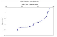
    Sound Velocity Profiles (SVP): Fourteen sound velocity casts were collected at various intervals during the USGS cruise 07011 using an Applied Microsystems SV Plus v2 instrument (see <http://www.appliedmicrosystems.com/products/productDetails.aspx?id=1> for details). Sound velocity profiles (SVP) were generally collected at the eastern and western ends of the survey area, corresponding to the start and/or end of geophysical line data collection. This procedure was primarily followed to coordinate collection of SVP casts with the beginning or end of trackline. This was acceptable because only small variations in the speed of sound were noted throughout the survey area and negligible refraction artifacts were visible within the swath bathymetric data.
  2. How were the data generated, processed, and modified?
    Date: 2007 (process 1 of 6)
    Fourteen sound velocity casts were collected at various intervals during the USGS cruise 07011 using an Applied Microsystems SV Plus v2 instrument (see <http://www.appliedmicrosystems.com/products/productDetails.aspx?id=1> for details). Sound velocity profiles (SVP) were generally collected at the eastern and western ends of the survey area, corresponding to the start and/or end of geophysical line data collection. This procedure was primarily followed to coordinate collection of SVP casts with the beginning or end of trackline. This was acceptable because only small variations in the speed of sound were noted throughout the survey area and negligible refraction artifacts were visible within the swath bathymetric data.
    At each pre-defined station (i.e. location), the SV plus v2 was slowly lowered to the seafloor using a small shipboard winch. The SV plus v2 was monitored by a member of the science party and as the instrument made contact with the seafloor, the position (i.e. location) was recorded in the lab using HYPACK navigation software. The position was then manually recorded within the cruise log and SWATHplus acquisition software. Upon recovery, the SV plus was connected to an onboard computer via serial port in order to download data using the SV plus v2 communications software, SmartTalk.
    Software: SV plus v2, SmartTalk (no version) Person who carried out this activity:
    Jane Denny
    U.S. Geological Survey
    Geologist
    384 Woods Hole Rd.
    Woods Hole, MA

    (508) 548-8700x2311 (voice)
    5084572310 (FAX)
    jdenny@usgs.gov
    Date: 2007 (process 2 of 6)
    The data were then exported in comma-separated value format and opened within Microsoft Excel. The files were saved in Microsoft Excel format (*.xls). Graphs of the sound velocity profile (Depth vs. speed of sound) at each station were created within Microsoft Excel and saved within the spreadsheet and as PDF files. The files were then opened using Adobe Photoshop CS3 and exported as JPEG images.
    Software: Microsoft Excel 2004; Adobe Photoshop CS3 (version 10.0.1) Person who carried out this activity:
    Jane Denny
    U.S. Geological Survey
    Geologist
    384 Woods Hole Rd.
    Woods Hole, MA

    (508) 548-8700x2311 (voice)
    5084572310 (FAX)
    jdenny@usgs.gov
    Date: 20-Oct-2017 (process 3 of 6)
    Edits to the metadata were made to fix any errors that MP v 2.9.36 flagged. This is necessary to enable the metadata to be successfully harvested for various data catalogs. In some cases, this meant adding text "Information unavailable" or "Information unavailable from original metadata" for those required fields that were left blank. Other minor edits were probably performed (title, publisher, publication place, etc.). Reordered the links in the identification section so a landing page link is first. Attempted to modify http to https where appropriate. The source information was incomplete and had to be modified to meet the standard. The distribution format name was modified in an attempt to be more consistent with other metadata files of the same data format. The metadata date (but not the metadata creator) was edited to reflect the date of these changes. The metadata available from a harvester may supersede metadata bundled within a download file. Compare the metadata dates to determine which metadata file is most recent. Person who carried out this activity:
    U.S. Geological Survey
    Attn: VeeAnn A. Cross
    Marine Geologist
    384 Woods Hole Road
    Woods Hole, MA

    508-548-8700 x2251 (voice)
    508-457-2310 (FAX)
    vatnipp@usgs.gov
    Date: 20-Jul-2018 (process 4 of 6)
    USGS Thesaurus keywords added to the keyword section. Person who carried out this activity:
    U.S. Geological Survey
    Attn: VeeAnn A. Cross
    Marine Geologist
    384 Woods Hole Road
    Woods Hole, MA

    508-548-8700 x2251 (voice)
    508-457-2310 (FAX)
    vatnipp@usgs.gov
    Date: 18-Nov-2019 (process 5 of 6)
    Crossref DOI link was added as the first link in the metadata. Person who carried out this activity:
    U.S. Geological Survey
    Attn: VeeAnn A. Cross
    Marine Geologist
    384 Woods Hole Road
    Woods Hole, MA

    508-548-8700 x2251 (voice)
    508-457-2310 (FAX)
    vatnipp@usgs.gov
    Date: 08-Sep-2020 (process 6 of 6)
    Added keywords section with USGS persistent identifier as theme keyword. Person who carried out this activity:
    U.S. Geological Survey
    Attn: VeeAnn A. Cross
    Marine Geologist
    384 Woods Hole Road
    Woods Hole, MA

    508-548-8700 x2251 (voice)
    508-457-2310 (FAX)
    vatnipp@usgs.gov
  3. What similar or related data should the user be aware of?

How reliable are the data; what problems remain in the data set?

  1. How well have the observations been checked?
  2. How accurate are the geographic locations?
    Real-Time Kinematic (RTK) navigation data were collected using an Ashtech Z-Extreme receiver, mounted on the SWATHplus sidemount and recorded using navigation software from HYPACK, Inc (<http://www.hypack.com/new/>). RTK provides accuracies on the order of 10s of centimeters (<http://www.navcen.uscg.gov/>). However, the horizontal and vertical offsets between the hand-winch used to deploy the SV plus v2 sound velocity profiler and the RTK antenna on the SWATHplus sidemount were not accounted for in determining the location of the sound velocity profiler. Thus, the horizontal accuracy of the sound velocity locations is considered to be +/- 10 meters.
  3. How accurate are the heights or depths?
  4. Where are the gaps in the data? What is missing?
    All sound velocity profiles collected during USGS Cruise 07011 are included in the downloadable WinZip file.
  5. How consistent are the relationships among the observations, including topology?
    All sound velocity profiles were acquired with the same instrument during the course of USGS Cruise 07011; an Applied Microsystems SV plus v2.

How can someone get a copy of the data set?

Are there legal restrictions on access or use of the data?
Access_Constraints None
Use_Constraints Public domain data from the U.S. Government are freely redistributable with proper metadata and source attribution. Please recognize the U.S. Geological Survey as the originator of the dataset.
  1. Who distributes the data set? (Distributor 1 of 1)
    Jane Denny
    U.S. Geological Survey
    Geologist
    384 Woods Hole Rd.
    Woods Hole, MA

    (508) 548-8700x2311 (voice)
    5084572310 (FAX)
    jdenny@usgs.gov
  2. What's the catalog number I need to order this data set? Downloadable Data
  3. What legal disclaimers am I supposed to read?
    Neither the U.S. Government, the Department of the Interior, nor the USGS, nor any of their employees, contractors, or subcontractors, make any warranty, express or implied, nor assume any legal liability or responsibility for the accuracy, completeness, or usefulness of any information, apparatus, product, or process disclosed, nor represent that its use would not infringe on privately owned rights. The act of distribution shall not constitute any such warranty, and no responsibility is assumed by the USGS in the use of these data or related materials.
    Any use of trade, product, or firm names is for descriptive purposes only and does not imply endorsement by the U.S. Government.
  4. How can I download or order the data?
  5. What hardware or software do I need in order to use the data set?
    These data can be viewed with any image viewing software.

Who wrote the metadata?

Dates:
Last modified: 18-Mar-2024
Metadata author:
U.S. Geological Survey
Attn: Jane F. Denny
Geologist
384 Woods Hole Road
Woods Hole, MA
USA

508-548-8700 x2311 (voice)
508-457-2310 (FAX)
whsc_data_contact@usgs.gov
Contact_Instructions:
The metadata contact email address is a generic address in the event the person is no longer with USGS. (updated on 20240318)
Metadata standard:
FGDC Content Standards for Digital Geospatial Metadata (FGDC-STD-001-1998)

This page is <https://cmgds.marine.usgs.gov/catalog/whcmsc/open_file_report/ofr2008-1288/svp_jpg.faq.html>
Generated by mp version 2.9.51 on Mon Mar 25 16:05:27 2024