Interpreted Distribution of the Axes of Fluvially-Cut Late Pleistocene Channels Buried Beneath Edgartown Harbor, Massachusetts, in Geographic, WGS84 (H11346_BCHANNELS.SHP)

Metadata also available as - [Questions & Answers] - [Parseable text] - [XML]

Metadata:

Identification_Information:
Citation:
Citation_Information:
Originator: U.S. Geological Survey
Publication_Date: 2009
Title:
Interpreted Distribution of the Axes of Fluvially-Cut Late Pleistocene Channels Buried Beneath Edgartown Harbor, Massachusetts, in Geographic, WGS84 (H11346_BCHANNELS.SHP)
Edition: 1.0
Geospatial_Data_Presentation_Form: vector digital data
Series_Information:
Series_Name: Open-File Report
Issue_Identification: 2009-1001
Publication_Information:
Publication_Place: Woods Hole Coastal and Marine Science Center, Woods Hole, MA
Publisher: U.S. Geological Survey, Coastal and Marine Geology Program
Online_Linkage: https://doi.org/10.3133/ofr20091001
Online_Linkage: Online_Linkage: http://pubs.usgs.gov/of/2009/1001/html/catalog.html
Larger_Work_Citation:
Citation_Information:
Originator: L.J. Poppe
Originator: K.Y. McMullen
Originator: D.S. Foster
Originator: D.S. Blackwood
Originator: S.J. Williams
Originator: S.D. Ackerman
Originator: M.S. Moser
Originator: K.A. Glomb
Publication_Date: 2010
Title:
Geological Interpretation of the Sea Floor Offshore of Edgartown, Massachusetts
Edition: 1.0
Series_Information:
Series_Name: Open-File Report
Issue_Identification: 2009-1001
Publication_Information:
Publication_Place: Reston, VA
Publisher: U.S. Geological Survey
Other_Citation_Details: 1 DVD-ROM
Online_Linkage: http://pubs.usgs.gov/of/2009/1001/
Description:
Abstract:
The U.S. Geological Survey (USGS), in cooperation with the National Oceanic and Atmospheric Administration (NOAA) and the Massachusetts Office of Coastal Zone Management (MA CZM), is producing detailed geologic maps of the coastal sea floor. Imagery, originally collected by NOAA for charting purposes, provides a fundamental framework for research and management activities along this part of the Massachusetts coastline, shows the composition and terrain of the seabed, and provides information on sediment transport and benthic habitat. Interpretive data layers were derived from the combined single-beam and multibeam echo-sounder data and sidescan-sonar data collected in the vicinity of Edgartown Harbor, Massachusetts. During August 2008 seismic-reflection profiles (Boomer and Chirp) were acquired, and during September 2008 bottom photographs and surficial sediment data were acquired as part of two ground-truth reconnaissance surveys.
Purpose:
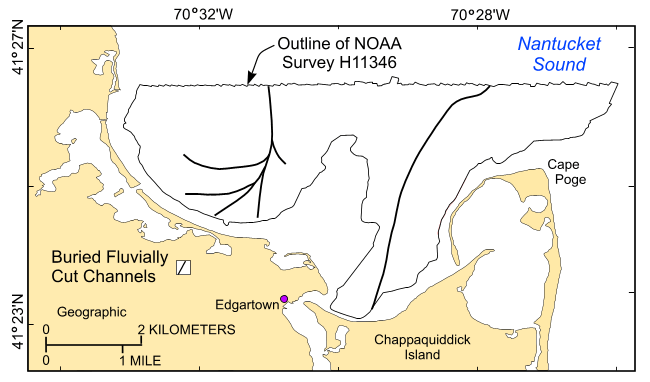
To release a data layer showing the interpreted distribution of the axes of fluvially-cut late Pleistocene channels buried within the NOAA survey H11346 area based on seismic data collected during USGS survey RAFA08034 in Edgartown Harbor, Massachusetts, in a geographic, WGS84 coordinate system.
Time_Period_of_Content:
Time_Period_Information:
Single_Date/Time:
Calendar_Date: 20080819
Time_of_Day: 20080820
Currentness_Reference: ground condition
Status:
Progress: Complete
Maintenance_and_Update_Frequency: None planned
Spatial_Domain:
Bounding_Coordinates:
West_Bounding_Coordinate: -70.537221
East_Bounding_Coordinate: -70.464040
North_Bounding_Coordinate: 41.440999
South_Bounding_Coordinate: 41.386741
Keywords:
Theme:
Theme_Keyword_Thesaurus: USGS Metadata Identifier
Theme_Keyword: USGS:fcaf808a-fe75-47bd-8454-422cc79f5e44
Theme:
Theme_Keyword_Thesaurus: None
Theme_Keyword: U.S. Geological Survey
Theme_Keyword: USGS
Theme_Keyword: Woods Hole Coastal and Marine Science Center
Theme_Keyword: Buried Channels
Theme_Keyword: Coastal and Marine Geology Program
Theme_Keyword: CMGP
Theme_Keyword: WHCMSC
Theme_Keyword: NOAA Survey H11346
Theme_Keyword: H11346
Theme_Keyword: National Oceanic and Atmospheric Administration
Theme_Keyword: NOAA
Theme_Keyword: Field Activity Number 08034
Theme_Keyword: ESRI shapefile
Theme_Keyword: channels
Theme_Keyword: fluvially cut
Theme_Keyword: late Pleistocene
Theme_Keyword: Open-File Report 2009-1001
Theme_Keyword: OFR 2009-1001
Theme_Keyword: line
Theme_Keyword: Chirp
Theme_Keyword: Knudsen
Theme_Keyword: Boomer
Theme_Keyword: seismic profiles
Theme_Keyword: interpretation
Theme:
Theme_Keyword_Thesaurus: ISO 19115 Topic Category
Theme_Keyword: geoscientificInformation
Theme_Keyword: oceans
Theme_Keyword: location
Theme:
Theme_Keyword_Thesaurus: USGS Thesaurus
Theme_Keyword: scientific interpretation
Theme_Keyword: geologic structure
Theme_Keyword: geospatial datasets
Theme_Keyword: marine geology
Place:
Place_Keyword_Thesaurus: None
Place_Keyword: Massachusetts
Place_Keyword: Nantucket Sound
Place_Keyword: Martha's Vineyard
Place_Keyword: U.S. East Coast
Place_Keyword: United States
Place_Keyword: North America
Place_Keyword: Atlantic Ocean
Place_Keyword: Edagrtown Harbor
Place_Keyword: Edgartown
Place_Keyword: Cape Poge
Place_Keyword: Dukes County
Place_Keyword: Chappaqiuddick Island
Access_Constraints: None
Use_Constraints:
The interpretation was completed at map scales less than 1:10,000, and is not intended for use smaller map scales. Public domain data from the U.S. Government are freely redistributable with proper metadata and source attribution. Please recognize the U.S. Geological Survey (USGS) as the source of this information.
Point_of_Contact:
Contact_Information:
Contact_Organization_Primary:
Contact_Organization: U.S. Geological Survey
Contact_Person: Larry Poppe
Contact_Position: Geologist
Contact_Address:
Address_Type: mailing and physical address
Address: 384 Woods Hole Road
City: Woods Hole
State_or_Province: MA
Postal_Code: 02543-1598
Contact_Voice_Telephone: 508-548-8700 x2314
Contact_Facsimile_Telephone: 508-457-2310
Contact_Electronic_Mail_Address: lpoppe@usgs.gov
Browse_Graphic:
Browse_Graphic_File_Name: Browse_Graphic_File_Description:
Thumbnail image showing the interpreted distribution of the axes of buried channels within NOAA survey H11346
Browse_Graphic_File_Type: GIF
Native_Data_Set_Environment:
Microsoft Windows XP Version 5.1 (Build 2600) Service Pack 3; ESRI ArcCatalog 9.2.6.1500
Cross_Reference:
Citation_Information:
Originator: Poppe, L.J.
Originator: Ackerman, S.D.
Originator: Foster, D.S.
Originator: Blackwood, D.S.
Originator: Butman, B.
Originator: Moser, M.S.
Originator: Stewart, H.F.
Publication_Date: 2007
Title:
Sea-floor character and sedimentary processes of Quicks Hole, Elizabeth Islands, Massachusetts
Edition: 1.0
Series_Information:
Series_Name: Open-File Report
Issue_Identification: 2006-1357
Publication_Information:
Publication_Place: Reston, VA
Publisher: U.S. Geological Survey
Online_Linkage: http://pubs.usgs.gov/of/2006/1357/
Cross_Reference:
Citation_Information:
Originator: Poppe, L.J.
Originator: Ackerman, S.D.
Originator: Foster, D.S.
Originator: Blackwood, D.S.
Originator: Williams, S.J.
Originator: Moser, M.S.
Originator: Stewart, H.F.
Originator: Glomb, K.A.
Publication_Date: 2007
Title:
Sea-floor character and sedimentary processes of Great Round Shoal Channel, offshore Massachusetts
Edition: 1.0
Series_Information:
Series_Name: Open-File Report
Issue_Identification: 2007-1138
Publication_Information:
Publication_Place: Reston, VA
Publisher: U.S. Geological Survey
Online_Linkage: http://pubs.usgs.gov/of/2007/1138/
Cross_Reference:
Citation_Information:
Originator: Poppe, L.J.
Originator: McMullen, K.Y.
Originator: Foster, D.S.
Originator: Blackwood, D.S.
Originator: Williams, S.J.
Originator: Ackerman, S.D.
Originator: Barnum, S.R.
Originator: Brennan, R.T.
Publication_Date: 2008
Title:
Sea-floor character and sedimentary processes in the vicinity of Woods Hole, Massachusetts
Edition: 1.0
Series_Information:
Series_Name: Open-File Report
Issue_Identification: 2008-1004
Publication_Information:
Publication_Place: Reston, VA
Publisher: U.S. Geological Survey
Online_Linkage: http://pubs.usgs.gov/of/2008/1004/
Data_Quality_Information:
Logical_Consistency_Report:
No additional checks for consistency were performed on this data.
Completeness_Report:
All collected data were processed and used to produce this dataset.
Positional_Accuracy:
Horizontal_Positional_Accuracy:
Horizontal_Positional_Accuracy_Report:
Navigation was by differential GPS. Ship's antenna was offset form the Chirp system by less than 5 m and from Boomer system by less than 20 m. Interpretation good to 1:24,000.
Lineage:
Source_Information:
Source_Citation:
Citation_Information:
Originator:
The source information was incomplete and had to be modified to meet the standard. Assumed to be USGS.
Publication_Date: unknown
Title:
The source information was incomplete and had to be modified to meet the standard.
Type_of_Source_Media: DVD-ROM
Source_Time_Period_of_Content:
Time_Period_Information:
Range_of_Dates/Times:
Beginning_Date: 20080819
Ending_Date: 20080820
Source_Currentness_Reference: ground condition
Source_Citation_Abbreviation:
The source information was incomplete and had to be modified to meet the standard.
Source_Contribution:
The original Boomer and Chirp seicmic data acquired during USGS survey RAFA08034.
Process_Step:
Process_Description:
The shot-point navigation of the Chirp and Boomer subbottom seismic profile lines collected from this survey area during USGS cruise rafa08034 were imported into the ArcView 3.3 GIS project view. Channel axis locations were interpreted on the profiles and corresponding shot points were calculated. An ESRI line shapefile using ArcView 3.3 was produced and preliminary lines were drawn. The lines were then adjusted to match the proper shot points on the intersecting seismic lines and manually smoothed.
Source_Used_Citation_Abbreviation: rafa08034_kelnav.shp
Source_Used_Citation_Abbreviation: rafa08034_boomernav.shp
Process_Date: 2009
Source_Produced_Citation_Abbreviation: h11346_bchannel.shp
Process_Contact:
Contact_Information:
Contact_Person_Primary:
Contact_Person: Larry Poppe
Contact_Organization: U.S. Geological Survey
Contact_Position: Geologist
Contact_Address:
Address_Type: mailing and physical address
Address: 384 Woods Hole Road
City: Woods Hole
State_or_Province: MA
Postal_Code: 02543-1598
Contact_Voice_Telephone: 508-548-8700 x2314
Contact_Facsimile_Telephone: 508-457-2310
Contact_Electronic_Mail_Address: lpoppe@usgs.gov
Process_Step:
Process_Description:
ArcGIS 9.2 was used to define the projection of the ESRI shapefile and to create the .prj file.
Source_Used_Citation_Abbreviation: h11346_interp.shp
Process_Date: 2008
Source_Produced_Citation_Abbreviation: h11346_interp.prj
Process_Contact:
Contact_Information:
Contact_Person_Primary:
Contact_Person: Larry Poppe
Contact_Organization: U.S. Geological Survey
Contact_Position: Geologist
Contact_Address:
Address_Type: mailing and physical address
Address: 384 Woods Hole Road
City: Woods Hole
State_or_Province: MA
Postal_Code: 02536
Country: USA
Contact_Voice_Telephone: 508-548-8700 x2314
Contact_Facsimile_Telephone: 508-457-2310
Contact_Electronic_Mail_Address: lpoppe@usgs.gov
Process_Step:
Process_Description:
Edits to the metadata were made to fix any errors that MP v 2.9.30 flagged. This is necessary to enable the metadata to be successfully harvested for various data catalogs. In some cases, this meant adding text "Information unavailable" or "Information unavailable from original metadata" for those required fields that were left blank. Other minor edits were probably performed (title, publisher, publication place, etc.). This file had a source contribution, but no other source information. This information had to be modified to meet the standard. The metadata date (but not the metadata creator) was edited to reflect the date of these changes. The metadata available from a harvester may supersede metadata bundled within a download file. Compare the metadata dates to determine which metadata file is most recent.
Process_Date: 20160303
Process_Contact:
Contact_Information:
Contact_Organization_Primary:
Contact_Organization: U.S. Geological Survey
Contact_Person: VeeAnn A. Cross
Contact_Position: Marine Geologist
Contact_Address:
Address_Type: mailing and physical address
Address: 384 Woods Hole Rd.
City: Woods Hole
State_or_Province: MA
Postal_Code: 02543
Contact_Voice_Telephone: 508-548-8700 x2251
Contact_Facsimile_Telephone: 508-457-2310
Contact_Electronic_Mail_Address: vatnipp@usgs.gov
Process_Step:
Process_Description: USGS Thesaurus keywords added to the keyword section.
Process_Date: 20180720
Process_Contact:
Contact_Information:
Contact_Organization_Primary:
Contact_Organization: U.S. Geological Survey
Contact_Person: VeeAnn A. Cross
Contact_Position: Marine Geologist
Contact_Address:
Address_Type: Mailing and Physical
Address: 384 Woods Hole Road
City: Woods Hole
State_or_Province: MA
Postal_Code: 02543-1598
Contact_Voice_Telephone: 508-548-8700 x2251
Contact_Facsimile_Telephone: 508-457-2310
Contact_Electronic_Mail_Address: vatnipp@usgs.gov
Process_Step:
Process_Description: Crossref DOI link was added as the first link in the metadata.
Process_Date: 20191118
Process_Contact:
Contact_Information:
Contact_Organization_Primary:
Contact_Organization: U.S. Geological Survey
Contact_Person: VeeAnn A. Cross
Contact_Position: Marine Geologist
Contact_Address:
Address_Type: Mailing and Physical
Address: 384 Woods Hole Road
City: Woods Hole
State_or_Province: MA
Postal_Code: 02543-1598
Contact_Voice_Telephone: 508-548-8700 x2251
Contact_Facsimile_Telephone: 508-457-2310
Contact_Electronic_Mail_Address: vatnipp@usgs.gov
Process_Step:
Process_Description:
Added keywords section with USGS persistent identifier as theme keyword.
Process_Date: 20200908
Process_Contact:
Contact_Information:
Contact_Organization_Primary:
Contact_Organization: U.S. Geological Survey
Contact_Person: VeeAnn A. Cross
Contact_Position: Marine Geologist
Contact_Address:
Address_Type: Mailing and Physical
Address: 384 Woods Hole Road
City: Woods Hole
State_or_Province: MA
Postal_Code: 02543-1598
Contact_Voice_Telephone: 508-548-8700 x2251
Contact_Facsimile_Telephone: 508-457-2310
Contact_Electronic_Mail_Address: vatnipp@usgs.gov
Spatial_Data_Organization_Information:
Direct_Spatial_Reference_Method: Vector
Point_and_Vector_Object_Information:
SDTS_Terms_Description:
SDTS_Point_and_Vector_Object_Type: String
Point_and_Vector_Object_Count: 6
Spatial_Reference_Information:
Horizontal_Coordinate_System_Definition:
Geographic:
Latitude_Resolution: 0.000001
Longitude_Resolution: 0.000001
Geographic_Coordinate_Units: Decimal degrees
Geodetic_Model:
Horizontal_Datum_Name: D_WGS_1984
Ellipsoid_Name: WGS_1984
Semi-major_Axis: 6378137.000000
Denominator_of_Flattening_Ratio: 298.257224
Entity_and_Attribute_Information:
Detailed_Description:
Entity_Type:
Entity_Type_Label: h11346_bchannels
Entity_Type_Definition: Shapefile Attribute Table
Entity_Type_Definition_Source: ESRI
Attribute:
Attribute_Label: FID
Attribute_Definition: Internal feature number.
Attribute_Definition_Source: ESRI
Attribute_Domain_Values:
Unrepresentable_Domain:
Sequential unique whole numbers that are automatically generated.
Attribute:
Attribute_Label: Shape
Attribute_Definition: Feature geometry.
Attribute_Definition_Source: ESRI
Attribute_Domain_Values:
Unrepresentable_Domain: Coordinates defining the features.
Attribute:
Attribute_Label: ID
Attribute_Definition: Internal feature number
Attribute_Definition_Source: ESRI
Attribute_Domain_Values:
Unrepresentable_Domain: Information unavailable from the original metadata.
Overview_Description:
Entity_and_Attribute_Overview:
A shapefile containing interpreted distribution of fluvially-cut late Pleistocene channels buried beneath the seafloor of Edgartown Harbor.
Entity_and_Attribute_Detail_Citation: U.S. Geological Survey
Distribution_Information:
Distributor:
Contact_Information:
Contact_Person_Primary:
Contact_Person: Larry Poppe
Contact_Organization: U.S. Geological Survey
Contact_Position: Geologist
Contact_Address:
Address_Type: mailing and physical address
Address: 384 Woods Hole Road
City: Woods Hole
State_or_Province: MA
Postal_Code: 02543-1598
Contact_Voice_Telephone: 508-548-8700 x2314
Contact_Facsimile_Telephone: 508-457-2310
Contact_Electronic_Mail_Address: lpoppe@usgs.gov
Resource_Description: Downloadable Data
Distribution_Liability:
Neither the U.S. Government, the Department of the Interior, nor the USGS, nor the National Oceanic and Atmospheric Administration (NOAA), nor any of their employees, contractors, or subcontractors, make any warranty, express or implied, nor assume any legal liability or responsibility for the accuracy, completeness, or usefulness of any information, apparatus, product, or process disclosed, nor represent that its use would not infringe on privately owned rights. The act of distribution shall not constitute any such warranty, and no responsibility is assumed by the USGS or NOAA in the use of these data or related materials. Any use of trade, product, or firm names is for descriptive purposes only and does not imply endorsement by the U.S. Government.
Standard_Order_Process:
Digital_Form:
Digital_Transfer_Information:
Format_Name: SHP
Format_Version_Number: ArcGIS 9.2
Format_Specification: ESRI line shapefile
Format_Information_Content:
A zip file containing the geospatial data, metadata, and browse graphic.
File_Decompression_Technique: zip archive
Transfer_Size: 0.160
Digital_Transfer_Option:
Online_Option:
Computer_Contact_Information: Access_Instructions: Data are downloadable via the World Wide Web (WWW).
Offline_Option:
Offline_Media: DVD-ROM
Recording_Capacity:
Recording_Density: 4.75
Recording_Density_Units: Gbytes
Recording_Format: UDF
Fees: None
Technical_Prerequisites:
The user must be capable of uncompressing WinZip files. Also, these data are available in Environmental Systems Research Institute (ESRI) shapefile format. The user must have ArcGIS or ArcView 3.0 or greater software to read and process the data file. In lieu of ArcView or ArcGIS, the user may utilize another GIS application package capable of importing data. A free data viewer, ArcExplorer, capable of displaying the data is available from ESRI at www.esri.com.
Available_Time_Period:
Time_Period_Information:
Single_Date/Time:
Calendar_Date: 2009
Metadata_Reference_Information:
Metadata_Date: 20211116
Metadata_Contact:
Contact_Information:
Contact_Organization_Primary:
Contact_Organization: U.S. Geological Survey
Contact_Person: Larry Poppe
Contact_Position: Geologist
Contact_Address:
Address_Type: mailing and physical address
Address: 384 Woods Hole Road
City: Woods Hole
State_or_Province: MA
Postal_Code: 02543-1598
Contact_Voice_Telephone: 508-548-8700 x2314
Contact_Facsimile_Telephone: 508-457-2310
Contact_Electronic_Mail_Address: whsc_data_contact@usgs.gov
Contact_Instructions:
The metadata contact email address is a generic address in the event the metadata contact is no longer with the USGS or the email is otherwise invalid.
Metadata_Standard_Name: FGDC Content Standards for Digital Geospatial Metadata
Metadata_Standard_Version: FGDC-STD-001-1998
Metadata_Time_Convention: local time
Metadata_Access_Constraints: None
Metadata_Use_Constraints: None

This page is <https://cmgds.marine.usgs.gov/catalog/whcmsc/open_file_report/ofr2009-1001/h11346_bchannels.shp.html>
Generated by mp version 2.9.50 on Tue Nov 16 10:06:37 2021