Citation:
Description:
Abstract:
During 1980, a Uniboom seismic-reflection survey was conducted by the U.S. Geological Survey (USGS) in western Rhode Island Sound aboard the Research Vessel NeechoThe cruise consisted of 2 legs and had a total of 8 survey days. Data from this survey were recorded in analog form and archived at the USGS. As a result of recent interest in the geology of Rhode Island Sound and in an effort to make the data more readily accessible while preserving the original paper records, the seismic data from this cruise were scanned and converted to TIFF and PNG images and SEG-Y data files. In order to scan the lines, some of the paper records were cut and scanned in sections. These sections are labeled with lower-case letters and differ from the names of lines in the logbook. Some SEG-Y files were further divided in order for each file to contain continuous data collected at the same ship speed; these line segments have been labeled _1, _2, or _3 after the section label. Navigation data were converted from LORAN-C time delays to latitudes and longitudes that are available in ESRI shapefile format and as eastings and northings in space-delimited text format.
Purpose:
This data set contains grayscale seismic-reflection images in PNG format from the seismic-reflection data set collected aboard the R/V NEECHO during a 1980 geophysical cruise in western Rhode Island Sound. The seismic data provide useful information about the framework geology in this region. This metadata describes the PNG files as a whole.
Time_Period_of_Content:
Time_Period_Information:
Range_of_Dates/Times:
Beginning_Date: 19800709
Ending_Date: 19801002
Currentness_Reference:
ground condition of two separate time spans: 19800709 to 19800717 and 19800929 to 19801002.
Status:
Progress: Complete
Maintenance_and_Update_Frequency: None planned
Spatial_Domain:
Bounding_Coordinates:
West_Bounding_Coordinate: -71.569208
East_Bounding_Coordinate: -71.130113
North_Bounding_Coordinate: 41.485329
South_Bounding_Coordinate: 41.191382
Keywords:
Theme:
Theme_Keyword_Thesaurus: USGS Metadata Identifier
Theme_Keyword: USGS:6437b49c-66a8-49d3-a0bd-25fafa2ce090
Theme:
Theme_Keyword_Thesaurus: None
Theme_Keyword: U.S. Geological Survey
Theme_Keyword: USGS
Theme_Keyword: Coastal and Marine Geology Program
Theme_Keyword: CMGP
Theme_Keyword: Woods Hole Science Center
Theme_Keyword: WHSC
Theme_Keyword: R/V Neecho
Theme_Keyword: high-resolution seismic
Theme_Keyword: geophysical data
Theme_Keyword: Uniboom seismic reflection
Theme_Keyword: PNG
Theme_Keyword: OFR 2009-1002
Theme_Keyword: Open-File Report 2009-1002
Theme_Keyword: Cruise NECH80-1
Theme_Keyword: Field activity number 80016
Theme:
Theme_Keyword_Thesaurus: ISO 19115 Topic Category
Theme_Keyword: geoscientificInformation
Theme_Keyword: oceans
Theme:
Theme_Keyword_Thesaurus: USGS Thesaurus
Theme_Keyword: sub-bottom profiling
Theme_Keyword: image collections
Theme_Keyword: marine geophysics
Place:
Place_Keyword_Thesaurus: None
Place_Keyword: Rhode Island Sound
Place_Keyword: Rhode Island
Place_Keyword: U.S. East Coast
Place_Keyword: North America
Place_Keyword: United States
Place_Keyword: Atlantic Ocean
Place_Keyword: North Atlantic Ocean
Place_Keyword: northeast United States
Access_Constraints: None
Use_Constraints:
Public domain data are freely redistributable with proper metadata and source attribution. Please recognize the U.S. Geological Survey as the originator of this dataset.
Point_of_Contact:
Contact_Information:
Contact_Person_Primary:
Contact_Person: Katherine McMullen
Contact_Organization: U.S. Geological Survey
Contact_Position: Sediment Lab Technician
Contact_Address:
Address_Type: mailing and physical address
Address: 384 Woods Hole Road
City: Woods Hole
State_or_Province: MA
Postal_Code: 02543
Country: USA
Contact_Voice_Telephone: (508) 548-8700 x2277
Contact_Facsimile_Telephone: (508) 457-2310
Contact_Electronic_Mail_Address: [email protected]
Browse_Graphic:
Browse_Graphic_File_Name:
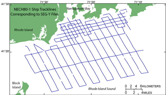
Browse_Graphic_File_Description: Browse image of seismic-line locations from cruise NECH80-1.
Browse_Graphic_File_Type: GIF
Native_Data_Set_Environment:
Microsoft Windows XP Version 5.1 (Build 2600) Service Pack 3; ESRI ArcCatalog 9.2.6.1500
Cross_Reference:
Citation_Information:
Originator: S.W. Needell
Originator: C.J. O'Hara
Originator: H.J. Knebel
Publication_Date: 1983
Title:
Maps showing geology and shallow structure of western Rhode Island Sound, Rhode Island
Geospatial_Data_Presentation_Form: map
Series_Information:
Series_Name: Miscellaneous Field Studies Map
Issue_Identification: MF-1537
Publication_Information:
Publication_Place: Reston, VA
Publisher: U.S. Geological Survey
Online_Linkage: https://pubs.usgs.gov/mf/1983/mf-1537/