One-Minute Shot Point Navigation for Seismic-Reflection Data Collected in 1975 from Eastern Rhode Island Sound; Formatted for Use With Landmark (A75_6_SHOTNAV.TXT)

Metadata also available as - [Outline] - [Parseable text] - [XML]

Frequently anticipated questions:


What does this data set describe?

Title:
One-Minute Shot Point Navigation for Seismic-Reflection Data Collected in 1975 from Eastern Rhode Island Sound; Formatted for Use With Landmark (A75_6_SHOTNAV.TXT)
Abstract:
During 1975, the U.S. Geological Survey (USGS) conducted a seismic-reflection survey utilizing Uniboom seismics in eastern Rhode Island Sound aboard the Research Vessel Asterias. This cruise totalled 8 survey days. Data from this survey were recorded in analog form and archived at the USGS. Due to recent interest in the geology of Rhode Island Sound and in an effort to make the data more readily accessible while preserving the original paper records, the seismic data from this cruise were scanned and converted to TIFF images and SEG-Y data files. Navigation data were converted from LORAN-C time delays to latitudes and longitudes, which are available in ESRI shapefile format and as eastings and northings in space-delimited text format.
  1. How might this data set be cited?
    U.S. Geological Survey, 2009, One-Minute Shot Point Navigation for Seismic-Reflection Data Collected in 1975 from Eastern Rhode Island Sound; Formatted for Use With Landmark (A75_6_SHOTNAV.TXT): Open-File Report 2009-1003, U.S. Geological Survey, Coastal and Marine Geology Program, Woods Hole Coastal and Marine Science Center, Woods Hole, MA.

    Online Links:

    This is part of the following larger work.

    McMullen, K.Y., Poppe, L.J., and Soderberg, N.K., 2009, Digital Seismic-Reflection Data from Eastern Rhode Island Sound and Vicinity, 1975-1980: Open-File Report 2009-1003, U.S. Geological Survey, Reston, VA.

    Online Links:

    Other_Citation_Details: 2 DVD-ROMs
  2. What geographic area does the data set cover?
    West_Bounding_Coordinate: -71.215370
    East_Bounding_Coordinate: -70.637272
    North_Bounding_Coordinate: 41.502251
    South_Bounding_Coordinate: 41.233566
  3. What does it look like?
    http://pubs.usgs.gov/of/2009/1003/data/nav/eris/a75_6_shotnav/a75_6_shotnav.gif (GIF)
    Browse image of 1-minute shot point navigation from cruise ASTR75-June.
  4. Does the data set describe conditions during a particular time period?
    Beginning_Date: 20-Jun-1975
    Ending_Date: 29-Jun-1975
    Currentness_Reference:
    ground condition
  5. What is the general form of this data set?
    Geospatial_Data_Presentation_Form: vector digital data
  6. How does the data set represent geographic features?
    1. How are geographic features stored in the data set?
      This is a Point data set. It contains the following vector data types (SDTS terminology):
      • Point
    2. What coordinate system is used to represent geographic features?
      Grid_Coordinate_System_Name: Universal Transverse Mercator
      Universal_Transverse_Mercator:
      UTM_Zone_Number: 19
      Transverse_Mercator:
      Scale_Factor_at_Central_Meridian: 0.999600
      Longitude_of_Central_Meridian: -69.000000
      Latitude_of_Projection_Origin: 0.000000
      False_Easting: 500000.000000
      False_Northing: 0.000000
      Planar coordinates are encoded using coordinate pair
      Abscissae (x-coordinates) are specified to the nearest 1
      Ordinates (y-coordinates) are specified to the nearest 1
      Planar coordinates are specified in meters
      The horizontal datum used is D_WGS_1984.
      The ellipsoid used is WGS_1984.
      The semi-major axis of the ellipsoid used is 6378137.000000.
      The flattening of the ellipsoid used is 1/298.257224.
  7. How does the data set describe geographic features?
    Entity_and_Attribute_Overview:
    Four values per record: Unique Line ID, Shot Number, Easting, and Northing. Eastings and northings are in UTM 19, WGS84. Lines are named using the following convention: a75_625Ab_1 signifies the data is from the R/V Asterias June 1975 cruise (ASTR75-June represented as a75_6), line 25A, section b, SEG-Y segment 1 (if SEG-Y line was cut due to belt changes).
    Entity_and_Attribute_Detail_Citation: U.S. Geological Survey

Who produced the data set?

  1. Who are the originators of the data set? (may include formal authors, digital compilers, and editors)
    • U.S. Geological Survey
  2. Who also contributed to the data set?
  3. To whom should users address questions about the data?
    Katherine McMullen
    U.S. Geological Survey
    Sediment Lab Technician
    384 Woods Hole Road
    Woods Hole, MA
    USA

    (508) 548-8700 x2277 (voice)
    (508) 457-2310 (FAX)
    kmcmullen@usgs.gov

Why was the data set created?

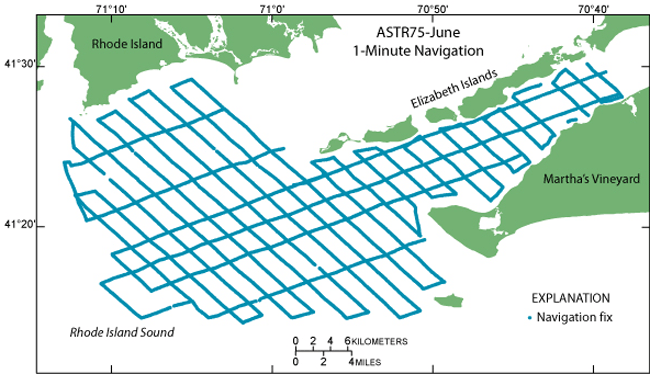
This data file contains the 1-minute shot point navigation collected aboard the R/V Asterias during a 1975 geophysical cruise in eastern Rhode Island Sound. It is meant to accompany the SEG-Y files. It is part of a digital version of a regional map showing the distribution of sub-bottom seismic profiles collected in Rhode Island Sound. The seismic data collected along these ship tracks can be used to provide useful information about the framework geology in this region.

How was the data set created?

  1. From what previous works were the data drawn?
    Cruise Log, R/V Asterias, SW Buzzards Bay, NE Rhode Island Sound, Vineyard Sound (source 1 of 1)
    U.S. Geological Survey, 1975, Cruise Log, R/V Asterias, SW Buzzards Bay, NE Rhode Island Sound, Vineyard Sound.

    Online Links:

    Type_of_Source_Media: log book
    Source_Contribution:
    LORAN-C navigation data were recorded during field work in eastern Rhode Island Sound. This data set contains the latitude and longitude coordinates converted from the LORAN-C time delays described in the a75_6nav_sort.shp metadata (http://pubs.usgs.gov/of/2009/1003/data/nav/eris/a75_6nav/a75_6nav.zip).
  2. How were the data generated, processed, and modified?
    Date: 2009 (process 1 of 6)
    An ANSI text file containing unique line identification, easting, northing, and shot number was exported from ArcMap 9.2 using XToolsPro Version 5.3 Export Table to Text. Person who carried out this activity:
    Jane Denny
    U.S. Geological Survey
    Geologist
    384 Woods Hole Road
    Woods Hole, MA
    USA

    (508) 548-8700 x2311 (voice)
    (508) 457-2310 (FAX)
    jdenny@usgs.gov
    Data sources used in this process:
    • a75_6_1minnav_sort.shp
    Data sources produced in this process:
    • a75_6_1minshotnav.txt
    Date: 2009 (process 2 of 6)
    The text file was transferred to a LINUX computer and converted from DOS to Unix using Dos2Unix command. An AWK script was used to reformat the text file as right justified fields with space delimiters in the order Unique Line ID, shot number, easting, and northing, in order to generate a format ready to import into the seismic interpretation package, Landmark Graphics, SeisWorks. The easting and northing values are rounded to the nearest meter. Person who carried out this activity:
    Jane Denny
    U.S. Geological Survey
    Geologist
    384 Woods Hole Road
    Woods Hole, MA
    USA

    (508) 548-8700 x2311 (voice)
    (508) 457-2310 (FAX)
    jdenny@usgs.gov
    Data sources used in this process:
    • a75_6_1minshotnav.txt
    Data sources produced in this process:
    • a75_6_shotnav.txt
    Date: 23-May-2016 (process 3 of 6)
    Edits to the metadata were made to fix any errors that MP v 2.9.32 flagged. This is necessary to enable the metadata to be successfully harvested for various data catalogs. In some cases, this meant adding text "Information unavailable" or "Information unavailable from original metadata" for those required fields that were left blank. Other minor edits were probably performed (title, publisher, publication place, etc.). The metadata date (but not the metadata creator) was edited to reflect the date of these changes. The metadata available from a harvester may supersede metadata bundled within a download file. Compare the metadata dates to determine which metadata file is most recent. Person who carried out this activity:
    U.S. Geological Survey
    Attn: VeeAnn A. Cross
    Marine Geologist
    384 Woods Hole Rd.
    Woods Hole, MA

    508-548-8700 x2251 (voice)
    508-457-2310 (FAX)
    vatnipp@usgs.gov
    Date: 20-Jul-2018 (process 4 of 6)
    USGS Thesaurus keywords added to the keyword section. Person who carried out this activity:
    U.S. Geological Survey
    Attn: VeeAnn A. Cross
    Marine Geologist
    384 Woods Hole Road
    Woods Hole, MA

    508-548-8700 x2251 (voice)
    508-457-2310 (FAX)
    vatnipp@usgs.gov
    Date: 18-Nov-2019 (process 5 of 6)
    Crossref DOI link was added as the first link in the metadata. Person who carried out this activity:
    U.S. Geological Survey
    Attn: VeeAnn A. Cross
    Marine Geologist
    384 Woods Hole Road
    Woods Hole, MA

    508-548-8700 x2251 (voice)
    508-457-2310 (FAX)
    vatnipp@usgs.gov
    Date: 08-Sep-2020 (process 6 of 6)
    Added keywords section with USGS persistent identifier as theme keyword. Person who carried out this activity:
    U.S. Geological Survey
    Attn: VeeAnn A. Cross
    Marine Geologist
    384 Woods Hole Road
    Woods Hole, MA

    508-548-8700 x2251 (voice)
    508-457-2310 (FAX)
    vatnipp@usgs.gov
  3. What similar or related data should the user be aware of?
    O'Hara, C.J., and Oldale, R.N., 1980, Maps showing geology and shallow structure of eastern Rhode Island Sound and Vineyard Sound, Massachusetts: U.S. Geological Survey Miscellaneous Field Studies Map MF-1186, U.S. Geological Survey, Reston, VA.

    Online Links:

    McMullen, K.Y., Poppe, L.J., and Soderberg, N.K., 2009, Digital Seismic-Reflection Data from Western Rhode Island Sound, 1980: Open-File Report 2009-1002, U.S. Geological Survey, Reston, VA.

    Online Links:


How reliable are the data; what problems remain in the data set?

  1. How well have the observations been checked?
    Attribute data were recorded by the science party and entered and checked by the compilers in a consistent manner.
  2. How accurate are the geographic locations?
    All navigation was done by LORAN-C and was manually recorded. The cruise used the Group Repetition Interval 9930 U.S. East Coast chain and recorded time delays from Cape Race, Newfoundland (X) and Dana, Ind. (Z) slave transmitters. Absolute accuracy is 185 to 463 m based on a link no longer available from http://www.navcen.uscg.gov/. The original link referred to the loran/handbook/h-book.htm (see Chapter III). A possible new link with similar information is available from: http://www.navcen.uscg.gov/pdf/loran/handbook/loran-c_users_handbook_entire.pdf.
  3. How accurate are the heights or depths?
  4. Where are the gaps in the data? What is missing?
    The logbook navigation for two points in the survey was determined to be incorrect and has been excluded from the data set (line 11b time 1945 and line 14 time 815). Navigation points are spaced at 1-minute intervals and at course changes or line events (start/end of line). Continuous navigation is not available.
  5. How consistent are the relationships among the observations, including topology?
    The layers were edited and processed in a consistent manner.

How can someone get a copy of the data set?

Are there legal restrictions on access or use of the data?
Access_Constraints: None
Use_Constraints:
Public domain data are freely redistributable with proper metadata and source attribution. Please recognize the U.S. Geological Survey as the originator of this dataset.
  1. Who distributes the data set? (Distributor 1 of 1)
    Lawrence Poppe
    U.S. Geological Survey
    Geologist
    384 Woods Hole Road
    Woods Hole, MA
    USA

    (508) 548-8700 x2314 (voice)
    (508) 457-2310 (FAX)
    lpoppe@usgs.gov
  2. What's the catalog number I need to order this data set? Downloadable Data: a75_6_shotnav.txt
  3. What legal disclaimers am I supposed to read?
    Neither the U.S. Government, the Department of the Interior, nor the USGS, nor any of their employees, contractors, or subcontractors, make any warranty, express or implied, nor assume any legal liability or responsibility for the accuracy, completeness, or usefulness of any information, apparatus, product, or process disclosed, nor represent that its use would not infringe on privately owned rights. The act of distribution shall not constitute any such warranty, and no responsibility is assumed by the USGS in the use of these data or related materials. Any use of trade, product, or firm names is for descriptive purposes only and does not imply endorsement by the U.S. Government.
  4. How can I download or order the data?
  5. What hardware or software do I need in order to use the data set?
    The user must have a program capable of uncompressing the WinZip 9.0 file, and of reading and processing the navigation text file (formatted to import into Landmark Graphics, SeisWorks).

Who wrote the metadata?

Dates:
Last modified: 16-Nov-2021
Metadata author:
U.S. Geological Survey
Attn: Katherine McMullen
Sediment Lab Technician
384 Woods Hole Road
Woods Hole, MA
USA

(508) 548-8700 x2277 (voice)
(508) 457-2310 (FAX)
whsc_data_contact@usgs.gov
Contact_Instructions:
The metadata contact email address is a generic address in the event the metadata contact is no longer with the USGS or the email is otherwise invalid.
Metadata standard:
FGDC Content Standards for Digital Geospatial Metadata (FGDC-STD-001-1998)

This page is <https://cmgds.marine.usgs.gov/catalog/whcmsc/open_file_report/ofr2009-1003/a75_6_shotnav.txt.faq.html>
Generated by mp version 2.9.50 on Tue Nov 16 10:06:37 2021