Grayscale Seismic-Reflection Images in PNG Format from Eastern Rhode Island Sound from 1975

Metadata also available as - [Questions & Answers] - [Parseable text] - [XML]

Metadata:

Identification_Information:
Citation:
Citation_Information:
Originator: U.S. Geological Survey
Publication_Date: 2009
Title:
Grayscale Seismic-Reflection Images in PNG Format from Eastern Rhode Island Sound from 1975
Edition: 1.0
Series_Information:
Series_Name: Open-File Report
Issue_Identification: 2009-1003
Publication_Information:
Publication_Place: Woods Hole Coastal and Marine Science Center, Woods Hole, MA
Publisher: U.S. Geological Survey, Coastal and Marine Geology Program
Online_Linkage: https://doi.org/10.3133/ofr20091003
Online_Linkage: https://pubs.usgs.gov/of/2009/1003/html/catalog.html
Online_Linkage: https://pubs.usgs.gov/of/2009/1003/DiskB/eris_png/
Online_Linkage: https://pubs.usgs.gov/of/2009/1003/html/eris_prof.html
Larger_Work_Citation:
Citation_Information:
Originator: K.Y. McMullen
Originator: L.J. Poppe
Originator: N.K. Soderberg
Publication_Date: 2009
Title:
Digital Seismic-Reflection Data from Eastern Rhode Island Sound and Vicinity, 1975-1980
Edition: 1.0
Series_Information:
Series_Name: Open-File Report
Issue_Identification: 2009-1003
Publication_Information:
Publication_Place: Reston, VA
Publisher: U.S. Geological Survey
Other_Citation_Details: 2 DVD-ROMs
Online_Linkage: https://pubs.usgs.gov/of/2009/1003/
Description:
Abstract:
During 1975, the U.S. Geological Survey (USGS) conducted a seismic-reflection survey utilizing Uniboom seismics in eastern Rhode Island Sound aboard the Research Vessel Asterias. This cruise totalled 8 survey days. Data from this survey were recorded in analog form and archived at the USGS. Due to recent interest in the geology of Rhode Island Sound and in an effort to make the data more readily accessible while preserving the original paper records, the seismic data from this cruise were scanned and converted to TIFF images and SEG-Y data files. Navigation data were converted from LORAN-C time delays to latitudes and longitudes, which are available in ESRI shapefile format and as eastings and northings in space-delimited text format.
Purpose:
This data set contains grayscale seismic-reflection images in PNG format from the seismic-reflection data set collected aboard the R/V Asterias during a 1975 geophysical cruise in eastern Rhode Island Sound. These images correspond to the SEG-Y files.The seismic data can be used to provide useful information about the framework geology in this region. This metadata describes the PNG files as a whole.
Time_Period_of_Content:
Time_Period_Information:
Range_of_Dates/Times:
Beginning_Date: 19750620
Ending_Date: 19750629
Currentness_Reference: ground condition
Status:
Progress: Complete
Maintenance_and_Update_Frequency: None planned
Spatial_Domain:
Bounding_Coordinates:
West_Bounding_Coordinate: -71.215370
East_Bounding_Coordinate: -70.637272
North_Bounding_Coordinate: 41.502251
South_Bounding_Coordinate: 41.233566
Keywords:
Theme:
Theme_Keyword_Thesaurus: USGS Metadata Identifier
Theme_Keyword: USGS:f2e9d35d-c59b-4d42-98fb-2c4c55ef4fea
Theme:
Theme_Keyword_Thesaurus: None
Theme_Keyword: U.S. Geological Survey
Theme_Keyword: USGS
Theme_Keyword: Coastal and Marine Geology Program
Theme_Keyword: CMGP
Theme_Keyword: Woods Hole Science Center
Theme_Keyword: WHSC
Theme_Keyword: R/V Asterias
Theme_Keyword: high-resolution seismic
Theme_Keyword: geophysical data
Theme_Keyword: Uniboom seismic reflection
Theme_Keyword: PNG image
Theme_Keyword: OFR 2009-1003
Theme_Keyword: Open-File Report 2009-1003
Theme_Keyword: Cruise ASTR75-June
Theme_Keyword: Field activity number 75011
Theme:
Theme_Keyword_Thesaurus: ISO 19115 Topic Category
Theme_Keyword: geoscientificInformation
Theme_Keyword: oceans
Theme:
Theme_Keyword_Thesaurus: USGS Thesaurus
Theme_Keyword: sub-bottom profiling
Theme_Keyword: image collections
Theme_Keyword: marine geophysics
Place:
Place_Keyword_Thesaurus: None
Place_Keyword: Northeast Rhode Island Sound
Place_Keyword: Rhode Island
Place_Keyword: U.S. East Coast
Place_Keyword: North America
Place_Keyword: United States
Place_Keyword: Atlantic Ocean
Place_Keyword: North Atlantic Ocean
Place_Keyword: northeast United States
Place_Keyword: Vineyard Sound
Place_Keyword: Massachusetts
Place_Keyword: Southwest Buzzards Bay
Place_Keyword: Westport Harbor
Place_Keyword: Cuttyhunk Island
Place_Keyword: No Mans Land
Place_Keyword: Marthas Vineyard
Access_Constraints: None
Use_Constraints:
Public domain data are freely redistributable with proper metadata and source attribution. Please recognize the U.S. Geological Survey as the originator of this dataset.
Point_of_Contact:
Contact_Information:
Contact_Person_Primary:
Contact_Person: Katherine McMullen
Contact_Organization: U.S. Geological Survey
Contact_Position: Sediment Lab Technician
Contact_Address:
Address_Type: mailing and physical address
Address: 384 Woods Hole Road
City: Woods Hole
State_or_Province: MA
Postal_Code: 02543
Country: USA
Contact_Voice_Telephone: (508) 548-8700 x2277
Contact_Facsimile_Telephone: (508) 457-2310
Contact_Electronic_Mail_Address: kmcmullen@usgs.gov
Browse_Graphic:
Browse_Graphic_File_Name: 
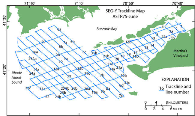
Browse_Graphic_File_Description: Browse image of seismic-line locations from cruise ASTR75-June.
Browse_Graphic_File_Type: GIF
Native_Data_Set_Environment:
Microsoft Windows XP Version 5.1 (Build 2600) Service Pack 3; ESRI ArcCatalog 9.2.6.1500
Cross_Reference:
Citation_Information:
Originator: C.J. O'Hara
Originator: R.N. Oldale
Publication_Date: 1980
Title:
Maps showing geology and shallow structure of eastern Rhode Island Sound and Vineyard Sound, Massachusetts
Geospatial_Data_Presentation_Form: map
Series_Information:
Series_Name: Miscellaneous Field Studies Map
Issue_Identification: MF-1186
Publication_Information:
Publication_Place: Reston, VA
Publisher: U.S. Geological Survey
Online_Linkage: https://pubs.usgs.gov/mf/1980/mf-1186/
Cross_Reference:
Citation_Information:
Originator: K.Y. McMullen
Originator: L.J. Poppe
Originator: N.K. Soderberg
Publication_Date: 2009
Title:
Digital Seismic-Reflection Data from Western Rhode Island Sound, 1980
Edition: 1.0
Series_Information:
Series_Name: Open-File Report
Issue_Identification: 2009-1002
Publication_Information:
Publication_Place: Reston, VA
Publisher: U.S. Geological Survey
Online_Linkage: https://pubs.usgs.gov/of/2009/1002/
Data_Quality_Information:
Attribute_Accuracy:
Attribute_Accuracy_Report: There are no attributes associated with a PNG image.
Logical_Consistency_Report: The data were edited and processed in a consistent manner.
Completeness_Report: All paper records were scanned and converted to digital images.
Lineage:
Source_Information:
Source_Citation:
Citation_Information:
Originator: USGS (assumed)
Publication_Date: unknown
Title: Information unavailable from original metadata.
Type_of_Source_Media: paper records (assumed)
Source_Time_Period_of_Content:
Time_Period_Information:
Range_of_Dates/Times:
Beginning_Date: 19750620
Ending_Date: 19750629
Source_Currentness_Reference: ground condition
Source_Citation_Abbreviation: Original seismic-reflection profiles
Source_Contribution: Information unavailable from original metadata.
Process_Step:
Process_Description:
Original seismic records of cruise ASTR75-June were obtained using a towed EG&G Uniboom system with a half-second fire rate. The signal was amplified and filtered to a 200- to 4000-Hz bandpass. The seismic data have 1- to 2-m resolution. Seismic data were printed on EPC recorders at a quarter-second sweep rate. The following systems were in operation during the survey: EG&G Uniboom Catamaran with mounted transducer, EG&G Capicitor Bank, EG&G Hydrophone Streamer, EPC Seismic Recorder (#151), Epsco Loran-C Repeater, Krohn-Hite Band Pass Filter.
Process_Date: 1980
Process_Step:
Process_Description:
Original seismic records were scanned at 300 dpi, 24-bit grayscale on an Ideal Contex Crystal TX 40 scanner using Ideal ScanOS version 2.5.4 software and saved as TIFFs, after being roughly rotated and cropped. Some seismic lines were too long to scan at once and were cut into sections, other lines were collected in sections. These sections are noted in the file names with lower-case letters after the line number. For instance, a75_625Ab_1.png signifies the cruise as R/V Asterias in 1975 (ASTR75-June), line 25A, section b, SEG-Y segment _1 and PNG format. Capitalized letters are part of the original line number, as recorded on the seismic line.
Process_Date: 2008
Process_Contact:
Contact_Information:
Contact_Person_Primary:
Contact_Person: Katherine McMullen
Contact_Organization: U.S. Geological Survey
Contact_Position: Sediment Lab Technician
Contact_Address:
Address_Type: mailing and physical address
Address: 384 Woods Hole Road
City: Woods Hole
State_or_Province: MA
Postal_Code: 02543
Country: USA
Contact_Voice_Telephone: (508) 548-8700 x2277
Contact_Facsimile_Telephone: (508) 457-2310
Contact_Electronic_Mail_Address: kmcmullen@usgs.gov
Process_Step:
Process_Description:
TIFFs were then opened in Adobe Photoshop CS2 and saved as 200 dpi grayscale TIFFs.
Process_Date: 2008
Process_Contact:
Contact_Information:
Contact_Person_Primary:
Contact_Person: Katherine McMullen
Contact_Organization: U.S. Geological Survey
Contact_Position: Sediment Lab Technician
Contact_Address:
Address_Type: mailing and physical address
Address: 384 Woods Hole Road
City: Woods Hole
State_or_Province: MA
Postal_Code: 02543
Country: USA
Contact_Voice_Telephone: (508) 548-8700 x2277
Contact_Facsimile_Telephone: (508) 457-2310
Contact_Electronic_Mail_Address: kmcmullen@usgs.gov
Process_Step:
Process_Description:
Grayscale TIFFs were further processed in Adobe Photoshop CS2 in order to aid in creating the SEG-Y files. These TIFF images were rotated so they were nearly perfectly horizontal and cropped to start and end shots with known positions and saved as PNG files. Seismic-reflection profiles that had noted changes in ship speed or places where recording stopped for belt changes were split into segments, so each file was obtained at roughly the same speed. These segments are labeled with _1 or _2 after the section, thus the file names differ slightly from the line names as used in the logbook. Since PNG images were clipped in the process of making SEG-Y files, users are encouraged to view the TIFF images available in this report (https://pubs.usgs.gov/of/2009/1003/html/eris_prof.html) in order to see field notes related to data acquisition and weather conditions, which were written directly on the paper records.
Process_Date: 2008
Process_Contact:
Contact_Information:
Contact_Person_Primary:
Contact_Person: Katherine McMullen
Contact_Organization: U.S. Geological Survey
Contact_Position: Sediment Lab Technician
Contact_Address:
Address_Type: mailing and physical address
Address: 384 Woods Hole Road
City: Woods Hole
State_or_Province: MA
Postal_Code: 02543
Country: USA
Contact_Voice_Telephone: (508) 458-8700 x2277
Contact_Facsimile_Telephone: (508) 457-2310
Contact_Electronic_Mail_Address: kmcmullen@usgs.gov
Process_Step:
Process_Description:
Edits to the metadata were made to fix any errors that MP v 2.9.36 flagged. This is necessary to enable the metadata to be successfully harvested for various data catalogs. In some cases, this meant adding text "Information unavailable" or "Information unavailable from original metadata" for those required fields that were left blank. Other minor edits were probably performed (title, publisher, publication place, etc.). Attempted to modify http to https where appropriate. An online link was added to a cross-reference. The source information was incomplete and had to be modified to meet the standard. The link to the data in the Distribution_Information section had to be fixed. The metadata date (but not the metadata creator) was edited to reflect the date of these changes. The metadata available from a harvester may supersede metadata bundled within a download file. Compare the metadata dates to determine which metadata file is most recent.
Process_Date: 20170214
Process_Contact:
Contact_Information:
Contact_Organization_Primary:
Contact_Organization: U.S. Geological Survey
Contact_Person: VeeAnn A. Cross
Contact_Position: Marine Geologist
Contact_Address:
Address_Type: Mailing and Physical
Address: 384 Woods Hole Road
City: Woods Hole
State_or_Province: MA
Postal_Code: 02543-1598
Contact_Voice_Telephone: 508-548-8700 x2251
Contact_Facsimile_Telephone: 508-457-2310
Contact_Electronic_Mail_Address: vatnipp@usgs.gov
Process_Step:
Process_Description: USGS Thesaurus keywords added to the keyword section.
Process_Date: 20180720
Process_Contact:
Contact_Information:
Contact_Organization_Primary:
Contact_Organization: U.S. Geological Survey
Contact_Person: VeeAnn A. Cross
Contact_Position: Marine Geologist
Contact_Address:
Address_Type: Mailing and Physical
Address: 384 Woods Hole Road
City: Woods Hole
State_or_Province: MA
Postal_Code: 02543-1598
Contact_Voice_Telephone: 508-548-8700 x2251
Contact_Facsimile_Telephone: 508-457-2310
Contact_Electronic_Mail_Address: vatnipp@usgs.gov
Process_Step:
Process_Description: Crossref DOI link was added as the first link in the metadata.
Process_Date: 20191118
Process_Contact:
Contact_Information:
Contact_Organization_Primary:
Contact_Organization: U.S. Geological Survey
Contact_Person: VeeAnn A. Cross
Contact_Position: Marine Geologist
Contact_Address:
Address_Type: Mailing and Physical
Address: 384 Woods Hole Road
City: Woods Hole
State_or_Province: MA
Postal_Code: 02543-1598
Contact_Voice_Telephone: 508-548-8700 x2251
Contact_Facsimile_Telephone: 508-457-2310
Contact_Electronic_Mail_Address: vatnipp@usgs.gov
Process_Step:
Process_Description:
Added keywords section with USGS persistent identifier as theme keyword.
Process_Date: 20200908
Process_Contact:
Contact_Information:
Contact_Organization_Primary:
Contact_Organization: U.S. Geological Survey
Contact_Person: VeeAnn A. Cross
Contact_Position: Marine Geologist
Contact_Address:
Address_Type: Mailing and Physical
Address: 384 Woods Hole Road
City: Woods Hole
State_or_Province: MA
Postal_Code: 02543-1598
Contact_Voice_Telephone: 508-548-8700 x2251
Contact_Facsimile_Telephone: 508-457-2310
Contact_Electronic_Mail_Address: vatnipp@usgs.gov
Spatial_Data_Organization_Information:
Direct_Spatial_Reference_Method: Raster
Distribution_Information:
Distributor:
Contact_Information:
Contact_Person_Primary:
Contact_Person: Lawrence Poppe
Contact_Organization: U.S. Geological Survey
Contact_Position: Geologist
Contact_Address:
Address_Type: mailing and physical address
Address: 384 Woods Hole Road
City: Woods Hole
State_or_Province: MA
Postal_Code: 02543
Country: USA
Contact_Voice_Telephone: (508) 548-8700 x2314
Contact_Facsimile_Telephone: (508) 457-2310
Contact_Electronic_Mail_Address: lpoppe@usgs.gov
Resource_Description: Downloadable Data: PNG images.
Distribution_Liability:
Neither the U.S. Government, the Department of the Interior, nor the USGS, nor any of their employees, contractors, or subcontractors, make any warranty, express or implied, nor assume any legal liability or responsibility for the accuracy, completeness, or usefulness of any information, apparatus, product, or process disclosed, nor represent that its use would not infringe on privately owned rights. The act of distribution shall not constitute any such warranty, and no responsibility is assumed by the USGS in the use of these data or related materials. Any use of trade, product, or firm names is for descriptive purposes only and does not imply endorsement by the U.S. Government.
Standard_Order_Process:
Digital_Form:
Digital_Transfer_Information:
Format_Name: PNG
Format_Information_Content: PNG files ranging from 6-78 Mb in size
Digital_Transfer_Option:
Online_Option:
Computer_Contact_Information: Access_Instructions: Data are downloadable via the World Wide Web (WWW)
Offline_Option:
Offline_Media: DVD-ROM
Recording_Capacity:
Recording_Density: 4.75
Recording_Density_Units: Gbytes
Recording_Format: UDF
Fees: None
Technical_Prerequisites:
The user must have graphics software capable of reading PNG files.
Available_Time_Period:
Time_Period_Information:
Single_Date/Time:
Calendar_Date: 2009
Metadata_Reference_Information:
Metadata_Date: 20211116
Metadata_Contact:
Contact_Information:
Contact_Organization_Primary:
Contact_Organization: U.S. Geological Survey
Contact_Person: Katherine McMullen
Contact_Position: Sediment Lab Technician
Contact_Address:
Address_Type: mailing and physical address
Address: 384 Woods Hole Road
City: Woods Hole
State_or_Province: MA
Postal_Code: 02543
Country: USA
Contact_Voice_Telephone: (508) 548-8700 x2277
Contact_Facsimile_Telephone: (508) 457-2310
Contact_Electronic_Mail_Address: whsc_data_contact@usgs.gov
Contact_Instructions:
The metadata contact email address is a generic address in the event the metadata contact is no longer with the USGS or the email is otherwise invalid.
Metadata_Standard_Name: FGDC Content Standards for Digital Geospatial Metadata
Metadata_Standard_Version: FGDC-STD-001-1998
Metadata_Time_Convention: local time
Metadata_Access_Constraints: None
Metadata_Use_Constraints: None

This page is <https://cmgds.marine.usgs.gov/catalog/whcmsc/open_file_report/ofr2009-1003/a75_6png_md.html>
Generated by mp version 2.9.50 on Tue Nov 16 10:06:37 2021