JPEG images of seismic reflection profiles with adjacent vibracore locations collected by the U.S. Geological Survey within Apalachicola Bay, Florida (2005-2007)

Metadata also available as - [Outline] - [Parseable text] - [XML]

Frequently anticipated questions:


What does this data set describe?

Title:
JPEG images of seismic reflection profiles with adjacent vibracore locations collected by the U.S. Geological Survey within Apalachicola Bay, Florida (2005-2007)
Abstract:
In 2007, the U.S. Geological Survey collected 24 vibracores within Apalachicola Bay, Florida. The vibracores were collected using a Rossfelder electric vibracore system during a cruise on the R/V Gilbert. Selection of the core sites was based on a geophysical survey that was conducted during 2005 and 2006 in collaboration with the National Oceanic and Atmospheric Administration's (NOAA) Coastal Services Center (CSC) and the Apalachicola Bay National Estuarine Research Reserve. This report contains the vibracore data logs and photographs, select seismic-reflection profiles (from the geophysical survey), and core-derived data including: grain size analyses, radiocarbon ages, microfossil counts, and sedimentological interpretations. The long-term goal of this study is to provide maps, data, and assistance to the Apalachicola Bay National Estuarine Research Reserve in their effort to monitor and understand the geology and ecology of Apalachicola Bay Estuary. These data will inform coastal managers charged with resource preservation.
  1. How might this data set be cited?
    U.S. Geological Survey, 2009, JPEG images of seismic reflection profiles with adjacent vibracore locations collected by the U.S. Geological Survey within Apalachicola Bay, Florida (2005-2007): Open-File Report 2009-1031, U.S. Geological Survey, Coastal and Marine Geology Program, Woods Hole Coastal and Marine Science Center, Woods Hole, MA.

    Online Links:

    This is part of the following larger work.

    Twichell, D., Pendleton, E., Poore, R., Osterman, L., and Kelso, K., 2009, Vibracore, Radiocarbon, Microfossil, and Grain-Size Data from Apalachicola Bay, Florida: Open-File Report 2009-1031, U.S. Geological Survey, Reston, VA.

    Online Links:

  2. What geographic area does the data set cover?
    West_Bounding_Coordinate: -85.074083
    East_Bounding_Coordinate: -84.831367
    North_Bounding_Coordinate: 29.727917
    South_Bounding_Coordinate: 29.605850
  3. What does it look like?
    https://pubs.usgs.gov/of/2009/1031/images/seisimage.jpg (JPEG)
    Seismic reflection profiles with vibracore locations within Apalachicola Bay, Florida
  4. Does the data set describe conditions during a particular time period?
    Beginning_Date: 29-May-2006
    Ending_Date: 26-May-2007
    Currentness_Reference:
    ground condition of two separate surveys: 20060529 to 20060627; 20070522 to 20070526
  5. What is the general form of this data set?
    Geospatial_Data_Presentation_Form: raster digital data
  6. How does the data set represent geographic features?
    1. How are geographic features stored in the data set?
      This is a Raster data set. It contains the following raster data types:
      • Dimensions, type Pixel
    2. What coordinate system is used to represent geographic features?
  7. How does the data set describe geographic features?

Who produced the data set?

  1. Who are the originators of the data set? (may include formal authors, digital compilers, and editors)
    • U.S. Geological Survey
  2. Who also contributed to the data set?
  3. To whom should users address questions about the data?
    David C. Twichell
    U.S. Geological Survey
    Oceanographer
    384 Woods Hole Rd.
    Woods Hole, MA

    (508) 548-8700x2266 (voice)
    (508) 457-2310 (FAX)
    dtwichell@usgs.gov

Why was the data set created?

These data are JPEG files of seismic reflection profiles (collected in 2006; published by Twichell and others, 2007) that are adjacent to vibracores collected by the U.S. Geological Survey during a 2007 cruise within Apalachicola Bay, Florida. These data are included to give the vibracores greater stratigraphic context. JPEG format is universal and yields an easily browseable pictorial view of the seismic profiles. Each profile image is hotlinked to its corresponding trackline navigation contained within a polyline shapefile (Seismic_Cores_INT.shp). These images also have representations of vibracore locations, which show the calculated core penetration depth on the profile. Core depth was determined by assuming a constant speed of sound in sediment and seawater of 1500 m/sec.

How was the data set created?

  1. From what previous works were the data drawn?
    USGS (source 1 of 1)
    Twichell, D.C., Andrews, B.D., Edmiston, H.L., and Stevenson, W.R., 2007, Geophysical Mapping of Oyster Habitats in a Shallow Estuary; Apalachicola Bay, Florida: Open-File Report 2006-1381, U.S. Geological Survey, Reston, VA.

    Online Links:

    Type_of_Source_Media: disc
    Source_Contribution:
    In order to give the vibracore data greater stratigraphic context, seismic images and trackline data from the geophysical survey completed 2006 are included in this report (Twichell and others, 2007). Twenty-four vibracores were collected within Apalachicola Bay, Florida during May 2007. Vibracore sites were selected based on the identification of target areas. These target areas were chosen from the analysis of geophysical data collected during 2005 and 2006 in collaboration with the National Oceanic and Atmospheric Administration's (NOAA) Coastal Services Center (CSC) and the Apalachicola Bay National Estuarine Research Reserve (Twichell and others, 2007). The vibracores were collected using a Rossfelder electric vibracore system. The cores were collected in a 7.62 cm (3 in) diameter by 6.10 m (20 ft) long aluminum tube with a copper core catcher riveted to the bottom. The vibracoring rig was mounted, deployed, and recovered on the port side of the R/V Gilbert. The ship was anchored from the bow and stern to maintain ship position as a hydraulic crane deployed and recovered the coring rig. Following recovery, the bottom of the core was capped with a plastic cap, water was drained from the top of the core barrel by drilling a hole in the aluminum tube immediately above the sediment/water interface, and the pipe was cut at the sediment/water interface. Each core was cut into one-meter sections (measuring down from the sediment/water interface) on the boat deck, the ends were capped, each section labeled, and stored on deck for transport. Core sections for all 24 vibracores were transported to the U.S. Geological Survey Florida Integrated Science Center (FISC) where the 1-meter core sections were split in half (lengthwise) in the FISC core laboratory. One half of each core section was preserved and archived in a clear plastic sleeve with the ends taped shut to minimize moisture loss. The other half, the working half, of the core was used for visual descriptions, photographs, and eventually sub-sampling for radiocarbon, microfossil, and grain-size analysis.
  2. How were the data generated, processed, and modified?
    Date: 2008 (process 1 of 6)
    The original seismic trackline shapefile was edited to include only the tracklines that were adjacent to vibracore sites. The seismic-reflection profiles (in JPEG format) corresponding to the adjacent tracklines were also selected. Seismic-reflection JPEG images were imported into Adobe Illustrator (version CS2) and vibracore locations and lengths were added to the profile. Depths on the seismic profiles are shown in two-way travel time, and core lengths were converted to travel time assuming a speed of sound in water and sediment of 1500 m/sec; or 0.75 meters/ two-way travel time in milliseconds. Person who carried out this activity:
    David C. Twichell
    U.S. Geological Survey
    Oceanographer
    384 Woods Hole Rd.
    Woods Hole, MA

    (508) 548-8700x2266 (voice)
    (508) 457-2310 (FAX)
    dtwichell@usgs.gov
    Date: 2008 (process 2 of 6)
    The seismic-reflection profiles, edited to include core locations and lengths, were exported from Adobe Illustrator (CS2) as JPEG images. Person who carried out this activity:
    David C. Twichell
    U.S. Geological Survey
    Oceanographer
    384 Woods Hole Rd.
    Woods Hole, MA

    (508) 548-8700x2266 (voice)
    (508) 457-2310 (FAX)
    dtwichell@usgs.gov
    Date: 16-Feb-2017 (process 3 of 6)
    Edits to the metadata were made to fix any errors that MP v 2.9.36 flagged. This is necessary to enable the metadata to be successfully harvested for various data catalogs. In some cases, this meant adding text "Information unavailable" or "Information unavailable from original metadata" for those required fields that were left blank. Other minor edits were probably performed (title, publisher, publication place, etc.). Attempted to modify http to https where appropriate. Added a link in the identification section to the catalog html page. Fixed the date format in the time period of content and the source information. The distribution format name was modified in an attempt to be more consistent with other metadata files of the same data format. The metadata date (but not the metadata creator) was edited to reflect the date of these changes. The metadata available from a harvester may supersede metadata bundled within a download file. Compare the metadata dates to determine which metadata file is most recent. Person who carried out this activity:
    U.S. Geological Survey
    Attn: VeeAnn A. Cross
    Marine Geologist
    384 Woods Hole Road
    Woods Hole, MA

    508-548-8700 x2251 (voice)
    508-457-2310 (FAX)
    vatnipp@usgs.gov
    Date: 20-Jul-2018 (process 4 of 6)
    USGS Thesaurus keywords added to the keyword section. Person who carried out this activity:
    U.S. Geological Survey
    Attn: VeeAnn A. Cross
    Marine Geologist
    384 Woods Hole Road
    Woods Hole, MA

    508-548-8700 x2251 (voice)
    508-457-2310 (FAX)
    vatnipp@usgs.gov
    Date: 18-Nov-2019 (process 5 of 6)
    Crossref DOI link was added as the first link in the metadata. Person who carried out this activity:
    U.S. Geological Survey
    Attn: VeeAnn A. Cross
    Marine Geologist
    384 Woods Hole Road
    Woods Hole, MA

    508-548-8700 x2251 (voice)
    508-457-2310 (FAX)
    vatnipp@usgs.gov
    Date: 08-Sep-2020 (process 6 of 6)
    Added keywords section with USGS persistent identifier as theme keyword. Person who carried out this activity:
    U.S. Geological Survey
    Attn: VeeAnn A. Cross
    Marine Geologist
    384 Woods Hole Road
    Woods Hole, MA

    508-548-8700 x2251 (voice)
    508-457-2310 (FAX)
    vatnipp@usgs.gov
  3. What similar or related data should the user be aware of?
    Twichell, D., Andrews, B., Edmiston, H., and Stevenson, W., 2007, Geophysical Mapping of Oyster Habitats in a Shallow Estuary; Apalachicola Bay, Florida: U.S. Geological Survey Open-File Report 2006-1381, U.S. Geological Survey, Reston, VA.

    Online Links:


How reliable are the data; what problems remain in the data set?

  1. How well have the observations been checked?
    There are no attributes associated with these JPEG images
  2. How accurate are the geographic locations?
    Survey lines from the SB-0512i that was towed behind the R/V Rafael are thought to have an accuracy of +/-20 meters, primarily because the towfish layback was not acounted for. Survey lines collected from the ASV (Autonomous Surface Vehicle) are expected to have higher accuracy due to the close mounted real-time kinematic GPS receiver. These data are likely accurate to +/- 5 meters.
  3. How accurate are the heights or depths?
  4. Where are the gaps in the data? What is missing?
    Of the 921 seismic-reflection lines collected in 2005 and 2006 (Twichell and others, 2007), only 19 were selected for inclusion in this report. These 19 seismic images represent the seismic-reflection profiles that were adjacent to the 24 vibracores collected in 2007. All vibracores were collected from the R/V Gilbert using a Rossfelder vibracore. One vibracore was collected at each of the 23 predetermined locations, with the exception of site 18. Two cores were collected here because the first core (App07-18A) was recovered without a core catcher on the end, and several centimeters of the sample were lost. A second core was taken (App07-18B) at site 18, and both cores were processed and preserved. Core 18A is not shown on the seismic-reflection profile, because core 18B is a more complete sample from the same site.
  5. How consistent are the relationships among the observations, including topology?
    Seismic-reflection profiles that were adjacent to 24 vibracores collected in 2007 in Apalachicola Bay, FL were selected from a published geophysical dataset (Twichell and others, 2007). Only the profiles within the near vicinity (50 meters) of a vibracore were chosen for inclusion in this report.

How can someone get a copy of the data set?

Are there legal restrictions on access or use of the data?
Access_Constraints None
Use_Constraints The Public domain data from the U.S. Government are freely redistributable with proper metadata and source attribution. Please recognize the U.S. Geological Survey as the originator of the dataset.
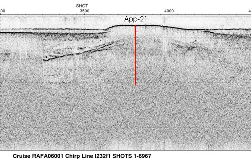
  1. Who distributes the data set? (Distributor 1 of 1)
    David C. Twichell
    U.S. Geological Survey
    Oceanographer
    384 Woods Hole Rd.
    Woods Hole, MA

    (508) 548-8700x2266 (voice)
    (508) 457-2310 (FAX)
    dtwichell@usgs.gov
  2. What's the catalog number I need to order this data set? Downloadable Data
  3. What legal disclaimers am I supposed to read?
    Neither the U.S. Government, the Department of the Interior, nor the USGS, nor any of their employees, contractors, or subcontractors, make any warranty, express or implied, nor assume any legal liability or responsibility for the accuracy, completeness, or usefulness of any information, apparatus, product, or process disclosed, nor represent that its use would not infringe on privately owned rights. The act of distribution shall not constitute any such warranty, and no responsibility is assumed by the USGS in the use of these data or related materials. Any use of trade, product, or firm names is for descriptive purposes only and does not imply endorsement by the U.S. Government.
  4. How can I download or order the data?
    • Availability in digital form:
      Data format: This WinZip (version 9.0) file contains 19 JPEG images of processed seismic-reflection profiles with vibracore locations from within Apalachicola Bay, Florida and the associated metadata. in format JPEG (version Information unavailable from original metadata.) Size: 71
      Network links: https://pubs.usgs.gov/of/2009/1031/data_catalog/Seismic_Tracks_Profiles/seismic_core_images.zip
      Media you can order: DVD-ROM (Density 4.75 Gbytes) (format UDF)
    • Cost to order the data: None

  5. What hardware or software do I need in order to use the data set?
    These data can viewed with any JPEG viewing software.

Who wrote the metadata?

Dates:
Last modified: 18-Mar-2024
Metadata author:
Elizabeth A. Pendleton
U.S. Geological Survey
Geologist
384 Woods Hole Road
Woods Hole, MA
USA

508-548-8700 x2259 (voice)
(508)-457-2310 (FAX)
whsc_data_contact@usgs.gov
Contact_Instructions:
The metadata contact email address is a generic address in the event the person is no longer with USGS. (updated on 20240318)
Metadata standard:
FGDC Content Standards for Digital Geospatial Metadata (FGDC-STD-001-1998)

This page is <https://cmgds.marine.usgs.gov/catalog/whcmsc/open_file_report/ofr2009-1031/Seismic_image_metadata_holdermeta.faq.html>
Generated by mp version 2.9.51 on Mon Mar 25 16:05:27 2024