JPEG formatted images of EdgeTech SB-512i and SB-424 chirp seismic-reflection profiles collected by the U.S. Geological Survey offshore of Massachusetts between Duxbury and Hull (DH_SeismicProfiles)

Metadata also available as - [Outline] - [Parseable text] - [XML]

Frequently anticipated questions:


What does this data set describe?

Title:
JPEG formatted images of EdgeTech SB-512i and SB-424 chirp seismic-reflection profiles collected by the U.S. Geological Survey offshore of Massachusetts between Duxbury and Hull (DH_SeismicProfiles)
Abstract:
These data were collected under a cooperative agreement with the Massachusetts Office of Coastal Zone Management (CZM) and the U.S. Geological Survey (USGS), Coastal and Marine Geology Program, Woods Hole Science Center (WHSC). Initiated in 2003, the primary objective of this program is to develop regional geologic framework information for the management of coastal and marine resources. Accurate data and maps of sea-floor geology are important first steps toward protecting fish habitat, delineating marine resources, and assessing environmental changes due to natural or human impacts. The project is focused on the inshore waters (5-30 m deep) of Massachusetts between the New Hampshire border and Cape Cod Bay. Data collected for the mapping cooperative have been released in a series of USGS Open-File Reports (https://woodshole.er.usgs.gov/project-pages/coastal_mass/). This spatial dataset is from the study area located between Duxbury and Hull Massachusetts, and consists of high-resolution geophysics (bathymetry, backscatter intensity, and seismic reflection) and ground validation (sediment samples, video tracklines and bottom photographs). The data were collected during four separate surveys conducted between 2003 and 2007 (NOAA survey H10993 in 2003, USGS-WHSC survey 06012 in 2006, and USGS-WHSC surveys 07001 and 07003 in 2007) and cover more than 200 square kilometers of the inner continental shelf.
  1. How might this data set be cited?
    U.S. Geological Survey, 2010, JPEG formatted images of EdgeTech SB-512i and SB-424 chirp seismic-reflection profiles collected by the U.S. Geological Survey offshore of Massachusetts between Duxbury and Hull (DH_SeismicProfiles): Open-File Report 2009-1072, U.S. Geological Survey, Coastal and Marine Geology Program, Woods Hole Coastal and Marine Science Center, Woods Hole, MA.

    Online Links:

    This is part of the following larger work.

    Barnhardt, Walter A., Ackerman, Seth D., Andrews, Brian D., and Baldwin, Wayne E., 2010, Geophysical and Sampling Data from the Inner Continental Shelf: Duxbury to Hull, Massachusetts.: Open-File Report 2009-1072, U.S. Geological Survey, Reston, VA.

    Online Links:

  2. What geographic area does the data set cover?
    West_Bounding_Coordinate: -70.828283
    East_Bounding_Coordinate: -70.595687
    North_Bounding_Coordinate: 42.339977
    South_Bounding_Coordinate: 42.080213
  3. What does it look like?
    https://pubs.usgs.gov/of/2009/1072/GIS/browse_jpg/big/DH_SeismicReflectionProfiles.jpg (JPEG)
    JPEG image of a chirp seismic-reflection profile
  4. Does the data set describe conditions during a particular time period?
    Beginning_Date: 04-Aug-2006
    Ending_Date: 02-May-2007
    Currentness_Reference:
    ground condition of two separate surveys. The dates for the surveys were 20060804 to 20060820 and 20070422 to 20070502.
  5. What is the general form of this data set?
    Geospatial_Data_Presentation_Form: raster digital data
  6. How does the data set represent geographic features?
    1. How are geographic features stored in the data set?
      This is a Raster data set. It contains the following raster data types:
      • Dimensions, type pixel
    2. What coordinate system is used to represent geographic features?
  7. How does the data set describe geographic features?

Who produced the data set?

  1. Who are the originators of the data set? (may include formal authors, digital compilers, and editors)
    • U.S. Geological Survey
  2. Who also contributed to the data set?
  3. To whom should users address questions about the data?
    Wayne Baldwin
    U.S. Geological Survey
    Geologist
    384 Woods Hole Rd.
    Woods Hole, MA

    508-548-8700 x2226 (voice)
    508-457-2310 (FAX)
    wbaldwin@usgs.gov

Why was the data set created?

JPEG images of each seismic profile were generated in order to incorporate images of the seismic profiles into Geographic Information System (GIS) projects and data archives utilizing HTML. The JPEG images represent approximately 1920 km of EdgeTech SB-512i SB-424 chirp seismic-reflection profiles collected within the Duxbury to Hull survey area. Each profile image is hotlinked to its corresponding trackline navigation contained within the ESRI polyline shapefile 'DH_SeismicTracklines.shp'. Even 500 shot index markers along the top of the JPEG images correlate to the positions of 500 shot intervals within the ESRI point shapefile 'DH_SeismicShot_500.shp'.

How was the data set created?

  1. From what previous works were the data drawn?
    Information unavailable from original metadata. (source 1 of 1)
    (assumed), USGS, unknown, Information unavailable from original metadata..

    Type_of_Source_Media: Information unavailable from original metadata.
    Source_Contribution:
    Seismic-reflection data acquisition 06012: Chirp seismic data were collected using an EdgeTech Geo-Star FSSB sub-bottom profiling system and an SB-0512i towfish (0.5-12 kHz), which was mounted on a catamaran and towed astern of the R/V Megan T. Miller of Port Jefferson, NY. EdgeTech J-Star seismic acquisition software was used to control the Geo-Star topside unit and digitally log trace data in the EdgeTech JSF format. Data were acquired using a 0.25-s shot rate, a 9-ms pulse length, and a 0.5 to 6 kHz frequency sweep. Recorded trace lengths were approximately 266 ms. Tracklines were spaced between 100 and 200 m apart in the shore parallel direction and between 1 and 3 km apart in the shore perpendicular direction.
    Seismic-reflection data acquisition 07001: Chirp seismic data were collected using an EdgeTech Geo-Star FSSB sub-bottom profiling system and an SB-424 towfish (4-24 kHz), which was mounted on a rigid pole on the starboard side of the R/V Rafael of Woods Hole, MA. EdgeTech J-Star and Triton Imaging Inc. SB-Logger seismic acquisition software was used to control the Geo-Star topside unit and digitally log trace data in EdgeTech JSF and SEG-Y Rev. 1 formats, respectively. Data were acquired using a 0.25-s shot rate, a 10-ms pulse length, and a 4 to 16 kHz frequency sweep. Recorded trace lengths were approximately 250 ms. Tracklines were spaced 100 m apart in the shore parallel direction and between 200 m and 2 km apart in the shore perpendicular direction.
  2. How were the data generated, processed, and modified?
    Date: Oct-2008 (process 1 of 7)
    A script was run that used SIOSEIS (version 2007.8) to predict and remove sea surface heave, and mute water column portions of SB-512i and SB-424 seismic traces by: 1)automatically picking the sea floor by identifying peak amplitudes within a vertical window; 2)smoothing sea floor picks using an along track filter approximating the period of sea surface heave (the filter window was set to use 46 traces); 3)creating a series of difference values between the raw and smoothed seafloor picks for each trace; 4)shifting traces up or down according to the difference values; and 5) muting each trace between time zero and the time of the smoothed sea floor pick, thus removing noise within the water column. Changes to the traces within each profile were saved to new "heave corrected" SEG-Y files, which were used for creation of JPEG browse images and digital interpretation. Person who carried out this activity:
    Wayne Baldwin
    U.S. Geological Survey
    Geologist
    384 Woods Hole Rd.
    Woods Hole, MA

    508-548-8700 x2226 (voice)
    508-457-2310 (FAX)
    wbaldwin@usgs.gov
    Date: Oct-2008 (process 2 of 7)
    An AWK (no version) script was run that used Seismic Unix (version 4.1) to read the SEG-Y files and plot the data as 8-bit gray scale Postscript files using the Seismic Unix 'psimage' algorithm. All images were created with a horizontal scale of 200 traces per inch. The profiles contain 80 milliseconds of Two-Way Travel Time within an 8-inch vertical window, yielding 10 milliseconds per inch. Postscript images were converted to JPEG format using ImageMagick (version 5.5.6). Person who carried out this activity:
    Wayne Baldwin
    U.S. Geological Survey
    Geologist
    384 Woods Hole Rd.
    Woods Hole, MA

    508-548-8700 x2226 (voice)
    508-457-2310 (FAX)
    wbaldwin@usgs.gov
    Date: Aug-2009 (process 3 of 7)
    JPEG images were resized to enable quicker and easier downloading for online users of the Open-File Report using IrfanView (v4.23). The original JPEG images (found in the folders by survey ID in GIS\hyperlink_images\seisimage\) were resized to 75 percent the original pixel size and downsampled with a save quality of 80 percent. These downsampled and resized images are included in the zipped file DH_SeismicProfiles.zip (https://pubs.usgs.gov/of/2009/1072/html/appendix1.html). Person who carried out this activity:
    Seth Ackerman
    U.S. Geological Survey
    Geologist
    384 Woods Hole Rd.
    Woods Hole, MA
    USA

    508-548-8700 x2315 (voice)
    508-457-2310 (FAX)
    sackerman@usgs.gov
    Data sources used in this process:
    • Full sized JPEG images
    Data sources produced in this process:
    • Downsampled and resized JPEG images (same filenames)
    Date: 02-Feb-2017 (process 4 of 7)
    Edits to the metadata were made to fix any errors that MP v 2.9.36 flagged. This is necessary to enable the metadata to be successfully harvested for various data catalogs. In some cases, this meant adding text "Information unavailable" or "Information unavailable from original metadata" for those required fields that were left blank. Other minor edits were probably performed (title, publisher, publication place, etc.). Attempted to modify http to https where appropriate. Fixed a link to the project page in the abstract. Fixed an online link in a cross-reference. The source information was incomplete and had to be modified to meet the standard. The distribution format name was modified in an attempt to be more consistent with other metadata files of the same data format. The metadata date (but not the metadata creator) was edited to reflect the date of these changes. The metadata available from a harvester may supersede metadata bundled within a download file. Compare the metadata dates to determine which metadata file is most recent. Person who carried out this activity:
    U.S. Geological Survey
    Attn: VeeAnn A. Cross
    Marine Geologist
    384 Woods Hole Road
    Woods Hole, MA

    508-548-8700 x2251 (voice)
    508-457-2310 (FAX)
    vatnipp@usgs.gov
    Date: 20-Jul-2018 (process 5 of 7)
    USGS Thesaurus keywords added to the keyword section. Person who carried out this activity:
    U.S. Geological Survey
    Attn: VeeAnn A. Cross
    Marine Geologist
    384 Woods Hole Road
    Woods Hole, MA

    508-548-8700 x2251 (voice)
    508-457-2310 (FAX)
    vatnipp@usgs.gov
    Date: 18-Nov-2019 (process 6 of 7)
    Crossref DOI link was added as the first link in the metadata. Person who carried out this activity:
    U.S. Geological Survey
    Attn: VeeAnn A. Cross
    Marine Geologist
    384 Woods Hole Road
    Woods Hole, MA

    508-548-8700 x2251 (voice)
    508-457-2310 (FAX)
    vatnipp@usgs.gov
    Date: 08-Sep-2020 (process 7 of 7)
    Added keywords section with USGS persistent identifier as theme keyword. Person who carried out this activity:
    U.S. Geological Survey
    Attn: VeeAnn A. Cross
    Marine Geologist
    384 Woods Hole Road
    Woods Hole, MA

    508-548-8700 x2251 (voice)
    508-457-2310 (FAX)
    vatnipp@usgs.gov
  3. What similar or related data should the user be aware of?
    Stockwell, John, 2008, CWP/SU: Seismic Uni*x: Center for Wave Phenomena - Colorado School of Mines, Golden, CO.

    Online Links:

    Henkart, Paul, 2007, SIOSEIS: Scripps Institution of Oceanography, University of California - San Diego, LaJolla, CA.

    Online Links:

    Michael W. Norris and Alan K. Faichney, 2002, SEGY Rev.1 Data Exchange Format1: Society of Exploration Geophysicists, Tulsa, OK.

    Online Links:

    Barnhardt, Walter A., Andrews, Brian D., and Butman, Bradford, 2006, High-Resolution Mapping of the Inner Continental Shelf: Nahant to Gloucester, Massachusetts: Open-File Report 2005-1293, U.S. Geological Survey, Reston, VA.

    Online Links:

    Ackerman, Seth D., Butman, Bradford, Barnhardt, Walter A., Danforth, William W., and Crocker, James M., 2006, High-Resolution Geologic Mapping of the Inner Continental Shelf: Boston Harbor and Approaches, Massachusetts: Open-File Report 2006-1008, U.S. Geological Survey, Reston, VA.

    Online Links:

    Barnhardt, Walter A., Andrews, Brian D., Ackerman, Seth D., Baldwin, Wayne E., and Hein, Christopher J., 2009, High-Resolution Geological Mapping of the Inner Continental Shelf: Cape Ann to Salisbury Beach, Massachusetts: Open-File Report 2007-1373, U.S. Geological Survey, Reston, VA.

    Online Links:


How reliable are the data; what problems remain in the data set?

  1. How well have the observations been checked?
  2. How accurate are the geographic locations?
    Field activity 06012: The SB-0512i was mounted on a catamaran sled and towed at the sea surface approximately 30 - 40 m astern of the R/V Megan T. Miller. Position data were provided by a Global Positioning System (GPS) navigation receiver mounted on the catamaran, and data were transmitted to the acquisition computer on the vessel via a 2.4 GHz radio link. During some portions of the survey, technical difficulties caused the GPS system mounted on the catamaran to malfunction. In these instances Real Time Kinematic (RTK) GPS navigation was obtained from a receiver mounted above the interferometric sonar head (This applies to files l25f2000 through l84f2000 acquired during Julian days 218 through 222). Layback positions, which account for the linear distance between the shipboard RTK-GPS receiver and the towed catamaran vehicle, were calculated trigonometrically during post-processing (see processing step 3). While the vehicle mounted GPS antenna was operational, positional accuracy is assumed to be ± 10 m. While the vehicle mounted GPS was not operational, positional accuracy is assumed to be ± 20 m; increased uncertainty arises because layback calculations do not account for fish motion behind the vessel, which is caused by sea state and vessel speed induced changes in the angle and scope of the tow cable. Field activity 07001: The SB-424 was mounted on a rigid pole, approximately 1 m below the sea surface on the starboard side of the R/V Rafael. Position data were provided by a RTK-GPS navigation receiver mounted directly above the interferometric sonar head. While horizontal offsets between the SB-424 transducer and the RTK-GPS navigation receiver were not corrected in the sonar setup, this distance was less than 3 m, and the resulting positional accuracy is assumed to be ± 10 m.
  3. How accurate are the heights or depths?
  4. Where are the gaps in the data? What is missing?
    Only the subsets of seismic-reflection data collected during field activities 06012 and 07001 that are within the study area between Duxbury and Hull have been included in this raster dataset. Approximately 945 km of additional seismic-reflection profiles collected south of Brant Rock, Massachusetts during these field activities will be published in a subsequent data release focused on Cape Cod Bay.
  5. How consistent are the relationships among the observations, including topology?
    Processed seismic data were converted to JPEG format for ease of seismic trace display. Quality control was conducted during processing.

How can someone get a copy of the data set?

Are there legal restrictions on access or use of the data?
Access_Constraints none
Use_Constraints Public domain data from the U.S. Government are freely redistributable with proper metadata and source attribution. Please recognize the U.S. Geological Survey as the source of this information.
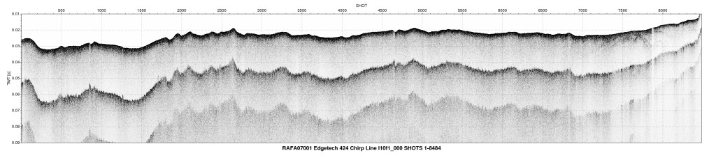
  1. Who distributes the data set? (Distributor 1 of 1)
    Wayne Baldwin
    U.S. Geological Survey, Woods Hole Science Center
    Geologist
    384 Woods Hole Rd.
    Woods Hole, MA
    USA

    508-548-8700 x2226 (voice)
    wbaldwin@usgs.gov
  2. What's the catalog number I need to order this data set? Downloadable Data
  3. What legal disclaimers am I supposed to read?
    Neither the U.S. Government, the Department of the Interior, nor the USGS, nor any of their employees, contractors, or subcontractors, make any warranty, express or implied, nor assume any legal liability or responsibility for the accuracy, completeness, or usefulness of any information, apparatus, product, or process disclosed, nor represent that its use would not infringe on privately owned rights. The act of distribution shall not constitute any such warranty, and no responsibility is assumed by the USGS in the use of these data or related materials. Any use of trade, product, or firm names is for descriptive purposes only and does not imply endorsement by the U.S. Government.
  4. How can I download or order the data?
    • Availability in digital form:
      Data format: Zip compressed JPEG images of processed EdgeTech SB-512i and SB-424 seismic-reflection profiles and associated metadata. in format JPEG (version unknown) Joint Photographic Experts Group Size: 71
      Network links: https://pubs.usgs.gov/of/2009/1072/GIS/hyperlink_images/DH_SeismicProfiles.zip
      Media you can order: DVD-ROM (Density 4.75 Gbytes) (format UDF)
    • Cost to order the data: none

  5. Is there some other way to get the data?
    Digital copies of these chirp seismic data may also be obtained in the SEG-Y Rev. 1 standard format upon request. The data would be packaged on DVD, and contain the chirp-processed, envelope traces.
  6. What hardware or software do I need in order to use the data set?
    These data can be viewed with any JPEG image viewing software.

Who wrote the metadata?

Dates:
Last modified: 18-Mar-2024
Metadata author:
Wayne Baldwin
U.S. Geological Survey
Geologist
384 Woods Hole Rd.
Woods Hole, MA
USA

508-548-8700 x2226 (voice)
508-457-2310 (FAX)
whsc_data_contact@usgs.gov
Contact_Instructions:
The metadata contact email address is a generic address in the event the person is no longer with USGS. (updated on 20240318)
Metadata standard:
FGDC Content Standards for Digital Geospatial Metadata (FGDC-STD-001-1998)

This page is <https://cmgds.marine.usgs.gov/catalog/whcmsc/open_file_report/ofr2009-1072/DH_SeismicProfiles_metadata.faq.html>
Generated by mp version 2.9.51 on Mon Mar 25 16:05:28 2024