Citation:
Citation_Information:
Originator: VeeAnn A. Cross
Publication_Date: 2010
Title:
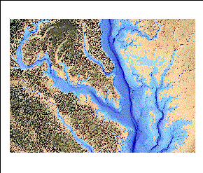
Color-hillshade relief GeoTIFF image of the Potomac River/Chesapeake Bay Area (CLRHSHD_POTO.TIF, UTM, Zone 18, NAD83)
Geospatial_Data_Presentation_Form: raster digital data
Series_Information:
Series_Name: Open-File Report
Issue_Identification: 2009-1151
Publication_Information:
Publication_Place: Woods Hole Coastal and Marine Science Center, Woods Hole, MA
Publisher: U.S. Geological Survey, Coastal and Marine Geology Program
Online_Linkage: https://doi.org/10.3133/ofr20091151
Online_Linkage: http://pubs.usgs.gov/of/2009/1151/data/basemap/clrhshd_poto.zip
Online_Linkage: http://pubs.usgs.gov/of/2009/1151/html/catalog.html
Larger_Work_Citation:
Citation_Information:
Originator: VeeAnn A. Cross
Originator: David S. Foster
Originator: John F. Bratton
Publication_Date: 2010
Title:
Continuous Resistivity Profiling and Seismic-Reflection Data Collected in 2006 from the Potomac River Estuary, Virginia and Maryland
Series_Information:
Series_Name: Open-File Report
Issue_Identification: 2009-1151
Publication_Information:
Publication_Place: Reston, VA
Publisher: U.S. Geological Survey
Online_Linkage: http://pubs.usgs.gov/of/2009/1151/
Description:
Abstract:
In order to test hypotheses about groundwater flow under and into Chesapeake Bay, geophysical surveys were conducted by U.S. Geological Survey (USGS) scientists on Chesapeake Bay and the Potomac River Estuary in September 2006. Chesapeake Bay resource managers are concerned about nutrients that are entering the estuary via submarine groundwater discharge, which are contributing to eutrophication. The USGS has performed many related studies in recent years to provide managers with information necessary to make informed decisions about this issue. The research carried out as part of the study described here was designed to help refine nutrient budgets for Chesapeake Bay by characterizing submarine groundwater flow and discharge of groundwater beneath part of the mainstem and a major tributary, the Potomac River Estuary.
Purpose:
The purpose of this dataset is to provide the color-hillshade relief image of the Potomac area in GeoTIFF format (UTM zone 18, NAD83) that can be viewed by a variety of software programs.
Time_Period_of_Content:
Time_Period_Information:
Multiple_Dates/Times:
Single_Date/Time:
Calendar_Date: 1998
Single_Date/Time:
Calendar_Date: 1999
Currentness_Reference:
Publication data of the original datasets used to general the elevation grid from which this was derived.
Status:
Progress: Complete
Maintenance_and_Update_Frequency: None planned
Spatial_Domain:
Bounding_Coordinates:
West_Bounding_Coordinate: -77.387222
East_Bounding_Coordinate: -75.604370
North_Bounding_Coordinate: 38.729651
South_Bounding_Coordinate: 37.706801
Keywords:
Theme:
Theme_Keyword_Thesaurus: USGS Metadata Identifier
Theme_Keyword: USGS:cb81acf6-8b27-4193-9f81-e790dae115ad
Theme:
Theme_Keyword_Thesaurus: None
Theme_Keyword: U.S. Geological Survey
Theme_Keyword: USGS
Theme_Keyword: Coastal and Marine Geology Program
Theme_Keyword: CMGP
Theme_Keyword: Woods Hole Coastal and Marine Science Center
Theme_Keyword: WHCMSC
Theme_Keyword: Info Bank ID K-1-06-CH
Theme_Keyword: bathymetry
Theme_Keyword: NOAA's Ocean Service, Special Projects
Theme_Keyword: hydrographic survey
Theme_Keyword: estuary
Theme_Keyword: estuarine bathymetry
Theme_Keyword: elevation
Theme_Keyword: digital elevation model
Theme_Keyword: DEM
Theme_Keyword: raster
Theme_Keyword: National Elevation Dataset
Theme_Keyword: NED
Theme_Keyword: color-hillshade relief
Theme_Keyword: GeoTIFF
Theme:
Theme_Keyword_Thesaurus: ISO 19115 Topic Category
Theme_Keyword: inlandWaters
Theme_Keyword: oceans
Theme_Keyword: imageryBaseMapsEarthCover
Theme:
Theme_Keyword_Thesaurus: USGS Thesaurus
Theme_Keyword: sea-floor characteristics
Theme_Keyword: marine geophysics
Theme_Keyword: computational methods
Theme_Keyword: geospatial datasets
Theme_Keyword: topography
Place:
Place_Keyword_Thesaurus: None
Place_Keyword: North America
Place_Keyword: North Atlantic
Place_Keyword: United States
Place_Keyword: Virginia
Place_Keyword: Potomac River Estuary
Place_Keyword: Chesapeake Bay
Place_Keyword: Maryland
Access_Constraints: None.
Use_Constraints:
The public domain data from the U.S. Government are freely redistributable with proper metadata and source attribution. Please recognize the U.S. Geological Survey and the National Oceanic and Atmospheric Administration (NOAA) National Ocean Service (NOS) as the originators of the individual datasets. These data are not to be used for navigation.
Point_of_Contact:
Contact_Information:
Contact_Person_Primary:
Contact_Person: VeeAnn A. Cross
Contact_Organization: U.S. Geological Survey
Contact_Position: Marine Geologist
Contact_Address:
Address_Type: mailing and physical address
Address: Woods Hole Coastal and Marine Science Center
Address: 384 Woods Hole Rd.
City: Woods Hole
State_or_Province: MA
Postal_Code: 02543-1598
Contact_Voice_Telephone: (508) 548-8700 x2251
Contact_Facsimile_Telephone: (508) 457-2310
Contact_Electronic_Mail_Address: [email protected]
Browse_Graphic:
Native_Data_Set_Environment:
Microsoft Windows XP Version 5.1 (Build 2600) Service Pack 3; ESRI ArcCatalog 9.2.6.1500
Cross_Reference:
Citation_Information:
Originator:
Department of Commerce (DOC), National Oceanic and Atmospheric Administration (NOAA), National Ocean Service (NOS), Special Projects (SP)
Publication_Date: 1998
Title:
Chesapeake Bay, VA/MD (M130) Bathymetric Digital Elevation Model (30 meter resolution) Derived From Source Hydrographic Survey Soundings Collected by NOAA
Geospatial_Data_Presentation_Form: raster digital data
Publication_Information:
Publication_Place: Silver Spring, MD
Publisher: NOAA's Ocean Service, Special Projects (SP)
Online_Linkage: http://estuarinebathymetry.noaa.gov/
Cross_Reference:
Citation_Information:
Originator: U.S. Geological Survey (USGS), EROS Data Center
Publication_Date: 1999
Title: National Elevation Dataset
Publication_Information:
Publication_Place: Sioux Falls, SD
Publisher: U.S. Geological Survey
Online_Linkage: http://ned.usgs.gov/
Online_Linkage: http://seamless.usgs.gov/