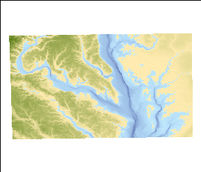
This dataset represent complete elevation information for the area of interest.
Horizontal_Positional_Accuracy:
Horizontal_Positional_Accuracy_Report:
This grid is a combination of two dataset that provide the best-available data for the land elevations and the bathymetry of Chesapeake Bay. The 7.5-minute elevation data for the conterminous United States are the primary initial source data for the land elevation and were acquired from the National Elevation Dataset (NED). The bathymetry dataset was acquired from the NOAA estuarine bathymetry website. This dataset was derived from two hundred ninety-seven surveys dating from 1850 to 1993. The NED website does not specify any value for horizontal accuracy. According to the metadata accompanying the bathymetry dataset, the horizontal accuracy is expressed as an estimated root mean square error (RMSE). The estimate of the RMSE is based upon horizontal accuracy tests of the source soundings used to generate the DEM. As a first approximation the locational accuracy of the source soundings are 0.0015 m at source "Smooth Sheet" scale (120 m @ 1:80,000 to 15 m @ 1:10,000). Smooth Sheets are maps generated as a principle product of each (historic) hydrographic survey with fully corrected soundings plotted on them. In both cases the user needs to refer to the original datasets to establish the details of the data and their estimates of accuracy.
Vertical_Positional_Accuracy:
Vertical_Positional_Accuracy_Report:
The metadata accompanying the NED dataset does not specify a vertical accuracy. However, the website indicates the vertical accuracy of the National Elevation Dataset (NED) varies spatially because of the variable quality of the source digital elevation models (DEMs). As such, the NED inherits the accuracy of the source DEMs. The most recently published figure of overall absolute vertical accuracy expressed as the root mean square error (RMSE) is 2.44 meters. The estuarine bathymetry metadata indicates the vertical RMSE statistic is used to describe the vertical accuracy of a DEM. It encompasses both random and systematic errors introduced during production of the data. The RMSE is encoded in element number 5 of record C of the DEM. This accuracy estimate includes components related to quantization of the source soundings (1.3 to 0.15 m), the systematic editing of the source data (1percentor 0.10m), un-sampled bathymetric features (estimated at less than 5percentof depth), time related changes (erosion, deposition, and seismic shifts), and dredging operations (cut and fill). It is estimated that the accuracy of the Bathymetric DEMs is 2 percent of depth or 1 meter for depths grater than 20 meters and 2 percentof depth or 0.20 meters for depths shallower than 20 meters. THESE DEMs SHOULD NOT BE USED FOR NAVIGATION. The two datasets used to create this merged product are referenced to different vertical datums. The NED data use a vertical datum of NAVD88 while the estuarine data simply specifies the vertical datum as referenced to the local tidal datum at the time of the hydrographic survey. No adjustment was made to the individual datasets to attempt to eliminate this discrepancy. The user needs to refer to the original datasets to establish the details of the data and their estimates of accuracy.
Source_Information:
Source_Citation:
Citation_Information:
Originator: U.S. Geological Survey (USGS), EROS Data Center
Publication_Date: 1999
Title: National Elevation Dataset
Geospatial_Data_Presentation_Form: raster digital data
Publication_Information:
Publication_Place: Sioux Falls, SD
Publisher: U.S. Geological Survey
Online_Linkage: http://ned.usgs.gov/
Type_of_Source_Media: online
Source_Time_Period_of_Content:
Time_Period_Information:
Single_Date/Time:
Calendar_Date: 1999
Source_Currentness_Reference: publication date
Source_Citation_Abbreviation: NED
Source_Contribution: Land elevation values.
Source_Information:
Source_Citation:
Citation_Information:
Originator:
Department of Commerce (DOC), National Oceanic and Atmospheric Administration (NOAA), National Ocean Service (NOS), Special Projects (SP)
Publication_Date: 1998
Title:
Chesapeake Bay, VA/MD (M130) Bathymetric Digital Elevation Model (30 meter resolution) Derived From Source Hydrographic Survey Soundings Collected by NOAA
Geospatial_Data_Presentation_Form: raster digital data
Publication_Information:
Publication_Place: Silver Spring, MD
Publisher: NOAA's Ocean Service, Special Projects (SP)
Online_Linkage: http://estuarinebathymetry.noaa.gov/
Type_of_Source_Media: online
Source_Time_Period_of_Content:
Time_Period_Information:
Single_Date/Time:
Calendar_Date: 1998
Source_Currentness_Reference: publication date
Source_Citation_Abbreviation: EstuaryBathy
Source_Contribution: Bathymetry values.
Process_Step:
Process_Description:
In generating a grid for the area of interest, this required four files to be downloaded from the National Elevation Dataset (NED) site (
http://ned.usgs.gov/ or
http://seamless.usgs.gov/). The downloaded files were each accompanied by metadata that indicates the publication date of the data as 1999. These original grids are in a geographic coordinate system, NAD83, with a vertical datum of NAVD88. The cell size of these grids is 0.000278 decimal degrees. These files cover the land portion of the area of interest. The cell values where water occurs is usually set to 0 - not true elevation (bathymetry) values. This process step, as well as all subsequent process steps were performed by the same individual - VeeAnn A. Cross.
Contact_Information:
Contact_Person_Primary:
Contact_Person: VeeAnn A. Cross
Contact_Organization: U.S. Geological Survey
Contact_Position: Marine Geologist
Contact_Address:
Address_Type: mailing and physical address
Address: Woods Hole Coastal and Marine Science Center
Address: 384 Woods Hole Rd.
City: Woods Hole
State_or_Province: MA
Postal_Code: 02543-1598
Contact_Voice_Telephone: (508) 548-8700 x2251
Contact_Facsimile_Telephone: (508) 457-2310
Contact_Electronic_Mail_Address: [email protected]
Process_Step:
Process_Description:
Using ArcMap 9.0, Spatial Analyst - Spatial Analyst Toolbar - Raster Calculator I merged all four of these grids together. The raster calculator command was: merge([ned_47818044], [ned_52341366], [ned_77859792], [ned_84386099]). This adds a temporary grid to the ArcMap table of contents. Right mouse click on the layer - Data - Make Permanent to convert the temporary grid to a permanent grid - merge4.
Source_Used_Citation_Abbreviation: ned_47818044
Source_Used_Citation_Abbreviation: ned_52341366
Source_Used_Citation_Abbreviation: ned_77859792
Source_Used_Citation_Abbreviation: ned_84386099
Process_Date: 2006
Source_Produced_Citation_Abbreviation: merge4
Process_Step:
Process_Description:
ArcMap 9.0 - ArcToolbox - Data Management Tools - Projections and Transformations - Raster - Project Raster to project the original geographic grid to UTM, Zone 18, NAD83 using the bilinear interpolation. Because both the input and output grids are NAD83, no datum transformation was necessary. All other parameters were left to their default.
Source_Used_Citation_Abbreviation: merge4
Process_Date: 2006
Source_Produced_Citation_Abbreviation: merge4_utm
Process_Step:
Process_Description:
For the bathymetry portion of the area of interest, the Estuarine Bathymetry project of NOAA provided the data -
http://estuarinebathymetry.noaa.gov/. To cover the whole Chesapeake Bay area, three data files were downloaded: M130_37076C5_BIG1.dem, M130_38076D4_BIG2.dem, and M130_39076C2_BIG3.dem. These files were accompanied by metadata indicating the publication date for these data as 1998. In addition, a complete explanation of their processing history is included. The original projection of the data is UTM, zone 18, NAD27 with a cell size of 30 meters. The vertical datum for the bathymetry is referenced to local tidal datum at the time of the hydrographic surveys that make up the dataset. The vertical unit is meters.
Process_Step:
Process_Description:
The Digital Elevation Model (DEM) estuarine files needed to be converted from the USGS DEM format to ESRI grid format. To do that, ArcMap 9.0 - ArcToolbox - Conversion Tools - To Raster - DEM to Raster. The output data type is float, with the Z-factor left to the default value of 1.
Source_Used_Citation_Abbreviation: M130_37076C5_BIG1.dem
Source_Used_Citation_Abbreviation: M130_38076D4_BIG2.dem
Source_Used_Citation_Abbreviation: M130_39076C2_BIG3.dem
Process_Date: 2006
Source_Produced_Citation_Abbreviation: big1
Source_Produced_Citation_Abbreviation: big2
Source_Produced_Citation_Abbreviation: big3
Process_Step:
Process_Description:
These grids then needed to be projected to UTM, Zone 18, NAD83 - basically just a datum transformation. To do this, ArcMap 9.0 - Data Management Tools - Projections and Transformations - Raster - Project Raster. The geographic transformation used was NAD_1927_to NAD_1980_NADCON. The resampling method was bilinear.
Source_Used_Citation_Abbreviation: big1
Source_Used_Citation_Abbreviation: big2
Source_Used_Citation_Abbreviation: big3
Process_Date: 2006
Source_Produced_Citation_Abbreviation: big1_nad83
Source_Produced_Citation_Abbreviation: big2_nad83
Source_Produced_Citation_Abbreviation: big3_nad83
Process_Step:
Process_Description:
To combine the land and the bathymetry used ArcMap 9.0 - Spatial Analyst Toolbar - Raster Calculator. Using the Merge command within raster calculator:
merge(big1_nad83, big2_nad83, big3_nad83, merge4_utm). The order of the file inputs is important, as the last raster listed has the lowest priority. In this case, the land grid (merge4_utm) needed to be last so that the true bathymetry values overwrote the zero values of the water areas in the land grid. The result of this merge command generated a temporary grid in the ArcMap table of contents.
Source_Used_Citation_Abbreviation: big1_nad83
Source_Used_Citation_Abbreviation: big2_nad83
Source_Used_Citation_Abbreviation: big3_nad83
Source_Used_Citation_Abbreviation: merge4_utm
Process_Date: 2006
Source_Produced_Citation_Abbreviation: temporary grid
Process_Step:
Process_Description:
A graphic polygon was drawn indicating the area of interest. VACExtras 1.95 (a Woods Hole extension to ArcMap) was then used to clip the temporary merged grid with the polygon graphic using Clip Grid with Graphic. This in turn created a temporary grid that was then converted to a permanent file by right-clicking on the layer in the table of contents - Data - Make Permanent.
Source_Used_Citation_Abbreviation: temporary grid
Process_Date: 2006
Source_Produced_Citation_Abbreviation: poto_area
Process_Step:
Process_Description:
Edits to the metadata were made to fix any errors that MP v 2.9.36 flagged. This is necessary to enable the metadata to be successfully harvested for various data catalogs. In some cases, this meant adding text "Information unavailable" or "Information unavailable from original metadata" for those required fields that were left blank. Other minor edits were probably performed (title, publisher, publication place, etc.). Added online link to the data in the distribution section. Attempted to modify http to https where appropriate. Removed a bad link from a cross-reference. The distribution format name was modified in an attempt to be more consistent with other metadata files of the same data format. The metadata date (but not the metadata creator) was edited to reflect the date of these changes. The metadata available from a harvester may supersede metadata bundled within a download file. Compare the metadata dates to determine which metadata file is most recent.
Process_Date: 20170228
Process_Contact:
Contact_Information:
Contact_Organization_Primary:
Contact_Organization: U.S. Geological Survey
Contact_Person: VeeAnn A. Cross
Contact_Position: Marine Geologist
Contact_Address:
Address_Type: Mailing and Physical
Address: 384 Woods Hole Road
City: Woods Hole
State_or_Province: MA
Postal_Code: 02543-1598
Contact_Voice_Telephone: 508-548-8700 x2251
Contact_Facsimile_Telephone: 508-457-2310
Contact_Electronic_Mail_Address: [email protected]
Process_Step:
Process_Description: USGS Thesaurus keywords added to the keyword section.
Process_Date: 20180720
Process_Contact:
Contact_Information:
Contact_Organization_Primary:
Contact_Organization: U.S. Geological Survey
Contact_Person: VeeAnn A. Cross
Contact_Position: Marine Geologist
Contact_Address:
Address_Type: Mailing and Physical
Address: 384 Woods Hole Road
City: Woods Hole
State_or_Province: MA
Postal_Code: 02543-1598
Contact_Voice_Telephone: 508-548-8700 x2251
Contact_Facsimile_Telephone: 508-457-2310
Contact_Electronic_Mail_Address: [email protected]
Process_Step:
Process_Description: Crossref DOI link was added as the first link in the metadata.
Process_Date: 20191118
Process_Contact:
Contact_Information:
Contact_Organization_Primary:
Contact_Organization: U.S. Geological Survey
Contact_Person: VeeAnn A. Cross
Contact_Position: Marine Geologist
Contact_Address:
Address_Type: Mailing and Physical
Address: 384 Woods Hole Road
City: Woods Hole
State_or_Province: MA
Postal_Code: 02543-1598
Contact_Voice_Telephone: 508-548-8700 x2251
Contact_Facsimile_Telephone: 508-457-2310
Contact_Electronic_Mail_Address: [email protected]
Process_Step:
Process_Description:
Added keywords section with USGS persistent identifier as theme keyword.
Process_Date: 20200908
Process_Contact:
Contact_Information:
Contact_Organization_Primary:
Contact_Organization: U.S. Geological Survey
Contact_Person: VeeAnn A. Cross
Contact_Position: Marine Geologist
Contact_Address:
Address_Type: Mailing and Physical
Address: 384 Woods Hole Road
City: Woods Hole
State_or_Province: MA
Postal_Code: 02543-1598
Contact_Voice_Telephone: 508-548-8700 x2251
Contact_Facsimile_Telephone: 508-457-2310
Contact_Electronic_Mail_Address: [email protected]