These points were visually checked to make sure they were viable fixes.
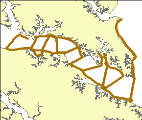
This shapefile represents the 500 shot interval navigation for all the seismic lines collected on this cruise.
Horizontal_Positional_Accuracy:
Horizontal_Positional_Accuracy_Report:
A differential global positioning system (DGPS) was used for the seismic-reflection data. This system was an Ashtech DGPS2 with the navigation being recorded by HYPACK navigation software. The offset from the seismic transducer to the DGPS antenna was 2 meters. This offset was not entered into the software.
Vertical_Positional_Accuracy:
Vertical_Positional_Accuracy_Report:
Although bathymetry was not recorded directly, bathymetry can be derived by tracing the seafloor reflector in the seismic-reflection profiles. The seismic transducers were mounted on an over the side mount on the port side of the ship. The transducer draft was 0.7 m below the water surface. The draft offset was not included in the data acquisition.
Source_Information:
Source_Citation:
Citation_Information:
Originator: U.S. Geological Survey
Publication_Date: Unpublished material
Title: Raw Seismic Data
Type_of_Source_Media: hard disk
Source_Time_Period_of_Content:
Time_Period_Information:
Range_of_Dates/Times:
Beginning_Date: 20060906
Ending_Date: 20060908
Source_Currentness_Reference: ground condition
Source_Citation_Abbreviation: raw seismic data
Source_Contribution:
The seismic acquisition system used on this cruise was a Knudsen Engineering Limited (KEL)1600 USB system. The system has up to 1.2 kW power and is tuned to work with two Massa 3.5 kHz transducers. The transducers were mounted on an over-the-side mount on the port side of the ship. The transducer draft was 0.7 m below the water surface. This draft offset was not included in the data acquisition. The seismic data acquisition software was SounderSuite-USB Beta. This system failed to acquire navigation data from the DGPS NEMA string on the first two days (Julian day 149 and 150). The software was also not able to record data in SEG-Y standard format. KEL KEB format files were logged to disk. In addition, KEA ASCII files with shot (ping) numbers and times were saved to disk. Shot point navigation was also absent in the KEA files on Julian days 149 and 150. On Julian day 151 a patched version of SounderSuite was received and installed. This version recorded navigation in the KEB and KEA files. SEG-Y recording was still not an option. A time server was used to synchronize the DGPS time on the KEL and HYPACK navigation systems. This was important as KEL SounderSuite records system time. Data were acquired at a 20 micro-second sample interval, 2048 samples for a 40 ms record length. Fire-rate was 0.20 seconds (or 5 shots per second). The KEL SounderSuite software was set up to automatically switch files at shot 20,000. Line 5 switched from file 0005_2006_249_2014_002.keb after shot 13509 to a new file (0005_2006_249_2014_003.keb) while changing display parameters, due to a bug in the acquisition software.
Process_Step:
Process_Description:
An ArcView 3.3 avenue script written in Woods Hole (point2line.ave) was used to connect the individual shot points using the attribute "linename" as the unique line identifier. That attribute is also brought over to the resulting polyline shapefile. This process step, as well as all subsequent process steps, were performed by the same person - VeeAnn A. Cross.
Source_Used_Citation_Abbreviation: allshots.shp
Process_Date: 2006
Source_Produced_Citation_Abbreviation: allshots_lns.shp
Process_Contact:
Contact_Information:
Contact_Person_Primary:
Contact_Person: VeeAnn A. Cross
Contact_Organization: U.S. Geological Survey
Contact_Position: Marine Geologist
Contact_Address:
Address_Type: mailing and physical address
Address: Woods Hole Coastal and Marine Science Center
Address: 384 Woods Hole Rd.
City: Woods Hole
State_or_Province: MA
Postal_Code: 02543-1598
Contact_Voice_Telephone: (508) 548-8700 x2251
Contact_Facsimile_Telephone: (508) 457-2310
Contact_Electronic_Mail_Address: [email protected]
Process_Step:
Process_Description:
Using ArcMap 9.0 - ArcToolbox - Data Management Tools - Define Projection the polyline shapefile projection was defined as UTM, zone 18, NAD83.
Source_Used_Citation_Abbreviation: allshots_lns.shp
Process_Date: 2006
Source_Produced_Citation_Abbreviation: allshots_lns.shp
Process_Step:
Process_Description:
The polyline shapefile was converted to a route using ArcMap 9.0 - ArcToolbox - Linear Referencing Tools - Create Routes. The following tool parameters were used: Input line feature - allshots.shp; route identifier field - linename; output route feature class - allshots_route.shp. The rest of the parameters were left to the default values. This process step, as well as all subsequent process steps, were performed by the same person - VeeAnn A. Cross.
Source_Used_Citation_Abbreviation: allshots_lns.shp
Process_Date: 2006
Source_Produced_Citation_Abbreviation: allshots_route.shp
Process_Step:
Process_Description:
This polyline route was then calibrated using ArcMap 9.0 - ArcToolbox - Linear Referencing Tools - Calibrate Routes. The following parameters were used: input route features - allshots_route.shp; route identifier field - linename; input point features - allshots.shp; point identifier field - linename; measure field - shot; output route feature class - allshots_route_Calibrate.shp; measure calculation method - distance; search radius 0. The rest of the parameters left at the default.
Source_Used_Citation_Abbreviation: allshots_route.shp
Source_Used_Citation_Abbreviation: allshots.shp
Process_Date: 2006
Source_Produced_Citation_Abbreviation: allshots_route_Calibrate.shp
Process_Step:
Process_Description:
Added hatches to the calibrated route using ArcMap 9.0 by opening the layer properties and selecting the Hatches tab. Create a hatch interval of 500 for the Hatch Class, then for Hatch Def(1) place a marker hatch every 1 hatch interval. From the Hatch Class Add a Hatch Definition - Add End Hatch Definition and set these to a marker Hatch. By displaying the labels for both Hatch Definitions, a quick comparison between the hatches and shot navigation makes sure things are behaving as intended. Then turn the labels off.
Source_Used_Citation_Abbreviation: allshots_route_Calibrate.shp
Process_Date: 2006
Source_Produced_Citation_Abbreviation: allshots_route_Calibrate.shp
Process_Step:
Process_Description:
Within ArcMap 9.0 - by going to Tools - Customize - Commands and scrolling down to the Category "Linear Referencing", the icon for the command "Convert Hatches to Graphics can be added to a toolbar. Once this is done, that tool can be used to convert the hatches to graphics.
Process_Date: 2006
Process_Step:
Process_Description:
Convert these graphics to a shapefile using XTools Pro version 5.0.
Source_Used_Citation_Abbreviation: displayed graphic points
Process_Date: 2006
Source_Produced_Citation_Abbreviation: shot500graphics.shp
Process_Step:
Process_Description:
Use ArcMap 9.0 - ArcToolbox - Linear Referencing Tools - Locate Features Along Route. The following parameters were used: Input Features:shot500graphics.shp; Input Route Features - allshots_route_Calibrate.shp; route identifier field - linename; Search Radius - 5 meters; output event table - shot500graphics_LocateFeatur.dbf; output route identifier field - linename; measure field - shot. All the rest of the parameters left to the default.
Source_Used_Citation_Abbreviation: shot500graphics.shp
Source_Used_Citation_Abbreviation: allshots_route_Calibrate.shp
Process_Date: 2006
Source_Produced_Citation_Abbreviation: shot500graphics_LocateFeatur.dbf
Process_Step:
Process_Description:
Convert the event layer to a shapefile by exporting the data (right mouse click on event layer, Data, Export Data).
Source_Used_Citation_Abbreviation: shot500graphics_LocateFeatur Events
Process_Date: 2006
Source_Produced_Citation_Abbreviation: shot500tmp.shp
Process_Step:
Process_Description:
Using VACExtras version 1.95 (an ArcMap extension written in Woods Hole) in ArcMap 9.0 the attribute table of the shot navigation was sorted primarily by the attribute linename with a secondary sort field by the attribute shot.
Source_Used_Citation_Abbreviation: shot500tmp.shp
Process_Date: 2006
Source_Produced_Citation_Abbreviation: shot500sort.shp
Process_Step:
Process_Description:
There are lines that show no break between files because the Knudsen was set to record data and automatically switch files every 20,000 shots. This made the last shot of one file the same as the first shot of the subsequent file. This leads to duplicate shot #1 at these bounds during linear referencing. The first shot #1 should really be shot 19999 of the previous file. To account for this, the attributes of the shapefile were edit to reflect this (effectively removing the duplicate shots). So for instance, two records have the linename 0001_2006_249_1447_002 and shot 1. The first record was changed to linename 001_2006_249_1340_001 with shot number 19999. This way, every shot has a unique line number - shot combination.
Source_Used_Citation_Abbreviation: shot500sort.shp
Process_Date: 2006
Source_Produced_Citation_Abbreviation: shot500sort.shp
Process_Step:
Process_Description:
The shot point shapefile was reprojected to Geographic, NAD83 using ArcMap 9.2, ArcToolbox - Data management Tools - Projections and Transformations - Feature - Project. Because the input file and output file have the same datum, no datum transformation was required.
Source_Used_Citation_Abbreviation: shot500sort.shp
Process_Date: 2009
Source_Produced_Citation_Abbreviation: shot500sort_geog.shp
Process_Step:
Process_Description:
Edits to the metadata were made to fix any errors that MP v 2.9.34 flagged. This is necessary to enable the metadata to be successfully harvested for various data catalogs. In some cases, this meant adding text "Information unavailable" or "Information unavailable from original metadata" for those required fields that were left blank. Other minor edits were probably performed (title, publisher, publication place, etc.). The source information was incomplete and had to be modified to meet the standard. The distribution format name was modified in an attempt to be more consistent with other metadata files of the same data format. The metadata date (but not the metadata creator) was edited to reflect the date of these changes. The metadata available from a harvester may supersede metadata bundled within a download file. Compare the metadata dates to determine which metadata file is most recent.
Process_Date: 20161027
Process_Contact:
Contact_Information:
Contact_Organization_Primary:
Contact_Organization: U.S. Geological Survey
Contact_Person: VeeAnn A. Cross
Contact_Position: Marine Geologist
Contact_Address:
Address_Type: Mailing and Physical
Address: 384 Woods Hole Road
City: Woods Hole
State_or_Province: MA
Postal_Code: 02543
Contact_Voice_Telephone: 508-548-8700 x2251
Contact_Facsimile_Telephone: 508-457-2310
Contact_Electronic_Mail_Address: [email protected]
Process_Step:
Process_Description: USGS Thesaurus keywords added to the keyword section.
Process_Date: 20180720
Process_Contact:
Contact_Information:
Contact_Organization_Primary:
Contact_Organization: U.S. Geological Survey
Contact_Person: VeeAnn A. Cross
Contact_Position: Marine Geologist
Contact_Address:
Address_Type: Mailing and Physical
Address: 384 Woods Hole Road
City: Woods Hole
State_or_Province: MA
Postal_Code: 02543-1598
Contact_Voice_Telephone: 508-548-8700 x2251
Contact_Facsimile_Telephone: 508-457-2310
Contact_Electronic_Mail_Address: [email protected]
Process_Step:
Process_Description: Crossref DOI link was added as the first link in the metadata.
Process_Date: 20191118
Process_Contact:
Contact_Information:
Contact_Organization_Primary:
Contact_Organization: U.S. Geological Survey
Contact_Person: VeeAnn A. Cross
Contact_Position: Marine Geologist
Contact_Address:
Address_Type: Mailing and Physical
Address: 384 Woods Hole Road
City: Woods Hole
State_or_Province: MA
Postal_Code: 02543-1598
Contact_Voice_Telephone: 508-548-8700 x2251
Contact_Facsimile_Telephone: 508-457-2310
Contact_Electronic_Mail_Address: [email protected]
Process_Step:
Process_Description:
Added keywords section with USGS persistent identifier as theme keyword.
Process_Date: 20200908
Process_Contact:
Contact_Information:
Contact_Organization_Primary:
Contact_Organization: U.S. Geological Survey
Contact_Person: VeeAnn A. Cross
Contact_Position: Marine Geologist
Contact_Address:
Address_Type: Mailing and Physical
Address: 384 Woods Hole Road
City: Woods Hole
State_or_Province: MA
Postal_Code: 02543-1598
Contact_Voice_Telephone: 508-548-8700 x2251
Contact_Facsimile_Telephone: 508-457-2310
Contact_Electronic_Mail_Address: [email protected]