No additional checks for consistency were performed on this data.
All collected data were processed and used to produce this dataset.
Horizontal_Positional_Accuracy:
Horizontal_Positional_Accuracy_Report:
Horizontal position of the launches acquiring multibeam bathymetry were determined using GPS corrected by U.S. Coast Guard differential GPS beacon stations at Moriches, New York, and Sandy Hook, New Jersey. Real-time positioning during LIDAR acquisition was obtained by an Ashtech GG24 GPS receiver combined with Thales GeoSolutions Wide Area DGPS. Original horizontal resolution of the MBES data was 1 m; the final CARIS combined base surface for the MBES data was produced at a 4-m cell size; original cell size of the gridded LIDAR data was primarily 4 m.
Vertical_Positional_Accuracy:
Vertical_Positional_Accuracy_Report:
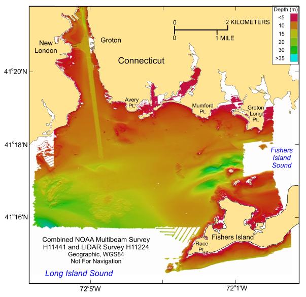
Attitude of the launches (e.g. pitch, roll, and heave) acquiring multibeam bathymetry were monitored by an Applanix TSS POS/MV 320 Version 3 GPS aided navigation system. Real-time positioning during LIDAR acquisition was obtained by an Ashtech GG24 GPS receiver combined with Thales GeoSolutions Wide Area DGPS. Ashtech Z12 GPS receivers, provided as part of the Airborne System and Ground Systems, also logged GPS data on the aircraft and at a locally established base station to provide post processed KGPS position solutions. Received infrared laser energy, supplemented by an Altitude Heading Reference System (AHRS) inertial height reference and kinematic GPS, determined the height of the aircraft. The vertical resolution of the multibeam data is approximately 0.5% of the water depth. Although there are no depth attributes associated with the GeoTIFF image, pixel values convey RGB values of individual cells. Warmer colors (e.g. red) are shallower depths; cooler colors are deeper.
Source_Information:
Source_Citation:
Citation_Information:
Originator: Emily B. Christman
Originator: National Oceanic and Atmospheric Administration
Publication_Date: Unknown
Title: H11441 bathymetry
Geospatial_Data_Presentation_Form: raster digital data
Publication_Information:
Publication_Place: Atlantic Hydrographic Branch, Norfolk, VA
Publisher:
National Ocean Survey, National Oceanic and Atmospheric Administration
Type_of_Source_Media: disc
Source_Time_Period_of_Content:
Time_Period_Information:
Range_of_Dates/Times:
Beginning_Date: 20050427
Ending_Date: 20050522
Source_Currentness_Reference: ground condition
Source_Citation_Abbreviation: Information unavailable from original metadata.
Source_Contribution: Original processed multibeam bathymetric data.
Source_Information:
Source_Citation:
Citation_Information:
Originator: National Oceanic and Atmospheric Administration
Originator: Darren Stephenson
Publication_Date: Unknown
Title: H11224 bathymetry
Geospatial_Data_Presentation_Form: raster digital data
Publication_Information:
Publication_Place: Atlantic Hydrographic Branch, Norfolk, VA
Publisher:
National Ocean Survey, National Oceanic and Atmospheric Administration
Type_of_Source_Media: disc
Source_Time_Period_of_Content:
Time_Period_Information:
Range_of_Dates/Times:
Beginning_Date: 20040120
Ending_Date: 20040305
Source_Currentness_Reference: ground condition
Source_Citation_Abbreviation: Information unavailable from original metadata.
Source_Contribution: Original processed LIDAR bathymetric data.
Process_Step:
Process_Description:
Two 8.5-m aluminum Jensen launches deployed from the NOAA Ship Thomas Jefferson were used to acquire the multibeam echosounder (MBES) bathymetric data for surveys H11441 and H11442 during April - May 2005 off New London, Connecticut. Although most of the deeper parts of these surveys were completely covered during MBES acquisition, coverage in the shallower areas (<10 m) was limited to 'postage stamp' developments around target areas and reconnaissance cross lines. The MBES data were collected with hull-mounted RESON SeaBat 240-kHz 8101 and 455-kHz 8125 shallow-water systems. These systems measure two-way sound travel time across a 150-degree swath and 120-degree swath, respectively. The SeaBat 8101 has 101 beams at a 1.5-degree beam spacing. The SeaBat 8125 has 240 beams with a cross-track beam width of 0.5 degrees at nadir. Original horizontal resolution of the MBES data was 1 m; vertical resolution of the MBES data is about 0.5% of the water depth. The bathymetric data were acquired in XTF (extended Triton data format) and processed by NOAA using CARIS HIPS (Hydrographic Image Processing System) software for quality control, to incorporate sound velocity and tidal corrections, and to produce the continuous digital terrain model. Navigation was by TSS POS/MV 320 differential GPS-assisted inertial navigation systems; the differential GPS beacons used were from Moriches, New York, and Sandy Hook, New Jersey. HYPACK MAX was used for acquisition line navigation. Sound velocity corrections were derived using frequent SEACAT CTD (conductivity-temperature-depth) profiles. Typically, a CTD cast was conducted every four to six hours of MBES acquisition. Tidal zone corrections were calculated from data acquired from National Water Level Observation stations at New London, Connecticut and Montauk, New York. Vertical datum is mean lower low water. Individuals interested in detail descriptions of the MBES acquisition and processing should consult the descriptive reports. Eleven reconnaissance cruises were conducted aboard a leased lobster boat to monitor water clarity prior to commencement of airborne LIDAR operations of surveys H11224 and H11225. These cruises, which utilized Secchi disks to determine water clarity, were conducted between the Connecticut River and Fishers Island during May 9, 2003 and January 11, 2004, when water clarity was deemed adequate. The LIDAR (light detection and ranging) data were acquired by Tenix LADS, Inc. during January 25 - March 3, 2004 with a LADS Mk II system. Airborne survey operations were conducted aboard a Dash 8-202 series aircraft with a Nd:YAG laser at heights between 1,200 and 2,200 feet, at ground speeds between 140 and 210 knots, and at 4x4 and 3x3-m laser-spot spacings. Green laser pulses were scanned beneath the aircraft in a rectilinear pattern. The returned green-laser energy reflected from the sea surface and seafloor were captured and digitally recorded. Received infrared laser energy, supplemented by an Altitude Heading Reference System (AHRS) inertial height reference and kinematic GPS, determined the height of the aircraft. Real-time positioning was provided by WADGPS (wide area differential global positioning system). Acquired data were processed with CARIS HIPS. Individuals interested in detail descriptions of the LIDAR acquisition and processing should consult the descriptive reports. Vertical datum is mean lower low water; X and Y units are meters; UTM Zone 18, NAD83. The final CARIS combined base surfaces were produced at a 4-m cell size for surveys H11441, H11224, and H11225; the final CARIS combined base surface for survey H11442 was produced at a 3-m cell size.
Process_Date: Unknown
Source_Produced_Citation_Abbreviation: H11441 CARIS HIPS database
Source_Produced_Citation_Abbreviation: H11224 CARIS HIPS database
Source_Produced_Citation_Abbreviation: H11442 CARIS HIPS database
Source_Produced_Citation_Abbreviation: H11225 CARIS HIPS database
Process_Contact:
Contact_Information:
Contact_Organization_Primary:
Contact_Organization: National Oceanic and Atmospheric Administration
Contact_Person: Marc Moser
Contact_Position: Field Operations Officer
Contact_Address:
Address_Type: mailing address
Address: 439 West York Street
City: Norfolk
State_or_Province: VA
Postal_Code: 23510
Country: USA
Contact_Voice_Telephone: 757-441-6746
Contact_Electronic_Mail_Address: [email protected]
Process_Step:
Process_Description:
The CARIS field sheets for four surveys were inspected to determine if there was vertical and/or horizontal offsets where the surveys overlapped. NOAA LIDAR surveys (H11224 and H11225) showed no relative offset in either the vertical or horizontal direction. The same was found for the two adjacent NOAA multibeam surveys (H11441 and H11442). However, a consistent 25-cm vertical offset was found between the multibeam and LIDAR data sets, with the multibeam data being consistently 25 cm shallower than the overlapping LIDAR survey. To correct this problem, it was decided that multibeam surveys H11441 and H11442 would be offset (deeper) by 25 cm and thus referenced to LIDAR surveys H11224 and H11225. After reviewing the Data Acquisition and Processing Reports (DAPR) in addition to the Descriptive Report (DR) for each of the 4 surveys, 25 cm is within the vertical error budget as reported by Tenix for the LADS system, and as reported for the Reson 8101 and 8125 systerms installed on the NOAA launches. Vertical control was the same for all surveys. Since the 25 cm offset was not outside of the error analyses for all surveys, it was decided to reference the multibeam data to the LIDAR data by lowering the multibeam depth soundings, mainly to keep the 0 LIDAR depth contour (sea surface as obtained by the LADS system) at sea level, but also because the Tenix LADS surveys were conducted using real-time kinematic GPS techniques and judged to be accurate in the vertical dimension.
Source_Used_Citation_Abbreviation: H11441 CARIS HIPS database
Source_Used_Citation_Abbreviation: H11442 CARIS HIPS database
Source_Used_Citation_Abbreviation: H11224 CARIS HIPS database
Source_Used_Citation_Abbreviation: H11225 CARIS HIPS database
Process_Date: 2009
Process_Contact:
Contact_Information:
Contact_Person_Primary:
Contact_Person: Bill Danforth
Contact_Organization: U.S. Geological Survey
Contact_Position: Geologist
Contact_Address:
Address_Type: mailing and physical address
Address: 384 Woods Hole Road
City: Woods Hole
State_or_Province: MA
Postal_Code: 02543-1598
Contact_Voice_Telephone: 508-548-8700 x2274
Contact_Facsimile_Telephone: 508-457-2310
Contact_Electronic_Mail_Address: [email protected]
Process_Step:
Process_Description:
The field sheets from surveys H11441 and H11224 (average depths, not the shoal based field sheets) were imported into the Fledermaus v6.7 program DMagic to make equivalent digital terrain model (DTM) files. The floating piont format for each sounding depth point is preserved during data import. Additionally, these fieldsheets were imported into DMagic as "gridded data", therefore re-gridding of data did not occur during the import process and thus preserved the original resolutions of the CARIS fieldsheets:
H11441 4 meter cell size
H11224 4 meter cell size
The H11441 DTM file was then exported as an ESRI ASCII raster file from the DMagic program. The export process preserves the floating point values of the grid cell nodes.
Source_Used_Citation_Abbreviation: H11441 CARIS HIPS database
Source_Used_Citation_Abbreviation: H11224 CARIS HIPS database
Process_Date: 2009
Source_Produced_Citation_Abbreviation: h11441.dtm
Source_Produced_Citation_Abbreviation: h11224.dtm
Source_Produced_Citation_Abbreviation: h11441.asc
Process_Contact:
Contact_Information:
Contact_Person_Primary:
Contact_Person: Bill Danforth
Contact_Organization: U.S. Geological Survey
Contact_Position: Geologist
Contact_Address:
Address_Type: mailing and physical address
Address: 384 Woods Hole Road
City: Woods Hole
State_or_Province: MA
Postal_Code: 02543
Country: USA
Contact_Voice_Telephone: 508-548-8700 x2274
Contact_Facsimile_Telephone: 508-457-2310
Contact_Electronic_Mail_Address: [email protected]
Process_Step:
Process_Description:
The ESRI ASCII raster files were imported into ArcMap v9.3 using the ASCII to Raster tool (ArcToolbox, Conversion Tools, To Raster). The only option set here is to import each sounding grid cell value as a floating point number. Subsequently, 25 cm was added to the H11441 raster grid cells, creating a new raster that could now be combined with the LIDAR data sets. The H11441 raster file was then exported out of ArcMap using the Raster to ASCII tool (ArcToolbox, Conversion Tools, From Raster).
Source_Used_Citation_Abbreviation: h11441.asc
Process_Date: 2009
Source_Produced_Citation_Abbreviation: h11441.asc
Process_Contact:
Contact_Information:
Contact_Person_Primary:
Contact_Person: Bill Danforth
Contact_Organization: U.S. Geological Survey
Contact_Position: Geologist
Contact_Address:
Address_Type: mailing and physical address
Address: 384 Woods Hole Road
City: Woods Hole
State_or_Province: MA
Postal_Code: 02543-1598
Contact_Voice_Telephone: 508-548-8700 x2274
Contact_Facsimile_Telephone: 508-457-2310
Contact_Electronic_Mail_Address: [email protected]
Process_Step:
Process_Description:
The adjusted multibeam raster was imported back into the Fledermaus v6.7 DMagic program in order to create a new DTM file that could be combined with the LIDAR DTM file. The floating piont format for each sounding depth point is preserved during data import. Additionally, the data from the ArcGIS ASCII raster files were imported into DMagic as "gridded data", therefore re-gridding of data did not occur during the import process and thus preserved the original resolutions of the CARIS fieldsheets.
Source_Used_Citation_Abbreviation: h11441.asc
Process_Date: 2009
Source_Produced_Citation_Abbreviation: h11441.dtm
Process_Contact:
Contact_Information:
Contact_Person_Primary:
Contact_Person: Bill Danforth
Contact_Organization: U.S. Geological Survey
Contact_Position: Geologist
Contact_Address:
Address_Type: mailing and physical address
Address: 384 Woods Hole Road
City: Woods Hole
State_or_Province: MA
Postal_Code: 02543-1598
Contact_Voice_Telephone: 508-548-8700 x2274
Contact_Facsimile_Telephone: 508-457-2310
Contact_Electronic_Mail_Address: [email protected]
Process_Step:
Process_Description:
The DTM files from surveys H11441 (now 25 cm deeper) and H11224 were combined into one 4-m grid file using the Fledermaus command line option dtmmerge, and the combined H11441-H11224 grid was exported from DMagic as an ESRI ASCII raster file. The dtmmerge option combines the input grid files and sets the resolution of the output combined grid to the lowest resolution input grid, in this case the 4-meter LIDAR grid. Additionally the output soundings for the combined grid is based on the average of the nearest input grid soundings for a particular output grid cell. The command line used was:
dtmmerge -in h11224.dtm h11441.dtm -out nlondon.dtm -cellsize 4.0 -mode average
Source_Used_Citation_Abbreviation: h11441.dtm
Source_Used_Citation_Abbreviation: h11224.dtm
Process_Date: 2009
Source_Produced_Citation_Abbreviation: nlondon.asc
Process_Contact:
Contact_Information:
Contact_Person_Primary:
Contact_Person: Bill Danforth
Contact_Organization: U.S. Geological Survey
Contact_Position: Geologist
Contact_Address:
Address_Type: mailing and physical address
Address: 384 Woods Hole Road
City: Woods Hole
State_or_Province: MA
Postal_Code: 02543-1598
Contact_Voice_Telephone: 508-548-8700 x2274
Contact_Facsimile_Telephone: 508-457-2310
Contact_Electronic_Mail_Address: [email protected]
Process_Step:
Process_Description:
The ESRI ASCII raster file was then converted into raster within ArcToolbox v9.3 using the ASCII to Raster conversion tool, and reprojected using the data management tool Project Raster (ArcToolbox, Data Management Tools, Projections and Transformations) from UTM Zone 18N, NAD 83 to Geographic, WGS84. The options specified in the Project Raster tool were:
1. Input coordinate system: NAD_1983_UTM_Zone_18N
2. Output coordinate system: GCS_WGS_1984
3. Geographic transformation method: NAD_1983_WGS_1984_5
4. Resampling technique: BILINEAR
5. Output cell size: 0.000043 (decimal degrees, default as calculated by ArcMap for a 4 meter cell size)
The geographic transformation selected is the most accurate one provided by ESRI as it ties in WGS84 with ITRF96, thus reflecting the earth centered offset (x-y-z) between WGS84 and NAD83 (from the ESRI Knowledge Base Document Number 24159).
Source_Used_Citation_Abbreviation: nlondon.asc
Process_Date: 2009
Source_Produced_Citation_Abbreviation: nlondon_geo
Process_Contact:
Contact_Information:
Contact_Person_Primary:
Contact_Person: Bill Danforth
Contact_Organization: U.S. Geological Survey
Contact_Position: Geologist
Contact_Address:
Address_Type: mailing and physical address
Address: 384 Woods Hole Road
City: Woods Hole
State_or_Province: MA
Postal_Code: 02543-1598
Contact_Voice_Telephone: 508-548-8700 x2274
Contact_Facsimile_Telephone: 508-457-2310
Contact_Electronic_Mail_Address: [email protected]
Process_Step:
Process_Description:
A color, hill-shaded GeoTIFF images with world file was created within DMagic and IVS Image Viewer. Sun illumination is from the north at 45 degrees above the horizon, and vertical exaggeration is 4x.
Source_Used_Citation_Abbreviation: nlondon_geo
Process_Date: 2009
Source_Produced_Citation_Abbreviation: nlondon_mblidar_geo.tif
Source_Produced_Citation_Abbreviation: nlondon_mblidar_geo.tfw
Process_Contact:
Contact_Information:
Contact_Person_Primary:
Contact_Person: Bill Danforth
Contact_Organization: U.S. Geological Survey
Contact_Position: Geologist
Contact_Address:
Address_Type: mailing and physical address
Address: 384 Woods Hole Road
City: Woods Hole
State_or_Province: MA
Postal_Code: 02543-1598
Contact_Voice_Telephone: 508-548-8700 x2274
Contact_Facsimile_Telephone: 508-457-2310
Contact_Electronic_Mail_Address: [email protected]
Process_Step:
Process_Description:
Edits to the metadata were made to fix any errors that MP v 2.9.32 flagged. This is necessary to enable the metadata to be successfully harvested for various data catalogs. In some cases, this meant adding text "Information unavailable" or "Information unavailable from original metadata" for those required fields that were left blank. Other minor edits were probably performed (title, publisher, publication place, etc.). In the case of the depth resolution, the value of 9999 was entered to indicate that the original metadata did not contain the required information. The metadata date (but not the metadata creator) was edited to reflect the date of these changes. The metadata available from a harvester may supersede metadata bundled within a download file. Compare the metadata dates to determine which metadata file is most recent.
Process_Date: 20160412
Process_Contact:
Contact_Information:
Contact_Organization_Primary:
Contact_Organization: U.S. Geological Survey
Contact_Person: VeeAnn A. Cross
Contact_Position: Marine Geologist
Contact_Address:
Address_Type: mailing and physical address
Address: 384 Woods Hole Rd.
City: Woods Hole
State_or_Province: MA
Postal_Code: 02543
Contact_Voice_Telephone: 508-548-8700 x2251
Contact_Facsimile_Telephone: 508-457-2310
Contact_Electronic_Mail_Address: [email protected]
Process_Step:
Process_Description: USGS Thesaurus keywords added to the keyword section.
Process_Date: 20180720
Process_Contact:
Contact_Information:
Contact_Organization_Primary:
Contact_Organization: U.S. Geological Survey
Contact_Person: VeeAnn A. Cross
Contact_Position: Marine Geologist
Contact_Address:
Address_Type: Mailing and Physical
Address: 384 Woods Hole Road
City: Woods Hole
State_or_Province: MA
Postal_Code: 02543-1598
Contact_Voice_Telephone: 508-548-8700 x2251
Contact_Facsimile_Telephone: 508-457-2310
Contact_Electronic_Mail_Address: [email protected]
Process_Step:
Process_Description: Crossref DOI link was added as the first link in the metadata.
Process_Date: 20191118
Process_Contact:
Contact_Information:
Contact_Organization_Primary:
Contact_Organization: U.S. Geological Survey
Contact_Person: VeeAnn A. Cross
Contact_Position: Marine Geologist
Contact_Address:
Address_Type: Mailing and Physical
Address: 384 Woods Hole Road
City: Woods Hole
State_or_Province: MA
Postal_Code: 02543-1598
Contact_Voice_Telephone: 508-548-8700 x2251
Contact_Facsimile_Telephone: 508-457-2310
Contact_Electronic_Mail_Address: [email protected]
Process_Step:
Process_Description:
Added keywords section with USGS persistent identifier as theme keyword.
Process_Date: 20200908
Process_Contact:
Contact_Information:
Contact_Organization_Primary:
Contact_Organization: U.S. Geological Survey
Contact_Person: VeeAnn A. Cross
Contact_Position: Marine Geologist
Contact_Address:
Address_Type: Mailing and Physical
Address: 384 Woods Hole Road
City: Woods Hole
State_or_Province: MA
Postal_Code: 02543-1598
Contact_Voice_Telephone: 508-548-8700 x2251
Contact_Facsimile_Telephone: 508-457-2310
Contact_Electronic_Mail_Address: [email protected]