Information unavailable from original metadata. Assumed to be USGS., unknown, Information unavailable from original metadata..
Type_of_Source_Media: Information unavailable from original metadata.
Source_Contribution:
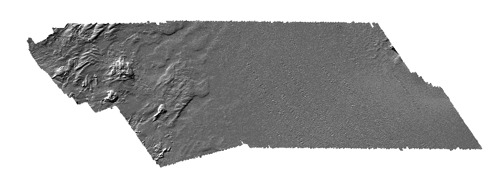
Sonar Configuration: Bathymetry data were acquired using a Systems Engineering and Assessment Ltd. (SEA) SWATHplus interferometric sonar operating at 234 kHz (06012, 07001, 08002) or 117 kHz (07002). Survey lines were run at an average speed of 5 knots and were spaced 75-200 m apart to obtain overlapping swaths of data and full coverage of the seafloor. During USGS field activities 06012 and 07002, the SWATHplus transducers were mounted on a rigid pole on the starboard side of the R/V Megan Miller, about 2.6 m below the waterline.
During 06012, a TSS DMS 2-05 motion reference unit was mounted directly above the sonar transducers and continuously recorded and sent vertical displacement (heave) and attitude (pitch and roll) of the vessel during acquisition to the SWATHplus software. During 06012 vessel heading was determined by a KVH compass that was corrected for magnetic variation of +15.583 degrees (from NOAA Chart number13246 36th ed., Mar. 10/01) during post processing. During 07002, a Coda Octopus F180 inertial-motion unit, mounted directly above the transducers, measured true heading, vertical displacement (heave) and attitude (pitch and roll) of the vessel during acquisition.
Field activities 07001 and 08002: the SWATHplus transducers were mounted on a rigid pole on the bow of the R/V Rafael, about 0.5 m below the waterline. A Coda Octopus F180 inertial-motion unit, mounted directly above the transducers, measured true heading, vertical displacement (heave) and attitude (pitch and roll) of the vessel during acquisition.
Navigation:
Field activity 06012: Real-Time Kinematic (RTK) GPS navigation was used to determine the horizontal and vertical position (xyz) of the GPS antenna mounted directly above the SWATHplus transducers with sub-meter accuracy. The RTK-corrected coordinates were transmitted to the ship from a land-based RTK-GPS station established by the USGS at NOAA Tidal Station #8446009 in Brant Rock Harbor, MA.
Field activities 07001, 07002, and 08002: Differential GPS (DGPS) navigation was used to determine the horizontal position (x,y) of the GPS antenna mounted directly above and forward (F180R primary antenna, 0.5 meters) of the SWATHplus transducers with +/- 1-2 meter accuracy. RTK-GPS was used to determine the vertical position of the Ashtech GPS antenna (z) with sub-meter accuracy.
Vertical coordinates for all four surveys were referenced to Mean Lower Low Water (MLLW) using the offset between the North American Vertical Datum of 1988 (NAVD 88) and MLLW published for the tidal benchmark. Horizontal (x and y) and vertical (z) offsets between the transducers, motion sensor, and GPS antenna were precisely measured and recorded within the SWATHplus acquisition software (SEA Swath Processor (2005)), which established the motion sensor as the common reference point during data acquisition.
Speed of Sound:
Sound-velocity profiles were collected approximately every 2 hours by a hand-casted Applied MicroSystems SV Plus sound velocimeter. The depth of the transducers below the sea surface was measured and recorded within the SWATHplus acquisition software, and used as a reference point for deriving the acoustic ray path based on sound velocity profiles.
Tides: During post-processing, soundings were referenced to local MLLW by using orthometric to chart datum offsets obtained from NOAA Tidal Station #8446009 at Brant Rock Harbor, Massachusetts. Data were processed and gridded by using the SEA SWATHplus Swath Processor (version 10.0) CARIS Hydrographic Information Processing System (HIPS version 6.1).