2-m Bathymetric Grid of National Oceanic and Atmospheric Administration (NOAA) Survey H11251 Offshore of Rocky Point, New York (H11251_2M_GEO, Geographic, WGS84)

Metadata also available as - [Outline] - [Parseable text] - [XML]

Frequently anticipated questions:


What does this data set describe?

Title:
2-m Bathymetric Grid of National Oceanic and Atmospheric Administration (NOAA) Survey H11251 Offshore of Rocky Point, New York (H11251_2M_GEO, Geographic, WGS84)
Abstract:
The U.S. Geological Survey (USGS), in cooperation with the National Oceanic and Atmospheric Administration (NOAA), is producing detailed geologic maps of the coastal sea floor. Bathymetry and sidescan-sonar imagery, originally collected by NOAA for charting purposes, provides a fundamental framework for research and management activities in Long Island Sound, shows the composition and terrain of the seabed, and provides information on sediment transport and benthic habitat. During October 2008 NOAA completed hydrographic survey H11251 offshore of Rocky Point, New York and during November 2009, bottom photographs and surficial sediment data were acquired as part of a ground-truth reconnaissance survey of this area. Interpretive data layers were derived from the multibeam echo-sounder and sidescan-sonar data and the ground-truth data used to verify them. For more information on the ground-truth survey see https://cmgds.marine.usgs.gov/fan_info.php?fan=2009-059-FA
  1. How might this data set be cited?
    National Oceanic and Atmospheric Administration, and U.S. Geological Survey, 2010, 2-m Bathymetric Grid of National Oceanic and Atmospheric Administration (NOAA) Survey H11251 Offshore of Rocky Point, New York (H11251_2M_GEO, Geographic, WGS84): Open-File Report 2010-1007, U.S. Geological Survey, Coastal and Marine Geology Program, Woods Hole Coastal and Marine Science Center, Woods Hole, MA.

    Online Links:

    This is part of the following larger work.

    Poppe, L.J., McMullen, K.Y., Ackerman, S.D., Blackwood, D.S., Irwin, B.J., Schaer, J.D., Lewit, P.G., and Doran, E.F., 2010, Sea-floor geology and character offshore of Rocky Point, New York: Open-File Report 2010-1007, U.S. Geological Survey, Reston, VA.

    Online Links:

    Other_Citation_Details: 1 DVD-ROM
  2. What geographic area does the data set cover?
    West_Bounding_Coordinate: -72.411309
    East_Bounding_Coordinate: -72.318097
    North_Bounding_Coordinate: 41.163127
    South_Bounding_Coordinate: 41.100850
  3. What does it look like?
    http://pubs.usgs.gov/of/2010/1007/data/bathy/grids/geo/h11251_2m_geo.gif (JPEG)
    Thumbnail image showing the 2-m gridded multibeam bathymetry collected during NOAA survey H11251 in Geographic, WGS84
  4. Does the data set describe conditions during a particular time period?
    Beginning_Date: 07-Oct-2008
    Ending_Date: 27-Oct-2008
    Currentness_Reference:
    ground condition
  5. What is the general form of this data set?
    Geospatial_Data_Presentation_Form: raster digital data
  6. How does the data set represent geographic features?
    1. How are geographic features stored in the data set?
      This is a Raster data set. It contains the following raster data types:
      • Dimensions 2919 x 4369 x 1, type Grid Cell
    2. What coordinate system is used to represent geographic features?
      Horizontal positions are specified in geographic coordinates, that is, latitude and longitude. Latitudes are given to the nearest 0.000021. Longitudes are given to the nearest 0.000021. Latitude and longitude values are specified in Decimal degrees. The horizontal datum used is D_WGS_1984.
      The ellipsoid used is WGS_1984.
      The semi-major axis of the ellipsoid used is 6378137.000000.
      The flattening of the ellipsoid used is 1/298.257224.
      Vertical_Coordinate_System_Definition:
      Depth_System_Definition:
      Depth_Datum_Name: Mean lower low water
      Depth_Resolution: 0.1
      Depth_Distance_Units: meters
      Depth_Encoding_Method: Explicit depth coordinate included with horizontal coordinates
  7. How does the data set describe geographic features?
    Entity_and_Attribute_Overview:
    A 2-m grid of the multibeam bathymetry from NOAA survey H11251 in a geographic coordinate system.
    Entity_and_Attribute_Detail_Citation: U.S. Geological Survey

Who produced the data set?

  1. Who are the originators of the data set? (may include formal authors, digital compilers, and editors)
    • National Oceanic and Atmospheric Administration
    • U.S. Geological Survey
  2. Who also contributed to the data set?
  3. To whom should users address questions about the data?
    U.S. Geological Survey
    Attn: Larry Poppe
    Geologist
    384 Woods Hole Road
    Woods Hole, MA
    USA

    (508) 548-8700 x2314 (voice)
    (508) 457-2310 (FAX)
    lpoppe@usgs.gov

Why was the data set created?

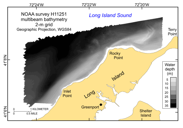
To release a 2-m grid of the multibeam bathymetry generated during NOAA survey H11251 offshore of Rocky Point, New York in geographic, WGS84.

How was the data set created?

  1. From what previous works were the data drawn?
    Information unavailable from original metadata. (source 1 of 1)
    National Ocean Survey, National Oceanic and Atmospheric Administration, Unpublished Material, H112511 bathymetry.

    Type_of_Source_Media: disc
    Source_Contribution: Original processed multibeam bathymetric data.
  2. How were the data generated, processed, and modified?
    Date: 2008 (process 1 of 10)
    Two 8.5-m aluminum Jensen launches and the NOAA Ship Thomas Jefferson were used to acquire the multibeam echosounder (MBES) bathymetric data for survey H11251 during October 2008 offshore of Rocky Point, New York. The launch MBES data were collected with hull-mounted RESON SeaBat 240-kHz 8101 and 455-kHz 8125 shallow-water systems. These systems measure two-way sound travel time across a 150-degree swath and 120-degree swath, respectively. The SeaBat 8101 has 101 beams at a 1.5-degree beam spacing. The SeaBat 8125 has 240 beams with a cross-track beam width of 0.5 degrees at nadir. The ship's MBES data were collected with a RESON 7125 system which measured two-way sound travel time across a 140-degree swath. Original horizontal resolution of the MBES data was 0.5 m for depths less than 20 m and 2 m for the deeper areas. Vertical resolution of the MBES data is about 0.5% of the water depth. The bathymetric data were acquired in XTF (extended Triton data format) and processed by NOAA using CARIS HIPS (Hydrographic Image Processing System) software for quality control, to incorporate sound velocity and tidal corrections, and to produce the continuous digital terrain model. All positioning and attitude were determined with Trimble DSM212L DGPS receivers and Applanix POS/MV Model 320 v.4 inertial navigation systems; HYPACK MAX was used for acquisition line navigation. Sound velocity corrections were derived using frequent SEACAT CTD (conductivity-temperature-depth) profiles. Typically, a CTD cast was conducted every three to four hours of MBES acquisition. Tidal zone corrections were calculated from data acquired from National Water Level Observation stations at New London and New Haven, Connecticut. Vertical datum is mean lower low water. Individuals interested in detail descriptions of the MBES acquisition and processing should consult the descriptive reports. The data were gridded to 2-m resolution and saved as a CARIS HIPS database in UTM Zone 18, NAD83. Person who carried out this activity:
    National Oceanic and Atmospheric Administration
    Attn: Jasper Schare
    Field Operations Officer
    439 West York Street
    Norfolk, VA
    USA

    757-441-6746 (voice)
    jasper.schaer@noaa.gov
    Data sources produced in this process:
    • H11251 CARIS HIPS database
    Date: 2009 (process 2 of 10)
    Converted the Fieldsheet file (h11251_ahb_2m_combined) from the NOAA CARIS database to a DTM file using IVS DMagic v6.7. The floating point format for each sounding depth point is preserved during data import. These fieldsheets were imported into DMagic as "gridded data", therefore re-gridding of data did not occur during the import process and thus preserved the original resolutions of the CARIS fieldsheet. Person who carried out this activity:
    Seth Ackerman
    U.S. Geological Survey
    GIS Specialist
    384 Woods Hole Road
    Woods Hole, MA

    508-548-8700 x2315 (voice)
    508-457-2310 (FAX)
    sackerman@usgs.gov
    Data sources used in this process:
    • H11251 CARIS HIPS database
    Data sources produced in this process:
    • h11251_ahb_2m_combined.dtm
    Date: 2009 (process 3 of 10)
    he H11251 DTM file was then exported as an ESRI ASCII raster file from the DMagic v6.7 program. Person who carried out this activity:
    Seth Ackerman
    U.S. Geological Survey
    GIS Specialist
    384 Woods Hole Road
    Woods Hole, MA
    USA

    508-548-8700 x2315 (voice)
    508-457-2310 (FAX)
    sackerman@usgs.gov
    Data sources used in this process:
    • h11251_ahb_2m_combined.dtm
    Data sources produced in this process:
    • h11251_ahb_2m_combined.asc
    Date: 2009 (process 4 of 10)
    The ESRI ASCII raster file was then imported into ArcCatalog v9.3 and converted to an ESRI 32-bit floating point grid using the ASCII to Raster conversion tool (ArcToolbox - Conversion Tools - To Raster - ASCII to Raster). Person who carried out this activity:
    Seth Ackerman
    U.S. Geological Survey
    GIS Specialist
    384 Woods Hole Road
    Woods Hole, MA

    508-548-8700 x2315 (voice)
    508-457-2310 (FAX)
    ackerman@usgs.gov
    Data sources used in this process:
    • h11251_ahb_2m_combined.asc
    Data sources produced in this process:
    • h11251_2m_utm
    Date: 2009 (process 5 of 10)
    Defined the projection as UTM Zone 18, NAD83 using ArcCatalog v9.3 (ArcToolbox - Data Management Tools - Projections and Transformations - Define Projection). Person who carried out this activity:
    Seth Ackerman
    U.S. Geological Survey
    GIS Specialist
    384 Woods Hole Road
    Woods Hole, MA

    508-548-8700 x2315 (voice)
    508-457-2310 (FAX)
    sackerman@usgs.gov
    Data sources used in this process:
    • h11251_2m_utm
    Data sources produced in this process:
    • h11251_2m_utm
    Date: 2009 (process 6 of 10)
    The UTM grid was reprojected into a geographic grid, WGS84 using ArcCatalog v9.3 using Data Management Tools, Projections and Transformations, Raster, Project Raster). The resampling technique was bilinear; the transformation was NAD_1983_To_WGS_1984_1 #; other used parameters were defaults. Person who carried out this activity:
    Seth Ackerman
    U.S. Geological Survey
    GIS Specialist
    384 Woods Hole Road
    Woods Hole, MA

    508-548-8700 x2315 (voice)
    508-457-2310 (FAX)
    sackerman@usgs.gov
    Data sources used in this process:
    • h11251_2m_utm
    • h11224.dtm
    Data sources produced in this process:
    • h11251_2m_geo
    Date: 08-Mar-2016 (process 7 of 10)
    Edits to the metadata were made to fix any errors that MP v 2.9.32 flagged. This is necessary to enable the metadata to be successfully harvested for various data catalogs. In some cases, this meant adding text "Information unavailable" or "Information unavailable from original metadata" for those required fields that were left blank. Other minor edits were probably performed (title, publisher, publication place, etc.). The distribution format name was modified in an attempt to be more consistent with other metadata files of the same data format. The metadata date (but not the metadata creator) was edited to reflect the date of these changes. The metadata available from a harvester may supersede metadata bundled within a download file. Compare the metadata dates to determine which metadata file is most recent. Person who carried out this activity:
    U.S. Geological Survey
    Attn: VeeAnn A. Cross
    Marine Geologist
    384 Woods Hole Rd.
    Woods Hole, MA

    508-548-8700 x2251 (voice)
    508-457-2310 (FAX)
    vatnipp@usgs.gov
    Date: 14-Feb-2017 (process 8 of 10)
    Keywords section of metadata optimized for discovery in USGS Coastal and Marine Geology Data Catalog. Person who carried out this activity:
    U.S. Geological Survey
    Attn: Alan O. Allwardt
    Contractor -- Information Specialist
    2885 Mission Street
    Santa Cruz, CA

    831-460-7551 (voice)
    831-427-4748 (FAX)
    aallwardt@usgs.gov
    Date: 18-Nov-2019 (process 9 of 10)
    Crossref DOI link was added as the first link in the metadata. Person who carried out this activity:
    U.S. Geological Survey
    Attn: VeeAnn A. Cross
    Marine Geologist
    384 Woods Hole Road
    Woods Hole, MA

    508-548-8700 x2251 (voice)
    508-457-2310 (FAX)
    vatnipp@usgs.gov
    Date: 08-Sep-2020 (process 10 of 10)
    Added keywords section with USGS persistent identifier as theme keyword. Person who carried out this activity:
    U.S. Geological Survey
    Attn: VeeAnn A. Cross
    Marine Geologist
    384 Woods Hole Road
    Woods Hole, MA

    508-548-8700 x2251 (voice)
    508-457-2310 (FAX)
    vatnipp@usgs.gov
  3. What similar or related data should the user be aware of?
    Schattgen, P. Tod, 2008, H11251: Descriptive Report H11251, National Ocean Survey, National Oceanic and Atmospheric Administration, Atlantic Hydrographic Branch, Norfolk, VA.

    Online Links:

    Poppe, L.J., DiGiacomo-Cohen, M.L., Doran, E.F., Smith, S.M., Stewart, H.F., and Forfinski, N.A., 2007, Geological interpretation and multibeam bathymetry of the sea floor in the vicinity of the Race, eastern Long Island Sound: Open-File Report 2007-1012, U.S. Geological Survey, Reston, VA.

    Online Links:

    Poppe, L.J., Denny, J.F., Williams, S.J., Moser, M.S., Forfinski, N.A., Stewart, H.F., and Doran, E.F., 2007, The geology of Six Mile Reef, eastern Long Island Sound: Open-File Report 2007-1191, U.S. Geological Survey, Reston, VA.

    Online Links:

    McMullen, K.Y., Poppe, L.J., Danforth, W.W., Blackwood, D.S., Schaer, J.D., Ostapenko, A.J., Glomb, K.A., and Doran, E.F., 2010, Surficial geology of the sea floor in Long Island Sound offshore of Plum Island, New York: Open-File Report 2010-1005, U.S. Geological Survey, Reston, VA.

    Online Links:


How reliable are the data; what problems remain in the data set?

  1. How well have the observations been checked?
  2. How accurate are the geographic locations?
    Horizontal position of the ship and launches acquiring multibeam bathymetry were determined differential GPS. Real-time original horizontal resolution of the MBES data was 0.5 m for depths less than 20 m and 2 m for the deeper areas; the final CARIS combined base surface for the MBES data were produced at a 2-m cell size.
  3. How accurate are the heights or depths?
    Attitude of the vessels (e.g. pitch, roll, and heave) acquiring multibeam bathymetry were monitored by Applanix TSS POS/MV 320 Version 3 GPS aided navigation systems. The vertical resolution of the original bathymetry data is approximately 0.5% of the water depth.
  4. Where are the gaps in the data? What is missing?
    All collected data were processed and used to produce this dataset.
  5. How consistent are the relationships among the observations, including topology?
    No additional checks for consistency were performed on this data.

How can someone get a copy of the data set?

Are there legal restrictions on access or use of the data?
Access_Constraints: None
Use_Constraints:
Data are not to be used for navigation purposes. Public domain data are freely redistributable with proper metadata and source attribution. Please recognize the National Oceanic and Atmospheric Administration (NOAA) and U.S. Geological Survey (USGS) as the originators of this information.
  1. Who distributes the data set? (Distributor 1 of 1)
    U.S. Geological Survey
    Attn: Larry Poppe
    Geologist
    384 Woods Hole Road
    Woods Hole, MA
    USA

    (508) 548-8700 x2314 (voice)
    (508) 457-2310 (FAX)
    lpoppe@usgs.gov
  2. What's the catalog number I need to order this data set? Downloadable Data
  3. What legal disclaimers am I supposed to read?
    Neither the U.S. Government, the Department of the Interior, nor the USGS, nor the National Oceanic and Atmospheric Administration (NOAA), nor the Connecticut Department of Environmental Protection (CT DEP) nor any of their employees, contractors, or subcontractors, make any warranty, express or implied, nor assume any legal liability or responsibility for the accuracy, completeness, or usefulness of any information, apparatus, product, or process disclosed, nor represent that its use would not infringe on privately owned rights. The act of distribution shall not constitute any such warranty, and no responsibility is assumed by the USGS, NOAA, or the CT DEP in the use of these data or related materials. Any use of trade, product, or firm names is for descriptive purposes only and does not imply endorsement by the U.S. Government.
  4. How can I download or order the data?
  5. What hardware or software do I need in order to use the data set?
    The user must have a program capable of reading the ESRI grid data format. The user must have software capable of uncompressing archived zip files, such as WinZip or Pkware. The directory structure as it appears in the WinZip file must be maintained or else the binary grid is unusable.

Who wrote the metadata?

Dates:
Last modified: 16-Nov-2021
Metadata author:
Larry Poppe
U.S. Geological Survey
Geologist
384 Woods Hole Road
Woods Hole, MA
USA

(508) 548-8700 x2314 (voice)
(508) 457-2310 (FAX)
whsc_data_contact@usgs.gov
Contact_Instructions:
The metadata contact email address is a generic address in the event the metadata contact is no longer with the USGS or the email is otherwise invalid.
Metadata standard:
FGDC Content Standards for Digital Geospatial Metadata (FGDC-STD-001-1998)

This page is <https://cmgds.marine.usgs.gov/catalog/whcmsc/open_file_report/ofr2010-1007/h11251_2m_geo.grd.faq.html>
Generated by mp version 2.9.50 on Tue Nov 16 10:06:38 2021