Online Links:
Online Links:
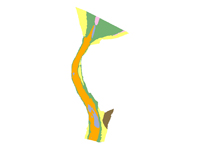
| Value | Definition |
|---|---|
| Qu - Muddy Sand | Quaternary undifferentiated deposit consisting of muddy sand |
| Qu - Sand | Quaternary undifferentiated deposit consisting of sand |
| Qu - Sand and Gravel | Quaternary undifferentiated deposit consisting of sand and gravel |
| Qu - Gravel, cobbles | Quaternary undifferentiated deposit consisting of gravel and cobbles |
| Qu (Qgl) - Silty Clay | Quaternary undifferentiated glaciolacustrine deposit consisting of silty clay |
| Qd - Silty Clay | Quaternary glacial drift consisting of silty clay |
Online Links:
Online Links:
| Access_Constraints | None |
|---|---|
| Use_Constraints | Public domain data from the U.S. Government are freely redistributable with proper metadata and source attribution. Please recognize the U.S. Geological Survey as the originator of the dataset. |
| Data format: | WinZip (version 9.0) file containing a shapefile and layer file describing the surficial geology within the St. Clair river and associated metadata. in format Shapefile (version ArcGIS 9.2) Size: 1 |
|---|---|
| Network links: |
https://pubs.usgs.gov/of/2010/1035/gis_catalog/geology/surf_geol.zip |