Citation:
Citation_Information:
Originator: U.S. Geological Survey
Publication_Date: 2012
Title:
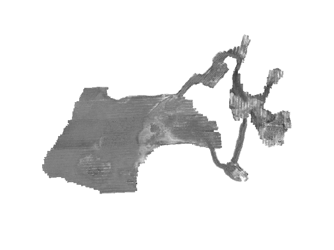
GeoTIFF image of interferometric backscatter data collected by the USGS within Red Brook Harbor, MA, 2009 (RB_Backscatter_5m)
Edition: 1.0
Geospatial_Data_Presentation_Form: remote-sensing image
Series_Information:
Series_Name: Open-File Report
Issue_Identification: 2010-1091
Publication_Information:
Publication_Place:
Woods Hole Coastal and Marine Science Center, Woods Hole, Massachusetts
Publisher: U.S. Geological Survey, Coastal and Marine Geology Program
Online_Linkage: https://doi.org/10.3133/ofr20101091
Online_Linkage:
Online_Linkage: http://pubs.usgs.gov/of/2010/1091/html/appendix1.html
Larger_Work_Citation:
Citation_Information:
Originator: Aaron M. Turecek
Originator: William W. Danforth
Originator: Wayne E. Baldwin
Originator: Walter A. Barnhardt
Publication_Date: 2012
Title:
High-Resolution Geophysical Data Collected Within Red Brook Harbor, Buzzards Bay, Massachusetts, in 2009
Edition: 1.0
Geospatial_Data_Presentation_Form: raster digital data
Series_Information:
Series_Name: Open-File Report
Issue_Identification: 2010-1091
Publication_Information:
Publication_Place: Reston, VA
Publisher: U.S. Geological Survey
Online_Linkage: http://pubs.usgs.gov/of/2010/1091/
Description:
Abstract:
These data were collected under a cooperative agreement with the Massachusetts Office of Coastal Zone Management (CZM) and the U.S. Geological Survey (USGS), Woods Hole Coastal and Marine Science Center (WHCMSC). Initiated in 2003, the primary objective of this program is to develop regional geologic framework information for the management of coastal and marine resources. Accurate data and maps of sea-floor geology are important first steps toward protecting fish habitat, delineating marine resources, and assessing environmental changes due to natural or human impacts. The project is focused on the inshore waters (5-30 m deep) of Massachusetts between the New Hampshire border and Cape Cod Bay. Data collected for the mapping cooperative have been released in a series of USGS Open-File Reports (
http://woodshole.er.usgs.gov/project-pages/coastal_mass/). This is the spatial dataset for the Red Brook Harbor survey area within Buzzards Bay, Massachusetts. These data are the results of a high-resolution geophysical (bathymetry, backscatter intensity, and seismic reflection) and ground validation (sediment samples and bottom photographs) survey, conducted in 2009.
In addition to inclusion within the USGS-CZM geologic mapping effort, these Red Brook Harbor data will be used to assess the shallow-water mapping capability of the geophysical systems deployed for this project, with an emphasis on identifying resolution benchmarks for the interferometric sonar system. (
http://woodshole.er.usgs.gov/operations/ia/public_ds_info.php?fa=2009-018-FA)
This GeoTIFF image represents approximately 7 square kilometers of interferometric sonar backscatter data that were collected in Red Brook Harbor, Massachusetts, by the U.S. Geological Survey in 2009 as part of USGS survey 09018. Data were collected with a Systems Engineering and Assessment Ltd. (SEA) SWATHplus interferometric sonar system. These data are used to define the sea-floor morphology as part of the Massachusetts Sea-floor Mapping Project. The cell size for this image is 5-meter by 5-meter.
Time_Period_of_Content:
Time_Period_Information:
Range_of_Dates/Times:
Beginning_Date: 20090928
Ending_Date: 20091023
Currentness_Reference:
ground condition, data were not collected every day during range
Status:
Progress: Complete
Maintenance_and_Update_Frequency: None planned
Spatial_Domain:
Bounding_Coordinates:
West_Bounding_Coordinate: -70.679515
East_Bounding_Coordinate: -70.616288
North_Bounding_Coordinate: 41.694196
South_Bounding_Coordinate: 41.658297
Keywords:
Theme:
Theme_Keyword_Thesaurus: USGS Metadata Identifier
Theme_Keyword: USGS:0fdb65f8-3cf7-4690-8bea-9cae8fba8800
Theme:
Theme_Keyword_Thesaurus: None
Theme_Keyword: U.S. Geological Survey
Theme_Keyword: USGS
Theme_Keyword: Coastal and Marine Geology Program
Theme_Keyword: CMGP
Theme_Keyword: Woods Hole Coastal and Marine Science Center
Theme_Keyword: WHCMSC
Theme_Keyword: Seafloor
Theme_Keyword: Marine Geology
Theme_Keyword: WHSC field activity serial number 09018
Theme_Keyword: WHCMSC Field Activity 2009-018-FA
Theme_Keyword: bathymetry
Theme_Keyword: swath bathymetry
Theme_Keyword: interferometry
Theme_Keyword: SEA SWATHplus
Theme_Keyword: SEA Submetrix
Theme_Keyword: R/V Rafael
Theme_Keyword: backscatter
Theme_Keyword: GeoTIFF image
Theme:
Theme_Keyword_Thesaurus: ISO 19115 Topic Category
Theme_Keyword: oceans
Theme_Keyword: imageryBaseMapsEarthCover
Theme_Keyword: geoscientificInformation
Theme:
Theme_Keyword_Thesaurus: USGS Thesaurus
Theme_Keyword: sea-floor acoustic reflectivity
Theme_Keyword: image mosaics
Theme_Keyword: interferometric sonar
Theme_Keyword: marine geophysics
Theme_Keyword: geospatial datasets
Place:
Place_Keyword_Thesaurus: None
Place_Keyword: North America
Place_Keyword: United States
Place_Keyword: Atlantic Ocean
Place_Keyword: Massachusetts
Place_Keyword: Cape Cod
Place_Keyword: Buzzards Bay
Place_Keyword: Red Brook Harbor
Stratum:
Stratum_Keyword_Thesaurus: None
Stratum_Keyword: Seafloor
Stratum_Keyword: Surface
Stratum_Keyword: sea floor
Temporal:
Temporal_Keyword_Thesaurus: None
Temporal_Keyword: 2009
Access_Constraints: None
Use_Constraints:
Public domain data from the U.S. Government are freely redistributable with proper metadata and source attribution. Please recognize the U.S. Geological Survey as the source of this information.
Point_of_Contact:
Contact_Information:
Contact_Person_Primary:
Contact_Person: Aaron Turecek
Contact_Organization: U.S. Geological Survey
Contact_Position: Geographer
Contact_Address:
Address_Type: mailing and physical address
Address: 384 Woods Hole Rd.
City: Woods Hole
State_or_Province: MA
Postal_Code: 02543-1598
Country: USA
Contact_Voice_Telephone: 508-548-8700 x2230
Contact_Facsimile_Telephone: 508-457-2310
Contact_Electronic_Mail_Address: [email protected]
Browse_Graphic:
Browse_Graphic_File_Name:
Browse_Graphic_File_Description:
Backscatter intensity mosaic of interferometric sonar data collected by the USGS within Red Brook Harbor, MA, 2009
Browse_Graphic_File_Type: JPEG
Native_Data_Set_Environment:
Microsoft Windows XP Version 5.1 (Build 2600) Service Pack 3; ESRI ArcCatalog 9.3.1.1850
Cross_Reference:
Citation_Information:
Originator: Walter A. Barnhardt
Originator: Brian D. Andrews
Originator: Bradford Butman
Publication_Date: 2006
Title:
High-Resolution Geologic Mapping of the Inner Continental Shelf: Nahant to Gloucester, Massachusetts
Series_Information:
Series_Name: Open-File Report
Issue_Identification: 2005-1293
Publication_Information:
Publication_Place: Reston, VA
Publisher: U.S. Geological Survey
Online_Linkage: http://pubs.usgs.gov/of/2005/1293/
Cross_Reference:
Citation_Information:
Originator: Seth D. Ackerman
Originator: Bradford Butman
Originator: Walter A. Barnhardt
Originator: William W. Danforth
Originator: James M. Crocker
Publication_Date: 2006
Title:
High-Resolution Geologic Mapping of the Inner Continental Shelf: Boston Harbor and Approaches, Massachusetts
Series_Information:
Series_Name: Open-File Report
Issue_Identification: 2006-1008
Publication_Information:
Publication_Place: Reston, VA
Publisher: U.S. Geological Survey
Online_Linkage: http://pubs.usgs.gov/of/2006/1008/
Cross_Reference:
Citation_Information:
Originator: Walter A. Barnhardt
Originator: Brian D. Andrews
Originator: Seth D. Ackerman
Originator: Wayne E. Baldwin
Originator: Christopher J. Hein
Publication_Date: 2009
Title:
High-Resolution Geologic Mapping of the Inner Continental Shelf: Cape Ann to Salisbury Beach, Massachusetts
Series_Information:
Series_Name: Open-File Report
Issue_Identification: 2007-1373
Publication_Information:
Publication_Place: Reston, VA
Publisher: U.S. Geological Survey
Online_Linkage: http://pubs.usgs.gov/of/2007/1373/
Cross_Reference:
Citation_Information:
Originator: Walter A. Barnhardt
Originator: Seth D. Ackerman
Originator: Brian D. Andrews
Originator: Wayne E. Baldwin
Publication_Date: 2010
Title:
Geophysical and Sampling Data from the Inner Continental Shelf: Duxbury to Hull, Massachusetts.
Edition: 1.0
Series_Information:
Series_Name: Open-File Report
Issue_Identification: 2009-1072
Publication_Information:
Publication_Place: Reston, VA
Publisher: U.S. Geological Survey
Online_Linkage: http://pubs.usgs.gov/of/2009/1072/