JPEG bottom photos collected by the USGS within Red Brook Harbor, MA, 2009

Metadata also available as - [Outline] - [Parseable text] - [XML]

Frequently anticipated questions:


What does this data set describe?

Title:
JPEG bottom photos collected by the USGS within Red Brook Harbor, MA, 2009
Abstract:
These data were collected under a cooperative agreement with the Massachusetts Office of Coastal Zone Management (CZM) and the U.S. Geological Survey (USGS), Coastal and Marine Geology Program, Woods Hole Coastal and Marine Science Center (WHCMSC). Initiated in 2003, the primary objective of this program is to develop regional geologic framework information for the management of coastal and marine resources. Accurate data and maps of sea-floor geology are important first steps toward protecting fish habitat, delineating marine resources, and assessing environmental changes due to natural or human impacts. The project is focused on the inshore waters (5-30 m deep) of Massachusetts between the New Hampshire border and Cape Cod Bay. Data collected for the mapping cooperative have been released in a series of USGS Open-File Reports (http://woodshole.er.usgs.gov/project-pages/coastal_mass/). This is the spatial dataset for the Red Brook Harbor survey area within Buzzards Bay, Massachusetts. These data are the results of a high-resolution geophysical (bathymetry, backscatter intensity, and seismic reflection) and ground validation (sediment samples and bottom photographs) survey, conducted in 2009. In addition to inclusion within the USGS-CZM geologic mapping effort, these Red Brook Harbor data will be used to assess the shallow-water mapping capability of the geophysical systems deployed for this project, with an emphasis on identifying resolution benchmarks for the interferometric sonar system. (http://woodshole.er.usgs.gov/operations/ia/public_ds_info.php?fa=2009-018-FA)
  1. How might this data set be cited?
    U.S. Geological Survey, 2012, JPEG bottom photos collected by the USGS within Red Brook Harbor, MA, 2009: Open-File Report 2010-1091, U.S. Geological Survey, Coastal and Marine Geology Program, Woods Hole Coastal and Marine Science Center, Woods Hole, Massachusetts.

    Online Links:

    This is part of the following larger work.

    Turecek, Aaron M., Danforth, William W., Baldwin, Wayne E., and Barnhardt, Walter A., 2012, High-Resolution Geophysical Data Collected Within Red Brook Harbor, Buzzards Bay, Massachusetts, in 2009: Open-File Report 2010-1091, U.S. Geological Survey, Reston, VA.

    Online Links:

  2. What geographic area does the data set cover?
    West_Bounding_Coordinate: -70.673706
    East_Bounding_Coordinate: -70.620550
    North_Bounding_Coordinate: 41.688865
    South_Bounding_Coordinate: 41.664588
  3. What does it look like?
    http://pubs.usgs.gov/of/2010/1091/GIS/browse_jpg/big/RB_Shells_pict310.jpg (JPEG)
    An example of a bottom photo collected by the USGS within Red Brook Harbor, MA, 2009
  4. Does the data set describe conditions during a particular time period?
    Beginning_Date: 16-Nov-2009
    Ending_Date: 17-Nov-2009
    Currentness_Reference:
    ground condition
  5. What is the general form of this data set?
    Geospatial_Data_Presentation_Form: raster digital data
  6. How does the data set represent geographic features?
    1. How are geographic features stored in the data set?
      This is a Raster data set.
    2. What coordinate system is used to represent geographic features?
  7. How does the data set describe geographic features?
    Entity_and_Attribute_Overview:
    Mini-SEABOSS bottom photographs from the cruise 09018 in JPEG format.
    Entity_and_Attribute_Detail_Citation: U.S. Geological Survey

Who produced the data set?

  1. Who are the originators of the data set? (may include formal authors, digital compilers, and editors)
    • U.S. Geological Survey
  2. Who also contributed to the data set?
  3. To whom should users address questions about the data?
    Aaron Turecek
    U.S. Geological Survey
    Geographer
    384 Woods Hole Rd.
    Woods Hole, MA
    USA

    508-548-8700 x2230 (voice)
    508-457-2310 (FAX)
    aturecek@usgs.gov

Why was the data set created?

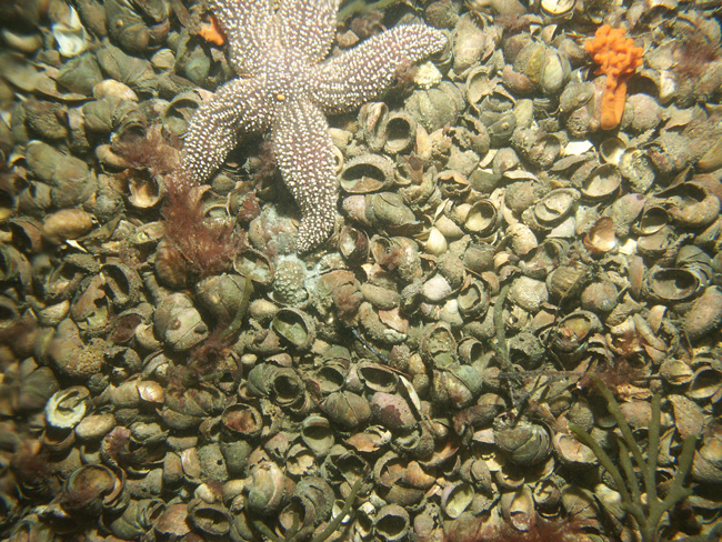
Bottom photographs acquired at 48 sample stations in Red Brook Harbor, MA, during USGS survey 09018. Photography was collected in conjunction with sediment samples on November 16th and 17th, 2009, aboard the R/V Rafael. Photographs and samples were collected with the USGS Mini-SEABed Observation and Sampling System (Mini SEABOSS). These photographs were collected to ground-truth (verify) the acoustic datasets that were acquired in Red Brook Harbor. Full-resolution and reduced-resolution photos are available for download.

How was the data set created?

  1. From what previous works were the data drawn?
    Information unavailable from original metadata. (source 1 of 1)
    The source information was incomplete and had to be modified to meet the standard. Assumed to be USGS., unknown, Information unavailable from original metadata..

    Type_of_Source_Media: Information unavailable from original metadata.
    Source_Contribution:
    The Mini SEABOSS was designed specifically for the USGS Woods Hole Science Center's 26-foot research boat, the R/V Rafael. This system is equipped with two video cameras, a digital still camera, and a van Veen grab sampler. This system, weighing approximately 185 lbs, can be used to depths up to 40 meters. The grab itself is raised and lowered with a 3/16-inch Aramid fiber winch-line with a breaking strength of 5,600 pounds. The davit is secured when the Mini SEABOSS is in the water. The electrical cable is on a spring-wound take-up reel with electrical slip rings that is mounted aft of the sampler. This arrangement protects the 0.38-in. multi-conductor cable and keeps the Mini SEABOSS correctly oriented with the boat. This multi-conductor cable enables communication between the ship's lab and the Mini SEABOSS system. The digital camera, a Minolta Dimage 7Hi, is mounted in a machined Delrin housing with a flat port and is set for 2560 x 1920 pixel images at the "fine" setting for compression. This allows the camera to be used for over 200 images with a 1 GB Compact Flash card without downloading. The system also has a 50 Watt/second flash unit powered by 8 AA batteries. Two battery-powered lasers are set 15 cm apart for scale measurements. The red laser dots can some times be seen in the photo depending on the bottom type and the distance to the sea floor. A third battery powered laser is positioned at an angle so that when it intersects the other lasers, the Mini SEABOSS is at the optimum height off the bottom for a still photograph. The camera is set to a manual focus and set to a default focus distance once the camera is powered up. The default focus distance is slightly less than the optimum height above the seafloor to account for optical distortion under water.
  2. How were the data generated, processed, and modified?
    Date: 2009 (process 1 of 6)
    The USGS Mini SEABOSS system was deployed to capture still photos and bottom imagery as part of the Red Brook Harbor survey. This system was used to obtain 5 to 10 still photographs at each station as the RV Rafael drifted over the seabed for approximately 2 minutes. The third laser on the system was set to an angle such that the optimum photograph height was 60 cm. The default focus on the camera was set to 50 cm. The imaged area is most often within .3 to 1 meter from left to right. Other camera settings are as follows: aperture is set at f/8; shutter speed is 1/250 second; digital Effects settings are Color +1, Contrast +1, and Filter +1 (Warming). The camera time is set to GMT. A total of 300 images of the sea floor were acquired within the study area over two survey days. Although the images themselves have no georeferencing information, the navigation related to each photograph is available in an ESRI formatted shapefile, downloadable at http://pubs.usgs.gov/of/2010/1091/GIS/shapefile/RB_BottomPhotos.zip Person who carried out this activity:
    Dann Blackwood
    U.S. Geological Survey
    Photographer
    384 Woods Hole Road
    Woods Hole, MA
    USA

    (508) 548-8700 x2227 (voice)
    (508) 457-2310 (FAX)
    dblackwood@usgs.gov
    Date: 2010 (process 2 of 6)
    The full-resolution JPEG images (2560x1920 pixels) were downsampled using Photoshop CS4 to create JPEG images with 600 x 450 pixels. Both the full-resolution and downsampled photos are available for download. Person who carried out this activity:
    Aaron Turecek
    U.S. Geological Survey
    Geographer
    384 Woods Hole Rd.
    Woods Hole, MA
    USA

    508-548-8700 x2230 (voice)
    508-457-2310 (FAX)
    aturecek@usgs.gov
    Date: 15-Apr-2016 (process 3 of 6)
    Edits to the metadata were made to fix any errors that MP v 2.9.32 flagged. This is necessary to enable the metadata to be successfully harvested for various data catalogs. In some cases, this meant adding text "Information unavailable" or "Information unavailable from original metadata" for those required fields that were left blank. Other minor edits were probably performed (title, publisher, publication place, etc.). Fixed URL in abstract. The source information was incomplete and had to be modified to meet the standard. The distribution format name was modified in an attempt to be more consistent with other metadata files of the same data format. The metadata date (but not the metadata creator) was edited to reflect the date of these changes. The metadata available from a harvester may supersede metadata bundled within a download file. Compare the metadata dates to determine which metadata file is most recent. Person who carried out this activity:
    U.S. Geological Survey
    Attn: VeeAnn A. Cross
    Marine Geologist
    384 Woods Hole Rd.
    Woods Hole, MA

    508-548-8700 x2251 (voice)
    508-457-2310 (FAX)
    vatnipp@usgs.gov
    Date: 20-Jul-2018 (process 4 of 6)
    USGS Thesaurus keywords added to the keyword section. Person who carried out this activity:
    U.S. Geological Survey
    Attn: VeeAnn A. Cross
    Marine Geologist
    384 Woods Hole Road
    Woods Hole, MA

    508-548-8700 x2251 (voice)
    508-457-2310 (FAX)
    vatnipp@usgs.gov
    Date: 18-Nov-2019 (process 5 of 6)
    Crossref DOI link was added as the first link in the metadata. Person who carried out this activity:
    U.S. Geological Survey
    Attn: VeeAnn A. Cross
    Marine Geologist
    384 Woods Hole Road
    Woods Hole, MA

    508-548-8700 x2251 (voice)
    508-457-2310 (FAX)
    vatnipp@usgs.gov
    Date: 08-Sep-2020 (process 6 of 6)
    Added keywords section with USGS persistent identifier as theme keyword. Person who carried out this activity:
    U.S. Geological Survey
    Attn: VeeAnn A. Cross
    Marine Geologist
    384 Woods Hole Road
    Woods Hole, MA

    508-548-8700 x2251 (voice)
    508-457-2310 (FAX)
    vatnipp@usgs.gov
  3. What similar or related data should the user be aware of?
    Blackwood, D., and Parolski, K., 2001, Seabed observation and sampling system: Sea Technology v. 42, no. 2, p. 39-43.

    Barnhardt, Walter A., Andrews, Brian D., and Butman, Bradford, 2006, High-Resolution Geologic Mapping of the Inner Continental Shelf: Nahant to Gloucester, Massachusetts: Open-File Report 2005-1293, U.S. Geological Survey, Reston, VA.

    Online Links:

    Ackerman, Seth D., Butman, Bradford, Barnhardt, Walter A., Danforth, William W., and Crocker, James M., 2006, High-Resolution Geologic Mapping of the Inner Continental Shelf: Boston Harbor and Approaches, Massachusetts: Open-File Report 2006-1008, U.S. Geological Survey, Reston, VA.

    Online Links:

    Barnhardt, Walter A., Andrews, Brian D., Ackerman, Seth D., Baldwin, Wayne E., and Hein, Christopher J., 2009, High-Resolution Geologic Mapping of the Inner Continental Shelf: Cape Ann to Salisbury Beach, Massachusetts: Open-File Report 2007-1373, U.S. Geological Survey, Reston, VA.

    Online Links:

    Barnhardt, Walter A., Ackerman, Seth D., Andrews, Brian D., and Baldwin, Wayne E., 2010, Geophysical and Sampling Data from the Inner Continental Shelf: Duxbury to Hull, Massachusetts: Open-File Report 2009-1072, U.S. Geological Survey, Reston, VA.

    Online Links:


How reliable are the data; what problems remain in the data set?

  1. How well have the observations been checked?
  2. How accurate are the geographic locations?
    The location of each photograph is represented in the associated photo location shapefile (http://pubs.usgs.gov/of/2010/1091/GIS/shapefile/RB_BottomPhotos.zip). Horizontal positions for photograph locations were provided by a Differential Global Positioning System (DGPS) with an estimated accuracy of ± 2 meters. However, the recorded position of each photograph is actually the position of the DGPS antenna on the survey vessel, not the Mini-SEABOSS sampler. The Mini-SEABOSS was deployed approximately 5 meters astern of the DGPS antenna, off the starboard side of the R/V Rafael. In addition to this 5-meter offset, currents may have caused the Mini-SEABOSS to drift horizontally from the survey vessel. Based on the various horizontal offsets, a conservative estimate for the horizontal accuracy of the Mini-SEABOSS locations for the Red Brook Harbor survey is 10-15 meters.
  3. How accurate are the heights or depths?
  4. Where are the gaps in the data? What is missing?
    A total of 300 photographs acquired at 48 planned sample stations within the Red Brook Harbor survey area are included in this dataset. The sea floor composition prohibited acquiring sediment samples at seven of the planned sample stations, so in these instances photographs do not have a corresponding sediment sample. Photography and sediment samples were collected with the USGS Mini-SEABOSS sampling device. Photographs accidentally acquired on deck or in the water column were not included in this dataset.
  5. How consistent are the relationships among the observations, including topology?
    Gaps in sequential photo numbers exist. Photographs accidentally acquired on deck or in the water column were not included in this dataset.

How can someone get a copy of the data set?

Are there legal restrictions on access or use of the data?
Access_Constraints: None
Use_Constraints:
Public domain data from the U.S. Government are freely redistributable with proper metadata and source attribution. Please recognize the U.S. Geological Survey as the source of this information.
  1. Who distributes the data set? (Distributor 1 of 1)
    Aaron Turecek
    U.S. Geological Survey
    Geologist
    384 Woods Hole Rd.
    Woods Hole, MA
    USA

    508-548-8700 (voice)
    508-457-2310 (FAX)
    aturecek@usgs.gov
  2. What's the catalog number I need to order this data set? Downloadable Data
  3. What legal disclaimers am I supposed to read?
    Neither the U.S. Government, the Department of the Interior, nor the USGS, nor any of their employees, contractors, or subcontractors, make any warranty, express or implied, nor assume any legal liability or responsibility for the accuracy, completeness, or usefulness of any information, apparatus, product, or process disclosed, nor represent that its use would not infringe on privately owned rights. The act of distribution shall not constitute any such warranty, and no responsibility is assumed by the USGS in the use of these data or related materials. Any use of trade, product, or firm names is for descriptive purposes only and does not imply endorsement by the U.S. Government.
  4. How can I download or order the data?
  5. What hardware or software do I need in order to use the data set?
    These data are available as JPEG images. To utilize these data, the user must have an image viewer capable of opening JPEG images.

Who wrote the metadata?

Dates:
Last modified: 16-Nov-2021
Metadata author:
Aaron Turecek
U.S. Geological Survey
Geographer
384 Woods Hole Rd.
Woods Hole, MA
USA

508-548-8700 x2230 (voice)
508-457-2310 (FAX)
whsc_data_contact@usgs.gov
Contact_Instructions:
The metadata contact email address is a generic address in the event the metadata contact is no longer with the USGS or the email is otherwise invalid.
Metadata standard:
FGDC Content Standards for Digital Geospatial Metadata (FGDC-STD-001-1998)

This page is <https://cmgds.marine.usgs.gov/catalog/whcmsc/open_file_report/ofr2010-1091/RB_BottomPhotos.jpg.faq.html>
Generated by mp version 2.9.50 on Tue Nov 16 10:06:39 2021